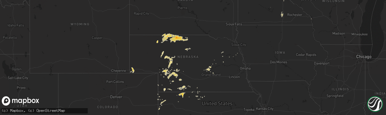
Hail Map in Nebraska on June 6, 2014
The weather event in Nebraska on June 6, 2014 includes Hail map. 20 states and 973 cities were impacted and suffered possible damage. The total estimated number of properties impacted is 0.
Want more than just the map?
Turn this storm into a full workflow.
- Owner + property data so you know who to knock
- OnDemand branded weather history reports to win the "did we even have hail?" argument
- RoofTrace estimate so reps stop guessing numbers at the door
Bought this map? Upgrade within 7 days and we'll credit the $230. (10-15 min setup call)
Hail
0
Estimated number of impacted properties by a 1.00" hail or larger0
Estimated number of impacted properties by a 1.75" hail or larger0
Estimated number of impacted properties by a 2.50" hail or largerStorm reports in Nebraska
Nebraska
| Date | Description |
|---|---|
| 06/06/20146:30 PM CDT | Tree limbs 2-3 inches in diameter down. Time estimated from radar. |
| 06/06/20146:28 PM CDT | A local report indicates 60 MPH wind near HAIGLER |
| 06/06/20146:22 PM CDT | A local report indicates 68 MPH wind near 3 NE BENKELMAN |
| 06/06/20146:20 PM CDT | A local report indicates 67 MPH wind near BENKELMAN |
| 06/06/20145:18 PM CDT | A local report indicates 85 MPH wind near 3 ENE NORTH PLATTE |
| 06/06/20145:15 PM CDT | Semi van trailer blow over at nebraska machinery. |
| 06/06/20145:15 PM CDT | A local report indicates 60 MPH wind near 3 ENE NORTH PLATTE |
| 06/06/20145:00 PM CDT | Pea to quarter sized hail. Torrential rainfall. Winds gusted as high as an estimated 50 mph. |
| 06/06/20143:47 PM CDT | A local report indicates 1.50 inch wind near VALENTINE |
| 06/06/20143:40 PM CDT | A local report indicates 1.00 inch wind near 6 WNW PAXTON |
| 06/06/20143:30 PM CDT | Two hangars destroyed and 6 airplanes damaged at valentine airport. |
| 06/06/20143:15 PM CDT | Delayed report of tornado near cody. Time is approximate. No damage is known at this time. |
| 06/06/20143:00 PM CDT | A local report indicates 2.00 inch wind near 11 WSW VALENTINE |
| 06/06/20142:55 PM CDT | A local report indicates a tornado near 4 W BUSHNELL |
| 06/06/20142:55 PM CDT | The tornado touched down 7 south and lifted. |
| 06/06/20142:52 PM CDT | A local report indicates a tornado near 7 SE BUSHNELL |
| 06/06/20142:52 PM CDT | Near the airport. |
| 06/06/20142:45 PM CDT | A local report indicates 1.00 inch wind near 5 E OGALLALA |
| 06/06/20142:41 PM CDT | Pea size to golf ball size hail ongoing. |
| 06/06/20142:35 PM CDT | A local report indicates a tornado near 7 S BUSHNELL |
| 06/06/20142:29 PM CDT | A local report indicates 1.50 inch wind near 4 E BUSHNELL |
| 06/06/20142:05 PM CDT | A local report indicates 60 MPH wind near CODY |
| 06/06/20142:00 PM CDT | A local report indicates 1.00 inch wind near 6 W CODY |
| 06/06/20142:00 PM CDT | A power pole was snapped approximately one half mile east of cody...causing a several hour power outage in cody. Delayed report from june 6th. |
| 06/06/20142:00 PM CDT | Delayed report from june 6th. Brief tornado occurred one mile west of cody. Short lived tornado touched down on top of a sandhill with no damage noted. Corrected time o |
| 06/06/20141:30 PM CDT | A local report indicates 1.00 inch wind near 4 S ELI |
| 06/06/20141:25 PM CDT | A local report indicates 1.25 inch wind near 10 NNE HYANNIS |
| 06/06/20141:05 PM CDT | Fire department reported the only damage was weeds and a tarp which wrapped around a power line. No other significant impacts were noted. Delayed report from june 6th. |
| 06/06/201412:41 PM CDT | Few hail stones to size of golf balls. On edge of storm. |
| 06/06/201412:00 AM CDT | 2-inch diameter tree branches down in town. Time est fm radar. |
| 06/05/201410:02 PM CDT | Estimated 60-70 mph winds in alma along with very heavy rain. |
| 06/05/20149:04 PM CDT | Law enforcement reported ping pong size hail 3 miles north of st paul on hiway 281. |
| 06/05/20148:59 PM CDT | Trained spotter reports pea size hail... 60 mph winds and lightning in arapahoe. |
| 06/05/20148:50 PM CDT | Spotter reports ongoing very heavy rainfall and sustained winds peaking near 50 mph with gusts to 60 mph at aroun 850 pm cdt. |
| 06/05/20148:35 PM CDT | Spotter reports sustained winds of near 50 mph gusting to between 60-65. Ongoing now since about 835 pm. |
| 06/05/20148:29 PM CDT | A local report indicates 78 MPH wind near 5 S CAMBRIDGE |
| 06/05/20148:28 PM CDT | Large tree branches of 4 plus inches in diameter are down due to severe thunderstorm winds. |
| 06/05/20148:20 PM CDT | A local report indicates 60 MPH wind near LEBANON |
| 06/05/20148:14 PM CDT | Trained spotter measured wind gust of 68 mph 8 miles south of cambridge. |
| 06/05/20147:52 PM CDT | A local report indicates 71 MPH wind near 2 NE DANBURY |
All States Impacted by Hail Map on June 6, 2014
Cities Impacted by Hail Map on June 6, 2014
- Wray, CO
- Idalia, CO
- Dalhart, TX
- Norcatur, KS
- Oberlin, KS
- La Loma, NM
- Smithville, GA
- Sunray, TX
- Saint Paul, NE
- Dannebrog, NE
- West Union, SC
- Holly, CO
- Stratton, CO
- Vona, CO
- Stratton, NE
- Loco, OK
- Duncan, OK
- Graham, OK
- Healdton, OK
- Fernandina Beach, FL
- Callahan, FL
- Pampa, TX
- Bushnell, NE
- Spearman, TX
- Stinnett, TX
- Stratford, TX
- Bison, OK
- Douglas, OK
- Lowndesboro, AL
- Hope Hull, AL
- Montgomery, AL
- Palestine, AR
- Muscle Shoals, AL
- Hollis, OK
- Burlington, CO
- Raton, NM
- Trinchera, CO
- Rockledge, GA
- East Dublin, GA
- Adrian, GA
- Cody, NE
- Nenzel, NE
- Owatonna, MN
- Waseca, MN
- Shattuck, OK
- Laverne, OK
- Elsie, NE
- Wallace, NE
- Chandler, OK
- Lookeba, OK
- Tuthill, SD
- Merriman, NE
- Jennings, KS
- Madill, OK
- Crookston, NE
- Waterford, MS
- Como, MS
- Lagrange, GA
- Arlington, TN
- Miami, TX
- Canadian, TX
- Ellabell, GA
- Enid, OK
- Wagon Mound, NM
- Kensington, KS
- West Blocton, AL
- Kimball, NE
- Holyoke, CO
- Haxtun, CO
- Henderson, TN
- Cherryvale, KS
- Sublette, KS
- Grady, NM
- Hennepin, OK
- Denmark, TN
- Jackson, TN
- Mooreland, OK
- Cullman, AL
- Bamberg, SC
- Solano, NM
- Gruver, TX
- Mosquero, NM
- Medicine Lodge, KS
- Sharon, KS
- Turrell, AR
- Earle, AR
- Tyronza, AR
- Cope, SC
- Branchville, SC
- Smoaks, SC
- Lodge, SC
- Ruffin, SC
- Vega, TX
- Macclenny, FL
- Glen Saint Mary, FL
- Sanderson, FL
- Eclectic, AL
- Lamar, AR
- Wellston, OK
- Rogersville, AL
- Healy, KS
- Borger, TX
- Skellytown, TX
- Jasper, FL
- Burbank, OK
- Akron, CO
- Marion Junction, AL
- Uniontown, AL
- Marion, AL
- Pell City, AL
- Riverside, AL
- Weston, CO
- Boncarbo, CO
- Trinidad, CO
- Weatherford, OK
- Keystone, NE
- Wellington, TX
- Larkspur, CO
- Jackson, GA
- Lamar, MO
- Calera, AL
- Texola, OK
- Erick, OK
- Shamrock, TX
- Brinkley, AR
- Philadelphia, MS
- Haigler, NE
- Smithville, OK
- Watson, OK
- Lexington, MS
- Elida, NM
- Hilliard, FL
- Clanton, AL
- Jemison, AL
- Thorsby, AL
- Verbena, AL
- Mullen, NE
- Comanche, OK
- Walters, OK
- Kit Carson, CO
- Syracuse, KS
- Kendall, KS
- Dodge City, KS
- New Raymer, CO
- Ada, OK
- Kersey, CO
- Hector, AR
- Dover, AR
- Maxwell, NM
- Balko, OK
- Stoneham, CO
- Padroni, CO
- Merino, CO
- Powhatan, AR
- Black Rock, AR
- Iliff, CO
- Crook, CO
- Sedgwick, CO
- Seneca, SC
- Orchard, CO
- Freedom, OK
- Beaver, OK
- Buffalo, OK
- Follett, TX
- May, OK
- Peetz, CO
- Hogansville, GA
- Grantville, GA
- North Platte, NE
- Plains, KS
- Linden, TN
- Decaturville, TN
- Kress, TX
- Paxton, NE
- Ogallala, NE
- Yuma, CO
- Cambridge, NE
- Bartley, NE
- Live Oak, FL
- Keysville, GA
- Letohatchee, AL
- Senoia, GA
- Gay, GA
- Montevallo, AL
- Brierfield, AL
- Alabaster, AL
- Helena, AL
- Medon, TN
- Toone, TN
- Hodges, AL
- Vina, AL
- Ainsworth, NE
- Briggsdale, CO
- Sarah, MS
- Julesburg, CO
- Gordon, NE
- Arapahoe, NE
- Edison, NE
- Pryor, OK
- Claremore, OK
- Hazen, AR
- Pueblo, CO
- Avondale, CO
- Cimarron, KS
- Madrid, NE
- Guntersville, AL
- Albertville, AL
- Rosston, OK
- Boelus, NE
- Kennedy, AL
- Hershey, NE
- Jet, OK
- Elk River, MN
- Ensign, KS
- Montezuma, KS
- Max, NE
- Aguilar, CO
- Longdale, OK
- Nash, OK
- Okmulgee, OK
- Beggs, OK
- Brule, NE
- Crawfordsville, AR
- Hartley, TX
- Wood Lake, NE
- Jacksonville, AL
- Hyannis, NE
- Carrier, OK
- Goltry, OK
- Belzoni, MS
- Ardmore, OK
- Wilson, OK
- Jacksonville, GA
- Stratford, OK
- Kilgore, NE
- Sutherland, NE
- Tryon, NE
- Louisville, AL
- Proctor, AR
- Lawrenceburg, TN
- Woodward, OK
- Fort Supply, OK
- Anniston, AL
- Piedmont, AL
- McRae Helena, GA
- Luray, TN
- Mount Vernon, GA
- Ovid, CO
- Hugoton, KS
- Liberal, KS
- Satanta, KS
- Meade, KS
- Kismet, KS
- Alexander City, AL
- House, NM
- Melrose, NM
- Linn Grove, IA
- Corona, NM
- Bosler, WY
- Rock River, WY
- Hooker, OK
- Stuart, OK
- Chapman, NE
- Saint Edward, NE
- Fullerton, NE
- Forgan, OK
- Lakin, KS
- Northport, AL
- Berry, AL
- Stilwell, OK
- Weleetka, OK
- Lorenzo, TX
- Ralls, TX
- Otis, CO
- Rockville, NE
- Johnstown, NE
- Valentine, NE
- Saint Francis, SD
- Fairview, OK
- Chester, OK
- Clayton, NM
- Kirwin, KS
- Ulysses, KS
- Garden City, KS
- Howells, NE
- Dodson, TX
- Childress, TX
- Butler, GA
- Mauk, GA
- Noble, OK
- Norman, OK
- Wright, KS
- Edson, KS
- Goodland, KS
- Redfield, KS
- Weskan, KS
- Tishomingo, OK
- Milburn, OK
- Saint Francis, KS
- Argonia, KS
- Freeport, KS
- Yulee, FL
- Sheridan Lake, CO
- Willow, OK
- Vinson, OK
- Mangum, OK
- Dublin, GA
- Rentz, GA
- Davis, OK
- Benkelman, NE
- Hartman, AR
- Taloga, OK
- Marlow, OK
- Crawford, OK
- Soperton, GA
- Tarrytown, GA
- Atoka, OK
- Pittsburg, OK
- Ellendale, MN
- Goodwell, OK
- Beulah, CO
- Curtis, NE
- Eva, AL
- Vinemont, AL
- Falkville, AL
- Cheyenne, OK
- Gate, OK
- Ford, KS
- De Soto, GA
- Leesburg, GA
- Perryton, TX
- Bird City, KS
- Washington, OK
- Blanchard, OK
- Coleman, OK
- Clovis, NM
- Ingalls, KS
- Lebanon, NE
- Colorado Springs, CO
- Yoder, CO
- Minneola, KS
- Double Springs, AL
- Albany, GA
- Springview, NE
- Union Springs, AL
- Hennessey, OK
- Marshall, OK
- Idalou, TX
- Slaton, TX
- Fort Stewart, GA
- Cedar, KS
- Gaylord, KS
- Athol, KS
- Hugo, CO
- Marianna, AR
- Moro, AR
- Parks, NE
- Carpenter, WY
- Hereford, CO
- Grover, CO
- Guymon, OK
- Bethune, CO
- Spencer, OK
- Jones, OK
- Arcadia, OK
- Edmond, OK
- Oklahoma City, OK
- Luther, OK
- Cimarron, NM
- Stamford, NE
- Riceboro, GA
- Seiling, OK
- Logan, NM
- Tucumcari, NM
- Marietta, OK
- Camden, AL
- Alberta, AL
- Putnam, OK
- Leedey, OK
- Mathews, AL
- Burns, WY
- Alva, OK
- Sawyerville, AL
- Forkland, AL
- Boligee, AL
- Cherokee, OK
- Pawnee, OK
- Turpin, OK
- Plainview, TX
- Mill Creek, OK
- Mannsville, OK
- Hinton, OK
- Cordele, GA
- McCook, NE
- Cheyenne, WY
- Brookwood, AL
- Adger, AL
- Perryville, AR
- Causey, NM
- Waukomis, OK
- Tyrone, OK
- Gray, GA
- Macon, GA
- Copeland, KS
- Booker, TX
- Wheeler, TX
- Sparks, OK
- Walhalla, SC
- Paoli, CO
- Rogers, NM
- Sulphur, OK
- Hayes Center, NE
- Olar, SC
- Perry, OK
- Tallassee, AL
- Roy, NM
- Amistad, NM
- Nara Visa, NM
- Fort Smith, AR
- Woodrow, CO
- Fay, OK
- Martin, SD
- Clayton, OK
- Pike Road, AL
- Cecil, AL
- Byromville, GA
- Vienna, GA
- Booneville, AR
- Morse, TX
- Elmore City, OK
- Leary, GA
- Deerfield, KS
- Louisville, MS
- Channing, TX
- Henryetta, OK
- Anoka, MN
- Pitts, GA
- Adair, OK
- Stapleton, NE
- Altus, AR
- Farwell, NE
- Ratliff City, OK
- Wynnewood, OK
- Springer, OK
- Dougherty, OK
- Lone Grove, OK
- Ringling, OK
- Colony, OK
- Corn, OK
- Hydro, OK
- Dumas, TX
- Gordo, AL
- Aliceville, AL
- Eutaw, AL
- Lithonia, GA
- Sylacauga, AL
- Talladega, AL
- Savannah, GA
- Indianola, NE
- Jerusalem, AR
- Claxton, GA
- Byhalia, MS
- Glencoe, OK
- Tutwiler, MS
- Charleston, MS
- Sumner, MS
- Elba, NE
- Grant, NE
- Castle Rock, CO
- West, MS
- Fredonia, KS
- Leslie, GA
- Eatonton, GA
- Monticello, GA
- Haddock, GA
- Safford, AL
- Rush, CO
- Statenville, GA
- Lake Park, GA
- Tuscaloosa, AL
- Mount Hope, AL
- Stillwater, OK
- Orlando, OK
- Shidler, OK
- Ripley, TN
- Pauls Valley, OK
- Covington, TN
- Briscoe, TX
- Lexington, AL
- Lamar, CO
- Elbert, CO
- Franktown, CO
- Ashland, KS
- Englewood, KS
- Tribune, KS
- Pritchett, CO
- Glenwood, GA
- Vaughn, NM
- Waynoka, OK
- Batesville, AR
- Williamson, GA
- Concord, GA
- Gordon, GA
- Homerville, GA
- Lake City, KS
- Saint Simons Island, GA
- Lexington, OK
- Wanette, OK
- Bolivar, TN
- Greenville, AL
- Fort Deposit, AL
- Pine Apple, AL
- Minter, AL
- Forest Home, AL
- Hayneville, AL
- Nicollet, MN
- Hickory Ridge, AR
- Custer City, OK
- Rhine, GA
- Yemassee, SC
- Seabrook, SC
- Islandton, SC
- Haswell, CO
- Brent, AL
- Grenada, MS
- Stonewall, OK
- Roff, OK
- Hereford, TX
- Friona, TX
- Summerfield, TX
- Oakwood, OK
- Whitman, NE
- Holcomb, KS
- Karval, CO
- Mcalister, NM
- Selma, AL
- Wellfleet, NE
- Dickens, NE
- Ocate, NM
- Jetmore, KS
- Marshallville, GA
- Harris, MN
- Argyle, GA
- Colt, AR
- Wynne, AR
- Pulaski, GA
- Metter, GA
- Register, GA
- Sterling, CO
- Alcova, WY
- Arapahoe, CO
- Naponee, NE
- Fayetteville, AR
- Waycross, GA
- Tecumseh, OK
- Banks, AL
- Foster, OK
- Crescent, OK
- Meadow Grove, NE
- Pierce, NE
- Norfolk, NE
- Okemah, OK
- Eufaula, AL
- Lambert, MS
- Bryceville, FL
- Greenville, MS
- Sheldon, MO
- Saint George, GA
- Paoli, OK
- Wayne, OK
- Milledgeville, GA
- Lubbock, TX
- Fort Sumner, NM
- Dexter, GA
- Champion, NE
- Alpine, AL
- Fort Morgan, CO
- Vance, AL
- Tumbling Shoals, AR
- Ida, AR
- Drasco, AR
- Wrightsville, GA
- Kite, GA
- Madison, NE
- Ridgeland, WI
- Wheeler, WI
- Maysville, OK
- Dardanelle, AR
- Delaware, AR
- Wilmore, KS
- Ozark, AR
- Forrest City, AR
- Tulia, TX
- Spearville, KS
- Geary, OK
- Sweetwater, OK
- Yale, OK
- La Crescent, MN
- Millport, AL
- Silver City, MS
- Maywood, NE
- Maxwell, NE
- Moorefield, NE
- Warrenton, GA
- Blakely, GA
- Haynes, AR
- Jacksonville, FL
- Marked Tree, AR
- Waynesboro, TN
- Brunswick, GA
- Rochelle, GA
- Huntsville, AR
- Witter, AR
- Conyers, GA
- Covington, GA
- Oxford, GA
- Batesville, MS
- Cuba, AL
- Scott City, KS
- Oakfield, GA
- Sylvester, GA
- Morrilton, AR
- Tillatoba, MS
- Scobey, MS
- Abbeville, AL
- Georgetown, GA
- Holcomb, MS
- Toomsboro, GA
- McIntyre, GA
- Yeso, NM
- Fowler, KS
- Equality, AL
- Rockford, AL
- Cove, AR
- Wickes, AR
- McCrory, AR
- Fitzpatrick, AL
- Jasper, AL
- Conway Springs, KS
- Rogersville, MO
- Arapaho, OK
- Thomas, OK
- Newkirk, OK
- Maple City, KS
- Trenton, SC
- Pulaski, TN
- Glennville, GA
- Milan, GA
- Cedar Rapids, NE
- Elba, AL
- Glenwood, AL
- Bath Springs, TN
- Medford, MN
- New Richland, MN
- Saint Paul, MN
- Lakeville, MN
- Wolbach, NE
- Titus, AL
- Cecil, AR
- Elgin, OK
- Hillsboro, GA
- Elk City, OK
- Brundidge, AL
- Clayton, AL
- Liberal, MO
- Mindenmines, MO
- Sentinel, OK
- Lone Wolf, OK
- Carter, OK
- Tuskegee, AL
- Blanco, OK
- Vilonia, AR
- El Paso, AR
- Earlsboro, OK
- Seminole, OK
- Eads, TN
- Brighton, TN
- Mason, TN
- Memphis, TN
- Cordova, TN
- Arkansas City, KS
- Stroud, OK
- Depew, OK
- London, AR
- Burlington, OK
- Beech Bluff, TN
- San Jon, NM
- Baconton, GA
- Portia, AR
- Trenton, TN
- Deer Trail, CO
- Jonesboro, AR
- Bono, AR
- Quitman, GA
- Pierceville, KS
- Norton, KS
- Coldwater, MS
- Hernando, MS
- McAlpin, FL
- Thomasville, AL
- Oakman, AL
- Townley, AL
- Waverly, TN
- Walterboro, SC
- Hartselle, AL
- Abbeville, GA
- Pineview, GA
- Sayre, OK
- Lindsay, OK
- Bradley, OK
- Ehrhardt, SC
- Tennille, GA
- Selden, KS
- Lonoke, AR
- Hackett, AR
- Cameron, OK
- Happy, TX
- Wayside, TX
- Camargo, OK
- Vici, OK
- Anthony, KS
- Scranton, AR
- Knoxville, AR
- Iuka, MS
- Albion, NE
- Troy, AL
- Moultrie, GA
- Norman Park, GA
- Phillips, NE
- Prague, OK
- Dundee, MS
- Grand Island, NE
- Hale Center, TX
- Tuskegee Institute, AL
- Sturgis, MS
- Orrville, AL
- Paden, OK
- Boley, OK
- Castle, OK
- Arabi, GA
- Seibert, CO
- Flagler, CO
- Reagan, TN
- Noxapater, MS
- Fargo, OK
- Jacksonville, AR
- Rosalie, NE
- Pine Bluffs, WY
- Paris, AR
- Chauncey, GA
- Sledge, MS
- Boone, CO
- Twin City, GA
- Swainsboro, GA
- Pep, NM
- Portales, NM
- Middleburg, FL
- Alma, NE
- Olive Branch, MS
- Benedict, KS
- Manchester, OK
- Wakita, OK
- Weldona, CO
- Augusta, AR
- Courtland, AL
- Moulton, AL
- Hinesville, GA
- Reydon, OK
- Lepanto, AR
- Platte Center, NE
- Long Pine, NE
- Jennings, FL
- Mclean, TX
- Claude, TX
- Saint Libory, NE
- Rich Hill, MO
- Hume, MO
- Akron, AL
- Gallion, AL
- Byars, OK
- Town Creek, AL
- Bristow, OK
- Walsenburg, CO
- Levelland, TX
- Newnan, GA
- Sharpsburg, GA
- Cherokee, IA
- Atkins, AR
- Danville, AL
- Hanna, WY
- Fayette, AL
- Brady, NE
- Palisade, NE
- Mayo, FL
- Wyoming, MN
- Mcalester, OK
- Woodstock, AL
- Madison, AL
- Lumpkin, GA
- Pottsville, AR
- Russellville, AR
- Scotts Hill, TN
- Wapanucka, OK
- Statesboro, GA
- Ringwood, OK
- Helena, OK
- Grove Hill, AL
- Dickinson, AL
- Fowler, CO
- Porum, OK
- Rutledge, AL
- Phil Campbell, AL
- Amorita, OK
- Mena, AR
- Okeene, OK
- Hitchcock, OK
- Kingfisher, OK
- Red Banks, MS
- Dighton, KS
- Center Ridge, AR
- Cleveland, AR
- Gill, CO
- Cascilla, MS
- Amherst, TX
- Enochs, TX
- Ludowici, GA
- Allenhurst, GA
- Wetumpka, AL
- Duck Hill, MS
- Carlsbad, NM
- Canute, OK
- Humphrey, NE
- Silverton, TX
- West Point, NE
- Watonga, OK
- Canton, OK
- Weaver, AL
- Phillipsburg, KS
- Quincy, FL
- Smith Center, KS
- Walsh, CO
- Cushing, OK
- Limon, CO
- Townsend, GA
- Sardis, MS
- Hanceville, AL
- Salem, AL
- Alamo, TN
- Friendship, TN
- Florence, AL
- Little Rock, AR
- Du Pont, GA
- Somerville, AL
- Dudley, GA
- Chester, GA
- Morton, TX
- Dennis, KS
- Autaugaville, AL
- Peyton, CO
- Brush, CO
- Snyder, CO
- Hillrose, CO
- Centreville, AL
- Lawley, AL
- Brooks, GA
- Franklin, GA
- Sudan, TX
- Maple, TX
- Dawson, GA
- Loving, NM
- Cadwell, GA
- Springfield, CO
- Sedalia, CO
- Fitzhugh, OK
- Norway, SC
- Meno, OK
- Broken Arrow, OK
- Dimmitt, TX
- Oxford, MS
- Cleveland, MS
- Merigold, MS
- Isabel, KS
- Pinson, TN
- Winona, MS
- McCarley, MS
- Arnett, OK
- Elkhart, KS
- Tyler, AL
- Epes, AL
- Greensboro, AL
- Marks, MS
- Clopton, AL
- Newville, AL
- Dexter, KS
- Rosemount, MN
- Burnsville, MN
- Coalgate, OK
- Union, MS
- Notasulga, AL
- Germantown, TN
- Toomsuba, MS
- Bancroft, NE
- Fairfax, OK
- Beaver City, NE
- Almena, KS
- Hillsboro, AL
- Granite, OK
- Glade, KS
- Elmore, AL
- Deatsville, AL
- Trinity, AL
- Booneville, MS
- Carthage, MS
- Bradford, AR
- Elkmont, AL
- Venango, NE
- Republican City, NE
- Newbern, AL
- Compton, AR
- Hollywood, SC
- Adams Run, SC
- Wardville, OK
- Drew, MS
- Ruleville, MS
- Wilsonville, NE
- Monroe, GA
- Loganville, GA
- Canyon, TX
- Groom, TX
- Amarillo, TX
- Wildorado, TX
- Panhandle, TX
- Alexander, KS
- Bazine, KS
- Leoti, KS
- Bison, KS
- Albert, KS
- Rush Center, KS
- Otis, KS
- Great Bend, KS
- Nekoma, KS
- Hoisington, KS
- La Crosse, KS
- Olmitz, KS
- Ellinwood, KS
- McCracken, KS
- Hudson, KS
- Ness City, KS
- Farmville, NC
- Greenville, NC
- Chocowinity, NC
- Blounts Creek, NC
- Aurora, NC
- Edward, NC
- Clinton, NC
- La Grange, NC
- Snow Hill, NC
- Newport, NC
- Swansboro, NC
- Stella, NC
- Emerald Isle, NC
- Granby, MO
- Pierce City, MO
- Stark City, MO
- Neosho, MO
- Mount Vernon, MO
- Everton, MO
- Ash Grove, MO
- Miller, MO
- Bois D Arc, MO
- Halltown, MO
- Willard, MO
- Stotts City, MO


