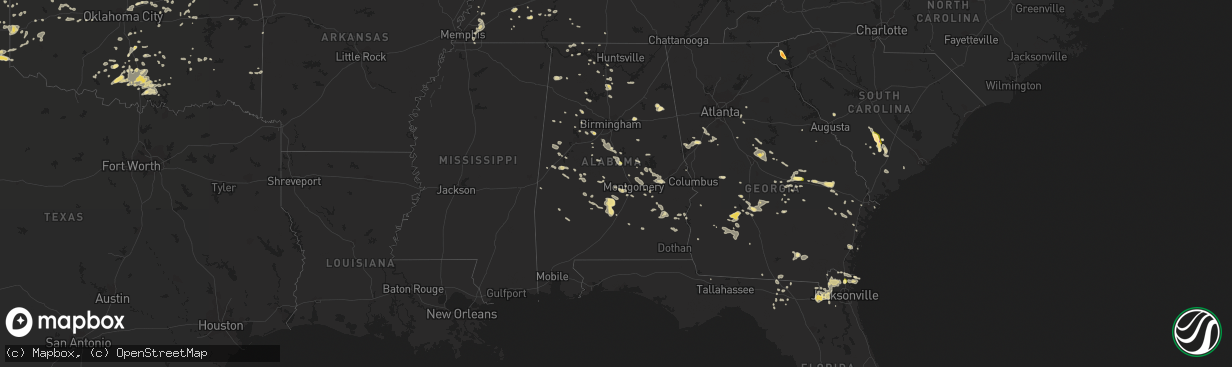
Hail Map in Alabama on June 6, 2014
The weather event in Alabama on June 6, 2014 includes Hail map. 20 states and 973 cities were impacted and suffered possible damage. The total estimated number of properties impacted is 287.
Want more than just the map?
Turn this storm into a full workflow.
- Owner + property data so you know who to knock
- OnDemand branded weather history reports to win the "did we even have hail?" argument
- RoofTrace estimate so reps stop guessing numbers at the door
Bought this map? Upgrade within 7 days and we'll credit the $230. (10-15 min setup call)
Hail
287
Estimated number of impacted properties by a 1.00" hail or larger0
Estimated number of impacted properties by a 1.75" hail or larger0
Estimated number of impacted properties by a 2.50" hail or largerStorm reports in Alabama
Alabama
| Date | Description |
|---|---|
| 06/06/20146:50 PM CDT | Trees down near county road 8 |
| 06/06/20146:30 PM CDT | Several trees down |
| 06/06/20146:05 PM CDT | Trees reported down along hagler coaling road near coaling. |
| 06/06/20145:52 PM CDT | A local report indicates 1.00 inch wind near 4 SE CLANTON |
| 06/06/20145:39 PM CDT | Report of trees down on rockhouse road. |
| 06/06/20145:29 PM CDT | Report of trees down on rockhouse road. |
| 06/06/20144:48 PM CDT | Powerlines were reported down along notasulga road in east tallassee. |
| 06/06/20144:39 PM CDT | Report of trees down on rockhouse road. |
| 06/06/20144:28 PM CDT | Trees blown down near martin dam in the union community. |
| 06/06/20144:28 PM CDT | Several trees were reported down blocking cherokee heights road and on martin dam road. |
| 06/06/20143:30 PM CDT | Power line and a few trees down |
| 06/06/20143:15 PM CDT | A tree was reported down on a house along rabbitown road in east calhoun county. |
| 06/06/20143:13 PM CDT | Several trees were blown down and one building destroyed along whites gap road and on old highway 9. |
| 06/06/20142:57 PM CDT | A few trees blown down near highway 31. |
| 06/06/20142:48 PM CDT | Small trees blown down near highway 51 and double bridge road. |
| 06/06/201411:53 AM CDT | Tree down near intersection of u.s. 11 and cr 239 north of hammondville. Time estimated from radar. |
| 06/06/201411:45 AM CDT | Tree down near intersection of county road 121 and country lane near ider. Time estimated from radar. |
| 06/05/20149:25 PM CDT | Power line down in cottonwood |
| 06/05/20149:23 PM CDT | Several trees and power lines downed in geneva county. |
| 06/05/20148:20 PM CDT | Numerous trees and power lines down countywide. |
| 06/05/20147:20 PM CDT | Numerous trees and power lines down countywide. |
All States Impacted by Hail Map on June 6, 2014
Cities Impacted by Hail Map on June 6, 2014
- Wray, CO
- Idalia, CO
- Dalhart, TX
- Norcatur, KS
- Oberlin, KS
- La Loma, NM
- Smithville, GA
- Sunray, TX
- Saint Paul, NE
- Dannebrog, NE
- West Union, SC
- Holly, CO
- Stratton, CO
- Vona, CO
- Stratton, NE
- Loco, OK
- Duncan, OK
- Graham, OK
- Healdton, OK
- Fernandina Beach, FL
- Callahan, FL
- Pampa, TX
- Bushnell, NE
- Spearman, TX
- Stinnett, TX
- Stratford, TX
- Bison, OK
- Douglas, OK
- Lowndesboro, AL
- Hope Hull, AL
- Montgomery, AL
- Palestine, AR
- Muscle Shoals, AL
- Hollis, OK
- Burlington, CO
- Raton, NM
- Trinchera, CO
- Rockledge, GA
- East Dublin, GA
- Adrian, GA
- Cody, NE
- Nenzel, NE
- Owatonna, MN
- Waseca, MN
- Shattuck, OK
- Laverne, OK
- Elsie, NE
- Wallace, NE
- Chandler, OK
- Lookeba, OK
- Tuthill, SD
- Merriman, NE
- Jennings, KS
- Madill, OK
- Crookston, NE
- Waterford, MS
- Como, MS
- Lagrange, GA
- Arlington, TN
- Miami, TX
- Canadian, TX
- Ellabell, GA
- Enid, OK
- Wagon Mound, NM
- Kensington, KS
- West Blocton, AL
- Kimball, NE
- Holyoke, CO
- Haxtun, CO
- Henderson, TN
- Cherryvale, KS
- Sublette, KS
- Grady, NM
- Hennepin, OK
- Denmark, TN
- Jackson, TN
- Mooreland, OK
- Cullman, AL
- Bamberg, SC
- Solano, NM
- Gruver, TX
- Mosquero, NM
- Medicine Lodge, KS
- Sharon, KS
- Turrell, AR
- Earle, AR
- Tyronza, AR
- Cope, SC
- Branchville, SC
- Smoaks, SC
- Lodge, SC
- Ruffin, SC
- Vega, TX
- Macclenny, FL
- Glen Saint Mary, FL
- Sanderson, FL
- Eclectic, AL
- Lamar, AR
- Wellston, OK
- Rogersville, AL
- Healy, KS
- Borger, TX
- Skellytown, TX
- Jasper, FL
- Burbank, OK
- Akron, CO
- Marion Junction, AL
- Uniontown, AL
- Marion, AL
- Pell City, AL
- Riverside, AL
- Weston, CO
- Boncarbo, CO
- Trinidad, CO
- Weatherford, OK
- Keystone, NE
- Wellington, TX
- Larkspur, CO
- Jackson, GA
- Lamar, MO
- Calera, AL
- Texola, OK
- Erick, OK
- Shamrock, TX
- Brinkley, AR
- Philadelphia, MS
- Haigler, NE
- Smithville, OK
- Watson, OK
- Lexington, MS
- Elida, NM
- Hilliard, FL
- Clanton, AL
- Jemison, AL
- Thorsby, AL
- Verbena, AL
- Mullen, NE
- Comanche, OK
- Walters, OK
- Kit Carson, CO
- Syracuse, KS
- Kendall, KS
- Dodge City, KS
- New Raymer, CO
- Ada, OK
- Kersey, CO
- Hector, AR
- Dover, AR
- Maxwell, NM
- Balko, OK
- Stoneham, CO
- Padroni, CO
- Merino, CO
- Powhatan, AR
- Black Rock, AR
- Iliff, CO
- Crook, CO
- Sedgwick, CO
- Seneca, SC
- Orchard, CO
- Freedom, OK
- Beaver, OK
- Buffalo, OK
- Follett, TX
- May, OK
- Peetz, CO
- Hogansville, GA
- Grantville, GA
- North Platte, NE
- Plains, KS
- Linden, TN
- Decaturville, TN
- Kress, TX
- Paxton, NE
- Ogallala, NE
- Yuma, CO
- Cambridge, NE
- Bartley, NE
- Live Oak, FL
- Keysville, GA
- Letohatchee, AL
- Senoia, GA
- Gay, GA
- Montevallo, AL
- Brierfield, AL
- Alabaster, AL
- Helena, AL
- Medon, TN
- Toone, TN
- Hodges, AL
- Vina, AL
- Ainsworth, NE
- Briggsdale, CO
- Sarah, MS
- Julesburg, CO
- Gordon, NE
- Arapahoe, NE
- Edison, NE
- Pryor, OK
- Claremore, OK
- Hazen, AR
- Pueblo, CO
- Avondale, CO
- Cimarron, KS
- Madrid, NE
- Guntersville, AL
- Albertville, AL
- Rosston, OK
- Boelus, NE
- Kennedy, AL
- Hershey, NE
- Jet, OK
- Elk River, MN
- Ensign, KS
- Montezuma, KS
- Max, NE
- Aguilar, CO
- Longdale, OK
- Nash, OK
- Okmulgee, OK
- Beggs, OK
- Brule, NE
- Crawfordsville, AR
- Hartley, TX
- Wood Lake, NE
- Jacksonville, AL
- Hyannis, NE
- Carrier, OK
- Goltry, OK
- Belzoni, MS
- Ardmore, OK
- Wilson, OK
- Jacksonville, GA
- Stratford, OK
- Kilgore, NE
- Sutherland, NE
- Tryon, NE
- Louisville, AL
- Proctor, AR
- Lawrenceburg, TN
- Woodward, OK
- Fort Supply, OK
- Anniston, AL
- Piedmont, AL
- McRae Helena, GA
- Luray, TN
- Mount Vernon, GA
- Ovid, CO
- Hugoton, KS
- Liberal, KS
- Satanta, KS
- Meade, KS
- Kismet, KS
- Alexander City, AL
- House, NM
- Melrose, NM
- Linn Grove, IA
- Corona, NM
- Bosler, WY
- Rock River, WY
- Hooker, OK
- Stuart, OK
- Chapman, NE
- Saint Edward, NE
- Fullerton, NE
- Forgan, OK
- Lakin, KS
- Northport, AL
- Berry, AL
- Stilwell, OK
- Weleetka, OK
- Lorenzo, TX
- Ralls, TX
- Otis, CO
- Rockville, NE
- Johnstown, NE
- Valentine, NE
- Saint Francis, SD
- Fairview, OK
- Chester, OK
- Clayton, NM
- Kirwin, KS
- Ulysses, KS
- Garden City, KS
- Howells, NE
- Dodson, TX
- Childress, TX
- Butler, GA
- Mauk, GA
- Noble, OK
- Norman, OK
- Wright, KS
- Edson, KS
- Goodland, KS
- Redfield, KS
- Weskan, KS
- Tishomingo, OK
- Milburn, OK
- Saint Francis, KS
- Argonia, KS
- Freeport, KS
- Yulee, FL
- Sheridan Lake, CO
- Willow, OK
- Vinson, OK
- Mangum, OK
- Dublin, GA
- Rentz, GA
- Davis, OK
- Benkelman, NE
- Hartman, AR
- Taloga, OK
- Marlow, OK
- Crawford, OK
- Soperton, GA
- Tarrytown, GA
- Atoka, OK
- Pittsburg, OK
- Ellendale, MN
- Goodwell, OK
- Beulah, CO
- Curtis, NE
- Eva, AL
- Vinemont, AL
- Falkville, AL
- Cheyenne, OK
- Gate, OK
- Ford, KS
- De Soto, GA
- Leesburg, GA
- Perryton, TX
- Bird City, KS
- Washington, OK
- Blanchard, OK
- Coleman, OK
- Clovis, NM
- Ingalls, KS
- Lebanon, NE
- Colorado Springs, CO
- Yoder, CO
- Minneola, KS
- Double Springs, AL
- Albany, GA
- Springview, NE
- Union Springs, AL
- Hennessey, OK
- Marshall, OK
- Idalou, TX
- Slaton, TX
- Fort Stewart, GA
- Cedar, KS
- Gaylord, KS
- Athol, KS
- Hugo, CO
- Marianna, AR
- Moro, AR
- Parks, NE
- Carpenter, WY
- Hereford, CO
- Grover, CO
- Guymon, OK
- Bethune, CO
- Spencer, OK
- Jones, OK
- Arcadia, OK
- Edmond, OK
- Oklahoma City, OK
- Luther, OK
- Cimarron, NM
- Stamford, NE
- Riceboro, GA
- Seiling, OK
- Logan, NM
- Tucumcari, NM
- Marietta, OK
- Camden, AL
- Alberta, AL
- Putnam, OK
- Leedey, OK
- Mathews, AL
- Burns, WY
- Alva, OK
- Sawyerville, AL
- Forkland, AL
- Boligee, AL
- Cherokee, OK
- Pawnee, OK
- Turpin, OK
- Plainview, TX
- Mill Creek, OK
- Mannsville, OK
- Hinton, OK
- Cordele, GA
- McCook, NE
- Cheyenne, WY
- Brookwood, AL
- Adger, AL
- Perryville, AR
- Causey, NM
- Waukomis, OK
- Tyrone, OK
- Gray, GA
- Macon, GA
- Copeland, KS
- Booker, TX
- Wheeler, TX
- Sparks, OK
- Walhalla, SC
- Paoli, CO
- Rogers, NM
- Sulphur, OK
- Hayes Center, NE
- Olar, SC
- Perry, OK
- Tallassee, AL
- Roy, NM
- Amistad, NM
- Nara Visa, NM
- Fort Smith, AR
- Woodrow, CO
- Fay, OK
- Martin, SD
- Clayton, OK
- Pike Road, AL
- Cecil, AL
- Byromville, GA
- Vienna, GA
- Booneville, AR
- Morse, TX
- Elmore City, OK
- Leary, GA
- Deerfield, KS
- Louisville, MS
- Channing, TX
- Henryetta, OK
- Anoka, MN
- Pitts, GA
- Adair, OK
- Stapleton, NE
- Altus, AR
- Farwell, NE
- Ratliff City, OK
- Wynnewood, OK
- Springer, OK
- Dougherty, OK
- Lone Grove, OK
- Ringling, OK
- Colony, OK
- Corn, OK
- Hydro, OK
- Dumas, TX
- Gordo, AL
- Aliceville, AL
- Eutaw, AL
- Lithonia, GA
- Sylacauga, AL
- Talladega, AL
- Savannah, GA
- Indianola, NE
- Jerusalem, AR
- Claxton, GA
- Byhalia, MS
- Glencoe, OK
- Tutwiler, MS
- Charleston, MS
- Sumner, MS
- Elba, NE
- Grant, NE
- Castle Rock, CO
- West, MS
- Fredonia, KS
- Leslie, GA
- Eatonton, GA
- Monticello, GA
- Haddock, GA
- Safford, AL
- Rush, CO
- Statenville, GA
- Lake Park, GA
- Tuscaloosa, AL
- Mount Hope, AL
- Stillwater, OK
- Orlando, OK
- Shidler, OK
- Ripley, TN
- Pauls Valley, OK
- Covington, TN
- Briscoe, TX
- Lexington, AL
- Lamar, CO
- Elbert, CO
- Franktown, CO
- Ashland, KS
- Englewood, KS
- Tribune, KS
- Pritchett, CO
- Glenwood, GA
- Vaughn, NM
- Waynoka, OK
- Batesville, AR
- Williamson, GA
- Concord, GA
- Gordon, GA
- Homerville, GA
- Lake City, KS
- Saint Simons Island, GA
- Lexington, OK
- Wanette, OK
- Bolivar, TN
- Greenville, AL
- Fort Deposit, AL
- Pine Apple, AL
- Minter, AL
- Forest Home, AL
- Hayneville, AL
- Nicollet, MN
- Hickory Ridge, AR
- Custer City, OK
- Rhine, GA
- Yemassee, SC
- Seabrook, SC
- Islandton, SC
- Haswell, CO
- Brent, AL
- Grenada, MS
- Stonewall, OK
- Roff, OK
- Hereford, TX
- Friona, TX
- Summerfield, TX
- Oakwood, OK
- Whitman, NE
- Holcomb, KS
- Karval, CO
- Mcalister, NM
- Selma, AL
- Wellfleet, NE
- Dickens, NE
- Ocate, NM
- Jetmore, KS
- Marshallville, GA
- Harris, MN
- Argyle, GA
- Colt, AR
- Wynne, AR
- Pulaski, GA
- Metter, GA
- Register, GA
- Sterling, CO
- Alcova, WY
- Arapahoe, CO
- Naponee, NE
- Fayetteville, AR
- Waycross, GA
- Tecumseh, OK
- Banks, AL
- Foster, OK
- Crescent, OK
- Meadow Grove, NE
- Pierce, NE
- Norfolk, NE
- Okemah, OK
- Eufaula, AL
- Lambert, MS
- Bryceville, FL
- Greenville, MS
- Sheldon, MO
- Saint George, GA
- Paoli, OK
- Wayne, OK
- Milledgeville, GA
- Lubbock, TX
- Fort Sumner, NM
- Dexter, GA
- Champion, NE
- Alpine, AL
- Fort Morgan, CO
- Vance, AL
- Tumbling Shoals, AR
- Ida, AR
- Drasco, AR
- Wrightsville, GA
- Kite, GA
- Madison, NE
- Ridgeland, WI
- Wheeler, WI
- Maysville, OK
- Dardanelle, AR
- Delaware, AR
- Wilmore, KS
- Ozark, AR
- Forrest City, AR
- Tulia, TX
- Spearville, KS
- Geary, OK
- Sweetwater, OK
- Yale, OK
- La Crescent, MN
- Millport, AL
- Silver City, MS
- Maywood, NE
- Maxwell, NE
- Moorefield, NE
- Warrenton, GA
- Blakely, GA
- Haynes, AR
- Jacksonville, FL
- Marked Tree, AR
- Waynesboro, TN
- Brunswick, GA
- Rochelle, GA
- Huntsville, AR
- Witter, AR
- Conyers, GA
- Covington, GA
- Oxford, GA
- Batesville, MS
- Cuba, AL
- Scott City, KS
- Oakfield, GA
- Sylvester, GA
- Morrilton, AR
- Tillatoba, MS
- Scobey, MS
- Abbeville, AL
- Georgetown, GA
- Holcomb, MS
- Toomsboro, GA
- McIntyre, GA
- Yeso, NM
- Fowler, KS
- Equality, AL
- Rockford, AL
- Cove, AR
- Wickes, AR
- McCrory, AR
- Fitzpatrick, AL
- Jasper, AL
- Conway Springs, KS
- Rogersville, MO
- Arapaho, OK
- Thomas, OK
- Newkirk, OK
- Maple City, KS
- Trenton, SC
- Pulaski, TN
- Glennville, GA
- Milan, GA
- Cedar Rapids, NE
- Elba, AL
- Glenwood, AL
- Bath Springs, TN
- Medford, MN
- New Richland, MN
- Saint Paul, MN
- Lakeville, MN
- Wolbach, NE
- Titus, AL
- Cecil, AR
- Elgin, OK
- Hillsboro, GA
- Elk City, OK
- Brundidge, AL
- Clayton, AL
- Liberal, MO
- Mindenmines, MO
- Sentinel, OK
- Lone Wolf, OK
- Carter, OK
- Tuskegee, AL
- Blanco, OK
- Vilonia, AR
- El Paso, AR
- Earlsboro, OK
- Seminole, OK
- Eads, TN
- Brighton, TN
- Mason, TN
- Memphis, TN
- Cordova, TN
- Arkansas City, KS
- Stroud, OK
- Depew, OK
- London, AR
- Burlington, OK
- Beech Bluff, TN
- San Jon, NM
- Baconton, GA
- Portia, AR
- Trenton, TN
- Deer Trail, CO
- Jonesboro, AR
- Bono, AR
- Quitman, GA
- Pierceville, KS
- Norton, KS
- Coldwater, MS
- Hernando, MS
- McAlpin, FL
- Thomasville, AL
- Oakman, AL
- Townley, AL
- Waverly, TN
- Walterboro, SC
- Hartselle, AL
- Abbeville, GA
- Pineview, GA
- Sayre, OK
- Lindsay, OK
- Bradley, OK
- Ehrhardt, SC
- Tennille, GA
- Selden, KS
- Lonoke, AR
- Hackett, AR
- Cameron, OK
- Happy, TX
- Wayside, TX
- Camargo, OK
- Vici, OK
- Anthony, KS
- Scranton, AR
- Knoxville, AR
- Iuka, MS
- Albion, NE
- Troy, AL
- Moultrie, GA
- Norman Park, GA
- Phillips, NE
- Prague, OK
- Dundee, MS
- Grand Island, NE
- Hale Center, TX
- Tuskegee Institute, AL
- Sturgis, MS
- Orrville, AL
- Paden, OK
- Boley, OK
- Castle, OK
- Arabi, GA
- Seibert, CO
- Flagler, CO
- Reagan, TN
- Noxapater, MS
- Fargo, OK
- Jacksonville, AR
- Rosalie, NE
- Pine Bluffs, WY
- Paris, AR
- Chauncey, GA
- Sledge, MS
- Boone, CO
- Twin City, GA
- Swainsboro, GA
- Pep, NM
- Portales, NM
- Middleburg, FL
- Alma, NE
- Olive Branch, MS
- Benedict, KS
- Manchester, OK
- Wakita, OK
- Weldona, CO
- Augusta, AR
- Courtland, AL
- Moulton, AL
- Hinesville, GA
- Reydon, OK
- Lepanto, AR
- Platte Center, NE
- Long Pine, NE
- Jennings, FL
- Mclean, TX
- Claude, TX
- Saint Libory, NE
- Rich Hill, MO
- Hume, MO
- Akron, AL
- Gallion, AL
- Byars, OK
- Town Creek, AL
- Bristow, OK
- Walsenburg, CO
- Levelland, TX
- Newnan, GA
- Sharpsburg, GA
- Cherokee, IA
- Atkins, AR
- Danville, AL
- Hanna, WY
- Fayette, AL
- Brady, NE
- Palisade, NE
- Mayo, FL
- Wyoming, MN
- Mcalester, OK
- Woodstock, AL
- Madison, AL
- Lumpkin, GA
- Pottsville, AR
- Russellville, AR
- Scotts Hill, TN
- Wapanucka, OK
- Statesboro, GA
- Ringwood, OK
- Helena, OK
- Grove Hill, AL
- Dickinson, AL
- Fowler, CO
- Porum, OK
- Rutledge, AL
- Phil Campbell, AL
- Amorita, OK
- Mena, AR
- Okeene, OK
- Hitchcock, OK
- Kingfisher, OK
- Red Banks, MS
- Dighton, KS
- Center Ridge, AR
- Cleveland, AR
- Gill, CO
- Cascilla, MS
- Amherst, TX
- Enochs, TX
- Ludowici, GA
- Allenhurst, GA
- Wetumpka, AL
- Duck Hill, MS
- Carlsbad, NM
- Canute, OK
- Humphrey, NE
- Silverton, TX
- West Point, NE
- Watonga, OK
- Canton, OK
- Weaver, AL
- Phillipsburg, KS
- Quincy, FL
- Smith Center, KS
- Walsh, CO
- Cushing, OK
- Limon, CO
- Townsend, GA
- Sardis, MS
- Hanceville, AL
- Salem, AL
- Alamo, TN
- Friendship, TN
- Florence, AL
- Little Rock, AR
- Du Pont, GA
- Somerville, AL
- Dudley, GA
- Chester, GA
- Morton, TX
- Dennis, KS
- Autaugaville, AL
- Peyton, CO
- Brush, CO
- Snyder, CO
- Hillrose, CO
- Centreville, AL
- Lawley, AL
- Brooks, GA
- Franklin, GA
- Sudan, TX
- Maple, TX
- Dawson, GA
- Loving, NM
- Cadwell, GA
- Springfield, CO
- Sedalia, CO
- Fitzhugh, OK
- Norway, SC
- Meno, OK
- Broken Arrow, OK
- Dimmitt, TX
- Oxford, MS
- Cleveland, MS
- Merigold, MS
- Isabel, KS
- Pinson, TN
- Winona, MS
- McCarley, MS
- Arnett, OK
- Elkhart, KS
- Tyler, AL
- Epes, AL
- Greensboro, AL
- Marks, MS
- Clopton, AL
- Newville, AL
- Dexter, KS
- Rosemount, MN
- Burnsville, MN
- Coalgate, OK
- Union, MS
- Notasulga, AL
- Germantown, TN
- Toomsuba, MS
- Bancroft, NE
- Fairfax, OK
- Beaver City, NE
- Almena, KS
- Hillsboro, AL
- Granite, OK
- Glade, KS
- Elmore, AL
- Deatsville, AL
- Trinity, AL
- Booneville, MS
- Carthage, MS
- Bradford, AR
- Elkmont, AL
- Venango, NE
- Republican City, NE
- Newbern, AL
- Compton, AR
- Hollywood, SC
- Adams Run, SC
- Wardville, OK
- Drew, MS
- Ruleville, MS
- Wilsonville, NE
- Monroe, GA
- Loganville, GA
- Canyon, TX
- Groom, TX
- Amarillo, TX
- Wildorado, TX
- Panhandle, TX
- Alexander, KS
- Bazine, KS
- Leoti, KS
- Bison, KS
- Albert, KS
- Rush Center, KS
- Otis, KS
- Great Bend, KS
- Nekoma, KS
- Hoisington, KS
- La Crosse, KS
- Olmitz, KS
- Ellinwood, KS
- McCracken, KS
- Hudson, KS
- Ness City, KS
- Farmville, NC
- Greenville, NC
- Chocowinity, NC
- Blounts Creek, NC
- Aurora, NC
- Edward, NC
- Clinton, NC
- La Grange, NC
- Snow Hill, NC
- Newport, NC
- Swansboro, NC
- Stella, NC
- Emerald Isle, NC
- Granby, MO
- Pierce City, MO
- Stark City, MO
- Neosho, MO
- Mount Vernon, MO
- Everton, MO
- Ash Grove, MO
- Miller, MO
- Bois D Arc, MO
- Halltown, MO
- Willard, MO
- Stotts City, MO


