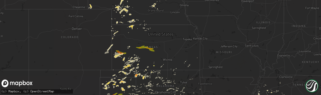
Hail Map in Kansas on June 6, 2014
The weather event in Kansas on June 6, 2014 includes Hail map. 20 states and 973 cities were impacted and suffered possible damage. The total estimated number of properties impacted is 14,334.
Want more than just the map?
Turn this storm into a full workflow.
- Owner + property data so you know who to knock
- OnDemand branded weather history reports to win the "did we even have hail?" argument
- RoofTrace estimate so reps stop guessing numbers at the door
Bought this map? Upgrade within 7 days and we'll credit the $230. (10-15 min setup call)
Hail
14,334
Estimated number of impacted properties by a 1.00" hail or larger2,078
Estimated number of impacted properties by a 1.75" hail or larger0
Estimated number of impacted properties by a 2.50" hail or largerStorm reports in Kansas
Kansas
| Date | Description |
|---|---|
| 06/06/20146:59 PM CDT | Multiple sightings... Moving east. |
| 06/06/20146:58 PM CDT | Spotter reported brief small cone tornado less than one mile west of deerfield. |
| 06/06/20146:47 PM CDT | A local report indicates a tornado near 5 W DEERFIELD |
| 06/06/20146:29 PM CDT | A local report indicates 1.00 inch wind near 4 N GOODLAND |
| 06/06/20146:01 PM CDT | A local report indicates 1.00 inch wind near 8 SSE SYRACUSE |
| 06/06/20146:00 PM CDT | The hail size reported varied from dime to quarter size. |
| 06/06/20145:35 PM CDT | Quarter size hail was covering the ground. |
| 06/06/20145:05 PM CDT | A local report indicates 1.25 inch wind near 10 SSE SYRACUSE |
| 06/06/20144:55 PM CDT | A local report indicates 1.00 inch wind near 4 SW ENSIGN |
| 06/06/20144:12 PM CDT | A local report indicates 1.00 inch wind near 4 NNW KISMET |
| 06/06/20144:05 PM CDT | A local report indicates 1.75 inch wind near 10 WNW KISMET |
| 06/06/20143:58 PM CDT | A local report indicates 1.00 inch wind near 7 NW HAYNE |
| 06/05/201410:07 PM CDT | 55-60 mph estimated winds with very heavy rain. |
| 06/05/20149:32 PM CDT | A local report indicates 60 MPH wind near LOGAN |
| 06/05/20149:30 PM CDT | A local report indicates 1.00 inch wind near 4 W WAKEENEY |
| 06/05/20148:58 PM CDT | A local report indicates 60 MPH wind near 4 S GOVE |
| 06/05/20148:56 PM CDT | Lots of blowing dust. |
| 06/05/20148:50 PM CDT | A local report indicates 70 MPH wind near 4 SE MEADE |
| 06/05/20148:45 PM CDT | A local report indicates 1.50 inch wind near DODGE CITY |
| 06/05/20148:36 PM CDT | Approximately 10 power poles blown down at highway 56 and 17 road. |
| 06/05/20148:30 PM CDT | Semi trailer blown over on highway 83. Time estimated from radar. |
| 06/05/20148:24 PM CDT | A local report indicates 1.50 inch wind near PLAINS CITY |
| 06/05/20148:15 PM CDT | A local report indicates 60 MPH wind near 3 S CIMARRON |
| 06/05/20148:15 PM CDT | A local report indicates 65 MPH wind near 5 NE WINONA |
| 06/05/20148:08 PM CDT | A local report indicates 70 MPH wind near 4 SW ENSIGN |
| 06/05/20148:02 PM CDT | A local report indicates 78 MPH wind near 8 S INGALLS |
| 06/05/20147:58 PM CDT | A local report indicates 60 MPH wind near COLBY |
| 06/05/20147:55 PM CDT | Wind gust of 58 mph reported from the liberal municipal airport asos. |
| 06/05/20147:55 PM CDT | Lbl awos 070055z 33026g50kt. |
| 06/05/20147:50 PM CDT | Wind gust speed was estimated 60 to 70 mph driving along highway 50 at this location. |
| 06/05/20147:35 PM CDT | A local report indicates 60 MPH wind near ATWOOD |
| 06/05/20147:26 PM CDT | A local report indicates 58 MPH wind near 4 N ATWOOD |
| 06/05/20147:24 PM CDT | A local report indicates 79 MPH wind near 2 N ATWOOD |
| 06/05/20147:20 PM CDT | Large tree branches and several trees down in goodland. |
| 06/05/20147:15 PM CDT | A local report indicates 62 MPH wind near 4 W GOODLAND |
| 06/05/20147:15 PM CDT | A local report indicates 60 MPH wind near 6 NW HICKOK |
| 06/05/20147:14 PM CDT | Time estimated from radar. Shop in south goodland completely destroyed. |
| 06/05/20147:13 PM CDT | A local report indicates 71 MPH wind near GOODLAND |
| 06/05/20147:06 PM CDT | Several trees blown down in the city of ulysses. |
| 06/05/20147:01 PM CDT | A local report indicates 59 MPH wind near BIRD CITY |
All States Impacted by Hail Map on June 6, 2014
Cities Impacted by Hail Map on June 6, 2014
- Wray, CO
- Idalia, CO
- Dalhart, TX
- Norcatur, KS
- Oberlin, KS
- La Loma, NM
- Smithville, GA
- Sunray, TX
- Saint Paul, NE
- Dannebrog, NE
- West Union, SC
- Holly, CO
- Stratton, CO
- Vona, CO
- Stratton, NE
- Loco, OK
- Duncan, OK
- Graham, OK
- Healdton, OK
- Fernandina Beach, FL
- Callahan, FL
- Pampa, TX
- Bushnell, NE
- Spearman, TX
- Stinnett, TX
- Stratford, TX
- Bison, OK
- Douglas, OK
- Lowndesboro, AL
- Hope Hull, AL
- Montgomery, AL
- Palestine, AR
- Muscle Shoals, AL
- Hollis, OK
- Burlington, CO
- Raton, NM
- Trinchera, CO
- Rockledge, GA
- East Dublin, GA
- Adrian, GA
- Cody, NE
- Nenzel, NE
- Owatonna, MN
- Waseca, MN
- Shattuck, OK
- Laverne, OK
- Elsie, NE
- Wallace, NE
- Chandler, OK
- Lookeba, OK
- Tuthill, SD
- Merriman, NE
- Jennings, KS
- Madill, OK
- Crookston, NE
- Waterford, MS
- Como, MS
- Lagrange, GA
- Arlington, TN
- Miami, TX
- Canadian, TX
- Ellabell, GA
- Enid, OK
- Wagon Mound, NM
- Kensington, KS
- West Blocton, AL
- Kimball, NE
- Holyoke, CO
- Haxtun, CO
- Henderson, TN
- Cherryvale, KS
- Sublette, KS
- Grady, NM
- Hennepin, OK
- Denmark, TN
- Jackson, TN
- Mooreland, OK
- Cullman, AL
- Bamberg, SC
- Solano, NM
- Gruver, TX
- Mosquero, NM
- Medicine Lodge, KS
- Sharon, KS
- Turrell, AR
- Earle, AR
- Tyronza, AR
- Cope, SC
- Branchville, SC
- Smoaks, SC
- Lodge, SC
- Ruffin, SC
- Vega, TX
- Macclenny, FL
- Glen Saint Mary, FL
- Sanderson, FL
- Eclectic, AL
- Lamar, AR
- Wellston, OK
- Rogersville, AL
- Healy, KS
- Borger, TX
- Skellytown, TX
- Jasper, FL
- Burbank, OK
- Akron, CO
- Marion Junction, AL
- Uniontown, AL
- Marion, AL
- Pell City, AL
- Riverside, AL
- Weston, CO
- Boncarbo, CO
- Trinidad, CO
- Weatherford, OK
- Keystone, NE
- Wellington, TX
- Larkspur, CO
- Jackson, GA
- Lamar, MO
- Calera, AL
- Texola, OK
- Erick, OK
- Shamrock, TX
- Brinkley, AR
- Philadelphia, MS
- Haigler, NE
- Smithville, OK
- Watson, OK
- Lexington, MS
- Elida, NM
- Hilliard, FL
- Clanton, AL
- Jemison, AL
- Thorsby, AL
- Verbena, AL
- Mullen, NE
- Comanche, OK
- Walters, OK
- Kit Carson, CO
- Syracuse, KS
- Kendall, KS
- Dodge City, KS
- New Raymer, CO
- Ada, OK
- Kersey, CO
- Hector, AR
- Dover, AR
- Maxwell, NM
- Balko, OK
- Stoneham, CO
- Padroni, CO
- Merino, CO
- Powhatan, AR
- Black Rock, AR
- Iliff, CO
- Crook, CO
- Sedgwick, CO
- Seneca, SC
- Orchard, CO
- Freedom, OK
- Beaver, OK
- Buffalo, OK
- Follett, TX
- May, OK
- Peetz, CO
- Hogansville, GA
- Grantville, GA
- North Platte, NE
- Plains, KS
- Linden, TN
- Decaturville, TN
- Kress, TX
- Paxton, NE
- Ogallala, NE
- Yuma, CO
- Cambridge, NE
- Bartley, NE
- Live Oak, FL
- Keysville, GA
- Letohatchee, AL
- Senoia, GA
- Gay, GA
- Montevallo, AL
- Brierfield, AL
- Alabaster, AL
- Helena, AL
- Medon, TN
- Toone, TN
- Hodges, AL
- Vina, AL
- Ainsworth, NE
- Briggsdale, CO
- Sarah, MS
- Julesburg, CO
- Gordon, NE
- Arapahoe, NE
- Edison, NE
- Pryor, OK
- Claremore, OK
- Hazen, AR
- Pueblo, CO
- Avondale, CO
- Cimarron, KS
- Madrid, NE
- Guntersville, AL
- Albertville, AL
- Rosston, OK
- Boelus, NE
- Kennedy, AL
- Hershey, NE
- Jet, OK
- Elk River, MN
- Ensign, KS
- Montezuma, KS
- Max, NE
- Aguilar, CO
- Longdale, OK
- Nash, OK
- Okmulgee, OK
- Beggs, OK
- Brule, NE
- Crawfordsville, AR
- Hartley, TX
- Wood Lake, NE
- Jacksonville, AL
- Hyannis, NE
- Carrier, OK
- Goltry, OK
- Belzoni, MS
- Ardmore, OK
- Wilson, OK
- Jacksonville, GA
- Stratford, OK
- Kilgore, NE
- Sutherland, NE
- Tryon, NE
- Louisville, AL
- Proctor, AR
- Lawrenceburg, TN
- Woodward, OK
- Fort Supply, OK
- Anniston, AL
- Piedmont, AL
- McRae Helena, GA
- Luray, TN
- Mount Vernon, GA
- Ovid, CO
- Hugoton, KS
- Liberal, KS
- Satanta, KS
- Meade, KS
- Kismet, KS
- Alexander City, AL
- House, NM
- Melrose, NM
- Linn Grove, IA
- Corona, NM
- Bosler, WY
- Rock River, WY
- Hooker, OK
- Stuart, OK
- Chapman, NE
- Saint Edward, NE
- Fullerton, NE
- Forgan, OK
- Lakin, KS
- Northport, AL
- Berry, AL
- Stilwell, OK
- Weleetka, OK
- Lorenzo, TX
- Ralls, TX
- Otis, CO
- Rockville, NE
- Johnstown, NE
- Valentine, NE
- Saint Francis, SD
- Fairview, OK
- Chester, OK
- Clayton, NM
- Kirwin, KS
- Ulysses, KS
- Garden City, KS
- Howells, NE
- Dodson, TX
- Childress, TX
- Butler, GA
- Mauk, GA
- Noble, OK
- Norman, OK
- Wright, KS
- Edson, KS
- Goodland, KS
- Redfield, KS
- Weskan, KS
- Tishomingo, OK
- Milburn, OK
- Saint Francis, KS
- Argonia, KS
- Freeport, KS
- Yulee, FL
- Sheridan Lake, CO
- Willow, OK
- Vinson, OK
- Mangum, OK
- Dublin, GA
- Rentz, GA
- Davis, OK
- Benkelman, NE
- Hartman, AR
- Taloga, OK
- Marlow, OK
- Crawford, OK
- Soperton, GA
- Tarrytown, GA
- Atoka, OK
- Pittsburg, OK
- Ellendale, MN
- Goodwell, OK
- Beulah, CO
- Curtis, NE
- Eva, AL
- Vinemont, AL
- Falkville, AL
- Cheyenne, OK
- Gate, OK
- Ford, KS
- De Soto, GA
- Leesburg, GA
- Perryton, TX
- Bird City, KS
- Washington, OK
- Blanchard, OK
- Coleman, OK
- Clovis, NM
- Ingalls, KS
- Lebanon, NE
- Colorado Springs, CO
- Yoder, CO
- Minneola, KS
- Double Springs, AL
- Albany, GA
- Springview, NE
- Union Springs, AL
- Hennessey, OK
- Marshall, OK
- Idalou, TX
- Slaton, TX
- Fort Stewart, GA
- Cedar, KS
- Gaylord, KS
- Athol, KS
- Hugo, CO
- Marianna, AR
- Moro, AR
- Parks, NE
- Carpenter, WY
- Hereford, CO
- Grover, CO
- Guymon, OK
- Bethune, CO
- Spencer, OK
- Jones, OK
- Arcadia, OK
- Edmond, OK
- Oklahoma City, OK
- Luther, OK
- Cimarron, NM
- Stamford, NE
- Riceboro, GA
- Seiling, OK
- Logan, NM
- Tucumcari, NM
- Marietta, OK
- Camden, AL
- Alberta, AL
- Putnam, OK
- Leedey, OK
- Mathews, AL
- Burns, WY
- Alva, OK
- Sawyerville, AL
- Forkland, AL
- Boligee, AL
- Cherokee, OK
- Pawnee, OK
- Turpin, OK
- Plainview, TX
- Mill Creek, OK
- Mannsville, OK
- Hinton, OK
- Cordele, GA
- McCook, NE
- Cheyenne, WY
- Brookwood, AL
- Adger, AL
- Perryville, AR
- Causey, NM
- Waukomis, OK
- Tyrone, OK
- Gray, GA
- Macon, GA
- Copeland, KS
- Booker, TX
- Wheeler, TX
- Sparks, OK
- Walhalla, SC
- Paoli, CO
- Rogers, NM
- Sulphur, OK
- Hayes Center, NE
- Olar, SC
- Perry, OK
- Tallassee, AL
- Roy, NM
- Amistad, NM
- Nara Visa, NM
- Fort Smith, AR
- Woodrow, CO
- Fay, OK
- Martin, SD
- Clayton, OK
- Pike Road, AL
- Cecil, AL
- Byromville, GA
- Vienna, GA
- Booneville, AR
- Morse, TX
- Elmore City, OK
- Leary, GA
- Deerfield, KS
- Louisville, MS
- Channing, TX
- Henryetta, OK
- Anoka, MN
- Pitts, GA
- Adair, OK
- Stapleton, NE
- Altus, AR
- Farwell, NE
- Ratliff City, OK
- Wynnewood, OK
- Springer, OK
- Dougherty, OK
- Lone Grove, OK
- Ringling, OK
- Colony, OK
- Corn, OK
- Hydro, OK
- Dumas, TX
- Gordo, AL
- Aliceville, AL
- Eutaw, AL
- Lithonia, GA
- Sylacauga, AL
- Talladega, AL
- Savannah, GA
- Indianola, NE
- Jerusalem, AR
- Claxton, GA
- Byhalia, MS
- Glencoe, OK
- Tutwiler, MS
- Charleston, MS
- Sumner, MS
- Elba, NE
- Grant, NE
- Castle Rock, CO
- West, MS
- Fredonia, KS
- Leslie, GA
- Eatonton, GA
- Monticello, GA
- Haddock, GA
- Safford, AL
- Rush, CO
- Statenville, GA
- Lake Park, GA
- Tuscaloosa, AL
- Mount Hope, AL
- Stillwater, OK
- Orlando, OK
- Shidler, OK
- Ripley, TN
- Pauls Valley, OK
- Covington, TN
- Briscoe, TX
- Lexington, AL
- Lamar, CO
- Elbert, CO
- Franktown, CO
- Ashland, KS
- Englewood, KS
- Tribune, KS
- Pritchett, CO
- Glenwood, GA
- Vaughn, NM
- Waynoka, OK
- Batesville, AR
- Williamson, GA
- Concord, GA
- Gordon, GA
- Homerville, GA
- Lake City, KS
- Saint Simons Island, GA
- Lexington, OK
- Wanette, OK
- Bolivar, TN
- Greenville, AL
- Fort Deposit, AL
- Pine Apple, AL
- Minter, AL
- Forest Home, AL
- Hayneville, AL
- Nicollet, MN
- Hickory Ridge, AR
- Custer City, OK
- Rhine, GA
- Yemassee, SC
- Seabrook, SC
- Islandton, SC
- Haswell, CO
- Brent, AL
- Grenada, MS
- Stonewall, OK
- Roff, OK
- Hereford, TX
- Friona, TX
- Summerfield, TX
- Oakwood, OK
- Whitman, NE
- Holcomb, KS
- Karval, CO
- Mcalister, NM
- Selma, AL
- Wellfleet, NE
- Dickens, NE
- Ocate, NM
- Jetmore, KS
- Marshallville, GA
- Harris, MN
- Argyle, GA
- Colt, AR
- Wynne, AR
- Pulaski, GA
- Metter, GA
- Register, GA
- Sterling, CO
- Alcova, WY
- Arapahoe, CO
- Naponee, NE
- Fayetteville, AR
- Waycross, GA
- Tecumseh, OK
- Banks, AL
- Foster, OK
- Crescent, OK
- Meadow Grove, NE
- Pierce, NE
- Norfolk, NE
- Okemah, OK
- Eufaula, AL
- Lambert, MS
- Bryceville, FL
- Greenville, MS
- Sheldon, MO
- Saint George, GA
- Paoli, OK
- Wayne, OK
- Milledgeville, GA
- Lubbock, TX
- Fort Sumner, NM
- Dexter, GA
- Champion, NE
- Alpine, AL
- Fort Morgan, CO
- Vance, AL
- Tumbling Shoals, AR
- Ida, AR
- Drasco, AR
- Wrightsville, GA
- Kite, GA
- Madison, NE
- Ridgeland, WI
- Wheeler, WI
- Maysville, OK
- Dardanelle, AR
- Delaware, AR
- Wilmore, KS
- Ozark, AR
- Forrest City, AR
- Tulia, TX
- Spearville, KS
- Geary, OK
- Sweetwater, OK
- Yale, OK
- La Crescent, MN
- Millport, AL
- Silver City, MS
- Maywood, NE
- Maxwell, NE
- Moorefield, NE
- Warrenton, GA
- Blakely, GA
- Haynes, AR
- Jacksonville, FL
- Marked Tree, AR
- Waynesboro, TN
- Brunswick, GA
- Rochelle, GA
- Huntsville, AR
- Witter, AR
- Conyers, GA
- Covington, GA
- Oxford, GA
- Batesville, MS
- Cuba, AL
- Scott City, KS
- Oakfield, GA
- Sylvester, GA
- Morrilton, AR
- Tillatoba, MS
- Scobey, MS
- Abbeville, AL
- Georgetown, GA
- Holcomb, MS
- Toomsboro, GA
- McIntyre, GA
- Yeso, NM
- Fowler, KS
- Equality, AL
- Rockford, AL
- Cove, AR
- Wickes, AR
- McCrory, AR
- Fitzpatrick, AL
- Jasper, AL
- Conway Springs, KS
- Rogersville, MO
- Arapaho, OK
- Thomas, OK
- Newkirk, OK
- Maple City, KS
- Trenton, SC
- Pulaski, TN
- Glennville, GA
- Milan, GA
- Cedar Rapids, NE
- Elba, AL
- Glenwood, AL
- Bath Springs, TN
- Medford, MN
- New Richland, MN
- Saint Paul, MN
- Lakeville, MN
- Wolbach, NE
- Titus, AL
- Cecil, AR
- Elgin, OK
- Hillsboro, GA
- Elk City, OK
- Brundidge, AL
- Clayton, AL
- Liberal, MO
- Mindenmines, MO
- Sentinel, OK
- Lone Wolf, OK
- Carter, OK
- Tuskegee, AL
- Blanco, OK
- Vilonia, AR
- El Paso, AR
- Earlsboro, OK
- Seminole, OK
- Eads, TN
- Brighton, TN
- Mason, TN
- Memphis, TN
- Cordova, TN
- Arkansas City, KS
- Stroud, OK
- Depew, OK
- London, AR
- Burlington, OK
- Beech Bluff, TN
- San Jon, NM
- Baconton, GA
- Portia, AR
- Trenton, TN
- Deer Trail, CO
- Jonesboro, AR
- Bono, AR
- Quitman, GA
- Pierceville, KS
- Norton, KS
- Coldwater, MS
- Hernando, MS
- McAlpin, FL
- Thomasville, AL
- Oakman, AL
- Townley, AL
- Waverly, TN
- Walterboro, SC
- Hartselle, AL
- Abbeville, GA
- Pineview, GA
- Sayre, OK
- Lindsay, OK
- Bradley, OK
- Ehrhardt, SC
- Tennille, GA
- Selden, KS
- Lonoke, AR
- Hackett, AR
- Cameron, OK
- Happy, TX
- Wayside, TX
- Camargo, OK
- Vici, OK
- Anthony, KS
- Scranton, AR
- Knoxville, AR
- Iuka, MS
- Albion, NE
- Troy, AL
- Moultrie, GA
- Norman Park, GA
- Phillips, NE
- Prague, OK
- Dundee, MS
- Grand Island, NE
- Hale Center, TX
- Tuskegee Institute, AL
- Sturgis, MS
- Orrville, AL
- Paden, OK
- Boley, OK
- Castle, OK
- Arabi, GA
- Seibert, CO
- Flagler, CO
- Reagan, TN
- Noxapater, MS
- Fargo, OK
- Jacksonville, AR
- Rosalie, NE
- Pine Bluffs, WY
- Paris, AR
- Chauncey, GA
- Sledge, MS
- Boone, CO
- Twin City, GA
- Swainsboro, GA
- Pep, NM
- Portales, NM
- Middleburg, FL
- Alma, NE
- Olive Branch, MS
- Benedict, KS
- Manchester, OK
- Wakita, OK
- Weldona, CO
- Augusta, AR
- Courtland, AL
- Moulton, AL
- Hinesville, GA
- Reydon, OK
- Lepanto, AR
- Platte Center, NE
- Long Pine, NE
- Jennings, FL
- Mclean, TX
- Claude, TX
- Saint Libory, NE
- Rich Hill, MO
- Hume, MO
- Akron, AL
- Gallion, AL
- Byars, OK
- Town Creek, AL
- Bristow, OK
- Walsenburg, CO
- Levelland, TX
- Newnan, GA
- Sharpsburg, GA
- Cherokee, IA
- Atkins, AR
- Danville, AL
- Hanna, WY
- Fayette, AL
- Brady, NE
- Palisade, NE
- Mayo, FL
- Wyoming, MN
- Mcalester, OK
- Woodstock, AL
- Madison, AL
- Lumpkin, GA
- Pottsville, AR
- Russellville, AR
- Scotts Hill, TN
- Wapanucka, OK
- Statesboro, GA
- Ringwood, OK
- Helena, OK
- Grove Hill, AL
- Dickinson, AL
- Fowler, CO
- Porum, OK
- Rutledge, AL
- Phil Campbell, AL
- Amorita, OK
- Mena, AR
- Okeene, OK
- Hitchcock, OK
- Kingfisher, OK
- Red Banks, MS
- Dighton, KS
- Center Ridge, AR
- Cleveland, AR
- Gill, CO
- Cascilla, MS
- Amherst, TX
- Enochs, TX
- Ludowici, GA
- Allenhurst, GA
- Wetumpka, AL
- Duck Hill, MS
- Carlsbad, NM
- Canute, OK
- Humphrey, NE
- Silverton, TX
- West Point, NE
- Watonga, OK
- Canton, OK
- Weaver, AL
- Phillipsburg, KS
- Quincy, FL
- Smith Center, KS
- Walsh, CO
- Cushing, OK
- Limon, CO
- Townsend, GA
- Sardis, MS
- Hanceville, AL
- Salem, AL
- Alamo, TN
- Friendship, TN
- Florence, AL
- Little Rock, AR
- Du Pont, GA
- Somerville, AL
- Dudley, GA
- Chester, GA
- Morton, TX
- Dennis, KS
- Autaugaville, AL
- Peyton, CO
- Brush, CO
- Snyder, CO
- Hillrose, CO
- Centreville, AL
- Lawley, AL
- Brooks, GA
- Franklin, GA
- Sudan, TX
- Maple, TX
- Dawson, GA
- Loving, NM
- Cadwell, GA
- Springfield, CO
- Sedalia, CO
- Fitzhugh, OK
- Norway, SC
- Meno, OK
- Broken Arrow, OK
- Dimmitt, TX
- Oxford, MS
- Cleveland, MS
- Merigold, MS
- Isabel, KS
- Pinson, TN
- Winona, MS
- McCarley, MS
- Arnett, OK
- Elkhart, KS
- Tyler, AL
- Epes, AL
- Greensboro, AL
- Marks, MS
- Clopton, AL
- Newville, AL
- Dexter, KS
- Rosemount, MN
- Burnsville, MN
- Coalgate, OK
- Union, MS
- Notasulga, AL
- Germantown, TN
- Toomsuba, MS
- Bancroft, NE
- Fairfax, OK
- Beaver City, NE
- Almena, KS
- Hillsboro, AL
- Granite, OK
- Glade, KS
- Elmore, AL
- Deatsville, AL
- Trinity, AL
- Booneville, MS
- Carthage, MS
- Bradford, AR
- Elkmont, AL
- Venango, NE
- Republican City, NE
- Newbern, AL
- Compton, AR
- Hollywood, SC
- Adams Run, SC
- Wardville, OK
- Drew, MS
- Ruleville, MS
- Wilsonville, NE
- Monroe, GA
- Loganville, GA
- Canyon, TX
- Groom, TX
- Amarillo, TX
- Wildorado, TX
- Panhandle, TX
- Alexander, KS
- Bazine, KS
- Leoti, KS
- Bison, KS
- Albert, KS
- Rush Center, KS
- Otis, KS
- Great Bend, KS
- Nekoma, KS
- Hoisington, KS
- La Crosse, KS
- Olmitz, KS
- Ellinwood, KS
- McCracken, KS
- Hudson, KS
- Ness City, KS
- Farmville, NC
- Greenville, NC
- Chocowinity, NC
- Blounts Creek, NC
- Aurora, NC
- Edward, NC
- Clinton, NC
- La Grange, NC
- Snow Hill, NC
- Newport, NC
- Swansboro, NC
- Stella, NC
- Emerald Isle, NC
- Granby, MO
- Pierce City, MO
- Stark City, MO
- Neosho, MO
- Mount Vernon, MO
- Everton, MO
- Ash Grove, MO
- Miller, MO
- Bois D Arc, MO
- Halltown, MO
- Willard, MO
- Stotts City, MO


