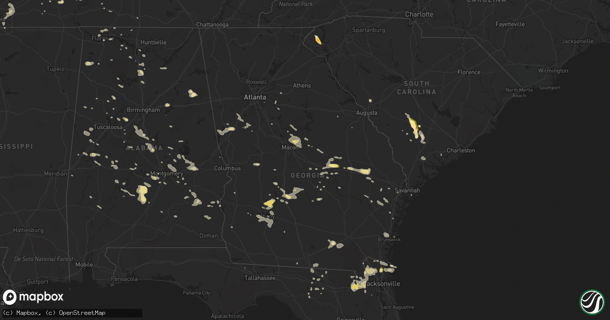
Hail Map in Georgia on June 6, 2014
Get this storm
June 6 map
$229
one time, instant access
Download today. No call, no setup
Keep the $229
Bought the map and want the full workflow? Apply the entire $229 to a subscription within 7 days. None of it is wasted.
Every map, not just this one
This buys you this map. Subscription and you get every map we run, in the markets you choose from a few cities to whole states to nationwide. Plus real-time alerts the moment a storm fires.
Contact data
Name, contact info, occupancy, even credit band for addresses in the footprint. You go from where it hit to who to call.
Become the source they trust
Unlimited branding weather history reports on demand. You already have the documented answer ready for the property owner, and you are the one who showed up with it.
Property data and RoofTrace estimates
Pull up any address you have got, its value and the exact code rules for that jurisdiction, straight from One Click Code. Then RoofTrace estimates the squares, pitch, and roof value, priced the way you price.
Storm reports in Georgia
Georgia
| Date | Description |
|---|---|
| 06/06/20146:52 PM CDT | Tree down on a power line along batts road |
| 06/06/20146:43 PM CDT | Tree down on 2 unoccupied vehicles along royal oak drive. |
| 06/06/20146:39 PM CDT | A couple of trees were reported down on the east side of the county. |
| 06/06/20146:38 PM CDT | Tree down on the leroy coffer highway. |
| 06/06/20146:30 PM CDT | Several large limbs down. |
| 06/06/20146:18 PM CDT | Dooly county sheriff reported a couple of trees down in the vienna area. |
| 06/06/20146:17 PM CDT | 2 trees downed. |
| 06/06/20146:05 PM CDT | Numerous large trees down and across roads in statesboro. |
| 06/06/20146:00 PM CDT | 15 to 20 large trees down along a line from register to statesboro to brooklet. |
| 06/06/20145:38 PM CDT | Numerous trees down in and around the city of metter. |
| 06/06/20145:36 PM CDT | 2 trees down on highway 57 south. |
| 06/06/20145:30 PM CDT | Flint river 911 call center relayed a report of a couple of trees down in the marshallville area. |
| 06/06/20145:24 PM CDT | Emanuel county 911 relayed a report of numerous trees down across southern portions of the county. Trees were down in nunez swainsboro stillmore and norristown junction |
| 06/06/20145:09 PM CDT | Multiple trees down in adrian. Report from amatuer radio. |
| 06/06/20144:55 PM CDT | A trained spotter reports nickel to quarter sized hail. |
| 06/06/20144:47 PM CDT | Johnson county ema relayed a report of 20 trees down and a few houses with shingle damage from the storm. Time is based on radar. |
| 06/06/20144:32 PM CDT | Tree reported down on a house in toomsboro. Several trees also reported down on hwy 57 on the wilkinson and washington county line. |
| 06/06/20144:30 PM CDT | Laurens 911 relayed a report of quarter sized hail. |
| 06/06/20144:12 PM CDT | Meriwether 911 relayed a report of a couple of trees down in far nw part of the county along with several power outages. |
| 06/06/20143:50 PM CDT | Troup county 911 relayed a report of several trees down in the hogansville area. A tree was reported downed on a house between hogansville and lagrange. |
| 06/06/20143:45 PM CDT | Jones county 911 relayed a report of 3 trees down across the county. |
| 06/06/20142:56 PM CDT | Em relayed a report of two trees down in the city. |
| 06/05/201410:45 PM CDT | Tree down in clyattville |
| 06/05/201410:40 PM CDT | 7 locations with trees down in the city of valdosta. Power lines also down |
| 06/05/201410:38 PM CDT | Tree down along highway 84 |
| 06/05/201410:35 PM CDT | Several trees down across brooks county |
| 06/05/201410:16 PM CDT | Trees blown down. |
| 06/05/201410:00 PM CDT | Numerous trees down across the county. |
| 06/05/20149:51 PM CDT | Power lines down around tifton |
| 06/05/20149:50 PM CDT | Couple of trees down near ochlocknee |
| 06/05/20149:50 PM CDT | Couple of trees down near coolidge |
| 06/05/20149:45 PM CDT | Numerous trees down across the county |
| 06/05/20149:30 PM CDT | Multiple reports of trees and power lines down across mitchell county. |
| 06/05/20149:22 PM CDT | Power lines down in the city of colquitt. |
| 06/05/20148:50 PM CDT | A few trees down across the county...public also reported power lines down per scanner feed |
| 06/05/20148:30 PM CDT | Two large trees felled in the city of albany. |
| 06/05/20147:39 PM CDT | Tree in road at ford avenue and grove point. |
| 06/05/20147:39 PM CDT | Tree down jimmy deloach parkway at farm lake drive. |
| 06/05/20147:26 PM CDT | A couple of trees down just east of 75 near arabi. |
| 06/05/20147:20 PM CDT | Large tree felled on laramore road. |
| 06/05/20147:19 PM CDT | Tree down on buckhalter road near ogeechee road. |
| 06/05/20147:15 PM CDT | Large tree felled on mossy dell road. |
| 06/05/20147:14 PM CDT | Tree down on bonny bridge road near highway 25. |
All States Impacted by Hail Map on June 6, 2014
Cities Impacted by Hail Map on June 6, 2014
- Wray, CO
- Idalia, CO
- Dalhart, TX
- Norcatur, KS
- Oberlin, KS
- La Loma, NM
- Smithville, GA
- Sunray, TX
- Saint Paul, NE
- Dannebrog, NE
- West Union, SC
- Holly, CO
- Stratton, CO
- Vona, CO
- Stratton, NE
- Loco, OK
- Duncan, OK
- Graham, OK
- Healdton, OK
- Fernandina Beach, FL
- Callahan, FL
- Pampa, TX
- Bushnell, NE
- Spearman, TX
- Stinnett, TX
- Stratford, TX
- Bison, OK
- Douglas, OK
- Lowndesboro, AL
- Hope Hull, AL
- Montgomery, AL
- Palestine, AR
- Muscle Shoals, AL
- Hollis, OK
- Burlington, CO
- Raton, NM
- Trinchera, CO
- Rockledge, GA
- East Dublin, GA
- Adrian, GA
- Cody, NE
- Nenzel, NE
- Owatonna, MN
- Waseca, MN
- Shattuck, OK
- Laverne, OK
- Elsie, NE
- Wallace, NE
- Chandler, OK
- Lookeba, OK
- Tuthill, SD
- Merriman, NE
- Jennings, KS
- Madill, OK
- Crookston, NE
- Waterford, MS
- Como, MS
- Lagrange, GA
- Arlington, TN
- Miami, TX
- Canadian, TX
- Ellabell, GA
- Enid, OK
- Wagon Mound, NM
- Kensington, KS
- West Blocton, AL
- Kimball, NE
- Holyoke, CO
- Haxtun, CO
- Henderson, TN
- Cherryvale, KS
- Sublette, KS
- Grady, NM
- Hennepin, OK
- Denmark, TN
- Jackson, TN
- Mooreland, OK
- Cullman, AL
- Bamberg, SC
- Solano, NM
- Gruver, TX
- Mosquero, NM
- Medicine Lodge, KS
- Sharon, KS
- Turrell, AR
- Earle, AR
- Tyronza, AR
- Cope, SC
- Branchville, SC
- Smoaks, SC
- Lodge, SC
- Ruffin, SC
- Vega, TX
- Macclenny, FL
- Glen Saint Mary, FL
- Sanderson, FL
- Eclectic, AL
- Lamar, AR
- Wellston, OK
- Rogersville, AL
- Healy, KS
- Borger, TX
- Skellytown, TX
- Jasper, FL
- Burbank, OK
- Akron, CO
- Marion Junction, AL
- Uniontown, AL
- Marion, AL
- Pell City, AL
- Riverside, AL
- Weston, CO
- Boncarbo, CO
- Trinidad, CO
- Weatherford, OK
- Keystone, NE
- Wellington, TX
- Larkspur, CO
- Jackson, GA
- Lamar, MO
- Calera, AL
- Texola, OK
- Erick, OK
- Shamrock, TX
- Brinkley, AR
- Philadelphia, MS
- Haigler, NE
- Smithville, OK
- Watson, OK
- Lexington, MS
- Elida, NM
- Hilliard, FL
- Clanton, AL
- Jemison, AL
- Thorsby, AL
- Verbena, AL
- Mullen, NE
- Comanche, OK
- Walters, OK
- Kit Carson, CO
- Syracuse, KS
- Kendall, KS
- Dodge City, KS
- New Raymer, CO
- Ada, OK
- Kersey, CO
- Hector, AR
- Dover, AR
- Maxwell, NM
- Balko, OK
- Stoneham, CO
- Padroni, CO
- Merino, CO
- Powhatan, AR
- Black Rock, AR
- Iliff, CO
- Crook, CO
- Sedgwick, CO
- Seneca, SC
- Orchard, CO
- Freedom, OK
- Beaver, OK
- Buffalo, OK
- Follett, TX
- May, OK
- Peetz, CO
- Hogansville, GA
- Grantville, GA
- North Platte, NE
- Plains, KS
- Linden, TN
- Decaturville, TN
- Kress, TX
- Paxton, NE
- Ogallala, NE
- Yuma, CO
- Cambridge, NE
- Bartley, NE
- Live Oak, FL
- Keysville, GA
- Letohatchee, AL
- Senoia, GA
- Gay, GA
- Montevallo, AL
- Brierfield, AL
- Alabaster, AL
- Helena, AL
- Medon, TN
- Toone, TN
- Hodges, AL
- Vina, AL
- Ainsworth, NE
- Briggsdale, CO
- Sarah, MS
- Julesburg, CO
- Gordon, NE
- Arapahoe, NE
- Edison, NE
- Pryor, OK
- Claremore, OK
- Hazen, AR
- Pueblo, CO
- Avondale, CO
- Cimarron, KS
- Madrid, NE
- Guntersville, AL
- Albertville, AL
- Rosston, OK
- Boelus, NE
- Kennedy, AL
- Hershey, NE
- Jet, OK
- Elk River, MN
- Ensign, KS
- Montezuma, KS
- Max, NE
- Aguilar, CO
- Longdale, OK
- Nash, OK
- Okmulgee, OK
- Beggs, OK
- Brule, NE
- Crawfordsville, AR
- Hartley, TX
- Wood Lake, NE
- Jacksonville, AL
- Hyannis, NE
- Carrier, OK
- Goltry, OK
- Belzoni, MS
- Ardmore, OK
- Wilson, OK
- Jacksonville, GA
- Stratford, OK
- Kilgore, NE
- Sutherland, NE
- Tryon, NE
- Louisville, AL
- Proctor, AR
- Lawrenceburg, TN
- Woodward, OK
- Fort Supply, OK
- Anniston, AL
- Piedmont, AL
- McRae Helena, GA
- Luray, TN
- Mount Vernon, GA
- Ovid, CO
- Hugoton, KS
- Liberal, KS
- Satanta, KS
- Meade, KS
- Kismet, KS
- Alexander City, AL
- House, NM
- Melrose, NM
- Linn Grove, IA
- Corona, NM
- Bosler, WY
- Rock River, WY
- Hooker, OK
- Stuart, OK
- Chapman, NE
- Saint Edward, NE
- Fullerton, NE
- Forgan, OK
- Lakin, KS
- Northport, AL
- Berry, AL
- Stilwell, OK
- Weleetka, OK
- Lorenzo, TX
- Ralls, TX
- Otis, CO
- Rockville, NE
- Johnstown, NE
- Valentine, NE
- Saint Francis, SD
- Fairview, OK
- Chester, OK
- Clayton, NM
- Kirwin, KS
- Ulysses, KS
- Garden City, KS
- Howells, NE
- Dodson, TX
- Childress, TX
- Butler, GA
- Mauk, GA
- Noble, OK
- Norman, OK
- Wright, KS
- Edson, KS
- Goodland, KS
- Redfield, KS
- Weskan, KS
- Tishomingo, OK
- Milburn, OK
- Saint Francis, KS
- Argonia, KS
- Freeport, KS
- Yulee, FL
- Sheridan Lake, CO
- Willow, OK
- Vinson, OK
- Mangum, OK
- Dublin, GA
- Rentz, GA
- Davis, OK
- Benkelman, NE
- Hartman, AR
- Taloga, OK
- Marlow, OK
- Crawford, OK
- Soperton, GA
- Tarrytown, GA
- Atoka, OK
- Pittsburg, OK
- Ellendale, MN
- Goodwell, OK
- Beulah, CO
- Curtis, NE
- Eva, AL
- Vinemont, AL
- Falkville, AL
- Cheyenne, OK
- Gate, OK
- Ford, KS
- De Soto, GA
- Leesburg, GA
- Perryton, TX
- Bird City, KS
- Washington, OK
- Blanchard, OK
- Coleman, OK
- Clovis, NM
- Ingalls, KS
- Lebanon, NE
- Colorado Springs, CO
- Yoder, CO
- Minneola, KS
- Double Springs, AL
- Albany, GA
- Springview, NE
- Union Springs, AL
- Hennessey, OK
- Marshall, OK
- Idalou, TX
- Slaton, TX
- Fort Stewart, GA
- Cedar, KS
- Gaylord, KS
- Athol, KS
- Hugo, CO
- Marianna, AR
- Moro, AR
- Parks, NE
- Carpenter, WY
- Hereford, CO
- Grover, CO
- Guymon, OK
- Bethune, CO
- Spencer, OK
- Jones, OK
- Arcadia, OK
- Edmond, OK
- Oklahoma City, OK
- Luther, OK
- Cimarron, NM
- Stamford, NE
- Riceboro, GA
- Seiling, OK
- Logan, NM
- Tucumcari, NM
- Marietta, OK
- Camden, AL
- Alberta, AL
- Putnam, OK
- Leedey, OK
- Mathews, AL
- Burns, WY
- Alva, OK
- Sawyerville, AL
- Forkland, AL
- Boligee, AL
- Cherokee, OK
- Pawnee, OK
- Turpin, OK
- Plainview, TX
- Mill Creek, OK
- Mannsville, OK
- Hinton, OK
- Cordele, GA
- McCook, NE
- Cheyenne, WY
- Brookwood, AL
- Adger, AL
- Perryville, AR
- Causey, NM
- Waukomis, OK
- Tyrone, OK
- Gray, GA
- Macon, GA
- Copeland, KS
- Booker, TX
- Wheeler, TX
- Sparks, OK
- Walhalla, SC
- Paoli, CO
- Rogers, NM
- Sulphur, OK
- Hayes Center, NE
- Olar, SC
- Perry, OK
- Tallassee, AL
- Roy, NM
- Amistad, NM
- Nara Visa, NM
- Fort Smith, AR
- Woodrow, CO
- Fay, OK
- Martin, SD
- Clayton, OK
- Pike Road, AL
- Cecil, AL
- Byromville, GA
- Vienna, GA
- Booneville, AR
- Morse, TX
- Elmore City, OK
- Leary, GA
- Deerfield, KS
- Louisville, MS
- Channing, TX
- Henryetta, OK
- Anoka, MN
- Pitts, GA
- Adair, OK
- Stapleton, NE
- Altus, AR
- Farwell, NE
- Ratliff City, OK
- Wynnewood, OK
- Springer, OK
- Dougherty, OK
- Lone Grove, OK
- Ringling, OK
- Colony, OK
- Corn, OK
- Hydro, OK
- Dumas, TX
- Gordo, AL
- Aliceville, AL
- Eutaw, AL
- Lithonia, GA
- Sylacauga, AL
- Talladega, AL
- Savannah, GA
- Indianola, NE
- Jerusalem, AR
- Claxton, GA
- Byhalia, MS
- Glencoe, OK
- Tutwiler, MS
- Charleston, MS
- Sumner, MS
- Elba, NE
- Grant, NE
- Castle Rock, CO
- West, MS
- Fredonia, KS
- Leslie, GA
- Eatonton, GA
- Monticello, GA
- Haddock, GA
- Safford, AL
- Rush, CO
- Statenville, GA
- Lake Park, GA
- Tuscaloosa, AL
- Mount Hope, AL
- Stillwater, OK
- Orlando, OK
- Shidler, OK
- Ripley, TN
- Pauls Valley, OK
- Covington, TN
- Briscoe, TX
- Lexington, AL
- Lamar, CO
- Elbert, CO
- Franktown, CO
- Ashland, KS
- Englewood, KS
- Tribune, KS
- Pritchett, CO
- Glenwood, GA
- Vaughn, NM
- Waynoka, OK
- Batesville, AR
- Williamson, GA
- Concord, GA
- Gordon, GA
- Homerville, GA
- Lake City, KS
- Saint Simons Island, GA
- Lexington, OK
- Wanette, OK
- Bolivar, TN
- Greenville, AL
- Fort Deposit, AL
- Pine Apple, AL
- Minter, AL
- Forest Home, AL
- Hayneville, AL
- Nicollet, MN
- Hickory Ridge, AR
- Custer City, OK
- Rhine, GA
- Yemassee, SC
- Seabrook, SC
- Islandton, SC
- Haswell, CO
- Brent, AL
- Grenada, MS
- Stonewall, OK
- Roff, OK
- Hereford, TX
- Friona, TX
- Summerfield, TX
- Oakwood, OK
- Whitman, NE
- Holcomb, KS
- Karval, CO
- Mcalister, NM
- Selma, AL
- Wellfleet, NE
- Dickens, NE
- Ocate, NM
- Jetmore, KS
- Marshallville, GA
- Harris, MN
- Argyle, GA
- Colt, AR
- Wynne, AR
- Pulaski, GA
- Metter, GA
- Register, GA
- Sterling, CO
- Alcova, WY
- Arapahoe, CO
- Naponee, NE
- Fayetteville, AR
- Waycross, GA
- Tecumseh, OK
- Banks, AL
- Foster, OK
- Crescent, OK
- Meadow Grove, NE
- Pierce, NE
- Norfolk, NE
- Okemah, OK
- Eufaula, AL
- Lambert, MS
- Bryceville, FL
- Greenville, MS
- Sheldon, MO
- Saint George, GA
- Paoli, OK
- Wayne, OK
- Milledgeville, GA
- Lubbock, TX
- Fort Sumner, NM
- Dexter, GA
- Champion, NE
- Alpine, AL
- Fort Morgan, CO
- Vance, AL
- Tumbling Shoals, AR
- Ida, AR
- Drasco, AR
- Wrightsville, GA
- Kite, GA
- Madison, NE
- Ridgeland, WI
- Wheeler, WI
- Maysville, OK
- Dardanelle, AR
- Delaware, AR
- Wilmore, KS
- Ozark, AR
- Forrest City, AR
- Tulia, TX
- Spearville, KS
- Geary, OK
- Sweetwater, OK
- Yale, OK
- La Crescent, MN
- Millport, AL
- Silver City, MS
- Maywood, NE
- Maxwell, NE
- Moorefield, NE
- Warrenton, GA
- Blakely, GA
- Haynes, AR
- Jacksonville, FL
- Marked Tree, AR
- Waynesboro, TN
- Brunswick, GA
- Rochelle, GA
- Huntsville, AR
- Witter, AR
- Conyers, GA
- Covington, GA
- Oxford, GA
- Batesville, MS
- Cuba, AL
- Scott City, KS
- Oakfield, GA
- Sylvester, GA
- Morrilton, AR
- Tillatoba, MS
- Scobey, MS
- Abbeville, AL
- Georgetown, GA
- Holcomb, MS
- Toomsboro, GA
- McIntyre, GA
- Yeso, NM
- Fowler, KS
- Equality, AL
- Rockford, AL
- Cove, AR
- Wickes, AR
- McCrory, AR
- Fitzpatrick, AL
- Jasper, AL
- Conway Springs, KS
- Rogersville, MO
- Arapaho, OK
- Thomas, OK
- Newkirk, OK
- Maple City, KS
- Trenton, SC
- Pulaski, TN
- Glennville, GA
- Milan, GA
- Cedar Rapids, NE
- Elba, AL
- Glenwood, AL
- Bath Springs, TN
- Medford, MN
- New Richland, MN
- Saint Paul, MN
- Lakeville, MN
- Wolbach, NE
- Titus, AL
- Cecil, AR
- Elgin, OK
- Hillsboro, GA
- Elk City, OK
- Brundidge, AL
- Clayton, AL
- Liberal, MO
- Mindenmines, MO
- Sentinel, OK
- Lone Wolf, OK
- Carter, OK
- Tuskegee, AL
- Blanco, OK
- Vilonia, AR
- El Paso, AR
- Earlsboro, OK
- Seminole, OK
- Eads, TN
- Brighton, TN
- Mason, TN
- Memphis, TN
- Cordova, TN
- Arkansas City, KS
- Stroud, OK
- Depew, OK
- London, AR
- Burlington, OK
- Beech Bluff, TN
- San Jon, NM
- Baconton, GA
- Portia, AR
- Trenton, TN
- Deer Trail, CO
- Jonesboro, AR
- Bono, AR
- Quitman, GA
- Pierceville, KS
- Norton, KS
- Coldwater, MS
- Hernando, MS
- McAlpin, FL
- Thomasville, AL
- Oakman, AL
- Townley, AL
- Waverly, TN
- Walterboro, SC
- Hartselle, AL
- Abbeville, GA
- Pineview, GA
- Sayre, OK
- Lindsay, OK
- Bradley, OK
- Ehrhardt, SC
- Tennille, GA
- Selden, KS
- Lonoke, AR
- Hackett, AR
- Cameron, OK
- Happy, TX
- Wayside, TX
- Camargo, OK
- Vici, OK
- Anthony, KS
- Scranton, AR
- Knoxville, AR
- Iuka, MS
- Albion, NE
- Troy, AL
- Moultrie, GA
- Norman Park, GA
- Phillips, NE
- Prague, OK
- Dundee, MS
- Grand Island, NE
- Hale Center, TX
- Tuskegee Institute, AL
- Sturgis, MS
- Orrville, AL
- Paden, OK
- Boley, OK
- Castle, OK
- Arabi, GA
- Seibert, CO
- Flagler, CO
- Reagan, TN
- Noxapater, MS
- Fargo, OK
- Jacksonville, AR
- Rosalie, NE
- Pine Bluffs, WY
- Paris, AR
- Chauncey, GA
- Sledge, MS
- Boone, CO
- Twin City, GA
- Swainsboro, GA
- Pep, NM
- Portales, NM
- Middleburg, FL
- Alma, NE
- Olive Branch, MS
- Benedict, KS
- Manchester, OK
- Wakita, OK
- Weldona, CO
- Augusta, AR
- Courtland, AL
- Moulton, AL
- Hinesville, GA
- Reydon, OK
- Lepanto, AR
- Platte Center, NE
- Long Pine, NE
- Jennings, FL
- Mclean, TX
- Claude, TX
- Saint Libory, NE
- Rich Hill, MO
- Hume, MO
- Akron, AL
- Gallion, AL
- Byars, OK
- Town Creek, AL
- Bristow, OK
- Walsenburg, CO
- Levelland, TX
- Newnan, GA
- Sharpsburg, GA
- Cherokee, IA
- Atkins, AR
- Danville, AL
- Hanna, WY
- Fayette, AL
- Brady, NE
- Palisade, NE
- Mayo, FL
- Wyoming, MN
- Mcalester, OK
- Woodstock, AL
- Madison, AL
- Lumpkin, GA
- Pottsville, AR
- Russellville, AR
- Scotts Hill, TN
- Wapanucka, OK
- Statesboro, GA
- Ringwood, OK
- Helena, OK
- Grove Hill, AL
- Dickinson, AL
- Fowler, CO
- Porum, OK
- Rutledge, AL
- Phil Campbell, AL
- Amorita, OK
- Mena, AR
- Okeene, OK
- Hitchcock, OK
- Kingfisher, OK
- Red Banks, MS
- Dighton, KS
- Center Ridge, AR
- Cleveland, AR
- Gill, CO
- Cascilla, MS
- Amherst, TX
- Enochs, TX
- Ludowici, GA
- Allenhurst, GA
- Wetumpka, AL
- Duck Hill, MS
- Carlsbad, NM
- Canute, OK
- Humphrey, NE
- Silverton, TX
- West Point, NE
- Watonga, OK
- Canton, OK
- Weaver, AL
- Phillipsburg, KS
- Quincy, FL
- Smith Center, KS
- Walsh, CO
- Cushing, OK
- Limon, CO
- Townsend, GA
- Sardis, MS
- Hanceville, AL
- Salem, AL
- Alamo, TN
- Friendship, TN
- Florence, AL
- Little Rock, AR
- Du Pont, GA
- Somerville, AL
- Dudley, GA
- Chester, GA
- Morton, TX
- Dennis, KS
- Autaugaville, AL
- Peyton, CO
- Brush, CO
- Snyder, CO
- Hillrose, CO
- Centreville, AL
- Lawley, AL
- Brooks, GA
- Franklin, GA
- Sudan, TX
- Maple, TX
- Dawson, GA
- Loving, NM
- Cadwell, GA
- Springfield, CO
- Sedalia, CO
- Fitzhugh, OK
- Norway, SC
- Meno, OK
- Broken Arrow, OK
- Dimmitt, TX
- Oxford, MS
- Cleveland, MS
- Merigold, MS
- Isabel, KS
- Pinson, TN
- Winona, MS
- McCarley, MS
- Arnett, OK
- Elkhart, KS
- Tyler, AL
- Epes, AL
- Greensboro, AL
- Marks, MS
- Clopton, AL
- Newville, AL
- Dexter, KS
- Rosemount, MN
- Burnsville, MN
- Coalgate, OK
- Union, MS
- Notasulga, AL
- Germantown, TN
- Toomsuba, MS
- Bancroft, NE
- Fairfax, OK
- Beaver City, NE
- Almena, KS
- Hillsboro, AL
- Granite, OK
- Glade, KS
- Elmore, AL
- Deatsville, AL
- Trinity, AL
- Booneville, MS
- Carthage, MS
- Bradford, AR
- Elkmont, AL
- Venango, NE
- Republican City, NE
- Newbern, AL
- Compton, AR
- Hollywood, SC
- Adams Run, SC
- Wardville, OK
- Drew, MS
- Ruleville, MS
- Wilsonville, NE
- Monroe, GA
- Loganville, GA
- Canyon, TX
- Groom, TX
- Amarillo, TX
- Wildorado, TX
- Panhandle, TX
- Alexander, KS
- Bazine, KS
- Leoti, KS
- Bison, KS
- Albert, KS
- Rush Center, KS
- Otis, KS
- Great Bend, KS
- Nekoma, KS
- Hoisington, KS
- La Crosse, KS
- Olmitz, KS
- Ellinwood, KS
- McCracken, KS
- Hudson, KS
- Ness City, KS
- Farmville, NC
- Greenville, NC
- Chocowinity, NC
- Blounts Creek, NC
- Aurora, NC
- Edward, NC
- Clinton, NC
- La Grange, NC
- Snow Hill, NC
- Newport, NC
- Swansboro, NC
- Stella, NC
- Emerald Isle, NC
- Granby, MO
- Pierce City, MO
- Stark City, MO
- Neosho, MO
- Mount Vernon, MO
- Everton, MO
- Ash Grove, MO
- Miller, MO
- Bois D Arc, MO
- Halltown, MO
- Willard, MO
- Stotts City, MO


