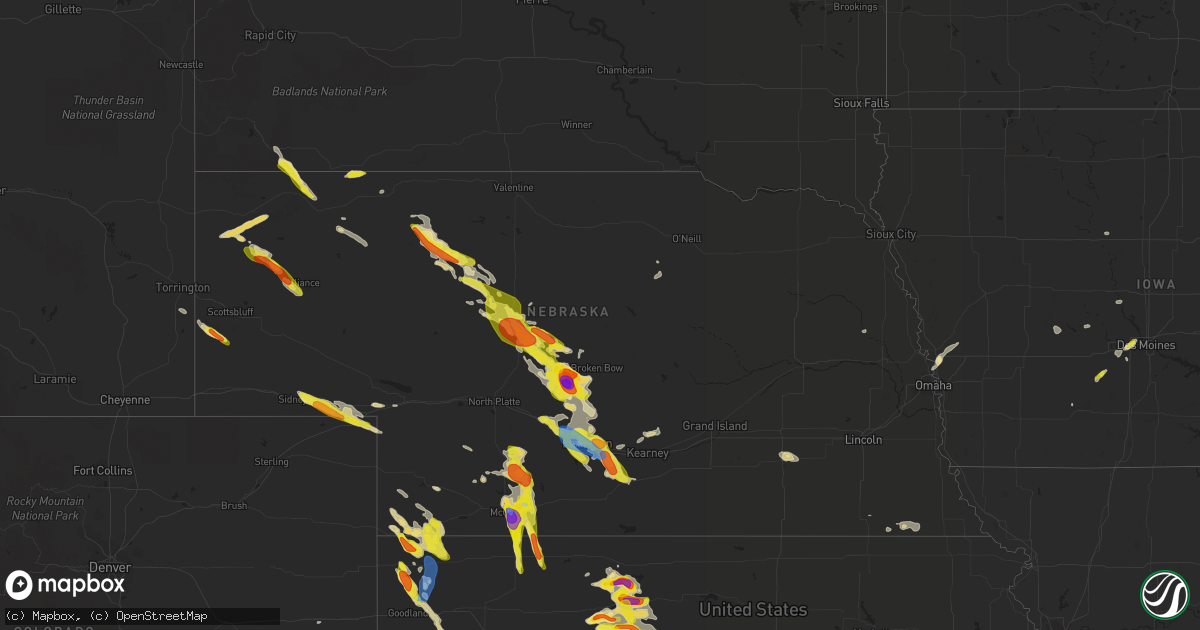
Hail Map in Nebraska on June 5, 2022
Get this storm
June 5 map
$229
one time, instant access
Download today. No call, no setup
Keep the $229
Bought the map and want the full workflow? Apply the entire $229 to a subscription within 7 days. None of it is wasted.
Every map, not just this one
This buys you this map. Subscription and you get every map we run, in the markets you choose from a few cities to whole states to nationwide. Plus real-time alerts the moment a storm fires.
Contact data
Name, contact info, occupancy, even credit band for addresses in the footprint. You go from where it hit to who to call.
Become the source they trust
Unlimited branding weather history reports on demand. You already have the documented answer ready for the property owner, and you are the one who showed up with it.
Property data and RoofTrace estimates
Pull up any address you have got, its value and the exact code rules for that jurisdiction, straight from One Click Code. Then RoofTrace estimates the squares, pitch, and roof value, priced the way you price.
Storm reports in Nebraska
Nebraska
| Date | Description |
|---|---|
| 06/05/20226:58 PM CDT | A local report indicates 1.00 inch wind near 12 ENE STAPLETON |
| 06/05/20226:50 PM CDT | Started as pea size and reached quarter size hail |
| 06/05/20226:40 PM CDT | Report via social media about 20 minutes after hail fell. |
| 06/05/20226:35 PM CDT | A local report indicates 1.00 inch wind near 16 N STAPLETON |
| 06/05/20226:29 PM CDT | A local report indicates 1.75 inch wind near 4 NW CALLAWAY |
| 06/05/20226:28 PM CDT | Homes in callaway sustained hail damage to windows on the north and northeast sides of homes. Largest hail stones the size of baseballs. The hail fell for 15 minutes. |
| 06/05/20226:28 PM CDT | Hail to half dollar size fell for 15 minutes that broke numerous windshields and windows of homes in callaway. Siding on homes sustained damage as well. |
| 06/05/20226:13 PM CDT | Quarter to half dollar size hail covering the ground. |
| 06/05/20225:11 PM CDT | Tents destroyed at art fair. |
| 06/05/20225:03 PM CDT | Landspout touched down in open field for a minute then lifted. No damage reported. |
| 06/05/20224:50 PM CDT | Quarter to half dollar size hail covering most of the ground. |
| 06/05/20224:26 PM CDT | Large hail falling most the size of quarters.hail forlast 10 minutes. |
| 06/05/20226:56 AM CDT | At 1156 PM CDT, a severe thunderstorm was located 4 miles southwest of Lebanon, or 15 miles northeast of Oberlin, moving south at 20 mph. HAZARD...Ping pong ball size hail. SOURCE...Radar indicated. IMPACT...People and animals outdoors will be injured. Expect damage to roofs, siding, windows, and vehicles. Locations impacted include... Norcatur, Clayton, Jennings and Lenora. |
| 06/05/20226:32 AM CDT | At 1131 PM MDT, a severe thunderstorm was located 5 miles southwest of Chappell, moving southeast at 40 mph. HAZARD...Golf ball size hail and 60 mph wind gusts. SOURCE...Radar indicated. IMPACT...Expect damage to roofs, siding, and trees. People and animals outdoors will be injured. Expect hail damage to roofs, siding, windows, and vehicles. This severe thunderstorm will be near... Ovid around 1145 PM MDT.Other locations in the path of this severe thunderstorm includeJulesburg. |
| 06/05/20224:22 AM CDT | At 922 PM MDT, a severe thunderstorm was located 7 miles west of Wildcat Hills Campground, or 15 miles southwest of Scottsbluff, moving southeast at 30 mph. HAZARD...Ping pong ball size hail and 60 mph wind gusts. SOURCE...Radar indicated. IMPACT...People and animals outdoors will be injured. Expect hail damage to roofs, siding, windows, and vehicles. Expect wind damage to roofs, siding, and trees. Locations impacted include... Harrisburg. |
| 06/05/20224:03 AM CDT | At 903 PM CDT, a severe thunderstorm was located 7 miles north of Holdrege, moving southeast at 20 mph. HAZARD...60 mph wind gusts and quarter size hail. SOURCE...Radar indicated. IMPACT...Hail damage to vehicles is expected. Expect wind damage to roofs, siding, and trees. This severe thunderstorm will be near... Holdrege around 920 PM CDT.Other locations in the path of this severe thunderstorm include Funk,Axtell, Wilcox and Ragan. |
| 06/05/20223:30 AM CDT | At 830 PM CDT, a severe thunderstorm was located 4 miles northwest of Danbury, or 12 miles southeast of McCook, moving southeast at 25 mph. HAZARD...Ping pong ball size hail and 60 mph wind gusts. SOURCE...Radar indicated. IMPACT...People and animals outdoors will be injured. Expect hail damage to roofs, siding, windows, and vehicles. Expect wind damage to roofs, siding, and trees. This severe thunderstorm will be near... Danbury around 840 PM CDT. Lebanon around 850 PM CDT.Other locations in the path of this severe thunderstorm includeNorcatur. |
| 06/05/20223:23 AM CDT | At 822 PM CDT, a severe thunderstorm was located near Overton, or 8 miles east of Lexington, moving southeast at 20 mph. HAZARD...Golf ball size hail and 60 mph wind gusts. SOURCE...Trained weather spotters. IMPACT...People and animals outdoors will be injured. Expect hail damage to roofs, siding, windows, and vehicles. Expect wind damage to roofs, siding, and trees. This severe thunderstorm will be near... Overton around 830 PM CDT.Other locations in the path of this severe thunderstorm include ElmCreek and Odessa.This includes Interstate 80 between mile markers 231 and 266. |
| 06/05/20222:55 AM CDT | 8x10ft tin shed blew across the yard... With wind damage reported. Pea size hail was observed with up to 6 inch drifts. Corrected date. |
| 06/05/20222:44 AM CDT | At 744 PM CDT, severe thunderstorms were located along a line extending from near Eddyville to near Lexington, moving southeast at 20 mph. HAZARD...60 mph wind gusts and quarter size hail. SOURCE...Trained weather spotters. IMPACT...Hail damage to vehicles is expected. Expect wind damage to roofs, siding, and trees. Severe thunderstorms will be near... Lexington around 755 PM CDT. Sumner around 800 PM CDT.Other locations in the path of these severe thunderstorms includeMiller, Overton and Amherst.This includes Interstate 80 between mile markers 211 and 254. |
| 06/05/20222:25 AM CDT | At 724 PM CDT, severe thunderstorms were located along a line extending from 3 miles southeast of Stockville to 10 miles northeast of Culbertson, moving southeast at 35 mph. HAZARD...60 mph wind gusts and half dollar size hail. SOURCE...Radar indicated. IMPACT...Hail damage to vehicles is expected. Expect wind damage to roofs, siding, and trees. Locations impacted include... McCook and Indianola. |
| 06/05/20222:10 AM CDT | Window and fence damage. Corrected date |
| 06/05/20222:07 AM CDT | At 707 PM CDT, severe thunderstorms were located along a line extending from Oconto to near Cozad to near Stockville, moving east at 30 mph. HAZARD...Quarter size hail. SOURCE...Radar indicated. IMPACT...Damage to vehicles is expected. Severe thunderstorms will be near... Cozad around 710 PM CDT.Other locations in the path of these severe thunderstorms includeLexington.This includes Interstate 80 between mile markers 209 and 239. |
| 06/05/20222:03 AM CDT | Estimated under golfball size hail with mostly quarter size and 3 to 4 ft drifts reported. 60 mph winds observed. Wheat crops destroyed and windows were broken. Correct |
| 06/05/20221:58 AM CDT | At 658 PM CDT, a severe thunderstorm was located 8 miles northeast of Gandy, or 11 miles east of Stapleton, moving southeast at 40 mph. HAZARD...Ping pong ball size hail and 60 mph wind gusts. SOURCE...Radar indicated. IMPACT...People and animals outdoors will be injured. Expect hail damage to roofs, siding, windows, and vehicles. Expect wind damage to roofs, siding, and trees. Locations impacted include... Broken Bow, Stapleton, Arnold, Callaway, Gandy, Logan, Shanklin Bluff, Tarboz Lake, Pleasant Hill, Hoagland, Milldale and Finchville.This includes the following highways... Highway 2 between mile markers 272 and 277. Highway 92 between mile markers 236 and 270. Highway 83 near mile marker 112. |
| 06/05/20221:45 AM CDT | At 644 PM CDT, a severe thunderstorm was located near Callaway, or 16 miles southwest of Broken Bow, moving southeast at 25 mph. HAZARD...Golf ball size hail and 60 mph wind gusts. SOURCE...Radar indicated. IMPACT...People and animals outdoors will be injured. Expect hail damage to roofs, siding, windows, and vehicles. Expect wind damage to roofs, siding, and trees. Locations impacted include... Callaway, Oconto, Buckeye, Block Hill Basin, Pressey State Wildlife Management Area, Milldale, Burr Oak, Finchville, Lodi, Intersection of Highway 183 and Cumro Road and Cumro.This includes Highway 183 between mile markers 73 and 84. |
| 06/05/20221:42 AM CDT | At 642 PM CDT, severe thunderstorms were located along a line extending from 9 miles northeast of Moorefield to near Curtis, moving southeast at 25 mph. HAZARD...Ping pong ball size hail and 60 mph wind gusts. SOURCE...Radar indicated. IMPACT...People and animals outdoors will be injured. Expect hail damage to roofs, siding, windows, and vehicles. Expect wind damage to roofs, siding, and trees. Locations impacted include... Curtis, Eustis, Moorefield, Stockville, Medicine Creek Reservoir State Recreation Area, Maywood, Hansen Memorial Reserve State Wildlife Management Area, Orafino, Freedom and Dancing Leaf Earth Lodge.This includes Highway 83 between mile markers 37 and 53. |
| 06/05/20221:13 AM CDT | At 612 PM CDT, a severe thunderstorm was located 14 miles south of Thedford, moving southeast at 45 mph. HAZARD...60 mph wind gusts and quarter size hail. SOURCE...Radar indicated. IMPACT...Hail damage to vehicles is expected. Expect wind damage to roofs, siding, and trees. Locations impacted include... Stapleton, Gandy, Logan, Highway 83 crossing The Dismal River, Shanklin Bluff, Tarboz Lake, Hoagland and Brown Lake.This includes the following highways... Highway 92 between mile markers 226 and 228, and between milemarkers 235 and 239. Highway 83 between mile markers 110 and 143. |
| 06/05/20221:04 AM CDT | At 604 PM CDT, a severe thunderstorm was located 10 miles northeast of Arnold, or 22 miles east of Stapleton, moving southeast at 30 mph. HAZARD...Ping pong ball size hail and 60 mph wind gusts. SOURCE...Radar indicated. IMPACT...People and animals outdoors will be injured. Expect hail damage to roofs, siding, windows, and vehicles. Expect wind damage to roofs, siding, and trees. Locations impacted include... Arnold and Pleasant Hill. This includes Highway 92 between mile markers 247 and 270. |
| 06/05/202212:46 AM CDT | At 546 PM CDT, a severe thunderstorm was located over Callaway, or 15 miles southwest of Broken Bow, moving southeast at 20 mph. HAZARD...Golf ball size hail and 60 mph wind gusts. SOURCE...Radar indicated. IMPACT...People and animals outdoors will be injured. Expect hail damage to roofs, siding, windows, and vehicles. Expect wind damage to roofs, siding, and trees. Locations impacted include... Callaway, Oconto, Buckeye, Pressey State Wildlife Management Area, Milldale, Finchville and Lodi. |
| 06/05/202212:33 AM CDT | At 532 PM CDT, a severe thunderstorm was located 11 miles southwest of Dunning, or 20 miles northeast of Stapleton, moving east at 20 mph. HAZARD...Ping pong ball size hail and 60 mph wind gusts. SOURCE...Radar indicated. IMPACT...People and animals outdoors will be injured. Expect hail damage to roofs, siding, windows, and vehicles. Expect wind damage to roofs, siding, and trees. Locations impacted include... Linscott.This includes Highway 2 between mile markers 241 and 255. |
| 06/05/202212:29 AM CDT | At 528 PM CDT/428 PM MDT/, severe thunderstorms were located along a line extending from 9 miles southwest of Brownlee to near Mullen, moving southeast at 30 mph. HAZARD...60 mph wind gusts and quarter size hail. SOURCE...Radar indicated. IMPACT...Hail damage to vehicles is expected. Expect wind damage to roofs, siding, and trees. Locations impacted include... Mullen, Thedford, Seneca, Norway, Highway 97 crossing the Dismal River, Giant Hill, Natwick, Kelso and Shimmons Lake.This includes the following highways... Highway 2 between mile markers 178 and 217. Highway 97 between mile markers 45 and 50, and between mile markers52 and 77. Highway 83 between mile markers 142 and 162. |
| 06/05/202212:25 AM CDT | Social media report |
| 06/05/202212:03 AM CDT | At 503 PM CDT, a severe thunderstorm was located 7 miles north of Callaway, or 15 miles west of Broken Bow, moving northeast at 15 mph. HAZARD...60 mph wind gusts and half dollar size hail. SOURCE...Radar indicated. IMPACT...Hail damage to vehicles is expected. Expect wind damage to roofs, siding, and trees. Locations impacted include... Merna and Milldale. This includes the following highways... Highway 2 between mile markers 266 and 273. Highway 92 between mile markers 267 and 273. |
| 06/04/202211:50 PM CDT | At 450 PM CDT/350 PM MDT/, a severe thunderstorm was located 16 miles northwest of Mullen, moving southeast at 30 mph. HAZARD...Golf ball size hail and 60 mph wind gusts. SOURCE...Radar indicated. IMPACT...People and animals outdoors will be injured. Expect hail damage to roofs, siding, windows, and vehicles. Expect wind damage to roofs, siding, and trees. Locations impacted include... Mullen, Giant Hill, Marsh Flat, Highway 97 crossing Big Creek, Sevenmile Hill and Kelso.This includes the following highways... Highway 2 between mile markers 180 and 191. Highway 97 between mile markers 62 and 88. |
| 06/04/202210:39 PM CDT | Harrisburg... Ne awos reports gust of 54 knots at site k1cw |
| 06/04/202210:04 PM CDT | At 304 PM MDT, a severe thunderstorm was located 16 miles south of Medicine Lake, or 38 miles northwest of Mullen, moving southeast at 20 mph. HAZARD...Ping pong ball size hail and 60 mph wind gusts. SOURCE...Radar indicated. IMPACT...People and animals outdoors will be injured. Expect hail damage to roofs, siding, windows, and vehicles. Expect wind damage to roofs, siding, and trees. Locations impacted include... Sevenmile Hill, Round Lake and Speckel Meir Lake. |
| 06/04/20228:30 PM CDT | Golf ball sized hail reported at location via social media. |
| 06/04/20228:26 PM CDT | Corrects previous hail report from 4 s mccook. Few hailstone reported at location via social media that were about 2/3rds the size of a dollar bill in diameter |
| 06/04/20228:26 PM CDT | Few hailstone reported at location via social media that were about half the size of a dollar bill in diameter |
| 06/04/20228:18 PM CDT | Estimated 50-60 mph gusts with heavy rainfall. |
| 06/04/20228:15 PM CDT | A local report indicates 68 MPH wind near 3 E LEXINGTON |
| 06/04/20228:10 PM CDT | 1 inch hail reported at location via social media. |
| 06/04/20228:05 PM CDT | Site moorenoi. |
| 06/04/20228:04 PM CDT | Estimated 2 inch hail reported at location via social media. |
| 06/04/20228:03 PM CDT | A local report indicates 64 MPH wind near 3 WNW LEXINGTON |
| 06/04/20228:01 PM CDT | A local report indicates 1.00 inch wind near 1 N LEXINGTON |
| 06/04/20228:00 PM CDT | Facebook photo. |
| 06/04/20227:57 PM CDT | Asos station kmck mccook airport. |
| 06/04/20227:35 PM CDT | A local report indicates 1.00 inch wind near 7 NW LEXINGTON |
| 06/04/20227:27 PM CDT | A local report indicates 1.25 inch wind near 8 SW CALLAWAY |
| 06/04/20227:13 PM CDT | Via spotternetwork.org |
All States Impacted by Hail Map on June 5, 2022
Cities Impacted by Hail Map on June 5, 2022
- Paul, ID
- Rupert, ID
- Burley, ID
- Heyburn, ID
- Bingham, NE
- Rushville, NE
- Guthrie Center, IA
- Newton, KS
- Arlington, KS
- Abbyville, KS
- Evergreen, AL
- Hunter, OK
- Bird City, KS
- Lamont, OK
- Edson, KS
- Oklahoma City, OK
- Lucas, KS
- Ashdown, AR
- Chadron, NE
- Hay Springs, NE
- Oelrichs, SD
- Perry, OK
- Gordon, NE
- Uniontown, WA
- Colton, WA
- Boise, ID
- Payette, ID
- Vale, OR
- Ontario, OR
- Wichita, KS
- Marsland, NE
- Wellington, KS
- Valley Center, KS
- Atkinson, NE
- Amelia, NE
- Great Bend, KS
- Ellinwood, KS
- St John, KS
- Hudson, KS
- Hays, KS
- Halsey, NE
- Bridgeport, NE
- Alliance, NE
- Haworth, OK
- Mountain Home, ID
- Hayes Center, NE
- Burlington, CO
- Arapahoe, CO
- Elgin, OR
- Big Springs, NE
- Waterville, WA
- Winterset, IA
- Elm Creek, NE
- Flagler, CO
- Thedford, NE
- Checotah, OK
- Benton, LA
- Bruneau, ID
- Hammett, ID
- King Hill, ID
- Hagerman, ID
- Jerome, ID
- Wendell, ID
- Buhl, ID
- Batesland, SD
- Heppner, OR
- Lexington, OR
- Waukee, IA
- West Des Moines, IA
- Windsor Heights, IA
- Clive, IA
- Urbandale, IA
- Ranchester, WY
- Parkman, WY
- Dayton, WY
- Mullen, NE
- Blue Springs, NE
- Murphy, ID
- Adrian, OR
- Jordan Valley, OR
- Merriman, NE
- Ellis, KS
- Plainville, KS
- McDonald, KS
- Stratton, NE
- Saint Francis, KS
- Max, NE
- Haigler, NE
- Parks, NE
- Benkelman, NE
- Brule, NE
- Ogallala, NE
- Dawson, IA
- Linden, IA
- Yale, IA
- Anthony, KS
- Konawa, OK
- Plummer, ID
- Lewiston, ID
- Vona, CO
- Priest River, ID
- Haven, KS
- Hutchinson, KS
- Stafford, KS
- Detroit, TX
- Clarksville, TX
- Derby, KS
- Scribner, NE
- Deport, TX
- Talco, TX
- Bogata, TX
- Coleman, OK
- Caddo, OK
- Bristow, OK
- Paris, TX
- Atlanta, KS
- Latham, KS
- Boswell, OK
- Van Meter, IA
- Adel, IA
- Booneville, IA
- Pretty Prairie, KS
- Dickens, NE
- Declo, ID
- Lamar, CO
- Holly, CO
- Two Buttes, CO
- Cheyenne Wells, CO
- Walsh, CO
- Sheridan Lake, CO
- Eads, CO
- Granada, CO
- Kit Carson, CO
- Okanogan, WA
- Bridgeport, WA
- Lenora, KS
- Sawyer, KS
- Kechi, KS
- Yoder, WY
- Torrington, WY
- Kamiah, ID
- Weippe, ID
- Spencer, OK
- Arthur City, TX
- Blossom, TX
- Powderly, TX
- Ellsworth, KS
- Goodland, KS
- Brewster, KS
- Winona, KS
- Colby, KS
- Wauneta, NE
- Phillipsburg, KS
- Champion, NE
- Medford, OK
- Caldwell, KS
- Perkins, OK
- Argonia, KS
- Freeport, KS
- Milan, KS
- Delaware, OK
- Allen, SD
- Caldwell, ID
- Melba, ID
- Nampa, ID
- Kuna, ID
- Longton, KS
- Hope, AR
- Bradley, AR
- Opelousas, LA
- Crescent, OK
- Wilmore, KS
- Moscow, ID
- Genesee, ID
- Lincoln, KS
- Duncombe, IA
- Cumming, IA
- Hemingford, NE
- Walker, KS
- Victoria, KS
- Crawford, NE
- Harrison, NE
- Burchard, NE
- Pawnee City, NE
- Du Bois, NE
- Sylvan Grove, KS
- Riverdale, NE
- Kearney, NE
- Oakesdale, WA
- Thornton, WA
- Juliaetta, ID
- Fairmont, NE
- McCool Junction, NE
- Exeter, NE
- Lyman, NE
- Harrisburg, NE
- Liberty, NE
- Fort Scott, KS
- Redfield, KS
- Gibbon, NE
- Ravenna, NE
- Pleasanton, NE
- Anselmo, NE
- Merna, NE
- Sumner, TX
- Hugo, OK
- Aline, OK
- Okeene, OK
- Sun City, KS
- Dacoma, OK
- Protection, KS
- Alva, OK
- Haviland, KS
- Waynoka, OK
- Cleo Springs, OK
- Freedom, OK
- Fairview, OK
- Coldwater, KS
- Chester, OK
- Medicine Lodge, KS
- Mooreland, OK
- Mullinville, KS
- Hardtner, KS
- Isabella, OK
- Carmen, OK
- Lake City, KS
- Maxwell, NE
- Bartley, NE
- Norcatur, KS
- Wellfleet, NE
- Moorefield, NE
- Indianola, NE
- Maywood, NE
- Danbury, NE
- Stockville, NE
- McCook, NE
- Curtis, NE
- Oberlin, KS
- Garden Plain, KS
- Humboldt, KS
- Georgiana, AL
- Forest Home, AL
- Chanute, KS
- Buffalo, KS
- Yates Center, KS
- Benedict, KS
- De Kalb, TX
- Lahoma, OK
- Meno, OK
- Enid, OK
- Carrier, OK
- Kremlin, OK
- Ringwood, OK
- Goltry, OK
- Helena, OK
- Valentine, NE
- Hughes Springs, TX
- Naples, TX
- Wapanucka, OK
- Oconto, NE
- Callaway, NE
- Sedgwick, KS
- Laurel Hill, FL
- Florala, AL
- Lake Creek, TX
- Cooper, TX
- Opp, AL
- Malta, ID
- Plaquemine, LA
- Winter Haven, FL
- Overton, NE
- Loomis, NE
- Bertrand, NE
- Baxley, GA
- Surrency, GA
- Cody, NE
- Whitman, NE
- Palco, KS
- Damar, KS
- Bogue, KS
- Stockton, KS
- Cozad, NE
- Chappell, NE
- Sidney, NE
- Lodgepole, NE
- Mount Hope, KS
- Burrton, KS
- Saint Martinville, LA
- Halstead, KS
- McDavid, FL
- Bentley, KS
- Colwich, KS
- Maize, KS
- Plain Dealing, LA
- Coats, KS
- Yukon, OK
- Edmond, OK
- Jones, OK
- Arcadia, OK
- Guthrie, OK
- Piedmont, OK
- Waukomis, OK
- Maramec, OK
- Jennings, OK
- Foreman, AR
- Spiro, OK
- Dike, TX
- Sulphur Springs, TX
- Westwego, LA
- New Orleans, LA
- Kenner, LA
- Saint Rose, LA
- Metairie, LA
- Ama, LA
- Carrabelle, FL
- Eddyville, NE
- Arnold, NE
- Stapleton, NE
- Broken Bow, NE
- Gothenburg, NE
- Shreveport, LA
- Bossier City, LA
- Barksdale Afb, LA
- Arkansas City, KS
- Newkirk, OK
- Stratford, OK
- Enterprise, AL
- Coalgate, OK
- Douglas, OK
- Eufaula, OK
- Lenapah, OK
- Geuda Springs, KS
- Pond Creek, OK
- Holt, FL
- Marshall, OK
- Stillwater, OK
- Orlando, OK
- Mulhall, OK
- Cashion, OK
- Bagwell, TX
- Carencro, LA
- Ariton, AL
- Burlington, OK
- Natoma, KS
- Prattville, AL
- Vernon, FL
- Glade, KS
- Clearwater, KS
- Haysville, KS
- Dorrance, KS
- Wilson, KS
- Luray, KS
- Paradise, KS
- Russell, KS
- Waldo, KS
- Bunker Hill, KS
- Stonewall, OK
- Milburn, OK
- Kirwin, KS
- Logan, KS
- Braman, OK
- Wellston, OK
- Kingman, KS
- Wakita, OK
- Kaw City, OK
- Shidler, OK
- Coyle, OK
- Missouri Valley, IA
- Honey Creek, IA
- Gorham, KS
- Catharine, KS
- Eustis, NE
- Smithfield, NE
- Elwood, NE
- Willow Island, NE
- Seneca, NE
- Holdrege, NE
- Funk, NE
- Lexington, NE
- Fort Towson, OK
- Eclectic, AL
- Moundridge, KS
- Buhler, KS
- Inman, KS
- Windom, KS
- Little River, KS
- Mcpherson, KS
- Bokchito, OK
- Bennington, OK
- Nash, OK
- Manchester, OK
- Lewisville, AR
- Breaux Bridge, LA
- Creston, IA
- Hoisington, KS
- Prairie View, KS
- Woodston, KS
- Claflin, KS
- Holyrood, KS
- Alton, KS
- Tonkawa, OK
- Douglassville, TX
- Stigler, OK
- Bison, OK
- Julesburg, CO
- Ovid, CO
- Sedgwick, CO
- Elk Falls, KS
- Billings, OK
- Garber, OK
- Ada, OK
- Wanette, OK
- Tupelo, OK
- Centrahoma, OK
- Tecumseh, OK
- Fitzhugh, OK
- Noble, OK
- Norman, OK
- Shawnee, OK
- Fittstown, OK
- Lexington, OK
- Byars, OK
- Roff, OK
- Newalla, OK
- Mcloud, OK
- Atoka, OK
- Macomb, OK
- Asher, OK
- Allen, OK
- Nowata, OK
- Wetumpka, AL
- Kiowa, KS
- Hazelton, KS
- Goddard, KS
- Viola, KS
- Terlton, OK
- Cleveland, OK
- Pattonville, TX
- Waldron, AR
- Hennessey, OK
- Dover, OK
- Andale, KS
- Nickerson, KS
- Lafayette, LA
- Broussard, LA
- Blackwell, OK
- Lorraine, KS
- Geneseo, KS
- Castleberry, AL
- Ames, OK
- Bluff City, KS
- Robertsdale, AL
- Seminole, AL
- Ashton, ID
- Fort Calhoun, NE
- Crescent, IA
- Persia, IA
- Logan, IA
- Omaha, NE
- Norco, LA
- Hahnville, LA
- Destrehan, LA
- Dozier, AL
- Gantt, AL
- Boone, IA
- Madrid, IA
- Woodward, IA
- Lyons, KS
- Mannford, OK
- Sparks, OK
- Chandler, OK
- Stroud, OK
- Edgard, LA
- Reserve, LA
- Mount Airy, LA
- Garyville, LA
- Thibodaux, LA
- Meridian, OK
- Luther, OK
- Lowndesboro, AL
- Montgomery, AL
- Okemah, OK
- Boley, OK
- Castle, OK
- Fulton, AR
- Ogden, AR
- Harper, KS
- Wilder, ID
- Homedale, ID
- Glenns Ferry, ID
- Garden City, ID
- Eagle, ID
- Star, ID
- Venango, NE
- Meridian, ID
- Tensed, ID
- Farmington, WA
- Culdesac, ID
- Lapwai, ID
- Red Rock, OK
- Glencoe, OK
- Morrison, OK
- Skiatook, OK
- Osage, OK
- Owasso, OK
- Tulsa, OK
- Hominy, OK
- Pawnee, OK
- Ralston, OK
- Ponca City, OK
- Fairfax, OK
- Sperry, OK
- Prue, OK
- Sand Springs, OK
- Marland, OK
- Collinsville, OK
- Barnsdall, OK
- Wynona, OK
- Drummond, OK
- Stratton, CO
- Tryon, NE
- Lebanon, NE
- Jennings, KS
- Clarkston, WA
- East Wenatchee, WA


