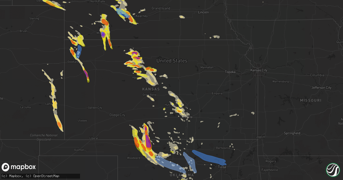
Hail Map in Kansas on June 5, 2022
Get this storm
June 5 map
$229
one time, instant access
Download today. No call, no setup
Keep the $229
Bought the map and want the full workflow? Apply the entire $229 to a subscription within 7 days. None of it is wasted.
Every map, not just this one
This buys you this map. Subscription and you get every map we run, in the markets you choose from a few cities to whole states to nationwide. Plus real-time alerts the moment a storm fires.
Contact data
Name, contact info, occupancy, even credit band for addresses in the footprint. You go from where it hit to who to call.
Become the source they trust
Unlimited branding weather history reports on demand. You already have the documented answer ready for the property owner, and you are the one who showed up with it.
Property data and RoofTrace estimates
Pull up any address you have got, its value and the exact code rules for that jurisdiction, straight from One Click Code. Then RoofTrace estimates the squares, pitch, and roof value, priced the way you price.
Storm reports in Kansas
Kansas
| Date | Description |
|---|---|
| 06/05/20226:20 PM CDT | Public report via kake tv. |
| 06/05/20225:56 PM CDT | Quarter to half dollar size hail ongoing. |
| 06/05/20225:51 PM CDT | Sporadic quarter sized stones. Mostly dime to nickel sized. |
| 06/05/20225:34 PM CDT | A local report indicates 1.00 inch wind near PLAINVILLE |
| 06/05/20225:28 PM CDT | Golf ball sized hail reported at location. |
| 06/05/20225:26 PM CDT | A large amount of quarter to ping pong ball sized hail. |
| 06/05/20225:24 PM CDT | A local report indicates 1.00 inch wind near ZURICH |
| 06/05/20223:27 PM CDT | Quarter to golf ball size. |
| 06/05/20222:29 PM CDT | A local report indicates 1.75 inch wind near 7 S GLADE |
| 06/05/20222:02 PM CDT | Facebook picture... Time estimated from radar. |
| 06/05/20227:52 AM CDT | At 1251 AM CDT, severe thunderstorms were located along a line extending from near Olmitz to near Pawnee Rock to 7 miles northeast of Rozel, moving southeast at 40 mph. HAZARD...Two inch hail and 60 mph wind gusts. SOURCE...Radar indicated. IMPACT...People and animals outdoors will be injured. Expect hail damage to roofs, siding, windows, and vehicles. Expect wind damage to roofs, siding, and trees. Severe thunderstorms will be near... Radium and Frizell around 110 AM CDT.Other locations in the path of these severe thunderstorms includeLarned, Seward, St. John, Macksville and Hudson. |
| 06/05/20227:36 AM CDT | At 1236 AM CDT, severe thunderstorms were located along a line extending from near Gorham to Otis to 6 miles south of Nekoma, moving southeast at 35 mph. HAZARD...70 mph wind gusts and quarter size hail. SOURCE...Radar indicated. IMPACT...Hail damage to vehicles is expected. Expect considerable tree damage. Wind damage is also likely to mobile homes, roofs, and outbuildings. Locations impacted include... Great Bend, Russell, Lyons, Ellsworth, Hoisington, Ellinwood, Wilson, Claflin, Kanopolis, Chase, Holyrood, Gorham, Bushton, Geneseo, Pawnee Rock, Dorrance, Albert, Alden, Lorraine and Olmitz.This includes Interstate 70 between Mile Markers 176 and 200. |
| 06/05/20227:31 AM CDT | At 1231 AM CDT, a severe thunderstorm was located near Lucas, or 13 miles north of Wilson, moving east at 30 mph. HAZARD...60 mph wind gusts and nickel size hail. SOURCE...Radar indicated. IMPACT...Expect damage to roofs, siding, and trees. Locations impacted include... Ellsworth, Wilson, Lincoln, Lucas, Sylvan Grove, Luray, Dorrance, Barnard, Bunker Hill, Ash Grove, Ellsworth Airport, Wilson State Park and Wilson Lake.This includes Interstate 70 between Mile Markers 198 and 229. |
| 06/05/20226:46 AM CDT | At 1146 PM CDT, a severe thunderstorm was located 11 miles north of Freedom, moving southeast at 15 mph. HAZARD...Ping pong ball size hail and 60 mph wind gusts. SOURCE...Radar indicated. IMPACT...People and animals outdoors will be injured. Expect hail damage to roofs, siding, windows, and vehicles. Expect wind damage to roofs, siding, and trees. Locations impacted include... Freedom and Camp Houston. |
| 06/05/20226:10 AM CDT | At 1109 PM CDT, a severe thunderstorm was located near Stockton, or 19 miles south of Phillipsburg, moving southeast at 30 mph. HAZARD...Quarter size hail. SOURCE...Radar indicated. IMPACT...Damage to vehicles is expected. This severe thunderstorm will be near... Stockton around 1115 PM CDT.Other locations in the path of this severe thunderstorm includeWoodston and Natoma. |
| 06/05/20225:56 AM CDT | At 1056 PM CDT, severe thunderstorms were located along a line extending from Newton to near Bentley to 6 miles west of Andale, moving southeast at 35 mph. HAZARD...60 mph wind gusts and quarter size hail. SOURCE...Radar indicated. IMPACT...Hail damage to vehicles is expected. Expect wind damage to roofs, siding, and trees. Locations impacted include... Wichita, Derby, Newton, Andover, Haysville, Augusta, Park City, Valley Center, Bel Aire, Mulvane, Goddard, Rose Hill, Maize, Clearwater, Sedgwick, Colwich, Benton, Garden Plain, Mount Hope and Downtown Wichita.This includes the following highways... Interstate 135 between Mile Markers 0 and 30. Interstate 35 between Mile Markers 34 and 64. |
| 06/05/20225:48 AM CDT | At 1048 PM CDT, a severe thunderstorm was located 4 miles northwest of Bartley, or 15 miles northeast of McCook, moving southeast at 15 mph. HAZARD...Ping pong ball size hail. SOURCE...Radar indicated. IMPACT...People and animals outdoors will be injured. Expect damage to roofs, siding, windows, and vehicles. This severe thunderstorm will be near... Indianola around 1100 PM CDT.Other locations in the path of this severe thunderstorm includeBartley and Lebanon. |
| 06/05/20225:18 AM CDT | At 1018 PM CDT, a severe thunderstorm was located over Hutchinson, moving east at 30 mph. HAZARD...60 mph wind gusts and quarter size hail. SOURCE...Radar indicated. IMPACT...Hail damage to vehicles is expected. Expect wind damage to roofs, siding, and trees. Locations impacted include... Hutchinson, South Hutchinson, Buhler, Haven, Burrton, Yoder and Hutchinson Airport. |
| 06/05/20225:17 AM CDT | At 1016 PM CDT, a severe thunderstorm was located near Moundridge, moving east at 30 mph. HAZARD...60 mph wind gusts and quarter size hail. SOURCE...Radar indicated. IMPACT...Hail damage to vehicles is expected. Expect wind damage to roofs, siding, and trees. Locations impacted include... Newton, Hesston, Halstead, North Newton, Moundridge, Sedgwick, Goessel, Walton and Newton Airport.This includes Interstate 135 between Mile Markers 26 and 55. |
| 06/05/20225:04 AM CDT | At 1004 PM CDT, a severe thunderstorm was located near Aetna, moving south at 25 mph. HAZARD...Tennis ball size hail and 70 mph wind gusts. SOURCE...Radar indicated. IMPACT...People and animals outdoors will be injured. Expect hail damage to roofs, siding, windows, and vehicles. Expect considerable tree damage. Wind damage is also likely to mobile homes, roofs, and outbuildings. Locations impacted include... Alva, Cherokee, Ingersoll and Capron. |
| 06/05/20224:59 AM CDT | At 959 PM CDT, a severe thunderstorm was located 8 miles north of Aetna, moving southeast at 25 mph. HAZARD...Golf ball size hail. SOURCE...Radar indicated. IMPACT...People and animals outdoors will be injured. Expect damage to roofs, siding, windows, and vehicles. This severe thunderstorm will be near... Aetna around 1015 PM CDT.Other locations in the path of this severe thunderstorm includeHardtner. |
| 06/05/20224:45 AM CDT | At 945 PM CDT, a severe thunderstorm was located near Winona, or 19 miles south of Brewster, moving south at 40 mph. HAZARD...60 mph wind gusts and half dollar size hail. SOURCE...Radar indicated. IMPACT...Hail damage to vehicles is expected. Expect wind damage to roofs, siding, and trees. This severe thunderstorm will be near... Russell Springs around 1005 PM CDT. |
| 06/05/20224:14 AM CDT | At 914 PM CDT, a severe thunderstorm was located over Oberlin, moving south at 20 mph. HAZARD...70 mph wind gusts and quarter size hail. SOURCE...Radar indicated. IMPACT...Hail damage to vehicles is expected. Expect considerable tree damage. Wind damage is also likely to mobile homes, roofs, and outbuildings. Locations impacted include... Dresden. |
| 06/05/20224:12 AM CDT | At 912 PM CDT, a severe thunderstorm was located near Sun City, moving south at 15 mph. HAZARD...Half dollar size hail. SOURCE...Radar indicated. IMPACT...Damage to vehicles is expected. This severe thunderstorm will be near... Sun City around 920 PM CDT.Other locations in the path of this severe thunderstorm include LakeCity. |
| 06/05/20222:36 AM CDT | At 735 PM CDT, a severe thunderstorm was located 9 miles east of Milberger, or 10 miles southeast of Russell, moving east at 25 mph. HAZARD...60 mph wind gusts and quarter size hail. SOURCE...Radar indicated. IMPACT...Hail damage to vehicles is expected. Expect wind damage to roofs, siding, and trees. Locations impacted include... Wilson, Holyrood, Dorrance, Bunker Hill, Susank, Wilson State Park and Wilson Lake.This includes Interstate 70 between Mile Markers 189 and 212. This warning replaces the previous severe thunderstorm warning for western Russell county. |
| 06/05/20222:16 AM CDT | At 716 PM MDT/816 PM CDT/, a severe thunderstorm was located 9 miles south of St. Francis, moving southeast at 55 mph. HAZARD...60 mph wind gusts and quarter size hail. SOURCE...Radar indicated. IMPACT...Hail damage to vehicles is expected. Expect wind damage to roofs, siding, and trees. This severe thunderstorm will be near... Goodland around 735 PM MDT.Other locations in the path of this severe thunderstorm includeBrewster.This includes Interstate 70 in Kansas between mile markers 13 and 53. |
| 06/05/20221:43 AM CDT | At 643 PM CDT, a severe thunderstorm was located near Gorham, or near Emmeram, moving east at 20 mph. HAZARD...60 mph wind gusts and half dollar size hail. SOURCE...Radar indicated. IMPACT...Hail damage to vehicles is expected. Expect wind damage to roofs, siding, and trees. Locations impacted include... Russell, Gorham, Bunker Hill and Russell Airport. This includes Interstate 70 between Mile Markers 175 and 195. |
| 06/05/20221:40 AM CDT | At 640 PM CDT, a severe thunderstorm was located over Lucas, or 18 miles north of Wilson, moving east at 20 mph. HAZARD...60 mph wind gusts and quarter size hail. SOURCE...Radar indicated. IMPACT...Hail damage to vehicles is expected. Expect wind damage to roofs, siding, and trees. Locations impacted include... Lucas, Sylvan Grove, Luray and Ash Grove. |
| 06/05/20221:30 AM CDT | At 630 PM CDT, a severe thunderstorm was located very near Emmeram, moving east at 15 mph. HAZARD...Ping pong ball size hail. SOURCE...Radar indicated. IMPACT...People and animals outdoors will be injured. Expect damage to roofs, siding, windows, and vehicles. This severe thunderstorm will be near... Walker around 645 PM CDT. |
| 06/05/20221:13 AM CDT | At 613 PM MDT/713 PM CDT/, severe thunderstorms were located along a line extending from 9 miles south of Stratton to 9 miles southeast of Haigler, moving south at 30 mph. HAZARD...70 mph wind gusts and half dollar size hail. SOURCE...Radar indicated. IMPACT...Hail damage to vehicles is expected. Expect considerable tree damage. Wind damage is also likely to mobile homes, roofs, and outbuildings. Locations impacted include... St. Francis and McDonald. |
| 06/05/202212:56 AM CDT | At 555 PM CDT, a cluster of severe thunderstorms were located along a line extending from near Palco to near Codell, moving east at 10 mph. HAZARD...Quarter size hail. SOURCE...Radar indicated. IMPACT...Damage to vehicles is expected. Severe thunderstorms will be near... Plainville around 600 PM CDT. Codell around 610 PM CDT.Other locations in the path of these severe thunderstorms includeNatoma. |
| 06/05/202212:53 AM CDT | At 553 PM CDT, a severe thunderstorm was located 8 miles north of Catherine, moving east at 20 mph. HAZARD...Quarter size hail. SOURCE...Radar indicated. IMPACT...Damage to vehicles is expected. This severe thunderstorm will be near... Emmeram around 610 PM CDT. |
| 06/05/202212:45 AM CDT | At 545 PM CDT, a severe thunderstorm was located over Codell, or 18 miles north of Emmeram, moving east at 15 mph. HAZARD...Quarter size hail. SOURCE...Radar indicated. IMPACT...Damage to vehicles is expected. This severe thunderstorm will be near... Natoma around 600 PM CDT. |
| 06/05/202212:44 AM CDT | At 544 PM CDT, a severe thunderstorm was located 9 miles southeast of Natoma, or 16 miles north of Russell, moving east at 15 mph. HAZARD...60 mph wind gusts and half dollar size hail. SOURCE...Radar indicated. IMPACT...Hail damage to vehicles is expected. Expect wind damage to roofs, siding, and trees. Locations impacted include... Luray, Paradise and Waldo. |
| 06/05/202212:43 AM CDT | At 543 PM CDT, a severe thunderstorm was located 8 miles southeast of Natoma, or 16 miles north of Russell, moving northeast at 15 mph. HAZARD...Quarter size hail. SOURCE...Radar indicated. IMPACT...Damage to vehicles is expected. This severe thunderstorm will remain over mainly rural areas of south central Osborne County. |
| 06/05/202212:40 AM CDT | At 540 PM MDT/640 PM CDT/, a severe thunderstorm was located 11 miles north of Benkelman, moving southeast at 25 mph. HAZARD...60 mph wind gusts and half dollar size hail. SOURCE...Radar indicated. IMPACT...Hail damage to vehicles is expected. Expect wind damage to roofs, siding, and trees. Locations impacted include... Benkelman. |
| 06/05/202212:33 AM CDT | At 533 PM MDT/633 PM CDT/, a severe thunderstorm was located 11 miles northeast of Haigler, or 17 miles northwest of Benkelman, moving southeast at 25 mph. HAZARD...60 mph wind gusts and half dollar size hail. SOURCE...Radar indicated. IMPACT...Hail damage to vehicles is expected. Expect wind damage to roofs, siding, and trees. This severe thunderstorm will remain over mainly rural areas of northeastern Cheyenne County in northwestern Kansas and western Dundy Counties in southwestern Nebraska, including the following locations... Parks. |
| 06/05/202212:28 AM CDT | At 528 PM CDT, a severe thunderstorm was located near Woodston, or 28 miles north of Emmeram, moving east at 10 mph. HAZARD...Quarter size hail. SOURCE...Radar indicated. IMPACT...Damage to vehicles is expected. This severe thunderstorm will remain over mainly rural areas of east central Rooks and west central Osborne Counties. |
| 06/05/202212:24 AM CDT | At 524 PM CDT, a severe thunderstorm was located over Damar, or 12 miles east of Hill City, moving northeast at 10 mph. HAZARD...Quarter size hail. SOURCE...Radar indicated. IMPACT...Damage to vehicles is expected. This severe thunderstorm will be near... Palco around 530 PM CDT. Damar around 535 PM CDT.Other locations in the path of this severe thunderstorm includeWebster State Park. |
| 06/05/202212:13 AM CDT | At 512 PM CDT, a severe thunderstorm was located over Zurich, or 22 miles northeast of Ellis, moving northeast at 5 mph. HAZARD...Quarter size hail. SOURCE...Radar indicated. IMPACT...Damage to vehicles is expected. This severe thunderstorm will be near... Plainville around 520 PM CDT. |
| 06/05/202212:09 AM CDT | At 509 PM CDT, a severe thunderstorm was located near Bogue, or 10 miles east of Hill City, moving northeast at 20 mph. HAZARD...Half dollar size hail. SOURCE...Radar indicated. IMPACT...Damage to vehicles is expected. This severe thunderstorm will be near... Nicodemus around 525 PM CDT. |
| 06/05/202212:04 AM CDT | Report from mping: half dollar |
| 06/04/202211:45 PM CDT | At 445 PM CDT, severe thunderstorms were located along a line extending from near Logan to 6 miles north of Webster State Park to near Stockton, and are nearly stationary. HAZARD...60 mph wind gusts and half dollar size hail. SOURCE...Radar indicated. IMPACT...Hail damage to vehicles is expected. Expect wind damage to roofs, siding, and trees. Locations impacted include... Stockton, Logan, Woodston and Speed. |
| 06/04/202211:37 PM CDT | A local report indicates 1.25 inch wind near COLDWATER |
| 06/04/202211:25 PM CDT | Report from mping: 3-inch tree limbs broken; power poles broken. |
| 06/04/202211:04 PM CDT | At 403 PM CDT, severe thunderstorms were located along a line extending from Logan to near Stockton to Woodston, moving east at 10 mph. HAZARD...60 mph wind gusts and quarter size hail. SOURCE...Radar indicated. IMPACT...Hail damage to vehicles is expected. Expect wind damage to roofs, siding, and trees. Severe thunderstorms will be near... Woodston around 410 PM CDT.Other locations in the path of these severe thunderstorms includeAlton and Speed. |
| 06/04/202211:00 PM CDT | A local report indicates 1.50 inch wind near MOUNT HOPE |
| 06/04/202210:49 PM CDT | Report from mping: 1-inch tree limbs broken; shingles blown off. |
| 06/04/202210:45 PM CDT | Report from mping: half dollar |
| 06/04/202210:30 PM CDT | At 329 PM MDT, a severe thunderstorm was located 11 miles southeast of Kit Carson, or 15 miles southwest of Cheyenne Wells, moving southeast at 20 mph. HAZARD...Ping pong ball size hail and 60 mph wind gusts. SOURCE...Radar indicated. IMPACT...People and animals outdoors will be injured. Expect hail damage to roofs, siding, windows, and vehicles. Expect wind damage to roofs, siding, and trees. Locations impacted include... Chivington, Brandon and Sheridan Lake. |
| 06/04/202210:25 PM CDT | At 324 PM CDT, a severe thunderstorm was located over Stockton, or 21 miles south of Phillipsburg, moving east at 15 mph. HAZARD...Two inch hail. SOURCE...Radar indicated. IMPACT...People and animals outdoors will be injured. Expect damage to roofs, siding, windows, and vehicles. Locations impacted include... Woodston. |
| 06/04/202210:03 PM CDT | Half dollar sized hail reported at location via social media. |
| 06/04/20229:51 PM CDT | At 251 AM CDT, severe thunderstorms were located along a line extending from near Abbyville to near Cunningham to 5 miles south of Cullison, moving southeast at 35 mph. HAZARD...60 mph wind gusts and penny size hail. SOURCE...Radar indicated. IMPACT...Expect damage to roofs, siding, and trees. Locations impacted include... Kingman, Pretty Prairie, Norwich, Arlington, Cunningham, Turon, Partridge, Sylvia, Plevna, Abbyville, Nashville, Murdock, Waterloo, Willowdale, Zenda, Spivey, Langdon, Cleveland, Penalosa and Mt Vernon. |
| 06/04/20229:43 PM CDT | At 242 PM CDT, severe thunderstorms were located along a line extending from near Phillipsburg to 8 miles southwest of Kirwin to near Webster State Park, moving east at 20 mph. HAZARD...Two inch hail and 60 mph wind gusts. SOURCE...Trained weather spotters. IMPACT...People and animals outdoors will be injured. Expect hail damage to roofs, siding, windows, and vehicles. Expect wind damage to roofs, siding, and trees. Severe thunderstorms will be near... Kirwin around 300 PM CDT.Other locations in the path of these severe thunderstorms includeAlton, Stockton, Woodston. |
| 06/04/20229:33 PM CDT | A local report indicates 1.75 inch wind near 1 ENE SUN CITY |
| 06/04/20229:27 PM CDT | A local report indicates 1.00 inch wind near SUN CITY |
| 06/04/20229:26 PM CDT | A local report indicates 1.75 inch wind near 1 S SUN CITY |
| 06/04/20229:00 PM CDT | At 200 PM CDT, a severe thunderstorm was located near Speed, or 10 miles southwest of Phillipsburg, moving east at 20 mph. HAZARD...Quarter size hail. SOURCE...Radar indicated. IMPACT...Damage to vehicles is expected. This severe thunderstorm will be near... Glade around 220 PM CDT.Other locations in the path of this severe thunderstorm includeKirwin. |
| 06/04/20228:27 PM CDT | Still ongoing 5 minutes later. Some may be slightly larger than golf ball size. |
| 06/04/20228:25 PM CDT | At 124 AM CDT, a severe thunderstorm was located near Kanopolis, moving east at 30 mph. HAZARD...60 mph wind gusts and quarter size hail. SOURCE...Radar indicated. IMPACT...Hail damage to vehicles is expected. Expect wind damage to roofs, siding, and trees. Locations impacted include... Salina, Lindsborg, Marquette, Brookville, Smolan, Falun, Kanopolis Lake, Salina Airport and Kanopolis State Park.This includes Interstate 135 between Mile Markers 91 and 92. |
| 06/04/20227:58 PM CDT | Possible brief land spout occurred for 45 seconds then ended on hwy 27 on leading edge of advancing storm. |
| 06/04/20227:50 PM CDT | Corrects previous hail report from saint francis. Report from mping: quarter |
| 06/04/20227:26 PM CDT | A local report indicates 62 MPH wind near 2 E RUSSELL AIRPORT |
| 06/04/20227:25 PM CDT | Accumulating hail up to golf ball size reported at location via social media. Hail did damage to an outdoor flower pot. |
| 06/04/20227:10 PM CDT | Report from mping: quarter |
All States Impacted by Hail Map on June 5, 2022
Cities Impacted by Hail Map on June 5, 2022
- Paul, ID
- Rupert, ID
- Burley, ID
- Heyburn, ID
- Bingham, NE
- Rushville, NE
- Guthrie Center, IA
- Newton, KS
- Arlington, KS
- Abbyville, KS
- Evergreen, AL
- Hunter, OK
- Bird City, KS
- Lamont, OK
- Edson, KS
- Oklahoma City, OK
- Lucas, KS
- Ashdown, AR
- Chadron, NE
- Hay Springs, NE
- Oelrichs, SD
- Perry, OK
- Gordon, NE
- Uniontown, WA
- Colton, WA
- Boise, ID
- Payette, ID
- Vale, OR
- Ontario, OR
- Wichita, KS
- Marsland, NE
- Wellington, KS
- Valley Center, KS
- Atkinson, NE
- Amelia, NE
- Great Bend, KS
- Ellinwood, KS
- St John, KS
- Hudson, KS
- Hays, KS
- Halsey, NE
- Bridgeport, NE
- Alliance, NE
- Haworth, OK
- Mountain Home, ID
- Hayes Center, NE
- Burlington, CO
- Arapahoe, CO
- Elgin, OR
- Big Springs, NE
- Waterville, WA
- Winterset, IA
- Elm Creek, NE
- Flagler, CO
- Thedford, NE
- Checotah, OK
- Benton, LA
- Bruneau, ID
- Hammett, ID
- King Hill, ID
- Hagerman, ID
- Jerome, ID
- Wendell, ID
- Buhl, ID
- Batesland, SD
- Heppner, OR
- Lexington, OR
- Waukee, IA
- West Des Moines, IA
- Windsor Heights, IA
- Clive, IA
- Urbandale, IA
- Ranchester, WY
- Parkman, WY
- Dayton, WY
- Mullen, NE
- Blue Springs, NE
- Murphy, ID
- Adrian, OR
- Jordan Valley, OR
- Merriman, NE
- Ellis, KS
- Plainville, KS
- McDonald, KS
- Stratton, NE
- Saint Francis, KS
- Max, NE
- Haigler, NE
- Parks, NE
- Benkelman, NE
- Brule, NE
- Ogallala, NE
- Dawson, IA
- Linden, IA
- Yale, IA
- Anthony, KS
- Konawa, OK
- Plummer, ID
- Lewiston, ID
- Vona, CO
- Priest River, ID
- Haven, KS
- Hutchinson, KS
- Stafford, KS
- Detroit, TX
- Clarksville, TX
- Derby, KS
- Scribner, NE
- Deport, TX
- Talco, TX
- Bogata, TX
- Coleman, OK
- Caddo, OK
- Bristow, OK
- Paris, TX
- Atlanta, KS
- Latham, KS
- Boswell, OK
- Van Meter, IA
- Adel, IA
- Booneville, IA
- Pretty Prairie, KS
- Dickens, NE
- Declo, ID
- Lamar, CO
- Holly, CO
- Two Buttes, CO
- Cheyenne Wells, CO
- Walsh, CO
- Sheridan Lake, CO
- Eads, CO
- Granada, CO
- Kit Carson, CO
- Okanogan, WA
- Bridgeport, WA
- Lenora, KS
- Sawyer, KS
- Kechi, KS
- Yoder, WY
- Torrington, WY
- Kamiah, ID
- Weippe, ID
- Spencer, OK
- Arthur City, TX
- Blossom, TX
- Powderly, TX
- Ellsworth, KS
- Goodland, KS
- Brewster, KS
- Winona, KS
- Colby, KS
- Wauneta, NE
- Phillipsburg, KS
- Champion, NE
- Medford, OK
- Caldwell, KS
- Perkins, OK
- Argonia, KS
- Freeport, KS
- Milan, KS
- Delaware, OK
- Allen, SD
- Caldwell, ID
- Melba, ID
- Nampa, ID
- Kuna, ID
- Longton, KS
- Hope, AR
- Bradley, AR
- Opelousas, LA
- Crescent, OK
- Wilmore, KS
- Moscow, ID
- Genesee, ID
- Lincoln, KS
- Duncombe, IA
- Cumming, IA
- Hemingford, NE
- Walker, KS
- Victoria, KS
- Crawford, NE
- Harrison, NE
- Burchard, NE
- Pawnee City, NE
- Du Bois, NE
- Sylvan Grove, KS
- Riverdale, NE
- Kearney, NE
- Oakesdale, WA
- Thornton, WA
- Juliaetta, ID
- Fairmont, NE
- McCool Junction, NE
- Exeter, NE
- Lyman, NE
- Harrisburg, NE
- Liberty, NE
- Fort Scott, KS
- Redfield, KS
- Gibbon, NE
- Ravenna, NE
- Pleasanton, NE
- Anselmo, NE
- Merna, NE
- Sumner, TX
- Hugo, OK
- Aline, OK
- Okeene, OK
- Sun City, KS
- Dacoma, OK
- Protection, KS
- Alva, OK
- Haviland, KS
- Waynoka, OK
- Cleo Springs, OK
- Freedom, OK
- Fairview, OK
- Coldwater, KS
- Chester, OK
- Medicine Lodge, KS
- Mooreland, OK
- Mullinville, KS
- Hardtner, KS
- Isabella, OK
- Carmen, OK
- Lake City, KS
- Maxwell, NE
- Bartley, NE
- Norcatur, KS
- Wellfleet, NE
- Moorefield, NE
- Indianola, NE
- Maywood, NE
- Danbury, NE
- Stockville, NE
- McCook, NE
- Curtis, NE
- Oberlin, KS
- Garden Plain, KS
- Humboldt, KS
- Georgiana, AL
- Forest Home, AL
- Chanute, KS
- Buffalo, KS
- Yates Center, KS
- Benedict, KS
- De Kalb, TX
- Lahoma, OK
- Meno, OK
- Enid, OK
- Carrier, OK
- Kremlin, OK
- Ringwood, OK
- Goltry, OK
- Helena, OK
- Valentine, NE
- Hughes Springs, TX
- Naples, TX
- Wapanucka, OK
- Oconto, NE
- Callaway, NE
- Sedgwick, KS
- Laurel Hill, FL
- Florala, AL
- Lake Creek, TX
- Cooper, TX
- Opp, AL
- Malta, ID
- Plaquemine, LA
- Winter Haven, FL
- Overton, NE
- Loomis, NE
- Bertrand, NE
- Baxley, GA
- Surrency, GA
- Cody, NE
- Whitman, NE
- Palco, KS
- Damar, KS
- Bogue, KS
- Stockton, KS
- Cozad, NE
- Chappell, NE
- Sidney, NE
- Lodgepole, NE
- Mount Hope, KS
- Burrton, KS
- Saint Martinville, LA
- Halstead, KS
- McDavid, FL
- Bentley, KS
- Colwich, KS
- Maize, KS
- Plain Dealing, LA
- Coats, KS
- Yukon, OK
- Edmond, OK
- Jones, OK
- Arcadia, OK
- Guthrie, OK
- Piedmont, OK
- Waukomis, OK
- Maramec, OK
- Jennings, OK
- Foreman, AR
- Spiro, OK
- Dike, TX
- Sulphur Springs, TX
- Westwego, LA
- New Orleans, LA
- Kenner, LA
- Saint Rose, LA
- Metairie, LA
- Ama, LA
- Carrabelle, FL
- Eddyville, NE
- Arnold, NE
- Stapleton, NE
- Broken Bow, NE
- Gothenburg, NE
- Shreveport, LA
- Bossier City, LA
- Barksdale Afb, LA
- Arkansas City, KS
- Newkirk, OK
- Stratford, OK
- Enterprise, AL
- Coalgate, OK
- Douglas, OK
- Eufaula, OK
- Lenapah, OK
- Geuda Springs, KS
- Pond Creek, OK
- Holt, FL
- Marshall, OK
- Stillwater, OK
- Orlando, OK
- Mulhall, OK
- Cashion, OK
- Bagwell, TX
- Carencro, LA
- Ariton, AL
- Burlington, OK
- Natoma, KS
- Prattville, AL
- Vernon, FL
- Glade, KS
- Clearwater, KS
- Haysville, KS
- Dorrance, KS
- Wilson, KS
- Luray, KS
- Paradise, KS
- Russell, KS
- Waldo, KS
- Bunker Hill, KS
- Stonewall, OK
- Milburn, OK
- Kirwin, KS
- Logan, KS
- Braman, OK
- Wellston, OK
- Kingman, KS
- Wakita, OK
- Kaw City, OK
- Shidler, OK
- Coyle, OK
- Missouri Valley, IA
- Honey Creek, IA
- Gorham, KS
- Catharine, KS
- Eustis, NE
- Smithfield, NE
- Elwood, NE
- Willow Island, NE
- Seneca, NE
- Holdrege, NE
- Funk, NE
- Lexington, NE
- Fort Towson, OK
- Eclectic, AL
- Moundridge, KS
- Buhler, KS
- Inman, KS
- Windom, KS
- Little River, KS
- Mcpherson, KS
- Bokchito, OK
- Bennington, OK
- Nash, OK
- Manchester, OK
- Lewisville, AR
- Breaux Bridge, LA
- Creston, IA
- Hoisington, KS
- Prairie View, KS
- Woodston, KS
- Claflin, KS
- Holyrood, KS
- Alton, KS
- Tonkawa, OK
- Douglassville, TX
- Stigler, OK
- Bison, OK
- Julesburg, CO
- Ovid, CO
- Sedgwick, CO
- Elk Falls, KS
- Billings, OK
- Garber, OK
- Ada, OK
- Wanette, OK
- Tupelo, OK
- Centrahoma, OK
- Tecumseh, OK
- Fitzhugh, OK
- Noble, OK
- Norman, OK
- Shawnee, OK
- Fittstown, OK
- Lexington, OK
- Byars, OK
- Roff, OK
- Newalla, OK
- Mcloud, OK
- Atoka, OK
- Macomb, OK
- Asher, OK
- Allen, OK
- Nowata, OK
- Wetumpka, AL
- Kiowa, KS
- Hazelton, KS
- Goddard, KS
- Viola, KS
- Terlton, OK
- Cleveland, OK
- Pattonville, TX
- Waldron, AR
- Hennessey, OK
- Dover, OK
- Andale, KS
- Nickerson, KS
- Lafayette, LA
- Broussard, LA
- Blackwell, OK
- Lorraine, KS
- Geneseo, KS
- Castleberry, AL
- Ames, OK
- Bluff City, KS
- Robertsdale, AL
- Seminole, AL
- Ashton, ID
- Fort Calhoun, NE
- Crescent, IA
- Persia, IA
- Logan, IA
- Omaha, NE
- Norco, LA
- Hahnville, LA
- Destrehan, LA
- Dozier, AL
- Gantt, AL
- Boone, IA
- Madrid, IA
- Woodward, IA
- Lyons, KS
- Mannford, OK
- Sparks, OK
- Chandler, OK
- Stroud, OK
- Edgard, LA
- Reserve, LA
- Mount Airy, LA
- Garyville, LA
- Thibodaux, LA
- Meridian, OK
- Luther, OK
- Lowndesboro, AL
- Montgomery, AL
- Okemah, OK
- Boley, OK
- Castle, OK
- Fulton, AR
- Ogden, AR
- Harper, KS
- Wilder, ID
- Homedale, ID
- Glenns Ferry, ID
- Garden City, ID
- Eagle, ID
- Star, ID
- Venango, NE
- Meridian, ID
- Tensed, ID
- Farmington, WA
- Culdesac, ID
- Lapwai, ID
- Red Rock, OK
- Glencoe, OK
- Morrison, OK
- Skiatook, OK
- Osage, OK
- Owasso, OK
- Tulsa, OK
- Hominy, OK
- Pawnee, OK
- Ralston, OK
- Ponca City, OK
- Fairfax, OK
- Sperry, OK
- Prue, OK
- Sand Springs, OK
- Marland, OK
- Collinsville, OK
- Barnsdall, OK
- Wynona, OK
- Drummond, OK
- Stratton, CO
- Tryon, NE
- Lebanon, NE
- Jennings, KS
- Clarkston, WA
- East Wenatchee, WA


