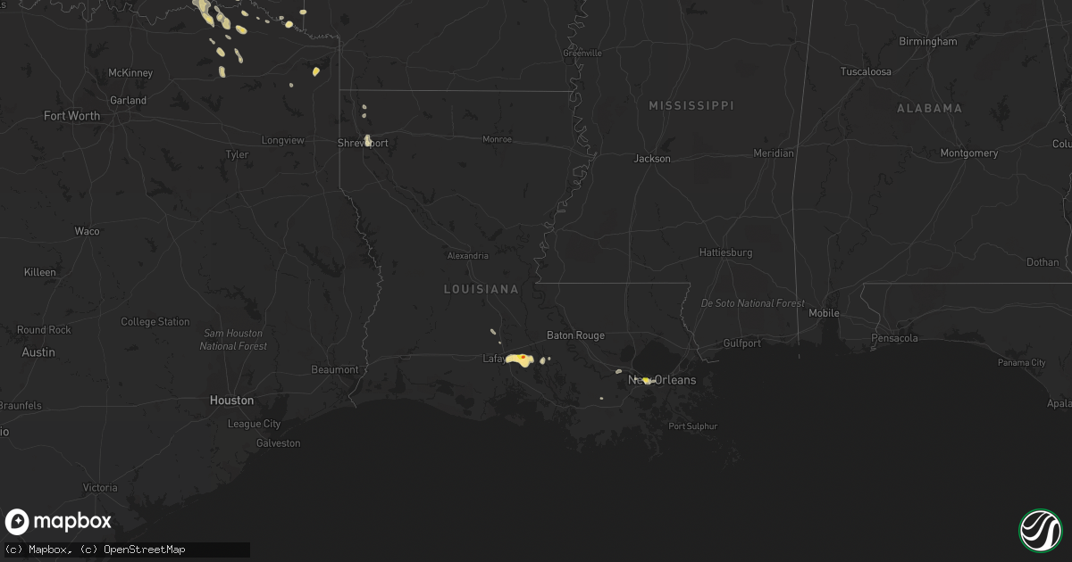
Hail Map in Louisiana on June 5, 2022
Get this storm
June 5 map
$229
one time, instant access
Download today. No call, no setup
Keep the $229
Bought the map and want the full workflow? Apply the entire $229 to a subscription within 7 days. None of it is wasted.
Every map, not just this one
This buys you this map. Subscription and you get every map we run, in the markets you choose from a few cities to whole states to nationwide. Plus real-time alerts the moment a storm fires.
Contact data
Name, contact info, occupancy, even credit band for addresses in the footprint. You go from where it hit to who to call.
Become the source they trust
Unlimited branding weather history reports on demand. You already have the documented answer ready for the property owner, and you are the one who showed up with it.
Property data and RoofTrace estimates
Pull up any address you have got, its value and the exact code rules for that jurisdiction, straight from One Click Code. Then RoofTrace estimates the squares, pitch, and roof value, priced the way you price.
Storm reports in Louisiana
Louisiana
| Date | Description |
|---|---|
| 06/05/20226:20 PM CDT | A local report indicates 1.00 inch wind near PARKS |
| 06/05/20226:15 PM CDT | A local report indicates 1.75 inch wind near 3 E PARKS |
| 06/05/20221:51 AM CDT | At 651 PM CDT, severe thunderstorms were located along a line extending from near Lafayette to Broussard, moving west at 15 mph. HAZARD...60 mph wind gusts and half dollar size hail. SOURCE...Radar indicated. IMPACT...Hail damage to vehicles is expected. Expect wind damage to roofs, siding, and trees. Locations impacted include... Lafayette, Abbeville, Scott, Broussard, Youngsville, Erath, Delcambre, Duson, Maurice, Meaux, Jefferson Island, Indian Bayou, Ridge and Milton.This includes the following highways... Interstate 10 in Louisiana between mile markers 94 and 107. Interstate 49 near mile marker 1. |
| 06/05/20221:14 AM CDT | At 614 PM CDT, severe thunderstorms were located along a line extending from near Breaux Bridge to near Loreauville, moving west at 10 mph. HAZARD...60 mph wind gusts and quarter size hail. SOURCE...Radar indicated. IMPACT...Hail damage to vehicles is expected. Expect wind damage to roofs, siding, and trees. Locations impacted include... New Iberia, Catahoula, Breaux Bridge, St. Martinville, Broussard, Loreauville, Cade, Butte La Rose, Coteau, Acadiana Regional Airport and Parks.This includes Interstate 10 in Louisiana near mile marker 108. |
| 06/04/20228:44 PM CDT | At 143 PM CDT, a severe thunderstorm was located over River Ridge, or near Metairie, moving west at 5 mph. HAZARD...Quarter size hail. SOURCE...Radar indicated. IMPACT...Damage to vehicles is expected. Locations impacted include... Metairie, Avondale, Jefferson, Harahan, Westwego, Elmwood, Bridge City, River Ridge, Ama, Waggaman, St. Rose, Luling, Destrehan and New Orleans Armstrong Airport.This includes the following Interstates... Interstate 10 in Louisiana between mile markers 218 and 229. Interstate 310 between mile markers 1 and 4. |
| 06/04/20227:05 PM CDT | Wire from a powerline reported down on the 1400th block of youngsville hwy. |
All States Impacted by Hail Map on June 5, 2022
Cities Impacted by Hail Map on June 5, 2022
- Paul, ID
- Rupert, ID
- Burley, ID
- Heyburn, ID
- Bingham, NE
- Rushville, NE
- Guthrie Center, IA
- Newton, KS
- Arlington, KS
- Abbyville, KS
- Evergreen, AL
- Hunter, OK
- Bird City, KS
- Lamont, OK
- Edson, KS
- Oklahoma City, OK
- Lucas, KS
- Ashdown, AR
- Chadron, NE
- Hay Springs, NE
- Oelrichs, SD
- Perry, OK
- Gordon, NE
- Uniontown, WA
- Colton, WA
- Boise, ID
- Payette, ID
- Vale, OR
- Ontario, OR
- Wichita, KS
- Marsland, NE
- Wellington, KS
- Valley Center, KS
- Atkinson, NE
- Amelia, NE
- Great Bend, KS
- Ellinwood, KS
- St John, KS
- Hudson, KS
- Hays, KS
- Halsey, NE
- Bridgeport, NE
- Alliance, NE
- Haworth, OK
- Mountain Home, ID
- Hayes Center, NE
- Burlington, CO
- Arapahoe, CO
- Elgin, OR
- Big Springs, NE
- Waterville, WA
- Winterset, IA
- Elm Creek, NE
- Flagler, CO
- Thedford, NE
- Checotah, OK
- Benton, LA
- Bruneau, ID
- Hammett, ID
- King Hill, ID
- Hagerman, ID
- Jerome, ID
- Wendell, ID
- Buhl, ID
- Batesland, SD
- Heppner, OR
- Lexington, OR
- Waukee, IA
- West Des Moines, IA
- Windsor Heights, IA
- Clive, IA
- Urbandale, IA
- Ranchester, WY
- Parkman, WY
- Dayton, WY
- Mullen, NE
- Blue Springs, NE
- Murphy, ID
- Adrian, OR
- Jordan Valley, OR
- Merriman, NE
- Ellis, KS
- Plainville, KS
- McDonald, KS
- Stratton, NE
- Saint Francis, KS
- Max, NE
- Haigler, NE
- Parks, NE
- Benkelman, NE
- Brule, NE
- Ogallala, NE
- Dawson, IA
- Linden, IA
- Yale, IA
- Anthony, KS
- Konawa, OK
- Plummer, ID
- Lewiston, ID
- Vona, CO
- Priest River, ID
- Haven, KS
- Hutchinson, KS
- Stafford, KS
- Detroit, TX
- Clarksville, TX
- Derby, KS
- Scribner, NE
- Deport, TX
- Talco, TX
- Bogata, TX
- Coleman, OK
- Caddo, OK
- Bristow, OK
- Paris, TX
- Atlanta, KS
- Latham, KS
- Boswell, OK
- Van Meter, IA
- Adel, IA
- Booneville, IA
- Pretty Prairie, KS
- Dickens, NE
- Declo, ID
- Lamar, CO
- Holly, CO
- Two Buttes, CO
- Cheyenne Wells, CO
- Walsh, CO
- Sheridan Lake, CO
- Eads, CO
- Granada, CO
- Kit Carson, CO
- Okanogan, WA
- Bridgeport, WA
- Lenora, KS
- Sawyer, KS
- Kechi, KS
- Yoder, WY
- Torrington, WY
- Kamiah, ID
- Weippe, ID
- Spencer, OK
- Arthur City, TX
- Blossom, TX
- Powderly, TX
- Ellsworth, KS
- Goodland, KS
- Brewster, KS
- Winona, KS
- Colby, KS
- Wauneta, NE
- Phillipsburg, KS
- Champion, NE
- Medford, OK
- Caldwell, KS
- Perkins, OK
- Argonia, KS
- Freeport, KS
- Milan, KS
- Delaware, OK
- Allen, SD
- Caldwell, ID
- Melba, ID
- Nampa, ID
- Kuna, ID
- Longton, KS
- Hope, AR
- Bradley, AR
- Opelousas, LA
- Crescent, OK
- Wilmore, KS
- Moscow, ID
- Genesee, ID
- Lincoln, KS
- Duncombe, IA
- Cumming, IA
- Hemingford, NE
- Walker, KS
- Victoria, KS
- Crawford, NE
- Harrison, NE
- Burchard, NE
- Pawnee City, NE
- Du Bois, NE
- Sylvan Grove, KS
- Riverdale, NE
- Kearney, NE
- Oakesdale, WA
- Thornton, WA
- Juliaetta, ID
- Fairmont, NE
- McCool Junction, NE
- Exeter, NE
- Lyman, NE
- Harrisburg, NE
- Liberty, NE
- Fort Scott, KS
- Redfield, KS
- Gibbon, NE
- Ravenna, NE
- Pleasanton, NE
- Anselmo, NE
- Merna, NE
- Sumner, TX
- Hugo, OK
- Aline, OK
- Okeene, OK
- Sun City, KS
- Dacoma, OK
- Protection, KS
- Alva, OK
- Haviland, KS
- Waynoka, OK
- Cleo Springs, OK
- Freedom, OK
- Fairview, OK
- Coldwater, KS
- Chester, OK
- Medicine Lodge, KS
- Mooreland, OK
- Mullinville, KS
- Hardtner, KS
- Isabella, OK
- Carmen, OK
- Lake City, KS
- Maxwell, NE
- Bartley, NE
- Norcatur, KS
- Wellfleet, NE
- Moorefield, NE
- Indianola, NE
- Maywood, NE
- Danbury, NE
- Stockville, NE
- McCook, NE
- Curtis, NE
- Oberlin, KS
- Garden Plain, KS
- Humboldt, KS
- Georgiana, AL
- Forest Home, AL
- Chanute, KS
- Buffalo, KS
- Yates Center, KS
- Benedict, KS
- De Kalb, TX
- Lahoma, OK
- Meno, OK
- Enid, OK
- Carrier, OK
- Kremlin, OK
- Ringwood, OK
- Goltry, OK
- Helena, OK
- Valentine, NE
- Hughes Springs, TX
- Naples, TX
- Wapanucka, OK
- Oconto, NE
- Callaway, NE
- Sedgwick, KS
- Laurel Hill, FL
- Florala, AL
- Lake Creek, TX
- Cooper, TX
- Opp, AL
- Malta, ID
- Plaquemine, LA
- Winter Haven, FL
- Overton, NE
- Loomis, NE
- Bertrand, NE
- Baxley, GA
- Surrency, GA
- Cody, NE
- Whitman, NE
- Palco, KS
- Damar, KS
- Bogue, KS
- Stockton, KS
- Cozad, NE
- Chappell, NE
- Sidney, NE
- Lodgepole, NE
- Mount Hope, KS
- Burrton, KS
- Saint Martinville, LA
- Halstead, KS
- McDavid, FL
- Bentley, KS
- Colwich, KS
- Maize, KS
- Plain Dealing, LA
- Coats, KS
- Yukon, OK
- Edmond, OK
- Jones, OK
- Arcadia, OK
- Guthrie, OK
- Piedmont, OK
- Waukomis, OK
- Maramec, OK
- Jennings, OK
- Foreman, AR
- Spiro, OK
- Dike, TX
- Sulphur Springs, TX
- Westwego, LA
- New Orleans, LA
- Kenner, LA
- Saint Rose, LA
- Metairie, LA
- Ama, LA
- Carrabelle, FL
- Eddyville, NE
- Arnold, NE
- Stapleton, NE
- Broken Bow, NE
- Gothenburg, NE
- Shreveport, LA
- Bossier City, LA
- Barksdale Afb, LA
- Arkansas City, KS
- Newkirk, OK
- Stratford, OK
- Enterprise, AL
- Coalgate, OK
- Douglas, OK
- Eufaula, OK
- Lenapah, OK
- Geuda Springs, KS
- Pond Creek, OK
- Holt, FL
- Marshall, OK
- Stillwater, OK
- Orlando, OK
- Mulhall, OK
- Cashion, OK
- Bagwell, TX
- Carencro, LA
- Ariton, AL
- Burlington, OK
- Natoma, KS
- Prattville, AL
- Vernon, FL
- Glade, KS
- Clearwater, KS
- Haysville, KS
- Dorrance, KS
- Wilson, KS
- Luray, KS
- Paradise, KS
- Russell, KS
- Waldo, KS
- Bunker Hill, KS
- Stonewall, OK
- Milburn, OK
- Kirwin, KS
- Logan, KS
- Braman, OK
- Wellston, OK
- Kingman, KS
- Wakita, OK
- Kaw City, OK
- Shidler, OK
- Coyle, OK
- Missouri Valley, IA
- Honey Creek, IA
- Gorham, KS
- Catharine, KS
- Eustis, NE
- Smithfield, NE
- Elwood, NE
- Willow Island, NE
- Seneca, NE
- Holdrege, NE
- Funk, NE
- Lexington, NE
- Fort Towson, OK
- Eclectic, AL
- Moundridge, KS
- Buhler, KS
- Inman, KS
- Windom, KS
- Little River, KS
- Mcpherson, KS
- Bokchito, OK
- Bennington, OK
- Nash, OK
- Manchester, OK
- Lewisville, AR
- Breaux Bridge, LA
- Creston, IA
- Hoisington, KS
- Prairie View, KS
- Woodston, KS
- Claflin, KS
- Holyrood, KS
- Alton, KS
- Tonkawa, OK
- Douglassville, TX
- Stigler, OK
- Bison, OK
- Julesburg, CO
- Ovid, CO
- Sedgwick, CO
- Elk Falls, KS
- Billings, OK
- Garber, OK
- Ada, OK
- Wanette, OK
- Tupelo, OK
- Centrahoma, OK
- Tecumseh, OK
- Fitzhugh, OK
- Noble, OK
- Norman, OK
- Shawnee, OK
- Fittstown, OK
- Lexington, OK
- Byars, OK
- Roff, OK
- Newalla, OK
- Mcloud, OK
- Atoka, OK
- Macomb, OK
- Asher, OK
- Allen, OK
- Nowata, OK
- Wetumpka, AL
- Kiowa, KS
- Hazelton, KS
- Goddard, KS
- Viola, KS
- Terlton, OK
- Cleveland, OK
- Pattonville, TX
- Waldron, AR
- Hennessey, OK
- Dover, OK
- Andale, KS
- Nickerson, KS
- Lafayette, LA
- Broussard, LA
- Blackwell, OK
- Lorraine, KS
- Geneseo, KS
- Castleberry, AL
- Ames, OK
- Bluff City, KS
- Robertsdale, AL
- Seminole, AL
- Ashton, ID
- Fort Calhoun, NE
- Crescent, IA
- Persia, IA
- Logan, IA
- Omaha, NE
- Norco, LA
- Hahnville, LA
- Destrehan, LA
- Dozier, AL
- Gantt, AL
- Boone, IA
- Madrid, IA
- Woodward, IA
- Lyons, KS
- Mannford, OK
- Sparks, OK
- Chandler, OK
- Stroud, OK
- Edgard, LA
- Reserve, LA
- Mount Airy, LA
- Garyville, LA
- Thibodaux, LA
- Meridian, OK
- Luther, OK
- Lowndesboro, AL
- Montgomery, AL
- Okemah, OK
- Boley, OK
- Castle, OK
- Fulton, AR
- Ogden, AR
- Harper, KS
- Wilder, ID
- Homedale, ID
- Glenns Ferry, ID
- Garden City, ID
- Eagle, ID
- Star, ID
- Venango, NE
- Meridian, ID
- Tensed, ID
- Farmington, WA
- Culdesac, ID
- Lapwai, ID
- Red Rock, OK
- Glencoe, OK
- Morrison, OK
- Skiatook, OK
- Osage, OK
- Owasso, OK
- Tulsa, OK
- Hominy, OK
- Pawnee, OK
- Ralston, OK
- Ponca City, OK
- Fairfax, OK
- Sperry, OK
- Prue, OK
- Sand Springs, OK
- Marland, OK
- Collinsville, OK
- Barnsdall, OK
- Wynona, OK
- Drummond, OK
- Stratton, CO
- Tryon, NE
- Lebanon, NE
- Jennings, KS
- Clarkston, WA
- East Wenatchee, WA


