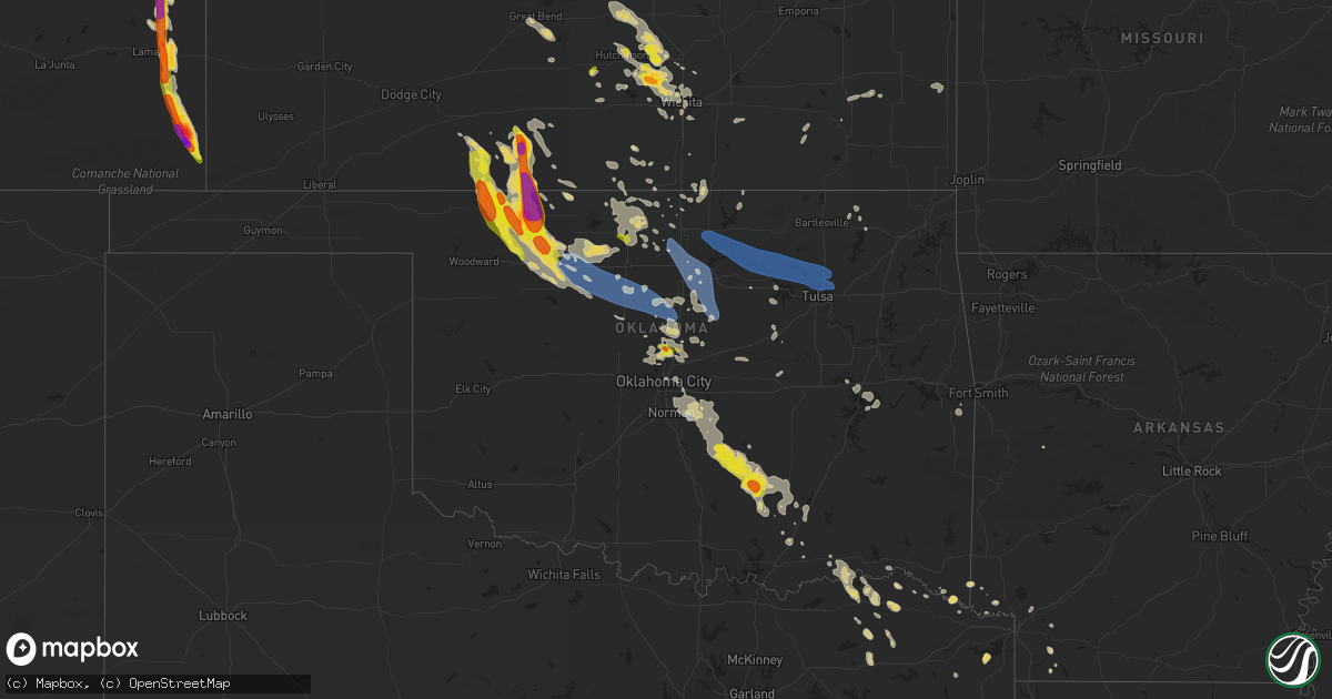
Hail Map on June 5, 2022
Get this storm
June 5 map
$229
one time, instant access
Download today. No call, no setup
Keep the $229
Bought the map and want the full workflow? Apply the entire $229 to a subscription within 7 days. None of it is wasted.
Every map, not just this one
This buys you this map. Subscription and you get every map we run, in the markets you choose from a few cities to whole states to nationwide. Plus real-time alerts the moment a storm fires.
Contact data
Name, contact info, occupancy, even credit band for addresses in the footprint. You go from where it hit to who to call.
Become the source they trust
Unlimited branding weather history reports on demand. You already have the documented answer ready for the property owner, and you are the one who showed up with it.
Property data and RoofTrace estimates
Pull up any address you have got, its value and the exact code rules for that jurisdiction, straight from One Click Code. Then RoofTrace estimates the squares, pitch, and roof value, priced the way you price.
States Impacted by Hail Map on June 5, 2022
Storm reports
Idaho
| Date | Description |
|---|---|
| 06/05/20226:50 PM CDT | Corrects previous hail report from 2 ssw glenns ferry. Via photo on social media. |
| 06/05/20226:30 PM CDT | A local report indicates 1.25 inch wind near 3 E MELBA |
| 06/05/20226:29 PM CDT | Delayed report via social media. |
| 06/05/20225:57 PM CDT | A local report indicates 1.00 inch wind near 17 SE BOISE |
| 06/05/20225:40 PM CDT | Via photo on social media. |
| 06/05/20225:22 PM CDT | Large hail covering the ground. Via social media. |
| 06/05/20225:21 PM CDT | Via social media. |
| 06/05/20225:21 PM CDT | A local report indicates 1.00 inch wind near MELBA |
| 06/05/20224:36 PM CDT | Facebook report showed jagged hail stone with a ruler potentially measuring around 2.1 inches. Car windshield was damaged. Time was estimated when mrms max hail showed |
| 06/05/20224:28 PM CDT | Mostly dime size hail but estimated hail up to the size of quarters. Hail had jagged edges. Put holes in the roof of the chicken loft made of heavy duty semi-clear plas |
| 06/05/20224:28 PM CDT | Corrects previous hail report from woodland. Photo of numerous golf ball sized hail stones in woodland shared via social media. |
| 06/05/20224:28 PM CDT | This report is a correction from the earlier 1.75 inch in woodland proper. Facebook photo with measuring tape revealed at least golf-ball sized hail. They received dent |
| 06/05/20224:25 PM CDT | Facebook photo. |
| 06/05/20224:20 PM CDT | A local report indicates 1.00 inch wind near PAYETTE |
| 06/05/20224:15 PM CDT | A local report indicates 1.00 inch wind near PAYETTE |
| 06/05/20223:37 PM CDT | Corrects previous hail report from 6 nne lapwai. |
| 06/05/20223:28 PM CDT | Photo of numerous golf ball sized hail stones in woodland shared via social media. |
| 06/05/20226:48 AM CDT | At 1148 PM MDT, a severe thunderstorm was located near Tollgate, or 7 miles north of Mountain Home, moving east at 45 mph. HAZARD...Quarter size hail. SOURCE...Radar indicated. IMPACT...Damage to vehicles is expected. This severe thunderstorm will be near... Tollgate around 1150 PM MDT. Bennett Mountain around 1200 AM MDT. Anderson Dam, Cat Creek Summit and Little Camas Reservoir around 1210 AM MDT. Deer Heaven Mountain around 1220 AM MDT. |
| 06/05/20225:47 AM CDT | At 1046 PM MDT, a severe thunderstorm was located near Reynolds, or 23 miles south of Nampa, moving southeast at 40 mph. HAZARD...Quarter size hail. SOURCE...Radar indicated. IMPACT...Damage to vehicles is expected. This severe thunderstorm will be near... Guffey around 1050 PM MDT. Murphy around 1100 PM MDT. Swan Falls around 1110 PM MDT. Big Foot Butte around 1120 PM MDT. Cinder Cone Butte and C J Strike Reservoir around 1130 PM MDT. |
| 06/05/20223:09 AM CDT | At 808 PM MDT, a severe thunderstorm was located near Declo, or 10 miles southeast of Rupert, moving east at 45 mph. HAZARD...60 mph wind gusts and penny size hail. SOURCE...Radar indicated. IMPACT...Expect damage to roofs, siding, and trees. Locations impacted include... Declo, Rockland, Albion, Cold Water Rest Area, Yale Rest Area, Idahome, Sublett Reservoir, Interstate 84 And 86 Junction and Roy. |
| 06/05/20222:07 AM CDT | At 707 PM PDT, a severe thunderstorm was located 11 miles northwest of Ponderay, or 12 miles northwest of Sandpoint, moving east at 25 mph. HAZARD...Quarter size hail. SOURCE...Radar indicated. IMPACT...Damage to vehicles is expected. Locations impacted include... Ponderay, Kootenai, Schweitzer Mountain, Elmira and Colburn. This includes U.S. Highway 95 in Idaho between mile markers 478 and497. |
| 06/05/20221:47 AM CDT | At 647 PM MDT, a severe thunderstorm was located near Minidoka National Monument, or 9 miles east of Jerome, moving east at 40 mph. HAZARD...60 mph wind gusts and quarter size hail. SOURCE...Radar indicated. IMPACT...Hail damage to vehicles is expected. Expect wind damage to roofs, siding, and trees. This severe thunderstorm will be near... Minidoka National Monument around 650 PM MDT. Eden and Hazelton around 700 PM MDT. Milner Dam around 710 PM MDT. |
| 06/05/20221:14 AM CDT | At 613 PM MDT, a severe thunderstorm was located near Wendell, or 12 miles south of Gooding, moving east at 40 mph. HAZARD...60 mph wind gusts and quarter size hail. SOURCE...Radar indicated. IMPACT...Hail damage to vehicles is expected. Expect wind damage to roofs, siding, and trees. Locations impacted include... Twin Falls, Jerome, Wendell and Minidoka National Monument. |
| 06/05/202212:32 AM CDT | At 531 PM PDT, a severe thunderstorm was located 19 miles north of Colfax, or 28 miles north of Pullman, moving northeast at 20 mph. HAZARD...Quarter size hail. SOURCE...Radar indicated. IMPACT...Damage to vehicles is expected. Locations impacted include... Tekoa, Oakesdale, Latah and Tensed. This includes U.S. Highway 95 in Idaho between mile markers 382 and388. |
| 06/05/202212:31 AM CDT | At 530 PM MDT, a severe thunderstorm was located near Danskin Peak, or 14 miles north of Mountain Home, moving east at 30 mph. HAZARD...Quarter size hail. SOURCE...Spotter reports of 1 inch hail. IMPACT...Damage to vehicles is expected. This severe thunderstorm will be near... Anderson Dam and Bennett Mountain around 550 PM MDT. Cat Creek Summit, Little Camas Reservoir and Anderson Ranch Reservoir around 600 PM MDT. Deer Heaven Mountain around 610 PM MDT. |
| 06/05/202212:30 AM CDT | At 530 PM MDT, a severe thunderstorm was located over Deadman Flat, or 9 miles south of Glenns Ferry, moving east at 40 mph. HAZARD...60 mph wind gusts and quarter size hail. SOURCE...Radar indicated. IMPACT...Hail damage to vehicles is expected. Expect wind damage to roofs, siding, and trees. This severe thunderstorm will be near... Twentymile Butte around 540 PM MDT. Bliss around 550 PM MDT. Hagerman around 600 PM MDT. Wendell, Buhl and Filer around 610 PM MDT. |
| 06/05/202212:26 AM CDT | At 526 PM MDT, a severe thunderstorm was located near Dubois, moving east at 30 mph. HAZARD...60 mph wind gusts and quarter size hail. SOURCE...Radar indicated. IMPACT...Hail damage to vehicles is expected. Expect wind damage to roofs, siding, and trees. Locations impacted include... Dubois, Idmon and Kilgore. |
| 06/05/202212:03 AM CDT | Via social media. |
| 06/04/202211:59 PM CDT | Via social media. |
| 06/04/202211:47 PM CDT | At 445 PM MDT, a severe thunderstorm was located over Boise Stage Stop, or 18 miles southeast of Boise, moving east at 35 mph. HAZARD...Quarter size hail. SOURCE...Trained weather spotters. IMPACT...Damage to vehicles is expected. This severe thunderstorm will be near... Danskin Peak around 520 PM MDT. Anderson Dam, Tollgate, Bennett Mountain and Anderson Ranch Reservoir around 530 PM MDT. |
| 06/04/202211:32 PM CDT | At 431 PM PDT, a severe thunderstorm was located near Clarkston Heights-Vineland, or 8 miles west of Clarkston, moving northeast at 15 mph. HAZARD...Quarter size hail. SOURCE...Radar indicated. IMPACT...Damage to vehicles is expected. Locations impacted include... Lewiston, Clarkston, Clarkston Heights-Vineland, West Clarkston-Highland, Asotin, Uniontown, Clarkston Heights and Jerry.This includes the following highways... U.S. Highway 95 in Idaho between mile markers 309 and 314, andbetween mile markers 316 and 324. U.S. Highway 12 in Idaho between mile markers 0 and 3. |
| 06/04/202211:28 PM CDT | At 427 PM PDT, a severe thunderstorm was located near Moscow, moving northeast at 20 mph. HAZARD...Quarter size hail. SOURCE...Radar indicated. IMPACT...Damage to vehicles is expected. Locations impacted include... Troy, Deary, Harvard, Helmer and Joel. This includes U.S. Highway 95 in Idaho between mile markers 334 and335, and between mile markers 339 and 341. |
| 06/04/202211:00 PM CDT | At 400 PM MDT, a severe thunderstorm was located near Kuna, or 12 miles southeast of Nampa, moving east at 50 mph. HAZARD...60 mph wind gusts and quarter size hail. SOURCE...Radar indicated. IMPACT...Hail damage to vehicles is expected. Expect wind damage to roofs, siding, and trees. This severe thunderstorm will be near... Southeastern Boise around 410 PM MDT. Blacks Creek Reservoir, Lucky Peak Dam and Lucky Peak Reservoir around 420 PM MDT. Boise Stage Stop around 430 PM MDT. |
| 06/04/202210:42 PM CDT | At 341 PM PDT, a severe thunderstorm was located 8 miles northwest of Clarkston, moving northeast at 20 mph. HAZARD...Quarter size hail. SOURCE...Radar indicated. IMPACT...Damage to vehicles is expected. Locations impacted include... Pullman, Moscow, Genesee, Colton, Uniontown and Joel. This includes U.S. Highway 95 in Idaho between mile markers 319 and326, and between mile markers 329 and 352. |
| 06/04/202210:11 PM CDT | At 311 PM MDT, a severe thunderstorm was located near Roseworth, or 27 miles west of Twin Falls, moving east at 30 mph. HAZARD...60 mph wind gusts and quarter size hail. SOURCE...Radar indicated. IMPACT...Hail damage to vehicles is expected. Expect wind damage to roofs, siding, and trees. This severe thunderstorm will be near... Castleford around 320 PM MDT. Hollister around 350 PM MDT. Twin Falls and Magic Valley Regional Airport around 400 PM MDT. |
| 06/04/202210:10 PM CDT | At 309 PM MDT, a severe thunderstorm was located near Payette, moving east at 35 mph. HAZARD...60 mph wind gusts and quarter size hail. SOURCE...Radar indicated. IMPACT...Hail damage to vehicles is expected. Expect wind damage to roofs, siding, and trees. Locations impacted include... Payette, Weiser, Fruitland, Paddock Valley Reservoir, Presley Bridge, French Corner and Crane Creek Reservoir. |
| 06/04/20229:33 PM CDT | At 233 PM MDT, a severe thunderstorm was located near Vale, or 10 miles west of Ontario, moving east at 30 mph. HAZARD...60 mph wind gusts and quarter size hail. SOURCE...Radar indicated. IMPACT...Hail damage to vehicles is expected. Expect wind damage to roofs, siding, and trees. This severe thunderstorm will be near... Moores Hollow around 240 PM MDT. Ontario around 250 PM MDT. Payette, Weiser, Fruitland and Annex around 300 PM MDT. |
| 06/04/20228:55 PM CDT | Time estimated from radar. |
| 06/04/20228:46 PM CDT | Video of hail up to quarter size covering state route 57 southwest of coolin. Time estimated from radar. Report via social media. |
| 06/04/20228:08 PM CDT | A local report indicates 1.00 inch wind near ASHTON |
| 06/04/20227:30 PM CDT | A local report indicates 1.00 inch wind near WENDELL |
| 06/04/20227:30 PM CDT | Via photo on social media. |
| 06/04/20227:15 PM CDT | A local report indicates 1.25 inch wind near WENDELL |
| 06/04/20227:12 PM CDT | Multiple social media reports and photos of 1.0 inch hail. |
| 06/04/20227:00 PM CDT | Via social media. |
Colorado
| Date | Description |
|---|---|
| 06/05/20226:40 PM CDT | Hailstones measured in picture... Likely after some melting. |
| 06/05/20226:35 PM CDT | A local report indicates 1.00 inch wind near 1 NE BRANDON |
| 06/05/20226:17 PM CDT | A local report indicates 63 MPH wind near 4 WSW LAMAR |
| 06/05/20226:15 PM CDT | Report from mping: ping pong ball |
| 06/05/20226:13 PM CDT | Picture of measurement of multiple hailstones confirmed on social media. |
| 06/05/20225:47 PM CDT | Public reported quarter-size hail with severe storm that moved through the area. |
| 06/05/20225:21 PM CDT | Corrects time of previous hail report from 1 ne brandon. |
| 06/05/20224:56 PM CDT | Most stones around 1 inch with no rain attm. |
| 06/05/20224:36 PM CDT | Trained spotter reported quarter sized hail. |
| 06/05/20226:20 AM CDT | At 1119 PM MDT, a severe thunderstorm was located near Lodgepole, or 12 miles west of Chappell, moving southeast at 35 mph. HAZARD...60 mph wind gusts and quarter size hail. SOURCE...Radar indicated. IMPACT...Hail damage to vehicles is expected. Expect wind damage to roofs, siding, and trees. Locations impacted include... Chappell.This includes Interstate 80 in Nebraska between mile markers 78 and95. |
| 06/05/20226:03 AM CDT | At 1103 PM MDT, a severe thunderstorm was located near Colton, or near Sidney, moving east at 30 mph. HAZARD...60 mph wind gusts and quarter size hail. SOURCE...Radar indicated. IMPACT...Hail damage to vehicles is expected. Expect wind damage to roofs, siding, and trees. Locations impacted include... Lodgepole, Colton and Sunol. This includes Interstate 80 in Nebraska between mile markers 63 and77. |
| 06/05/202212:54 AM CDT | At 553 PM MDT, a severe thunderstorm was located 13 miles northeast of Two Buttes Reservoir, or 24 miles southeast of Lamar, moving south at 40 mph. HAZARD...Golf ball size hail and 70 mph wind gusts. SOURCE...Radar indicated. IMPACT...People and animals outdoors will be injured. Expect hail damage to roofs, siding, windows, and vehicles. Expect considerable tree damage. Wind damage is also likely to mobile homes, roofs, and outbuildings. This severe thunderstorm will be near... Two Buttes around 615 PM MDT. Walsh around 635 PM MDT. Stonington around 650 PM MDT. |
| 06/04/202211:59 PM CDT | At 459 PM MDT, a severe thunderstorm was located 8 miles northeast of Lamar, moving south at 35 mph. HAZARD...Tennis ball size hail and 70 mph wind gusts. SOURCE...Radar indicated. IMPACT...People and animals outdoors will be injured. Expect hail damage to roofs, siding, windows, and vehicles. Expect considerable tree damage. Wind damage is also likely to mobile homes, roofs, and outbuildings. Locations impacted include... Lamar, Granada, Bristol and Two Buttes Reservoir. |
| 06/04/202211:15 PM CDT | At 415 PM MDT, a severe thunderstorm was located over Brandon, or 23 miles south of Cheyenne Wells, moving south at 25 mph. HAZARD...Tennis ball size hail and 60 mph wind gusts. SOURCE...Radar indicated. IMPACT...People and animals outdoors will be injured. Expect hail damage to roofs, siding, windows, and vehicles. Expect wind damage to roofs, siding, and trees. This severe thunderstorm will be near... Bristol around 520 PM MDT. Hartman around 525 PM MDT. Granada and Lamar around 530 PM MDT. Holly around 540 PM MDT. |
| 06/04/202210:52 PM CDT | At 351 PM MDT, a severe thunderstorm was located 12 miles north of Brandon, or 15 miles southwest of Cheyenne Wells, moving southeast at 20 mph. THIS IS A DESTRUCTIVE STORM FOR SHERIDAN LAKE, BRANDON, AND CHIVINGTON. HAZARD...Three inch hail and 60 mph wind gusts. SOURCE...Radar indicated. IMPACT...People and animals outdoors will be severely injured. Expect shattered windows, extensive damage to roofs, siding, and vehicles. Locations impacted include... Brandon, Chivington, and Sheridan Lake. |
| 06/04/202210:41 PM CDT | At 340 PM MDT, a severe thunderstorm was located over Stratton, moving east at 20 mph. HAZARD...Quarter size hail. SOURCE...Trained weather spotters. IMPACT...Damage to vehicles is expected. Locations impacted include... Bethune.This includes Interstate 70 in Colorado between mile markers 416 and433. |
| 06/04/202210:28 PM CDT | At 328 PM MDT, a severe thunderstorm was located 10 miles northeast of Kit Carson, or 15 miles west of Cheyenne Wells, moving southeast at 30 mph. HAZARD...60 mph wind gusts and half dollar size hail. SOURCE...Radar indicated. IMPACT...Hail damage to vehicles is expected. Expect wind damage to roofs, siding, and trees. This severe thunderstorm will remain over mainly rural areas of central Cheyenne County in east central Colorado, including the following locations... Firstview.This includes Highway 385 between mile markers 136 and 142. |
| 06/04/20229:38 PM CDT | Post on twitter with a picture of a heavily damaged windshield. |
| 06/04/20227:59 PM CDT | A local report indicates 1.00 inch wind near 4 SE STONINGTON |
| 06/04/20227:57 PM CDT | A local report indicates 1.50 inch wind near 1 NE WALSH |
| 06/04/20227:45 PM CDT | Corrects previous hail report from walsh. Post on twitter with a picture of a heavily damaged windshield. |
| 06/04/20227:44 PM CDT | A local report indicates 1.75 inch wind near 2 E WALSH |
| 06/04/20227:38 PM CDT | A local report indicates 1.75 inch wind near 3 S TWO BUTTES |
Louisiana
| Date | Description |
|---|---|
| 06/05/20226:20 PM CDT | A local report indicates 1.00 inch wind near PARKS |
| 06/05/20226:15 PM CDT | A local report indicates 1.75 inch wind near 3 E PARKS |
| 06/05/20221:51 AM CDT | At 651 PM CDT, severe thunderstorms were located along a line extending from near Lafayette to Broussard, moving west at 15 mph. HAZARD...60 mph wind gusts and half dollar size hail. SOURCE...Radar indicated. IMPACT...Hail damage to vehicles is expected. Expect wind damage to roofs, siding, and trees. Locations impacted include... Lafayette, Abbeville, Scott, Broussard, Youngsville, Erath, Delcambre, Duson, Maurice, Meaux, Jefferson Island, Indian Bayou, Ridge and Milton.This includes the following highways... Interstate 10 in Louisiana between mile markers 94 and 107. Interstate 49 near mile marker 1. |
| 06/05/20221:14 AM CDT | At 614 PM CDT, severe thunderstorms were located along a line extending from near Breaux Bridge to near Loreauville, moving west at 10 mph. HAZARD...60 mph wind gusts and quarter size hail. SOURCE...Radar indicated. IMPACT...Hail damage to vehicles is expected. Expect wind damage to roofs, siding, and trees. Locations impacted include... New Iberia, Catahoula, Breaux Bridge, St. Martinville, Broussard, Loreauville, Cade, Butte La Rose, Coteau, Acadiana Regional Airport and Parks.This includes Interstate 10 in Louisiana near mile marker 108. |
| 06/04/20228:44 PM CDT | At 143 PM CDT, a severe thunderstorm was located over River Ridge, or near Metairie, moving west at 5 mph. HAZARD...Quarter size hail. SOURCE...Radar indicated. IMPACT...Damage to vehicles is expected. Locations impacted include... Metairie, Avondale, Jefferson, Harahan, Westwego, Elmwood, Bridge City, River Ridge, Ama, Waggaman, St. Rose, Luling, Destrehan and New Orleans Armstrong Airport.This includes the following Interstates... Interstate 10 in Louisiana between mile markers 218 and 229. Interstate 310 between mile markers 1 and 4. |
| 06/04/20227:05 PM CDT | Wire from a powerline reported down on the 1400th block of youngsville hwy. |
Oklahoma
| Date | Description |
|---|---|
| 06/05/20223:22 PM CDT | 54 mph wind gust in haworth with widespread power outages. |
| 06/05/20226:55 AM CDT | At 1155 PM CDT, a severe thunderstorm was located 8 miles west of Aline, moving southeast at 30 mph. HAZARD...60 mph wind gusts and half dollar size hail. SOURCE...Radar indicated. IMPACT...Hail damage to vehicles is expected. Expect wind damage to roofs, siding, and trees. Locations impacted include... Fairview, Cleo Springs, Aline and Orienta. |
| 06/05/20226:39 AM CDT | At 1139 PM CDT, a severe thunderstorm was located near Lake Coldwater, moving southeast at 25 mph. HAZARD...Half dollar size hail. SOURCE...Public reported quarter to half dollar sized hail in Coldwater at 1137 PM. IMPACT...Damage to vehicles is expected. This severe thunderstorm will be near... Buttermilk around 1150 PM CDT. |
| 06/05/20226:39 AM CDT | At 1139 AM CDT, severe thunderstorms were located along a line extending from near Stonewall to 6 miles northwest of Pontotoc, moving southeast at 35 mph. HAZARD...60 mph wind gusts and quarter size hail. SOURCE...Radar indicated. IMPACT...Hail damage to vehicles is expected. Expect wind damage to roofs, siding, and trees. Locations impacted include... Atoka, Coalgate, Stonewall, Wapanucka, Stringtown, Lehigh, Tupelo, Bromide, Centrahoma, Pontotoc, Fittstown, Clarita, Olney, Fillmore, Connerville, Coleman, Phillips, southwestern Atoka Reservoir and Jesse. |
| 06/05/20226:12 AM CDT | At 1112 AM CDT, a severe thunderstorm was located near Vanoss, moving southeast at 35 mph. HAZARD...60 mph wind gusts and quarter size hail. SOURCE...Radar indicated. IMPACT...Hail damage to vehicles is expected. Expect wind damage to roofs, siding, and trees. Locations impacted include... Ada, Roff, Stonewall, Fitzhugh, Fittstown and Vanoss. |
| 06/05/20225:54 AM CDT | At 1054 PM CDT, a severe thunderstorm was located 7 miles northwest of Avard, moving south at 30 mph. HAZARD...Two inch hail and 70 mph wind gusts. SOURCE...Radar indicated. IMPACT...People and animals outdoors will be injured. Expect hail damage to roofs, siding, windows, and vehicles. Expect considerable tree damage. Wind damage is also likely to mobile homes, roofs, and outbuildings. Locations impacted include... Alva, Waynoka, Dacoma, Avard, Bouse Junction and Hopeton. |
| 06/05/20224:59 AM CDT | At 959 AM CDT, a severe thunderstorm was located over northeastern Norman, or near Stanley Draper Lake, moving southeast at 20 mph. HAZARD...60 mph wind gusts and quarter size hail. SOURCE...Radar indicated. IMPACT...Hail damage to vehicles is expected. Expect wind damage to roofs, siding, and trees. Locations impacted include... Eastern Norman, Pink, Tribbey, Etowah, Macomb, Stella, Lake Thunderbird and Little Axe. |
| 06/05/20224:41 AM CDT | Spotternetwork report. Time is radar estimated. |
| 06/05/20224:30 AM CDT | At 930 AM CDT, a severe thunderstorm was located 5 miles northwest of Edmond, or 4 miles south of Seward, moving east at 15 mph. HAZARD...60 mph wind gusts and quarter size hail. SOURCE...Radar indicated. IMPACT...Hail damage to vehicles is expected. Expect wind damage to roofs, siding, and trees. Locations impacted include... Northern Edmond and Arcadia. |
| 06/05/20224:15 AM CDT | Nwschat report |
| 06/05/20224:08 AM CDT | At 908 AM CDT, a severe thunderstorm was located 8 miles west of Edmond, or 5 miles northwest of Downtown Edmond, moving east at 15 mph. HAZARD...60 mph wind gusts and quarter size hail. SOURCE...Radar indicated. IMPACT...Hail damage to vehicles is expected. Expect wind damage to roofs, siding, and trees. Locations impacted include... Northern Oklahoma City, Edmond, Jones and Arcadia. |
| 06/05/20223:18 AM CDT | At 818 AM CDT, a severe thunderstorm was located over northern Oklahoma City, or near Downtown Edmond, moving east at 20 mph. HAZARD...60 mph wind gusts and quarter size hail. SOURCE...Radar indicated. IMPACT...Hail damage to vehicles is expected. Expect wind damage to roofs, siding, and trees. Locations impacted include... Northeastern Oklahoma City, Edmond, Choctaw, The Village, Harrah, Spencer, Jones, Luther and Arcadia. |
| 06/05/20222:29 AM CDT | Several trees down. |
| 06/05/20222:00 AM CDT | Corrects previous non-tstm wnd dmg report from 1 ene hennessey. Mping report. Small branches broken. |
| 06/05/20221:58 AM CDT | At 658 AM CDT, a severe thunderstorm was located near Kremlin, moving southeast at 35 mph. HAZARD...60 mph wind gusts and quarter size hail. SOURCE...Radar indicated. IMPACT...Hail damage to vehicles is expected. Expect wind damage to roofs, siding, and trees. Locations impacted include... Enid, Pond Creek, Garber, Covington, Kremlin, Breckenridge, Hunter, Fairmont, Douglas and North Enid. |
| 06/05/20221:43 AM CDT | A local report indicates 1.00 inch wind near FREEDOM |
| 06/05/20221:36 AM CDT | At 636 PM MDT, a severe thunderstorm was located over Walsh, or 12 miles southwest of The Saunders Elevator, moving south at 45 mph. HAZARD...Tennis ball size hail and 70 mph wind gusts. SOURCE...Radar indicated. IMPACT...People and animals outdoors will be injured. Expect hail damage to roofs, siding, windows, and vehicles. Expect considerable tree damage. Wind damage is also likely to mobile homes, roofs, and outbuildings. This severe thunderstorm will remain over mainly rural areas of southeastern Baca County. |
| 06/05/20221:35 AM CDT | A local report indicates 64 MPH wind near 2 W STILLWATER |
| 06/05/20221:33 AM CDT | At 633 AM CDT, a severe thunderstorm was located 5 miles north of Nash, moving southeast at 30 mph. HAZARD...60 mph wind gusts and quarter size hail. SOURCE...Radar indicated. IMPACT...Hail damage to vehicles is expected. Expect wind damage to roofs, siding, and trees. Locations impacted include... Cherokee, Pond Creek, Goltry, Jet, Nash, Hillsdale, Jefferson and Great Salt Plains Lake. |
| 06/05/20221:10 AM CDT | A local report indicates 60 MPH wind near 7 SW SOONER LAKE |
| 06/05/202212:54 AM CDT | Received a report of thunderstorm damage... Not sure the severity of the damage. |
| 06/05/202212:25 AM CDT | At 524 AM CDT, a severe thunderstorm was located near Nash, moving southeast at 25 mph. HAZARD...60 mph wind gusts and quarter size hail. SOURCE...Radar indicated. IMPACT...Hail damage to vehicles is expected. Expect wind damage to roofs, siding, and trees. Locations impacted include... Kremlin, Jet, Nash, Hillsdale, Carrier, Amorita, Byron and Great Salt Plains Lake. |
| 06/05/202212:06 AM CDT | At 506 AM CDT, a severe thunderstorm was located near Great Salt Plains Lake, moving southeast at 35 mph. HAZARD...60 mph wind gusts and quarter size hail. SOURCE...Radar indicated. IMPACT...Hail damage to vehicles is expected. Expect wind damage to roofs, siding, and trees. Locations impacted include... Jet, Nash, Byron and Great Salt Plains Lake. |
| 06/04/202211:08 PM CDT | A local report indicates 2.00 inch wind near 8 NNW AVARD |
| 06/04/202210:33 PM CDT | At 333 PM CDT, a severe thunderstorm was located 10 miles north of De Kalb, or 12 miles west of Foreman, moving southeast at 40 mph. HAZARD...60 mph wind gusts and quarter size hail. SOURCE...Radar indicated. IMPACT...Hail damage to vehicles is expected. Expect wind damage to roofs, siding, and trees. Locations impacted include... New Boston, Foreman, Hooks, De Kalb, Richmond, Leary, Almont, Beaverdams, Goodlake, Wallace, Tom, Red Bank and Pine Prairie. |
South Dakota
| Date | Description |
|---|---|
| 06/05/20227:59 AM CDT | At 1257 PM MDT, a severe thunderstorm was located 12 miles southeast of Wounded Knee, or 12 miles north of Gordon, moving east at 10 mph. HAZARD...60 mph wind gusts and half dollar size hail. SOURCE...Radar indicated. IMPACT...Hail damage to vehicles is expected. Expect wind damage to roofs, siding, and trees. Locations impacted include... Hoover Lake. |
| 06/04/202210:08 PM CDT | At 308 PM MDT, a severe thunderstorm was located near Slim Butte, or 13 miles north of Chadron, moving southeast at 25 mph. HAZARD...60 mph wind gusts and quarter size hail. SOURCE...Radar indicated. IMPACT...Hail damage to vehicles is expected. Expect wind damage to roofs, siding, and trees. This severe thunderstorm will remain over mainly rural areas of northeastern Dawes County. |
Nebraska
| Date | Description |
|---|---|
| 06/05/20226:58 PM CDT | A local report indicates 1.00 inch wind near 12 ENE STAPLETON |
| 06/05/20226:50 PM CDT | Started as pea size and reached quarter size hail |
| 06/05/20226:40 PM CDT | Report via social media about 20 minutes after hail fell. |
| 06/05/20226:35 PM CDT | A local report indicates 1.00 inch wind near 16 N STAPLETON |
| 06/05/20226:29 PM CDT | A local report indicates 1.75 inch wind near 4 NW CALLAWAY |
| 06/05/20226:28 PM CDT | Hail to half dollar size fell for 15 minutes that broke numerous windshields and windows of homes in callaway. Siding on homes sustained damage as well. |
| 06/05/20226:28 PM CDT | Homes in callaway sustained hail damage to windows on the north and northeast sides of homes. Largest hail stones the size of baseballs. The hail fell for 15 minutes. |
| 06/05/20226:13 PM CDT | Quarter to half dollar size hail covering the ground. |
| 06/05/20225:11 PM CDT | Tents destroyed at art fair. |
| 06/05/20225:03 PM CDT | Landspout touched down in open field for a minute then lifted. No damage reported. |
| 06/05/20224:50 PM CDT | Quarter to half dollar size hail covering most of the ground. |
| 06/05/20224:26 PM CDT | Large hail falling most the size of quarters.hail forlast 10 minutes. |
| 06/05/20226:56 AM CDT | At 1156 PM CDT, a severe thunderstorm was located 4 miles southwest of Lebanon, or 15 miles northeast of Oberlin, moving south at 20 mph. HAZARD...Ping pong ball size hail. SOURCE...Radar indicated. IMPACT...People and animals outdoors will be injured. Expect damage to roofs, siding, windows, and vehicles. Locations impacted include... Norcatur, Clayton, Jennings and Lenora. |
| 06/05/20226:32 AM CDT | At 1131 PM MDT, a severe thunderstorm was located 5 miles southwest of Chappell, moving southeast at 40 mph. HAZARD...Golf ball size hail and 60 mph wind gusts. SOURCE...Radar indicated. IMPACT...Expect damage to roofs, siding, and trees. People and animals outdoors will be injured. Expect hail damage to roofs, siding, windows, and vehicles. This severe thunderstorm will be near... Ovid around 1145 PM MDT.Other locations in the path of this severe thunderstorm includeJulesburg. |
| 06/05/20224:22 AM CDT | At 922 PM MDT, a severe thunderstorm was located 7 miles west of Wildcat Hills Campground, or 15 miles southwest of Scottsbluff, moving southeast at 30 mph. HAZARD...Ping pong ball size hail and 60 mph wind gusts. SOURCE...Radar indicated. IMPACT...People and animals outdoors will be injured. Expect hail damage to roofs, siding, windows, and vehicles. Expect wind damage to roofs, siding, and trees. Locations impacted include... Harrisburg. |
| 06/05/20224:03 AM CDT | At 903 PM CDT, a severe thunderstorm was located 7 miles north of Holdrege, moving southeast at 20 mph. HAZARD...60 mph wind gusts and quarter size hail. SOURCE...Radar indicated. IMPACT...Hail damage to vehicles is expected. Expect wind damage to roofs, siding, and trees. This severe thunderstorm will be near... Holdrege around 920 PM CDT.Other locations in the path of this severe thunderstorm include Funk,Axtell, Wilcox and Ragan. |
| 06/05/20223:30 AM CDT | At 830 PM CDT, a severe thunderstorm was located 4 miles northwest of Danbury, or 12 miles southeast of McCook, moving southeast at 25 mph. HAZARD...Ping pong ball size hail and 60 mph wind gusts. SOURCE...Radar indicated. IMPACT...People and animals outdoors will be injured. Expect hail damage to roofs, siding, windows, and vehicles. Expect wind damage to roofs, siding, and trees. This severe thunderstorm will be near... Danbury around 840 PM CDT. Lebanon around 850 PM CDT.Other locations in the path of this severe thunderstorm includeNorcatur. |
| 06/05/20223:23 AM CDT | At 822 PM CDT, a severe thunderstorm was located near Overton, or 8 miles east of Lexington, moving southeast at 20 mph. HAZARD...Golf ball size hail and 60 mph wind gusts. SOURCE...Trained weather spotters. IMPACT...People and animals outdoors will be injured. Expect hail damage to roofs, siding, windows, and vehicles. Expect wind damage to roofs, siding, and trees. This severe thunderstorm will be near... Overton around 830 PM CDT.Other locations in the path of this severe thunderstorm include ElmCreek and Odessa.This includes Interstate 80 between mile markers 231 and 266. |
| 06/05/20222:55 AM CDT | 8x10ft tin shed blew across the yard... With wind damage reported. Pea size hail was observed with up to 6 inch drifts. Corrected date. |
| 06/05/20222:44 AM CDT | At 744 PM CDT, severe thunderstorms were located along a line extending from near Eddyville to near Lexington, moving southeast at 20 mph. HAZARD...60 mph wind gusts and quarter size hail. SOURCE...Trained weather spotters. IMPACT...Hail damage to vehicles is expected. Expect wind damage to roofs, siding, and trees. Severe thunderstorms will be near... Lexington around 755 PM CDT. Sumner around 800 PM CDT.Other locations in the path of these severe thunderstorms includeMiller, Overton and Amherst.This includes Interstate 80 between mile markers 211 and 254. |
| 06/05/20222:25 AM CDT | At 724 PM CDT, severe thunderstorms were located along a line extending from 3 miles southeast of Stockville to 10 miles northeast of Culbertson, moving southeast at 35 mph. HAZARD...60 mph wind gusts and half dollar size hail. SOURCE...Radar indicated. IMPACT...Hail damage to vehicles is expected. Expect wind damage to roofs, siding, and trees. Locations impacted include... McCook and Indianola. |
| 06/05/20222:10 AM CDT | Window and fence damage. Corrected date |
| 06/05/20222:07 AM CDT | At 707 PM CDT, severe thunderstorms were located along a line extending from Oconto to near Cozad to near Stockville, moving east at 30 mph. HAZARD...Quarter size hail. SOURCE...Radar indicated. IMPACT...Damage to vehicles is expected. Severe thunderstorms will be near... Cozad around 710 PM CDT.Other locations in the path of these severe thunderstorms includeLexington.This includes Interstate 80 between mile markers 209 and 239. |
| 06/05/20222:03 AM CDT | Estimated under golfball size hail with mostly quarter size and 3 to 4 ft drifts reported. 60 mph winds observed. Wheat crops destroyed and windows were broken. Correct |
| 06/05/20221:58 AM CDT | At 658 PM CDT, a severe thunderstorm was located 8 miles northeast of Gandy, or 11 miles east of Stapleton, moving southeast at 40 mph. HAZARD...Ping pong ball size hail and 60 mph wind gusts. SOURCE...Radar indicated. IMPACT...People and animals outdoors will be injured. Expect hail damage to roofs, siding, windows, and vehicles. Expect wind damage to roofs, siding, and trees. Locations impacted include... Broken Bow, Stapleton, Arnold, Callaway, Gandy, Logan, Shanklin Bluff, Tarboz Lake, Pleasant Hill, Hoagland, Milldale and Finchville.This includes the following highways... Highway 2 between mile markers 272 and 277. Highway 92 between mile markers 236 and 270. Highway 83 near mile marker 112. |
| 06/05/20221:45 AM CDT | At 644 PM CDT, a severe thunderstorm was located near Callaway, or 16 miles southwest of Broken Bow, moving southeast at 25 mph. HAZARD...Golf ball size hail and 60 mph wind gusts. SOURCE...Radar indicated. IMPACT...People and animals outdoors will be injured. Expect hail damage to roofs, siding, windows, and vehicles. Expect wind damage to roofs, siding, and trees. Locations impacted include... Callaway, Oconto, Buckeye, Block Hill Basin, Pressey State Wildlife Management Area, Milldale, Burr Oak, Finchville, Lodi, Intersection of Highway 183 and Cumro Road and Cumro.This includes Highway 183 between mile markers 73 and 84. |
| 06/05/20221:42 AM CDT | At 642 PM CDT, severe thunderstorms were located along a line extending from 9 miles northeast of Moorefield to near Curtis, moving southeast at 25 mph. HAZARD...Ping pong ball size hail and 60 mph wind gusts. SOURCE...Radar indicated. IMPACT...People and animals outdoors will be injured. Expect hail damage to roofs, siding, windows, and vehicles. Expect wind damage to roofs, siding, and trees. Locations impacted include... Curtis, Eustis, Moorefield, Stockville, Medicine Creek Reservoir State Recreation Area, Maywood, Hansen Memorial Reserve State Wildlife Management Area, Orafino, Freedom and Dancing Leaf Earth Lodge.This includes Highway 83 between mile markers 37 and 53. |
| 06/05/20221:13 AM CDT | At 612 PM CDT, a severe thunderstorm was located 14 miles south of Thedford, moving southeast at 45 mph. HAZARD...60 mph wind gusts and quarter size hail. SOURCE...Radar indicated. IMPACT...Hail damage to vehicles is expected. Expect wind damage to roofs, siding, and trees. Locations impacted include... Stapleton, Gandy, Logan, Highway 83 crossing The Dismal River, Shanklin Bluff, Tarboz Lake, Hoagland and Brown Lake.This includes the following highways... Highway 92 between mile markers 226 and 228, and between milemarkers 235 and 239. Highway 83 between mile markers 110 and 143. |
| 06/05/20221:04 AM CDT | At 604 PM CDT, a severe thunderstorm was located 10 miles northeast of Arnold, or 22 miles east of Stapleton, moving southeast at 30 mph. HAZARD...Ping pong ball size hail and 60 mph wind gusts. SOURCE...Radar indicated. IMPACT...People and animals outdoors will be injured. Expect hail damage to roofs, siding, windows, and vehicles. Expect wind damage to roofs, siding, and trees. Locations impacted include... Arnold and Pleasant Hill. This includes Highway 92 between mile markers 247 and 270. |
| 06/05/202212:46 AM CDT | At 546 PM CDT, a severe thunderstorm was located over Callaway, or 15 miles southwest of Broken Bow, moving southeast at 20 mph. HAZARD...Golf ball size hail and 60 mph wind gusts. SOURCE...Radar indicated. IMPACT...People and animals outdoors will be injured. Expect hail damage to roofs, siding, windows, and vehicles. Expect wind damage to roofs, siding, and trees. Locations impacted include... Callaway, Oconto, Buckeye, Pressey State Wildlife Management Area, Milldale, Finchville and Lodi. |
| 06/05/202212:33 AM CDT | At 532 PM CDT, a severe thunderstorm was located 11 miles southwest of Dunning, or 20 miles northeast of Stapleton, moving east at 20 mph. HAZARD...Ping pong ball size hail and 60 mph wind gusts. SOURCE...Radar indicated. IMPACT...People and animals outdoors will be injured. Expect hail damage to roofs, siding, windows, and vehicles. Expect wind damage to roofs, siding, and trees. Locations impacted include... Linscott.This includes Highway 2 between mile markers 241 and 255. |
| 06/05/202212:29 AM CDT | At 528 PM CDT/428 PM MDT/, severe thunderstorms were located along a line extending from 9 miles southwest of Brownlee to near Mullen, moving southeast at 30 mph. HAZARD...60 mph wind gusts and quarter size hail. SOURCE...Radar indicated. IMPACT...Hail damage to vehicles is expected. Expect wind damage to roofs, siding, and trees. Locations impacted include... Mullen, Thedford, Seneca, Norway, Highway 97 crossing the Dismal River, Giant Hill, Natwick, Kelso and Shimmons Lake.This includes the following highways... Highway 2 between mile markers 178 and 217. Highway 97 between mile markers 45 and 50, and between mile markers52 and 77. Highway 83 between mile markers 142 and 162. |
| 06/05/202212:25 AM CDT | Social media report |
| 06/05/202212:03 AM CDT | At 503 PM CDT, a severe thunderstorm was located 7 miles north of Callaway, or 15 miles west of Broken Bow, moving northeast at 15 mph. HAZARD...60 mph wind gusts and half dollar size hail. SOURCE...Radar indicated. IMPACT...Hail damage to vehicles is expected. Expect wind damage to roofs, siding, and trees. Locations impacted include... Merna and Milldale. This includes the following highways... Highway 2 between mile markers 266 and 273. Highway 92 between mile markers 267 and 273. |
| 06/04/202211:50 PM CDT | At 450 PM CDT/350 PM MDT/, a severe thunderstorm was located 16 miles northwest of Mullen, moving southeast at 30 mph. HAZARD...Golf ball size hail and 60 mph wind gusts. SOURCE...Radar indicated. IMPACT...People and animals outdoors will be injured. Expect hail damage to roofs, siding, windows, and vehicles. Expect wind damage to roofs, siding, and trees. Locations impacted include... Mullen, Giant Hill, Marsh Flat, Highway 97 crossing Big Creek, Sevenmile Hill and Kelso.This includes the following highways... Highway 2 between mile markers 180 and 191. Highway 97 between mile markers 62 and 88. |
| 06/04/202210:39 PM CDT | Harrisburg... Ne awos reports gust of 54 knots at site k1cw |
| 06/04/202210:04 PM CDT | At 304 PM MDT, a severe thunderstorm was located 16 miles south of Medicine Lake, or 38 miles northwest of Mullen, moving southeast at 20 mph. HAZARD...Ping pong ball size hail and 60 mph wind gusts. SOURCE...Radar indicated. IMPACT...People and animals outdoors will be injured. Expect hail damage to roofs, siding, windows, and vehicles. Expect wind damage to roofs, siding, and trees. Locations impacted include... Sevenmile Hill, Round Lake and Speckel Meir Lake. |
| 06/04/20228:30 PM CDT | Golf ball sized hail reported at location via social media. |
| 06/04/20228:26 PM CDT | Corrects previous hail report from 4 s mccook. Few hailstone reported at location via social media that were about 2/3rds the size of a dollar bill in diameter |
| 06/04/20228:26 PM CDT | Few hailstone reported at location via social media that were about half the size of a dollar bill in diameter |
| 06/04/20228:18 PM CDT | Estimated 50-60 mph gusts with heavy rainfall. |
| 06/04/20228:15 PM CDT | A local report indicates 68 MPH wind near 3 E LEXINGTON |
| 06/04/20228:10 PM CDT | 1 inch hail reported at location via social media. |
| 06/04/20228:05 PM CDT | Site moorenoi. |
| 06/04/20228:04 PM CDT | Estimated 2 inch hail reported at location via social media. |
| 06/04/20228:03 PM CDT | A local report indicates 64 MPH wind near 3 WNW LEXINGTON |
| 06/04/20228:01 PM CDT | A local report indicates 1.00 inch wind near 1 N LEXINGTON |
| 06/04/20228:00 PM CDT | Facebook photo. |
| 06/04/20227:57 PM CDT | Asos station kmck mccook airport. |
| 06/04/20227:35 PM CDT | A local report indicates 1.00 inch wind near 7 NW LEXINGTON |
| 06/04/20227:27 PM CDT | A local report indicates 1.25 inch wind near 8 SW CALLAWAY |
| 06/04/20227:13 PM CDT | Via spotternetwork.org |
Kansas
| Date | Description |
|---|---|
| 06/05/20226:20 PM CDT | Public report via kake tv. |
| 06/05/20225:56 PM CDT | Quarter to half dollar size hail ongoing. |
| 06/05/20225:51 PM CDT | Sporadic quarter sized stones. Mostly dime to nickel sized. |
| 06/05/20225:34 PM CDT | A local report indicates 1.00 inch wind near PLAINVILLE |
| 06/05/20225:28 PM CDT | Golf ball sized hail reported at location. |
| 06/05/20225:26 PM CDT | A large amount of quarter to ping pong ball sized hail. |
| 06/05/20225:24 PM CDT | A local report indicates 1.00 inch wind near ZURICH |
| 06/05/20223:27 PM CDT | Quarter to golf ball size. |
| 06/05/20222:29 PM CDT | A local report indicates 1.75 inch wind near 7 S GLADE |
| 06/05/20222:02 PM CDT | Facebook picture... Time estimated from radar. |
| 06/05/20227:52 AM CDT | At 1251 AM CDT, severe thunderstorms were located along a line extending from near Olmitz to near Pawnee Rock to 7 miles northeast of Rozel, moving southeast at 40 mph. HAZARD...Two inch hail and 60 mph wind gusts. SOURCE...Radar indicated. IMPACT...People and animals outdoors will be injured. Expect hail damage to roofs, siding, windows, and vehicles. Expect wind damage to roofs, siding, and trees. Severe thunderstorms will be near... Radium and Frizell around 110 AM CDT.Other locations in the path of these severe thunderstorms includeLarned, Seward, St. John, Macksville and Hudson. |
| 06/05/20227:36 AM CDT | At 1236 AM CDT, severe thunderstorms were located along a line extending from near Gorham to Otis to 6 miles south of Nekoma, moving southeast at 35 mph. HAZARD...70 mph wind gusts and quarter size hail. SOURCE...Radar indicated. IMPACT...Hail damage to vehicles is expected. Expect considerable tree damage. Wind damage is also likely to mobile homes, roofs, and outbuildings. Locations impacted include... Great Bend, Russell, Lyons, Ellsworth, Hoisington, Ellinwood, Wilson, Claflin, Kanopolis, Chase, Holyrood, Gorham, Bushton, Geneseo, Pawnee Rock, Dorrance, Albert, Alden, Lorraine and Olmitz.This includes Interstate 70 between Mile Markers 176 and 200. |
| 06/05/20227:31 AM CDT | At 1231 AM CDT, a severe thunderstorm was located near Lucas, or 13 miles north of Wilson, moving east at 30 mph. HAZARD...60 mph wind gusts and nickel size hail. SOURCE...Radar indicated. IMPACT...Expect damage to roofs, siding, and trees. Locations impacted include... Ellsworth, Wilson, Lincoln, Lucas, Sylvan Grove, Luray, Dorrance, Barnard, Bunker Hill, Ash Grove, Ellsworth Airport, Wilson State Park and Wilson Lake.This includes Interstate 70 between Mile Markers 198 and 229. |
| 06/05/20226:46 AM CDT | At 1146 PM CDT, a severe thunderstorm was located 11 miles north of Freedom, moving southeast at 15 mph. HAZARD...Ping pong ball size hail and 60 mph wind gusts. SOURCE...Radar indicated. IMPACT...People and animals outdoors will be injured. Expect hail damage to roofs, siding, windows, and vehicles. Expect wind damage to roofs, siding, and trees. Locations impacted include... Freedom and Camp Houston. |
| 06/05/20226:10 AM CDT | At 1109 PM CDT, a severe thunderstorm was located near Stockton, or 19 miles south of Phillipsburg, moving southeast at 30 mph. HAZARD...Quarter size hail. SOURCE...Radar indicated. IMPACT...Damage to vehicles is expected. This severe thunderstorm will be near... Stockton around 1115 PM CDT.Other locations in the path of this severe thunderstorm includeWoodston and Natoma. |
| 06/05/20225:56 AM CDT | At 1056 PM CDT, severe thunderstorms were located along a line extending from Newton to near Bentley to 6 miles west of Andale, moving southeast at 35 mph. HAZARD...60 mph wind gusts and quarter size hail. SOURCE...Radar indicated. IMPACT...Hail damage to vehicles is expected. Expect wind damage to roofs, siding, and trees. Locations impacted include... Wichita, Derby, Newton, Andover, Haysville, Augusta, Park City, Valley Center, Bel Aire, Mulvane, Goddard, Rose Hill, Maize, Clearwater, Sedgwick, Colwich, Benton, Garden Plain, Mount Hope and Downtown Wichita.This includes the following highways... Interstate 135 between Mile Markers 0 and 30. Interstate 35 between Mile Markers 34 and 64. |
| 06/05/20225:48 AM CDT | At 1048 PM CDT, a severe thunderstorm was located 4 miles northwest of Bartley, or 15 miles northeast of McCook, moving southeast at 15 mph. HAZARD...Ping pong ball size hail. SOURCE...Radar indicated. IMPACT...People and animals outdoors will be injured. Expect damage to roofs, siding, windows, and vehicles. This severe thunderstorm will be near... Indianola around 1100 PM CDT.Other locations in the path of this severe thunderstorm includeBartley and Lebanon. |
| 06/05/20225:18 AM CDT | At 1018 PM CDT, a severe thunderstorm was located over Hutchinson, moving east at 30 mph. HAZARD...60 mph wind gusts and quarter size hail. SOURCE...Radar indicated. IMPACT...Hail damage to vehicles is expected. Expect wind damage to roofs, siding, and trees. Locations impacted include... Hutchinson, South Hutchinson, Buhler, Haven, Burrton, Yoder and Hutchinson Airport. |
| 06/05/20225:17 AM CDT | At 1016 PM CDT, a severe thunderstorm was located near Moundridge, moving east at 30 mph. HAZARD...60 mph wind gusts and quarter size hail. SOURCE...Radar indicated. IMPACT...Hail damage to vehicles is expected. Expect wind damage to roofs, siding, and trees. Locations impacted include... Newton, Hesston, Halstead, North Newton, Moundridge, Sedgwick, Goessel, Walton and Newton Airport.This includes Interstate 135 between Mile Markers 26 and 55. |
| 06/05/20225:04 AM CDT | At 1004 PM CDT, a severe thunderstorm was located near Aetna, moving south at 25 mph. HAZARD...Tennis ball size hail and 70 mph wind gusts. SOURCE...Radar indicated. IMPACT...People and animals outdoors will be injured. Expect hail damage to roofs, siding, windows, and vehicles. Expect considerable tree damage. Wind damage is also likely to mobile homes, roofs, and outbuildings. Locations impacted include... Alva, Cherokee, Ingersoll and Capron. |
| 06/05/20224:59 AM CDT | At 959 PM CDT, a severe thunderstorm was located 8 miles north of Aetna, moving southeast at 25 mph. HAZARD...Golf ball size hail. SOURCE...Radar indicated. IMPACT...People and animals outdoors will be injured. Expect damage to roofs, siding, windows, and vehicles. This severe thunderstorm will be near... Aetna around 1015 PM CDT.Other locations in the path of this severe thunderstorm includeHardtner. |
| 06/05/20224:45 AM CDT | At 945 PM CDT, a severe thunderstorm was located near Winona, or 19 miles south of Brewster, moving south at 40 mph. HAZARD...60 mph wind gusts and half dollar size hail. SOURCE...Radar indicated. IMPACT...Hail damage to vehicles is expected. Expect wind damage to roofs, siding, and trees. This severe thunderstorm will be near... Russell Springs around 1005 PM CDT. |
| 06/05/20224:14 AM CDT | At 914 PM CDT, a severe thunderstorm was located over Oberlin, moving south at 20 mph. HAZARD...70 mph wind gusts and quarter size hail. SOURCE...Radar indicated. IMPACT...Hail damage to vehicles is expected. Expect considerable tree damage. Wind damage is also likely to mobile homes, roofs, and outbuildings. Locations impacted include... Dresden. |
| 06/05/20224:12 AM CDT | At 912 PM CDT, a severe thunderstorm was located near Sun City, moving south at 15 mph. HAZARD...Half dollar size hail. SOURCE...Radar indicated. IMPACT...Damage to vehicles is expected. This severe thunderstorm will be near... Sun City around 920 PM CDT.Other locations in the path of this severe thunderstorm include LakeCity. |
| 06/05/20222:36 AM CDT | At 735 PM CDT, a severe thunderstorm was located 9 miles east of Milberger, or 10 miles southeast of Russell, moving east at 25 mph. HAZARD...60 mph wind gusts and quarter size hail. SOURCE...Radar indicated. IMPACT...Hail damage to vehicles is expected. Expect wind damage to roofs, siding, and trees. Locations impacted include... Wilson, Holyrood, Dorrance, Bunker Hill, Susank, Wilson State Park and Wilson Lake.This includes Interstate 70 between Mile Markers 189 and 212. This warning replaces the previous severe thunderstorm warning for western Russell county. |
| 06/05/20222:16 AM CDT | At 716 PM MDT/816 PM CDT/, a severe thunderstorm was located 9 miles south of St. Francis, moving southeast at 55 mph. HAZARD...60 mph wind gusts and quarter size hail. SOURCE...Radar indicated. IMPACT...Hail damage to vehicles is expected. Expect wind damage to roofs, siding, and trees. This severe thunderstorm will be near... Goodland around 735 PM MDT.Other locations in the path of this severe thunderstorm includeBrewster.This includes Interstate 70 in Kansas between mile markers 13 and 53. |
| 06/05/20221:43 AM CDT | At 643 PM CDT, a severe thunderstorm was located near Gorham, or near Emmeram, moving east at 20 mph. HAZARD...60 mph wind gusts and half dollar size hail. SOURCE...Radar indicated. IMPACT...Hail damage to vehicles is expected. Expect wind damage to roofs, siding, and trees. Locations impacted include... Russell, Gorham, Bunker Hill and Russell Airport. This includes Interstate 70 between Mile Markers 175 and 195. |
| 06/05/20221:40 AM CDT | At 640 PM CDT, a severe thunderstorm was located over Lucas, or 18 miles north of Wilson, moving east at 20 mph. HAZARD...60 mph wind gusts and quarter size hail. SOURCE...Radar indicated. IMPACT...Hail damage to vehicles is expected. Expect wind damage to roofs, siding, and trees. Locations impacted include... Lucas, Sylvan Grove, Luray and Ash Grove. |
| 06/05/20221:30 AM CDT | At 630 PM CDT, a severe thunderstorm was located very near Emmeram, moving east at 15 mph. HAZARD...Ping pong ball size hail. SOURCE...Radar indicated. IMPACT...People and animals outdoors will be injured. Expect damage to roofs, siding, windows, and vehicles. This severe thunderstorm will be near... Walker around 645 PM CDT. |
| 06/05/20221:13 AM CDT | At 613 PM MDT/713 PM CDT/, severe thunderstorms were located along a line extending from 9 miles south of Stratton to 9 miles southeast of Haigler, moving south at 30 mph. HAZARD...70 mph wind gusts and half dollar size hail. SOURCE...Radar indicated. IMPACT...Hail damage to vehicles is expected. Expect considerable tree damage. Wind damage is also likely to mobile homes, roofs, and outbuildings. Locations impacted include... St. Francis and McDonald. |
| 06/05/202212:56 AM CDT | At 555 PM CDT, a cluster of severe thunderstorms were located along a line extending from near Palco to near Codell, moving east at 10 mph. HAZARD...Quarter size hail. SOURCE...Radar indicated. IMPACT...Damage to vehicles is expected. Severe thunderstorms will be near... Plainville around 600 PM CDT. Codell around 610 PM CDT.Other locations in the path of these severe thunderstorms includeNatoma. |
| 06/05/202212:53 AM CDT | At 553 PM CDT, a severe thunderstorm was located 8 miles north of Catherine, moving east at 20 mph. HAZARD...Quarter size hail. SOURCE...Radar indicated. IMPACT...Damage to vehicles is expected. This severe thunderstorm will be near... Emmeram around 610 PM CDT. |
| 06/05/202212:45 AM CDT | At 545 PM CDT, a severe thunderstorm was located over Codell, or 18 miles north of Emmeram, moving east at 15 mph. HAZARD...Quarter size hail. SOURCE...Radar indicated. IMPACT...Damage to vehicles is expected. This severe thunderstorm will be near... Natoma around 600 PM CDT. |
| 06/05/202212:44 AM CDT | At 544 PM CDT, a severe thunderstorm was located 9 miles southeast of Natoma, or 16 miles north of Russell, moving east at 15 mph. HAZARD...60 mph wind gusts and half dollar size hail. SOURCE...Radar indicated. IMPACT...Hail damage to vehicles is expected. Expect wind damage to roofs, siding, and trees. Locations impacted include... Luray, Paradise and Waldo. |
| 06/05/202212:43 AM CDT | At 543 PM CDT, a severe thunderstorm was located 8 miles southeast of Natoma, or 16 miles north of Russell, moving northeast at 15 mph. HAZARD...Quarter size hail. SOURCE...Radar indicated. IMPACT...Damage to vehicles is expected. This severe thunderstorm will remain over mainly rural areas of south central Osborne County. |
| 06/05/202212:40 AM CDT | At 540 PM MDT/640 PM CDT/, a severe thunderstorm was located 11 miles north of Benkelman, moving southeast at 25 mph. HAZARD...60 mph wind gusts and half dollar size hail. SOURCE...Radar indicated. IMPACT...Hail damage to vehicles is expected. Expect wind damage to roofs, siding, and trees. Locations impacted include... Benkelman. |
| 06/05/202212:33 AM CDT | At 533 PM MDT/633 PM CDT/, a severe thunderstorm was located 11 miles northeast of Haigler, or 17 miles northwest of Benkelman, moving southeast at 25 mph. HAZARD...60 mph wind gusts and half dollar size hail. SOURCE...Radar indicated. IMPACT...Hail damage to vehicles is expected. Expect wind damage to roofs, siding, and trees. This severe thunderstorm will remain over mainly rural areas of northeastern Cheyenne County in northwestern Kansas and western Dundy Counties in southwestern Nebraska, including the following locations... Parks. |
| 06/05/202212:28 AM CDT | At 528 PM CDT, a severe thunderstorm was located near Woodston, or 28 miles north of Emmeram, moving east at 10 mph. HAZARD...Quarter size hail. SOURCE...Radar indicated. IMPACT...Damage to vehicles is expected. This severe thunderstorm will remain over mainly rural areas of east central Rooks and west central Osborne Counties. |
| 06/05/202212:24 AM CDT | At 524 PM CDT, a severe thunderstorm was located over Damar, or 12 miles east of Hill City, moving northeast at 10 mph. HAZARD...Quarter size hail. SOURCE...Radar indicated. IMPACT...Damage to vehicles is expected. This severe thunderstorm will be near... Palco around 530 PM CDT. Damar around 535 PM CDT.Other locations in the path of this severe thunderstorm includeWebster State Park. |
| 06/05/202212:13 AM CDT | At 512 PM CDT, a severe thunderstorm was located over Zurich, or 22 miles northeast of Ellis, moving northeast at 5 mph. HAZARD...Quarter size hail. SOURCE...Radar indicated. IMPACT...Damage to vehicles is expected. This severe thunderstorm will be near... Plainville around 520 PM CDT. |
| 06/05/202212:09 AM CDT | At 509 PM CDT, a severe thunderstorm was located near Bogue, or 10 miles east of Hill City, moving northeast at 20 mph. HAZARD...Half dollar size hail. SOURCE...Radar indicated. IMPACT...Damage to vehicles is expected. This severe thunderstorm will be near... Nicodemus around 525 PM CDT. |
| 06/05/202212:04 AM CDT | Report from mping: half dollar |
| 06/04/202211:45 PM CDT | At 445 PM CDT, severe thunderstorms were located along a line extending from near Logan to 6 miles north of Webster State Park to near Stockton, and are nearly stationary. HAZARD...60 mph wind gusts and half dollar size hail. SOURCE...Radar indicated. IMPACT...Hail damage to vehicles is expected. Expect wind damage to roofs, siding, and trees. Locations impacted include... Stockton, Logan, Woodston and Speed. |
| 06/04/202211:37 PM CDT | A local report indicates 1.25 inch wind near COLDWATER |
| 06/04/202211:25 PM CDT | Report from mping: 3-inch tree limbs broken; power poles broken. |
| 06/04/202211:04 PM CDT | At 403 PM CDT, severe thunderstorms were located along a line extending from Logan to near Stockton to Woodston, moving east at 10 mph. HAZARD...60 mph wind gusts and quarter size hail. SOURCE...Radar indicated. IMPACT...Hail damage to vehicles is expected. Expect wind damage to roofs, siding, and trees. Severe thunderstorms will be near... Woodston around 410 PM CDT.Other locations in the path of these severe thunderstorms includeAlton and Speed. |
| 06/04/202211:00 PM CDT | A local report indicates 1.50 inch wind near MOUNT HOPE |
| 06/04/202210:49 PM CDT | Report from mping: 1-inch tree limbs broken; shingles blown off. |
| 06/04/202210:45 PM CDT | Report from mping: half dollar |
| 06/04/202210:30 PM CDT | At 329 PM MDT, a severe thunderstorm was located 11 miles southeast of Kit Carson, or 15 miles southwest of Cheyenne Wells, moving southeast at 20 mph. HAZARD...Ping pong ball size hail and 60 mph wind gusts. SOURCE...Radar indicated. IMPACT...People and animals outdoors will be injured. Expect hail damage to roofs, siding, windows, and vehicles. Expect wind damage to roofs, siding, and trees. Locations impacted include... Chivington, Brandon and Sheridan Lake. |
| 06/04/202210:25 PM CDT | At 324 PM CDT, a severe thunderstorm was located over Stockton, or 21 miles south of Phillipsburg, moving east at 15 mph. HAZARD...Two inch hail. SOURCE...Radar indicated. IMPACT...People and animals outdoors will be injured. Expect damage to roofs, siding, windows, and vehicles. Locations impacted include... Woodston. |
| 06/04/202210:03 PM CDT | Half dollar sized hail reported at location via social media. |
| 06/04/20229:51 PM CDT | At 251 AM CDT, severe thunderstorms were located along a line extending from near Abbyville to near Cunningham to 5 miles south of Cullison, moving southeast at 35 mph. HAZARD...60 mph wind gusts and penny size hail. SOURCE...Radar indicated. IMPACT...Expect damage to roofs, siding, and trees. Locations impacted include... Kingman, Pretty Prairie, Norwich, Arlington, Cunningham, Turon, Partridge, Sylvia, Plevna, Abbyville, Nashville, Murdock, Waterloo, Willowdale, Zenda, Spivey, Langdon, Cleveland, Penalosa and Mt Vernon. |
| 06/04/20229:43 PM CDT | At 242 PM CDT, severe thunderstorms were located along a line extending from near Phillipsburg to 8 miles southwest of Kirwin to near Webster State Park, moving east at 20 mph. HAZARD...Two inch hail and 60 mph wind gusts. SOURCE...Trained weather spotters. IMPACT...People and animals outdoors will be injured. Expect hail damage to roofs, siding, windows, and vehicles. Expect wind damage to roofs, siding, and trees. Severe thunderstorms will be near... Kirwin around 300 PM CDT.Other locations in the path of these severe thunderstorms includeAlton, Stockton, Woodston. |
| 06/04/20229:33 PM CDT | A local report indicates 1.75 inch wind near 1 ENE SUN CITY |
| 06/04/20229:27 PM CDT | A local report indicates 1.00 inch wind near SUN CITY |
| 06/04/20229:26 PM CDT | A local report indicates 1.75 inch wind near 1 S SUN CITY |
| 06/04/20229:00 PM CDT | At 200 PM CDT, a severe thunderstorm was located near Speed, or 10 miles southwest of Phillipsburg, moving east at 20 mph. HAZARD...Quarter size hail. SOURCE...Radar indicated. IMPACT...Damage to vehicles is expected. This severe thunderstorm will be near... Glade around 220 PM CDT.Other locations in the path of this severe thunderstorm includeKirwin. |
| 06/04/20228:27 PM CDT | Still ongoing 5 minutes later. Some may be slightly larger than golf ball size. |
| 06/04/20228:25 PM CDT | At 124 AM CDT, a severe thunderstorm was located near Kanopolis, moving east at 30 mph. HAZARD...60 mph wind gusts and quarter size hail. SOURCE...Radar indicated. IMPACT...Hail damage to vehicles is expected. Expect wind damage to roofs, siding, and trees. Locations impacted include... Salina, Lindsborg, Marquette, Brookville, Smolan, Falun, Kanopolis Lake, Salina Airport and Kanopolis State Park.This includes Interstate 135 between Mile Markers 91 and 92. |
| 06/04/20227:58 PM CDT | Possible brief land spout occurred for 45 seconds then ended on hwy 27 on leading edge of advancing storm. |
| 06/04/20227:50 PM CDT | Corrects previous hail report from saint francis. Report from mping: quarter |
| 06/04/20227:26 PM CDT | A local report indicates 62 MPH wind near 2 E RUSSELL AIRPORT |
| 06/04/20227:25 PM CDT | Accumulating hail up to golf ball size reported at location via social media. Hail did damage to an outdoor flower pot. |
| 06/04/20227:10 PM CDT | Report from mping: quarter |
Oregon
| Date | Description |
|---|---|
| 06/05/20225:15 AM CDT | At 1014 PM MDT, a severe thunderstorm was located near Succor Creek Campground, or 28 miles southwest of Caldwell, moving east at 35 mph. HAZARD...60 mph wind gusts and quarter size hail. SOURCE...Radar indicated. IMPACT...Hail damage to vehicles is expected. Expect wind damage to roofs, siding, and trees. This severe thunderstorm will be near... Rockville around 1020 PM MDT. Squaw Butte around 1030 PM MDT. Elephant Butte around 1040 PM MDT. |
| 06/05/20224:51 AM CDT | At 950 PM MDT, a severe thunderstorm was located over Pelican Point, or 34 miles southwest of Parma, moving east at 35 mph. HAZARD...60 mph wind gusts and quarter size hail. SOURCE...Radar indicated. IMPACT...Hail damage to vehicles is expected. Expect wind damage to roofs, siding, and trees. This severe thunderstorm will be near... Board Corral Mountain around 1000 PM MDT. Succor Creek Campground and Rockville School around 1010 PM MDT. Rockville around 1020 PM MDT. Elephant Butte and Squaw Butte around 1030 PM MDT. |
Alabama
| Date | Description |
|---|---|
| 06/05/20221:41 AM CDT | At 640 PM CDT, a severe thunderstorm was located 10 miles east of Robertsdale, moving southwest at 5 mph. HAZARD...60 mph wind gusts and quarter size hail. SOURCE...Radar indicated. IMPACT...Hail damage to vehicles is expected. Expect wind damage to roofs, siding, and trees. Locations impacted include... Robertsdale, Silverhill and Elberta. |
| 06/05/202212:40 AM CDT | At 540 PM CDT, a severe thunderstorm was located 10 miles west of Molino, or 14 miles northwest of Gonzalez, moving south at 10 mph. HAZARD...60 mph wind gusts and quarter size hail. SOURCE...Radar indicated. IMPACT...Hail damage to vehicles is expected. Expect wind damage to roofs, siding, and trees. Locations impacted include... Molino. |
| 06/05/202212:22 AM CDT | At 521 PM CDT, a severe thunderstorm was located 10 miles northwest of Georgiana, or 14 miles west of Greenville, moving northeast at 10 mph. HAZARD...60 mph wind gusts and quarter size hail. SOURCE...Radar indicated. IMPACT...Hail damage to vehicles is expected. Expect wind damage to roofs, siding, and trees. This severe thunderstorm will remain over mainly rural areas of northwestern Butler and northeastern Monroe Counties. |
| 06/05/202212:06 AM CDT | At 505 PM CDT, a severe thunderstorm was located 11 miles northwest of Molino, or 15 miles south of Atmore, and is nearly stationary. HAZARD...60 mph wind gusts and quarter size hail. SOURCE...Radar indicated. IMPACT...Hail damage to vehicles is expected. Expect wind damage to roofs, siding, and trees. Locations impacted include... Molino. |
Georgia
| Date | Description |
|---|---|
| 06/05/20223:43 AM CDT | At 843 PM EDT, a severe thunderstorm was located 7 miles northeast of Baxley, moving north at 10 mph. HAZARD...60 mph wind gusts and quarter size hail. SOURCE...Radar indicated. IMPACT...Hail damage to vehicles is expected. Expect wind damage to roofs, siding, and trees. This severe thunderstorm will remain over mainly rural areas of north central Appling County. |
| 06/05/20223:22 AM CDT | At 822 PM EDT, a severe thunderstorm was located near Surrency, moving northeast at 5 mph. HAZARD...60 mph wind gusts and quarter size hail. SOURCE...Radar indicated. IMPACT...Hail damage to vehicles is expected. Expect wind damage to roofs, siding, and trees. Locations impacted include... Baxley and Surrency. |
| 06/04/20227:45 PM CDT | Roof shingles and siding were blown off singlewide mobile home. Some prior rot damage was reported to the siding. Window on door blown out and some tree limbs downed. A |
Iowa
| Date | Description |
|---|---|
| 06/05/20224:15 PM CDT | Hampton airport awos. |
| 06/05/20223:52 PM CDT | Report from woi-tv. |
| 06/04/202211:20 PM CDT | At 420 PM CDT, a severe thunderstorm was located near Hampton, moving east at 25 mph. HAZARD...60 mph wind gusts and penny size hail. SOURCE...Radar indicated. IMPACT...Expect damage to roofs, siding, and trees. This severe thunderstorm will be near... Hansell around 430 PM CDT.Other locations in the path of this severe thunderstorm includeDumont and Bristow. |
| 06/04/202210:56 PM CDT | At 355 PM CDT, a severe thunderstorm was located over Merle Hay Mall, or over Urbandale, moving north at 20 mph. HAZARD...60 mph wind gusts and nickel size hail. SOURCE...Broadcast media. IMPACT...Expect damage to roofs, siding, and trees. This severe thunderstorm will be near... Johnston around 400 PM CDT. Ankeny and Grimes around 405 PM CDT. Saylorville around 410 PM CDT.Other locations in the path of this severe thunderstorm includeSaylorville Lake.This includes the following highways... Interstate 80 between mile markers 122 and 133. Interstate 235 between mile markers 1 and 5. |
| 06/04/20229:53 PM CDT | At 253 PM CDT, a severe thunderstorm was located 8 miles east of Fort Dodge Regional Airport, or 8 miles northeast of Fort Dodge, moving east at 25 mph. HAZARD...60 mph wind gusts and quarter size hail. SOURCE...Radar indicated. IMPACT...Hail damage to vehicles is expected. Expect wind damage to roofs, siding, and trees. This severe thunderstorm will be near... Eagle Grove and Sportsman Park around 310 PM CDT.Other locations in the path of this severe thunderstorm includeWoolstock, Big Wall Lake and Galt.This includes Interstate 35 between mile markers 146 and 152. |
| 06/04/20229:45 PM CDT | At 245 PM CDT, a severe thunderstorm was located near Fort Dodge Regional Airport, or 8 miles northeast of Fort Dodge, moving east at 25 mph. HAZARD...60 mph wind gusts and quarter size hail. SOURCE...Radar indicated. IMPACT...Hail damage to vehicles is expected. Expect wind damage to roofs, siding, and trees. This severe thunderstorm will be near... Thor around 250 PM CDT. Vincent around 255 PM CDT. Sportsman Park around 305 PM CDT.Other locations in the path of this severe thunderstorm include EagleGrove, Eagle Grove Municipal Airport, Woolstock and Clarion. |
| 06/04/20229:22 PM CDT | At 221 PM CDT, a severe thunderstorm was located over Green Valley Lake, or near Creston, moving north at 15 mph. HAZARD...Half dollar size hail. SOURCE...Radar indicated. IMPACT...Damage to vehicles is expected. Locations impacted include... Orient. |
Texas
| Date | Description |
|---|---|
| 06/04/202211:38 PM CDT | At 438 PM CDT, a severe thunderstorm was located 8 miles west of Queen City, or 9 miles northwest of Atlanta, moving southeast at 20 mph. HAZARD...60 mph wind gusts and quarter size hail. SOURCE...Radar indicated. IMPACT...Hail damage to vehicles is expected. Expect wind damage to roofs, siding, and trees. Locations impacted include... Atlanta, Queen City, Rodessa, Ida, Bivins, Ravanna, McLeod, Brightstar, Bloomburg, Douglassville, Kiblah and Red Hill. |
Washington
| Date | Description |
|---|---|
| 06/05/20226:56 PM CDT | Several trees and power lines down in clarkston. One incident involved power lines down onto a vehicle. Time estimated from radar and dispatch reports. |
| 06/05/20226:52 PM CDT | Delayed reports of a few tree limbs down and power outages in the clarkston heights area. Time estimated from radar. |
| 06/05/20225:46 PM CDT | Delayed report via social media. |
| 06/05/20225:42 PM CDT | Report via social media. Time and location estimated via radar. |
| 06/05/20225:42 PM CDT | Downed pole and wires reported near state route 155. Time estimated from radar. |
| 06/05/20223:50 PM CDT | Small trees down. |
| 06/05/20223:46 PM CDT | Delayed report. Several reports of downed power lines and power outages near mcneil canyon road. Time estimated from radar. |
| 06/05/20223:45 PM CDT | Power lines down. |
| 06/05/20223:40 PM CDT | Delayed report. Downed power lines in several locations south of chelan falls. Time estimated from radar. |
| 06/05/20223:37 PM CDT | Delayed report. Downed power lines near longview road and western avenue. Time estimated from radar. |
| 06/05/20223:37 PM CDT | Also winds estimated at 60 mph. Time estimated from radar. |
| 06/05/20223:23 PM CDT | Delayed report. Downed wires near lincoln rock road and cascade loop. Time estimated from radar. |
| 06/05/20223:17 PM CDT | Report from mping: 3-inch tree limbs broken; power poles broken. |
| 06/05/20221:38 AM CDT | At 637 PM PDT, a severe thunderstorm was located 14 miles south of Nordman, or 16 miles north of Priest River, moving east at 15 mph. HAZARD...Quarter size hail. SOURCE...Radar indicated. IMPACT...Damage to vehicles is expected. Locations impacted include... Coolin. |
| 06/04/20229:47 PM CDT | At 246 PM PDT, a severe thunderstorm was located 8 miles northeast of Bridgeport, or 22 miles south of Omak, moving northeast at 10 mph. HAZARD...60 mph wind gusts and quarter size hail. SOURCE...Radar indicated. IMPACT...Hail damage to vehicles is expected. Expect wind damage to roofs, siding, and trees. This severe thunderstorm will remain over mainly rural areas of northeastern Douglas and south central Okanogan Counties. |
| 06/04/20228:35 PM CDT | At 134 PM PDT, a severe thunderstorm was located over Orondo, or 13 miles northeast of Wenatchee, moving northeast at 10 mph. HAZARD...Quarter size hail. SOURCE...Radar indicated. IMPACT...Damage to vehicles is expected. Locations impacted include... Orondo, Douglas and Waterville. |
| 06/04/20227:47 PM CDT | Delayed report via social media. |
| 06/04/20227:29 PM CDT | Report from mping: quarter |
Wyoming
| Date | Description |
|---|---|
| 06/04/20229:02 PM CDT | A local report indicates 1.25 inch wind near RANCHESTER |
| 06/04/20229:01 PM CDT | Mostly quarter size but a few golfball |
| 06/04/20228:34 PM CDT | Photo submitted on social media. |
Cities Impacted by Hail Map on June 5, 2022
- Paul, ID
- Rupert, ID
- Burley, ID
- Heyburn, ID
- Bingham, NE
- Rushville, NE
- Guthrie Center, IA
- Newton, KS
- Arlington, KS
- Abbyville, KS
- Evergreen, AL
- Hunter, OK
- Bird City, KS
- Lamont, OK
- Edson, KS
- Oklahoma City, OK
- Lucas, KS
- Ashdown, AR
- Chadron, NE
- Hay Springs, NE
- Oelrichs, SD
- Perry, OK
- Gordon, NE
- Uniontown, WA
- Colton, WA
- Boise, ID
- Payette, ID
- Vale, OR
- Ontario, OR
- Wichita, KS
- Marsland, NE
- Wellington, KS
- Valley Center, KS
- Atkinson, NE
- Amelia, NE
- Great Bend, KS
- Ellinwood, KS
- St John, KS
- Hudson, KS
- Hays, KS
- Halsey, NE
- Bridgeport, NE
- Alliance, NE
- Haworth, OK
- Mountain Home, ID
- Hayes Center, NE
- Burlington, CO
- Arapahoe, CO
- Elgin, OR
- Big Springs, NE
- Waterville, WA
- Winterset, IA
- Elm Creek, NE
- Flagler, CO
- Thedford, NE
- Checotah, OK
- Benton, LA
- Bruneau, ID
- Hammett, ID
- King Hill, ID
- Hagerman, ID
- Jerome, ID
- Wendell, ID
- Buhl, ID
- Batesland, SD
- Heppner, OR
- Lexington, OR
- Waukee, IA
- West Des Moines, IA
- Windsor Heights, IA
- Clive, IA
- Urbandale, IA
- Ranchester, WY
- Parkman, WY
- Dayton, WY
- Mullen, NE
- Blue Springs, NE
- Murphy, ID
- Adrian, OR
- Jordan Valley, OR
- Merriman, NE
- Ellis, KS
- Plainville, KS
- McDonald, KS
- Stratton, NE
- Saint Francis, KS
- Max, NE
- Haigler, NE
- Parks, NE
- Benkelman, NE
- Brule, NE
- Ogallala, NE
- Dawson, IA
- Linden, IA
- Yale, IA
- Anthony, KS
- Konawa, OK
- Plummer, ID
- Lewiston, ID
- Vona, CO
- Priest River, ID
- Haven, KS
- Hutchinson, KS
- Stafford, KS
- Detroit, TX
- Clarksville, TX
- Derby, KS
- Scribner, NE
- Deport, TX
- Talco, TX
- Bogata, TX
- Coleman, OK
- Caddo, OK
- Bristow, OK
- Paris, TX
- Atlanta, KS
- Latham, KS
- Boswell, OK
- Van Meter, IA
- Adel, IA
- Booneville, IA
- Pretty Prairie, KS
- Dickens, NE
- Declo, ID
- Lamar, CO
- Holly, CO
- Two Buttes, CO
- Cheyenne Wells, CO
- Walsh, CO
- Sheridan Lake, CO
- Eads, CO
- Granada, CO
- Kit Carson, CO
- Okanogan, WA
- Bridgeport, WA
- Lenora, KS
- Sawyer, KS
- Kechi, KS
- Yoder, WY
- Torrington, WY
- Kamiah, ID
- Weippe, ID
- Spencer, OK
- Arthur City, TX
- Blossom, TX
- Powderly, TX
- Ellsworth, KS
- Goodland, KS
- Brewster, KS
- Winona, KS
- Colby, KS
- Wauneta, NE
- Phillipsburg, KS
- Champion, NE
- Medford, OK
- Caldwell, KS
- Perkins, OK
- Argonia, KS
- Freeport, KS
- Milan, KS
- Delaware, OK
- Allen, SD
- Caldwell, ID
- Melba, ID
- Nampa, ID
- Kuna, ID
- Longton, KS
- Hope, AR
- Bradley, AR
- Opelousas, LA
- Crescent, OK
- Wilmore, KS
- Moscow, ID
- Genesee, ID
- Lincoln, KS
- Duncombe, IA
- Cumming, IA
- Hemingford, NE
- Walker, KS
- Victoria, KS
- Crawford, NE
- Harrison, NE
- Burchard, NE
- Pawnee City, NE
- Du Bois, NE
- Sylvan Grove, KS
- Riverdale, NE
- Kearney, NE
- Oakesdale, WA
- Thornton, WA
- Juliaetta, ID
- Fairmont, NE
- McCool Junction, NE
- Exeter, NE
- Lyman, NE
- Harrisburg, NE
- Liberty, NE
- Fort Scott, KS
- Redfield, KS
- Gibbon, NE
- Ravenna, NE
- Pleasanton, NE
- Anselmo, NE
- Merna, NE
- Sumner, TX
- Hugo, OK
- Aline, OK
- Okeene, OK
- Sun City, KS
- Dacoma, OK
- Protection, KS
- Alva, OK
- Haviland, KS
- Waynoka, OK
- Cleo Springs, OK
- Freedom, OK
- Fairview, OK
- Coldwater, KS
- Chester, OK
- Medicine Lodge, KS
- Mooreland, OK
- Mullinville, KS
- Hardtner, KS
- Isabella, OK
- Carmen, OK
- Lake City, KS
- Maxwell, NE
- Bartley, NE
- Norcatur, KS
- Wellfleet, NE
- Moorefield, NE
- Indianola, NE
- Maywood, NE
- Danbury, NE
- Stockville, NE
- McCook, NE
- Curtis, NE
- Oberlin, KS
- Garden Plain, KS
- Humboldt, KS
- Georgiana, AL
- Forest Home, AL
- Chanute, KS
- Buffalo, KS
- Yates Center, KS
- Benedict, KS
- De Kalb, TX
- Lahoma, OK
- Meno, OK
- Enid, OK
- Carrier, OK
- Kremlin, OK
- Ringwood, OK
- Goltry, OK
- Helena, OK
- Valentine, NE
- Hughes Springs, TX
- Naples, TX
- Wapanucka, OK
- Oconto, NE
- Callaway, NE
- Sedgwick, KS
- Laurel Hill, FL
- Florala, AL
- Lake Creek, TX
- Cooper, TX
- Opp, AL
- Malta, ID
- Plaquemine, LA
- Winter Haven, FL
- Overton, NE
- Loomis, NE
- Bertrand, NE
- Baxley, GA
- Surrency, GA
- Cody, NE
- Whitman, NE
- Palco, KS
- Damar, KS
- Bogue, KS
- Stockton, KS
- Cozad, NE
- Chappell, NE
- Sidney, NE
- Lodgepole, NE
- Mount Hope, KS
- Burrton, KS
- Saint Martinville, LA
- Halstead, KS
- McDavid, FL
- Bentley, KS
- Colwich, KS
- Maize, KS
- Plain Dealing, LA
- Coats, KS
- Yukon, OK
- Edmond, OK
- Jones, OK
- Arcadia, OK
- Guthrie, OK
- Piedmont, OK
- Waukomis, OK
- Maramec, OK
- Jennings, OK
- Foreman, AR
- Spiro, OK
- Dike, TX
- Sulphur Springs, TX
- Westwego, LA
- New Orleans, LA
- Kenner, LA
- Saint Rose, LA
- Metairie, LA
- Ama, LA
- Carrabelle, FL
- Eddyville, NE
- Arnold, NE
- Stapleton, NE
- Broken Bow, NE
- Gothenburg, NE
- Shreveport, LA
- Bossier City, LA
- Barksdale Afb, LA
- Arkansas City, KS
- Newkirk, OK
- Stratford, OK
- Enterprise, AL
- Coalgate, OK
- Douglas, OK
- Eufaula, OK
- Lenapah, OK
- Geuda Springs, KS
- Pond Creek, OK
- Holt, FL
- Marshall, OK
- Stillwater, OK
- Orlando, OK
- Mulhall, OK
- Cashion, OK
- Bagwell, TX
- Carencro, LA
- Ariton, AL
- Burlington, OK
- Natoma, KS
- Prattville, AL
- Vernon, FL
- Glade, KS
- Clearwater, KS
- Haysville, KS
- Dorrance, KS
- Wilson, KS
- Luray, KS
- Paradise, KS
- Russell, KS
- Waldo, KS
- Bunker Hill, KS
- Stonewall, OK
- Milburn, OK
- Kirwin, KS
- Logan, KS
- Braman, OK
- Wellston, OK
- Kingman, KS
- Wakita, OK
- Kaw City, OK
- Shidler, OK
- Coyle, OK
- Missouri Valley, IA
- Honey Creek, IA
- Gorham, KS
- Catharine, KS
- Eustis, NE
- Smithfield, NE
- Elwood, NE
- Willow Island, NE
- Seneca, NE
- Holdrege, NE
- Funk, NE
- Lexington, NE
- Fort Towson, OK
- Eclectic, AL
- Moundridge, KS
- Buhler, KS
- Inman, KS
- Windom, KS
- Little River, KS
- Mcpherson, KS
- Bokchito, OK
- Bennington, OK
- Nash, OK
- Manchester, OK
- Lewisville, AR
- Breaux Bridge, LA
- Creston, IA
- Hoisington, KS
- Prairie View, KS
- Woodston, KS
- Claflin, KS
- Holyrood, KS
- Alton, KS
- Tonkawa, OK
- Douglassville, TX
- Stigler, OK
- Bison, OK
- Julesburg, CO
- Ovid, CO
- Sedgwick, CO
- Elk Falls, KS
- Billings, OK
- Garber, OK
- Ada, OK
- Wanette, OK
- Tupelo, OK
- Centrahoma, OK
- Tecumseh, OK
- Fitzhugh, OK
- Noble, OK
- Norman, OK
- Shawnee, OK
- Fittstown, OK
- Lexington, OK
- Byars, OK
- Roff, OK
- Newalla, OK
- Mcloud, OK
- Atoka, OK
- Macomb, OK
- Asher, OK
- Allen, OK
- Nowata, OK
- Wetumpka, AL
- Kiowa, KS
- Hazelton, KS
- Goddard, KS
- Viola, KS
- Terlton, OK
- Cleveland, OK
- Pattonville, TX
- Waldron, AR
- Hennessey, OK
- Dover, OK
- Andale, KS
- Nickerson, KS
- Lafayette, LA
- Broussard, LA
- Blackwell, OK
- Lorraine, KS
- Geneseo, KS
- Castleberry, AL
- Ames, OK
- Bluff City, KS
- Robertsdale, AL
- Seminole, AL
- Ashton, ID
- Fort Calhoun, NE
- Crescent, IA
- Persia, IA
- Logan, IA
- Omaha, NE
- Norco, LA
- Hahnville, LA
- Destrehan, LA
- Dozier, AL
- Gantt, AL
- Boone, IA
- Madrid, IA
- Woodward, IA
- Lyons, KS
- Mannford, OK
- Sparks, OK
- Chandler, OK
- Stroud, OK
- Edgard, LA
- Reserve, LA
- Mount Airy, LA
- Garyville, LA
- Thibodaux, LA
- Meridian, OK
- Luther, OK
- Lowndesboro, AL
- Montgomery, AL
- Okemah, OK
- Boley, OK
- Castle, OK
- Fulton, AR
- Ogden, AR
- Harper, KS
- Wilder, ID
- Homedale, ID
- Glenns Ferry, ID
- Garden City, ID
- Eagle, ID
- Star, ID
- Venango, NE
- Meridian, ID
- Tensed, ID
- Farmington, WA
- Culdesac, ID
- Lapwai, ID
- Red Rock, OK
- Glencoe, OK
- Morrison, OK
- Skiatook, OK
- Osage, OK
- Owasso, OK
- Tulsa, OK
- Hominy, OK
- Pawnee, OK
- Ralston, OK
- Ponca City, OK
- Fairfax, OK
- Sperry, OK
- Prue, OK
- Sand Springs, OK
- Marland, OK
- Collinsville, OK
- Barnsdall, OK
- Wynona, OK
- Drummond, OK
- Stratton, CO
- Tryon, NE
- Lebanon, NE
- Jennings, KS
- Clarkston, WA
- East Wenatchee, WA