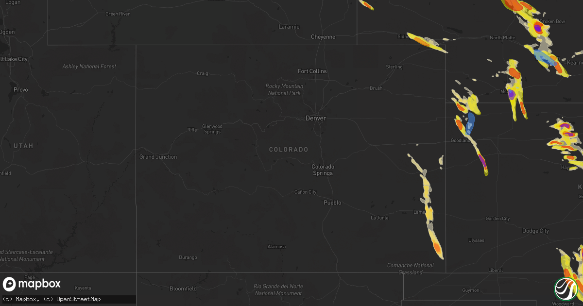
Hail Map in Colorado on June 5, 2022
Get this storm
June 5 map
$229
one time, instant access
Download today. No call, no setup
Keep the $229
Bought the map and want the full workflow? Apply the entire $229 to a subscription within 7 days. None of it is wasted.
Every map, not just this one
This buys you this map. Subscription and you get every map we run, in the markets you choose from a few cities to whole states to nationwide. Plus real-time alerts the moment a storm fires.
Contact data
Name, contact info, occupancy, even credit band for addresses in the footprint. You go from where it hit to who to call.
Become the source they trust
Unlimited branding weather history reports on demand. You already have the documented answer ready for the property owner, and you are the one who showed up with it.
Property data and RoofTrace estimates
Pull up any address you have got, its value and the exact code rules for that jurisdiction, straight from One Click Code. Then RoofTrace estimates the squares, pitch, and roof value, priced the way you price.
Storm reports in Colorado
Colorado
| Date | Description |
|---|---|
| 06/05/20226:40 PM CDT | Hailstones measured in picture... Likely after some melting. |
| 06/05/20226:35 PM CDT | A local report indicates 1.00 inch wind near 1 NE BRANDON |
| 06/05/20226:17 PM CDT | A local report indicates 63 MPH wind near 4 WSW LAMAR |
| 06/05/20226:15 PM CDT | Report from mping: ping pong ball |
| 06/05/20226:13 PM CDT | Picture of measurement of multiple hailstones confirmed on social media. |
| 06/05/20225:47 PM CDT | Public reported quarter-size hail with severe storm that moved through the area. |
| 06/05/20225:21 PM CDT | Corrects time of previous hail report from 1 ne brandon. |
| 06/05/20224:56 PM CDT | Most stones around 1 inch with no rain attm. |
| 06/05/20224:36 PM CDT | Trained spotter reported quarter sized hail. |
| 06/05/20226:20 AM CDT | At 1119 PM MDT, a severe thunderstorm was located near Lodgepole, or 12 miles west of Chappell, moving southeast at 35 mph. HAZARD...60 mph wind gusts and quarter size hail. SOURCE...Radar indicated. IMPACT...Hail damage to vehicles is expected. Expect wind damage to roofs, siding, and trees. Locations impacted include... Chappell.This includes Interstate 80 in Nebraska between mile markers 78 and95. |
| 06/05/20226:03 AM CDT | At 1103 PM MDT, a severe thunderstorm was located near Colton, or near Sidney, moving east at 30 mph. HAZARD...60 mph wind gusts and quarter size hail. SOURCE...Radar indicated. IMPACT...Hail damage to vehicles is expected. Expect wind damage to roofs, siding, and trees. Locations impacted include... Lodgepole, Colton and Sunol. This includes Interstate 80 in Nebraska between mile markers 63 and77. |
| 06/05/202212:54 AM CDT | At 553 PM MDT, a severe thunderstorm was located 13 miles northeast of Two Buttes Reservoir, or 24 miles southeast of Lamar, moving south at 40 mph. HAZARD...Golf ball size hail and 70 mph wind gusts. SOURCE...Radar indicated. IMPACT...People and animals outdoors will be injured. Expect hail damage to roofs, siding, windows, and vehicles. Expect considerable tree damage. Wind damage is also likely to mobile homes, roofs, and outbuildings. This severe thunderstorm will be near... Two Buttes around 615 PM MDT. Walsh around 635 PM MDT. Stonington around 650 PM MDT. |
| 06/04/202211:59 PM CDT | At 459 PM MDT, a severe thunderstorm was located 8 miles northeast of Lamar, moving south at 35 mph. HAZARD...Tennis ball size hail and 70 mph wind gusts. SOURCE...Radar indicated. IMPACT...People and animals outdoors will be injured. Expect hail damage to roofs, siding, windows, and vehicles. Expect considerable tree damage. Wind damage is also likely to mobile homes, roofs, and outbuildings. Locations impacted include... Lamar, Granada, Bristol and Two Buttes Reservoir. |
| 06/04/202211:15 PM CDT | At 415 PM MDT, a severe thunderstorm was located over Brandon, or 23 miles south of Cheyenne Wells, moving south at 25 mph. HAZARD...Tennis ball size hail and 60 mph wind gusts. SOURCE...Radar indicated. IMPACT...People and animals outdoors will be injured. Expect hail damage to roofs, siding, windows, and vehicles. Expect wind damage to roofs, siding, and trees. This severe thunderstorm will be near... Bristol around 520 PM MDT. Hartman around 525 PM MDT. Granada and Lamar around 530 PM MDT. Holly around 540 PM MDT. |
| 06/04/202210:52 PM CDT | At 351 PM MDT, a severe thunderstorm was located 12 miles north of Brandon, or 15 miles southwest of Cheyenne Wells, moving southeast at 20 mph. THIS IS A DESTRUCTIVE STORM FOR SHERIDAN LAKE, BRANDON, AND CHIVINGTON. HAZARD...Three inch hail and 60 mph wind gusts. SOURCE...Radar indicated. IMPACT...People and animals outdoors will be severely injured. Expect shattered windows, extensive damage to roofs, siding, and vehicles. Locations impacted include... Brandon, Chivington, and Sheridan Lake. |
| 06/04/202210:41 PM CDT | At 340 PM MDT, a severe thunderstorm was located over Stratton, moving east at 20 mph. HAZARD...Quarter size hail. SOURCE...Trained weather spotters. IMPACT...Damage to vehicles is expected. Locations impacted include... Bethune.This includes Interstate 70 in Colorado between mile markers 416 and433. |
| 06/04/202210:28 PM CDT | At 328 PM MDT, a severe thunderstorm was located 10 miles northeast of Kit Carson, or 15 miles west of Cheyenne Wells, moving southeast at 30 mph. HAZARD...60 mph wind gusts and half dollar size hail. SOURCE...Radar indicated. IMPACT...Hail damage to vehicles is expected. Expect wind damage to roofs, siding, and trees. This severe thunderstorm will remain over mainly rural areas of central Cheyenne County in east central Colorado, including the following locations... Firstview.This includes Highway 385 between mile markers 136 and 142. |
| 06/04/20229:38 PM CDT | Post on twitter with a picture of a heavily damaged windshield. |
| 06/04/20227:59 PM CDT | A local report indicates 1.00 inch wind near 4 SE STONINGTON |
| 06/04/20227:57 PM CDT | A local report indicates 1.50 inch wind near 1 NE WALSH |
| 06/04/20227:45 PM CDT | Corrects previous hail report from walsh. Post on twitter with a picture of a heavily damaged windshield. |
| 06/04/20227:44 PM CDT | A local report indicates 1.75 inch wind near 2 E WALSH |
| 06/04/20227:38 PM CDT | A local report indicates 1.75 inch wind near 3 S TWO BUTTES |
All States Impacted by Hail Map on June 5, 2022
Cities Impacted by Hail Map on June 5, 2022
- Paul, ID
- Rupert, ID
- Burley, ID
- Heyburn, ID
- Bingham, NE
- Rushville, NE
- Guthrie Center, IA
- Newton, KS
- Arlington, KS
- Abbyville, KS
- Evergreen, AL
- Hunter, OK
- Bird City, KS
- Lamont, OK
- Edson, KS
- Oklahoma City, OK
- Lucas, KS
- Ashdown, AR
- Chadron, NE
- Hay Springs, NE
- Oelrichs, SD
- Perry, OK
- Gordon, NE
- Uniontown, WA
- Colton, WA
- Boise, ID
- Payette, ID
- Vale, OR
- Ontario, OR
- Wichita, KS
- Marsland, NE
- Wellington, KS
- Valley Center, KS
- Atkinson, NE
- Amelia, NE
- Great Bend, KS
- Ellinwood, KS
- St John, KS
- Hudson, KS
- Hays, KS
- Halsey, NE
- Bridgeport, NE
- Alliance, NE
- Haworth, OK
- Mountain Home, ID
- Hayes Center, NE
- Burlington, CO
- Arapahoe, CO
- Elgin, OR
- Big Springs, NE
- Waterville, WA
- Winterset, IA
- Elm Creek, NE
- Flagler, CO
- Thedford, NE
- Checotah, OK
- Benton, LA
- Bruneau, ID
- Hammett, ID
- King Hill, ID
- Hagerman, ID
- Jerome, ID
- Wendell, ID
- Buhl, ID
- Batesland, SD
- Heppner, OR
- Lexington, OR
- Waukee, IA
- West Des Moines, IA
- Windsor Heights, IA
- Clive, IA
- Urbandale, IA
- Ranchester, WY
- Parkman, WY
- Dayton, WY
- Mullen, NE
- Blue Springs, NE
- Murphy, ID
- Adrian, OR
- Jordan Valley, OR
- Merriman, NE
- Ellis, KS
- Plainville, KS
- McDonald, KS
- Stratton, NE
- Saint Francis, KS
- Max, NE
- Haigler, NE
- Parks, NE
- Benkelman, NE
- Brule, NE
- Ogallala, NE
- Dawson, IA
- Linden, IA
- Yale, IA
- Anthony, KS
- Konawa, OK
- Plummer, ID
- Lewiston, ID
- Vona, CO
- Priest River, ID
- Haven, KS
- Hutchinson, KS
- Stafford, KS
- Detroit, TX
- Clarksville, TX
- Derby, KS
- Scribner, NE
- Deport, TX
- Talco, TX
- Bogata, TX
- Coleman, OK
- Caddo, OK
- Bristow, OK
- Paris, TX
- Atlanta, KS
- Latham, KS
- Boswell, OK
- Van Meter, IA
- Adel, IA
- Booneville, IA
- Pretty Prairie, KS
- Dickens, NE
- Declo, ID
- Lamar, CO
- Holly, CO
- Two Buttes, CO
- Cheyenne Wells, CO
- Walsh, CO
- Sheridan Lake, CO
- Eads, CO
- Granada, CO
- Kit Carson, CO
- Okanogan, WA
- Bridgeport, WA
- Lenora, KS
- Sawyer, KS
- Kechi, KS
- Yoder, WY
- Torrington, WY
- Kamiah, ID
- Weippe, ID
- Spencer, OK
- Arthur City, TX
- Blossom, TX
- Powderly, TX
- Ellsworth, KS
- Goodland, KS
- Brewster, KS
- Winona, KS
- Colby, KS
- Wauneta, NE
- Phillipsburg, KS
- Champion, NE
- Medford, OK
- Caldwell, KS
- Perkins, OK
- Argonia, KS
- Freeport, KS
- Milan, KS
- Delaware, OK
- Allen, SD
- Caldwell, ID
- Melba, ID
- Nampa, ID
- Kuna, ID
- Longton, KS
- Hope, AR
- Bradley, AR
- Opelousas, LA
- Crescent, OK
- Wilmore, KS
- Moscow, ID
- Genesee, ID
- Lincoln, KS
- Duncombe, IA
- Cumming, IA
- Hemingford, NE
- Walker, KS
- Victoria, KS
- Crawford, NE
- Harrison, NE
- Burchard, NE
- Pawnee City, NE
- Du Bois, NE
- Sylvan Grove, KS
- Riverdale, NE
- Kearney, NE
- Oakesdale, WA
- Thornton, WA
- Juliaetta, ID
- Fairmont, NE
- McCool Junction, NE
- Exeter, NE
- Lyman, NE
- Harrisburg, NE
- Liberty, NE
- Fort Scott, KS
- Redfield, KS
- Gibbon, NE
- Ravenna, NE
- Pleasanton, NE
- Anselmo, NE
- Merna, NE
- Sumner, TX
- Hugo, OK
- Aline, OK
- Okeene, OK
- Sun City, KS
- Dacoma, OK
- Protection, KS
- Alva, OK
- Haviland, KS
- Waynoka, OK
- Cleo Springs, OK
- Freedom, OK
- Fairview, OK
- Coldwater, KS
- Chester, OK
- Medicine Lodge, KS
- Mooreland, OK
- Mullinville, KS
- Hardtner, KS
- Isabella, OK
- Carmen, OK
- Lake City, KS
- Maxwell, NE
- Bartley, NE
- Norcatur, KS
- Wellfleet, NE
- Moorefield, NE
- Indianola, NE
- Maywood, NE
- Danbury, NE
- Stockville, NE
- McCook, NE
- Curtis, NE
- Oberlin, KS
- Garden Plain, KS
- Humboldt, KS
- Georgiana, AL
- Forest Home, AL
- Chanute, KS
- Buffalo, KS
- Yates Center, KS
- Benedict, KS
- De Kalb, TX
- Lahoma, OK
- Meno, OK
- Enid, OK
- Carrier, OK
- Kremlin, OK
- Ringwood, OK
- Goltry, OK
- Helena, OK
- Valentine, NE
- Hughes Springs, TX
- Naples, TX
- Wapanucka, OK
- Oconto, NE
- Callaway, NE
- Sedgwick, KS
- Laurel Hill, FL
- Florala, AL
- Lake Creek, TX
- Cooper, TX
- Opp, AL
- Malta, ID
- Plaquemine, LA
- Winter Haven, FL
- Overton, NE
- Loomis, NE
- Bertrand, NE
- Baxley, GA
- Surrency, GA
- Cody, NE
- Whitman, NE
- Palco, KS
- Damar, KS
- Bogue, KS
- Stockton, KS
- Cozad, NE
- Chappell, NE
- Sidney, NE
- Lodgepole, NE
- Mount Hope, KS
- Burrton, KS
- Saint Martinville, LA
- Halstead, KS
- McDavid, FL
- Bentley, KS
- Colwich, KS
- Maize, KS
- Plain Dealing, LA
- Coats, KS
- Yukon, OK
- Edmond, OK
- Jones, OK
- Arcadia, OK
- Guthrie, OK
- Piedmont, OK
- Waukomis, OK
- Maramec, OK
- Jennings, OK
- Foreman, AR
- Spiro, OK
- Dike, TX
- Sulphur Springs, TX
- Westwego, LA
- New Orleans, LA
- Kenner, LA
- Saint Rose, LA
- Metairie, LA
- Ama, LA
- Carrabelle, FL
- Eddyville, NE
- Arnold, NE
- Stapleton, NE
- Broken Bow, NE
- Gothenburg, NE
- Shreveport, LA
- Bossier City, LA
- Barksdale Afb, LA
- Arkansas City, KS
- Newkirk, OK
- Stratford, OK
- Enterprise, AL
- Coalgate, OK
- Douglas, OK
- Eufaula, OK
- Lenapah, OK
- Geuda Springs, KS
- Pond Creek, OK
- Holt, FL
- Marshall, OK
- Stillwater, OK
- Orlando, OK
- Mulhall, OK
- Cashion, OK
- Bagwell, TX
- Carencro, LA
- Ariton, AL
- Burlington, OK
- Natoma, KS
- Prattville, AL
- Vernon, FL
- Glade, KS
- Clearwater, KS
- Haysville, KS
- Dorrance, KS
- Wilson, KS
- Luray, KS
- Paradise, KS
- Russell, KS
- Waldo, KS
- Bunker Hill, KS
- Stonewall, OK
- Milburn, OK
- Kirwin, KS
- Logan, KS
- Braman, OK
- Wellston, OK
- Kingman, KS
- Wakita, OK
- Kaw City, OK
- Shidler, OK
- Coyle, OK
- Missouri Valley, IA
- Honey Creek, IA
- Gorham, KS
- Catharine, KS
- Eustis, NE
- Smithfield, NE
- Elwood, NE
- Willow Island, NE
- Seneca, NE
- Holdrege, NE
- Funk, NE
- Lexington, NE
- Fort Towson, OK
- Eclectic, AL
- Moundridge, KS
- Buhler, KS
- Inman, KS
- Windom, KS
- Little River, KS
- Mcpherson, KS
- Bokchito, OK
- Bennington, OK
- Nash, OK
- Manchester, OK
- Lewisville, AR
- Breaux Bridge, LA
- Creston, IA
- Hoisington, KS
- Prairie View, KS
- Woodston, KS
- Claflin, KS
- Holyrood, KS
- Alton, KS
- Tonkawa, OK
- Douglassville, TX
- Stigler, OK
- Bison, OK
- Julesburg, CO
- Ovid, CO
- Sedgwick, CO
- Elk Falls, KS
- Billings, OK
- Garber, OK
- Ada, OK
- Wanette, OK
- Tupelo, OK
- Centrahoma, OK
- Tecumseh, OK
- Fitzhugh, OK
- Noble, OK
- Norman, OK
- Shawnee, OK
- Fittstown, OK
- Lexington, OK
- Byars, OK
- Roff, OK
- Newalla, OK
- Mcloud, OK
- Atoka, OK
- Macomb, OK
- Asher, OK
- Allen, OK
- Nowata, OK
- Wetumpka, AL
- Kiowa, KS
- Hazelton, KS
- Goddard, KS
- Viola, KS
- Terlton, OK
- Cleveland, OK
- Pattonville, TX
- Waldron, AR
- Hennessey, OK
- Dover, OK
- Andale, KS
- Nickerson, KS
- Lafayette, LA
- Broussard, LA
- Blackwell, OK
- Lorraine, KS
- Geneseo, KS
- Castleberry, AL
- Ames, OK
- Bluff City, KS
- Robertsdale, AL
- Seminole, AL
- Ashton, ID
- Fort Calhoun, NE
- Crescent, IA
- Persia, IA
- Logan, IA
- Omaha, NE
- Norco, LA
- Hahnville, LA
- Destrehan, LA
- Dozier, AL
- Gantt, AL
- Boone, IA
- Madrid, IA
- Woodward, IA
- Lyons, KS
- Mannford, OK
- Sparks, OK
- Chandler, OK
- Stroud, OK
- Edgard, LA
- Reserve, LA
- Mount Airy, LA
- Garyville, LA
- Thibodaux, LA
- Meridian, OK
- Luther, OK
- Lowndesboro, AL
- Montgomery, AL
- Okemah, OK
- Boley, OK
- Castle, OK
- Fulton, AR
- Ogden, AR
- Harper, KS
- Wilder, ID
- Homedale, ID
- Glenns Ferry, ID
- Garden City, ID
- Eagle, ID
- Star, ID
- Venango, NE
- Meridian, ID
- Tensed, ID
- Farmington, WA
- Culdesac, ID
- Lapwai, ID
- Red Rock, OK
- Glencoe, OK
- Morrison, OK
- Skiatook, OK
- Osage, OK
- Owasso, OK
- Tulsa, OK
- Hominy, OK
- Pawnee, OK
- Ralston, OK
- Ponca City, OK
- Fairfax, OK
- Sperry, OK
- Prue, OK
- Sand Springs, OK
- Marland, OK
- Collinsville, OK
- Barnsdall, OK
- Wynona, OK
- Drummond, OK
- Stratton, CO
- Tryon, NE
- Lebanon, NE
- Jennings, KS
- Clarkston, WA
- East Wenatchee, WA


