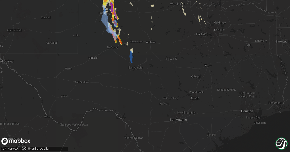
Hail Map in Texas on June 4, 2020
Get this storm
June 4 map
$229
one time, instant access
Download today. No call, no setup
Keep the $229
Bought the map and want the full workflow? Apply the entire $229 to a subscription within 7 days. None of it is wasted.
Every map, not just this one
This buys you this map. Subscription and you get every map we run, in the markets you choose from a few cities to whole states to nationwide. Plus real-time alerts the moment a storm fires.
Contact data
Name, contact info, occupancy, even credit band for addresses in the footprint. You go from where it hit to who to call.
Become the source they trust
Unlimited branding weather history reports on demand. You already have the documented answer ready for the property owner, and you are the one who showed up with it.
Property data and RoofTrace estimates
Pull up any address you have got, its value and the exact code rules for that jurisdiction, straight from One Click Code. Then RoofTrace estimates the squares, pitch, and roof value, priced the way you price.
Storm reports in Texas
Texas
| Date | Description |
|---|---|
| 06/04/20206:50 PM CDT | A local report indicates 1.75 inch wind near 8 W FLOYDADA |
| 06/04/20206:42 PM CDT | A local report indicates 1.00 inch wind near 1 SW BRISCOE |
| 06/04/20206:38 PM CDT | A local report indicates 58 MPH wind near 2 W CHILDRESS |
| 06/04/20205:32 PM CDT | Quarter size hail lasted a few minutes. |
| 06/04/20205:24 PM CDT | A local report indicates 60 MPH wind near CAPROCK CANYON SP |
| 06/04/20205:10 PM CDT | Winds gust of 72 mph at silverton mesonet. |
| 06/04/20205:07 PM CDT | Mostly pea to dime size hail with a few as large as quarters. |
| 06/04/20204:45 PM CDT | Mostly pea to dime size hail with a few up to the size of quarters. Hail lasted about 10 minutes. |
| 06/04/20204:15 PM CDT | Quarter size hail lasted a few minutes. |
| 06/04/20203:17 PM CDT | Dime to quarter size hail falling at time of observation. |
| 06/04/20203:11 PM CDT | Mostly dime to nickel size hail with a few quarter size stones. Lasted about 5 minutes. |
| 06/04/202011:15 AM CDT | Home roof damage |
| 06/04/20206:58 AM CDT | At 1157 PM CDT, a severe thunderstorm was located near Coahoma, or 12 miles northeast of Big Spring, moving southeast at 30 mph. HAZARD...70 mph wind gusts and quarter size hail. SOURCE...Radar indicated. IMPACT...Hail damage to vehicles is expected. Expect considerable tree damage. Wind damage is also likely to mobile homes, roofs, and outbuildings. Locations impacted include... Coahoma, Sand Springs and Westbrook. This includes Interstate 20 between mile markers 185 and 209. |
| 06/04/20206:31 AM CDT | At 1130 PM CDT, a severe thunderstorm was located 1 miles east of Gail, moving south at 25 mph. HAZARD...70 mph wind gusts and quarter size hail. SOURCE...Radar indicated. IMPACT...Hail damage to vehicles is expected. Expect considerable tree damage. Wind damage is also likely to mobile homes, roofs, and outbuildings. Locations impacted include... Snyder, Gail and Fluvanna. |
| 06/04/20206:20 AM CDT | At 1119 PM CDT, a severe thunderstorm was located near Gail, moving south at 25 mph. This is a very dangerous storm. HAZARD...85 mph wind gusts and half dollar size hail. SOURCE...Radar indicated. IMPACT...Flying debris will be dangerous to those caught without shelter. Mobile homes will be heavily damaged. Expect considerable damage to roofs, windows, and vehicles. Extensive tree damage and power outages are likely. Locations impacted include... Snyder, Lamesa, Colorado City, Ackerly, Loraine, Colorado City Airport, J B Thomas Reservoir, Inadale, Luther, Los Ybanez, Sparenberg, Vincent, Hermleigh, Randalls Corner, Winston Field, Knapp, Cuthbert, Buford, Dunn and Tenmile. |
| 06/04/20205:30 AM CDT | At 1028 PM CDT, a severe thunderstorm was located near Post, moving south at 35 mph. A second severe storm was located 17 miles north of Mesquite. HAZARD...Golf ball size hail and 70 mph wind gusts. SOURCE...Radar indicated. IMPACT...People and animals outdoors will be injured. Expect hail damage to roofs, siding, windows, and vehicles. Expect considerable tree damage. Wind damage is also likely to mobile homes, roofs, and outbuildings. Locations impacted include... Lamesa, Gail, Fluvanna, Lamesa Municipal Airport, Los Ybanez, Randalls Corner, Arvana, Hancock and Key. |
| 06/04/20205:24 AM CDT | At 1024 PM CDT, severe thunderstorms were located along a line extending from 12 miles east of Post to 6 miles east of Grassland to near Tahoka, moving south at 35 mph. HAZARD...70 mph wind gusts and quarter size hail. SOURCE...Radar indicated. IMPACT...Hail damage to vehicles is expected. Expect considerable tree damage. Wind damage is also likely to mobile homes, roofs, and outbuildings. Locations impacted include... Post, Tahoka, Lake Alan Henry, O'donnell, Grassland, Southland, Justiceburg, Wilson and New Home. |
| 06/04/20205:06 AM CDT | At 1005 PM CDT, severe thunderstorms were located along a line extending from near Grady to near Archer City, moving southeast at 40 mph. HAZARD...60 mph wind gusts. SOURCE...Trained weather spotters. IMPACT...Expect damage to roofs, siding, and trees. Locations impacted include... Bowie, Jacksboro, Nocona, Alvord, Chico, Bryson, Sunset, Stoneburg, Forestburg and Newport. |
| 06/04/20205:02 AM CDT | At 1001 PM CDT, the leading edge of winds from a line of severe thunderstorms was located along a line extending from 5 miles southwest of Terral to 4 miles east of Lake Kickapoo, moving south at 35 mph. HAZARD...70 mph wind gusts. SOURCE...Radar indicated. IMPACT...Expect considerable tree damage. Damage is likely to mobile homes, roofs, and outbuildings. Locations impacted include... Henrietta, Archer City, Scotland, Windthorst, Bellevue, Newport, Lake Arrowhead, Lake Kickapoo, Bluegrove, Joy, Vashti and Shannon. |
| 06/04/20204:58 AM CDT | At 958 PM CDT, a severe thunderstorm was located 4 miles northeast of Tahoka, moving south at 40 mph. HAZARD...70 mph wind gusts. SOURCE...Radar indicated. IMPACT...Expect considerable tree damage. Damage is likely to mobile homes, roofs, and outbuildings. Locations impacted include... Post, Tahoka, Lake Alan Henry, O'donnell, Grassland, Southland, Justiceburg and Wilson. |
| 06/04/20204:43 AM CDT | At 943 PM CDT, severe thunderstorms were located along a line extending from 9 miles south of Slide to 6 miles north of Locketville, moving south at 25 mph. These are very dangerous storms. HAZARD...80 mph wind gusts. SOURCE...Radar indicated. IMPACT...Flying debris will be dangerous to those caught without shelter. Mobile homes will be heavily damaged. Expect considerable damage to roofs, windows, and vehicles. Extensive tree damage and power outages are likely. Locations impacted include... Brownfield, O'donnell, Locketville, New Moore, Meadow, Ropesville and New Home. |
| 06/04/20204:23 AM CDT | At 923 PM CDT, severe thunderstorms were located along a line extending from 5 miles south of Floydada to 6 miles northwest of Lorenzo to 3 miles southeast of Shallowater, moving southeast at 45 mph. These are very dangerous storms. HAZARD...80 mph wind gusts and quarter size hail. SOURCE...Radar indicated. IMPACT...Flying debris will be dangerous to those caught without shelter. Mobile homes will be heavily damaged. Expect considerable damage to roofs, windows, and vehicles. Extensive tree damage and power outages are likely. Locations impacted include... Lubbock, Slaton, Post, Floydada, Crosbyton, Spur, White River Lake, Wolfforth, Idalou, Ralls, Lorenzo, Ransom Canyon, Kalgary, Lubbock South Plains Mall, Slide, Woodrow, Reese Center, Cone, Caprock and Southland. |
| 06/04/20204:18 AM CDT | At 917 PM CDT, a severe thunderstorm was located near Avoca, or 9 miles southeast of Stamford, moving southeast at 40 mph. HAZARD...60 mph wind gusts. SOURCE...Radar indicated. IMPACT...Expect damage to roofs, siding, and trees. This severe thunderstorm will be near... Lueders around 925 PM CDT.Other locations impacted by this severe thunderstorm include BigCountry Baptist Assembly, The Intersection Of Us-180 And Farm Road 600 and Mccarty Lake. |
| 06/04/20204:00 AM CDT | At 900 PM CDT, a severe thunderstorm was located near Lorenzo, or 13 miles west of Crosbyton, moving south at 20 mph. HAZARD...Golf ball size hail and 60 mph wind gusts. SOURCE...Radar indicated. IMPACT...People and animals outdoors will be injured. Expect hail damage to roofs, siding, windows, and vehicles. Expect wind damage to roofs, siding, and trees. Locations impacted include... Ralls, Lorenzo and Cone. |
| 06/04/20203:55 AM CDT | At 854 PM CDT, severe thunderstorms were located along a line extending from 7 miles southeast of Plainview to 12 miles northeast of Abernathy to 5 miles south of Hale Center, moving southeast at 30 mph. HAZARD...60 mph wind gusts and quarter size hail. SOURCE...Radar indicated. IMPACT...Hail damage to vehicles is expected. Expect wind damage to roofs, siding, and trees. Locations impacted include... Plainview, Abernathy, Petersburg, Cotton Center and New Deal. |
| 06/04/20203:44 AM CDT | At 843 PM CDT, severe thunderstorms were located along a line extending from 8 miles north of Fargo to near Cache, moving southeast at 35 mph. HAZARD...70 mph wind gusts and quarter size hail. SOURCE...Radar indicated. A 65 mph wind gust was measured in Tipton. This line of storms has a history of producing damaging winds. IMPACT...Hail damage to vehicles is expected. Expect considerable tree damage. Wind damage is also likely to mobile homes, roofs, and outbuildings. Locations impacted include... Burkburnett, Frederick, Walters, Cache, Electra, Grandfield, Temple, Tipton, Chattanooga, Randlett, Indiahoma, Davidson, Manitou, Devol, Faxon, Hollister, Loveland, Cookietown, southwestern Fort Sill and Taylor. |
| 06/04/20203:42 AM CDT | At 841 PM CDT, a severe thunderstorm was located near Haskell, moving southeast at 40 mph. HAZARD...60 mph wind gusts and penny size hail. SOURCE...Radar indicated. IMPACT...Expect damage to roofs, siding, and trees. This severe thunderstorm will be near... Haskell around 845 PM CDT. Paint Creek and Irby around 855 PM CDT. Stamford and Lake Stamford Marina around 900 PM CDT.Other locations impacted by this severe thunderstorm include TheIntersection Of Us-283 And Ranch Road 209. |
| 06/04/20203:26 AM CDT | At 825 PM CDT, a severe thunderstorm was located 6 miles east of Petersburg, or 11 miles southwest of Floydada, moving southeast at 15 mph. HAZARD...60 mph wind gusts and quarter size hail. SOURCE...Radar indicated. IMPACT...Hail damage to vehicles is expected. Expect wind damage to roofs, siding, and trees. Locations impacted include... Ralls, Petersburg and Cone. |
| 06/04/20203:23 AM CDT | At 823 PM CDT, a severe thunderstorm was located over Halfway, or 9 miles northwest of Hale Center, moving southeast at 25 mph. HAZARD...60 mph wind gusts and quarter size hail. SOURCE...Radar indicated. IMPACT...Hail damage to vehicles is expected. Expect wind damage to roofs, siding, and trees. Locations impacted include... Plainview, Hale Center, Olton, Halfway and Seth Ward. |
| 06/04/20203:17 AM CDT | At 816 PM CDT, a severe thunderstorm was located 6 miles southeast of Caprock, or 13 miles west of White River Lake, moving southeast at 30 mph. HAZARD...Two inch hail and 70 mph wind gusts. SOURCE...Radar indicated. IMPACT...People and animals outdoors will be injured. Expect hail damage to roofs, siding, windows, and vehicles. Expect considerable tree damage. Wind damage is also likely to mobile homes, roofs, and outbuildings. Locations impacted include... Post, Kalgary and Caprock. |
| 06/04/20202:32 AM CDT | At 732 PM CDT, a severe thunderstorm was located 5 miles northeast of Gilliland, moving southeast at 15 mph. HAZARD...60 mph wind gusts and quarter size hail. SOURCE...Radar indicated. IMPACT...Hail damage to vehicles is expected. Expect wind damage to roofs, siding, and trees. Locations impacted include... Gilliland. |
| 06/04/20202:32 AM CDT | At 731 PM CDT, a severe thunderstorm was located 9 miles southwest of Aiken, or 11 miles southeast of Plainview, moving east at 15 mph. HAZARD...60 mph wind gusts and quarter size hail. SOURCE...Radar indicated. IMPACT...Hail damage to vehicles is expected. Expect wind damage to roofs, siding, and trees. Locations impacted include... Floydada and Lockney. |
| 06/04/20202:28 AM CDT | At 726 PM CDT, a severe thunderstorm was located over Ralls, or 11 miles west of Crosbyton, moving southeast at 30 mph. HAZARD...Golf ball size hail and 70 mph wind gusts. Large amounts of smaller hail should also be expected in the path of this storm. Intense rain combined with small hail may lead to minor flooding as well. SOURCE...Radar indicated. IMPACT...People and animals outdoors will be injured. Expect hail damage to roofs, siding, windows, and vehicles. Expect considerable tree damage. Wind damage is also likely to mobile homes, roofs, and outbuildings. Locations impacted include... Crosbyton, Ralls, Lorenzo, Kalgary and Caprock. |
| 06/04/20201:41 AM CDT | At 640 PM CDT, a severe thunderstorm was located 7 miles northeast of Petersburg, or 10 miles west of Floydada, moving southeast at 25 mph. HAZARD...Ping pong ball size hail and 60 mph wind gusts. Large amounts of small hail should also be expected with this storm. SOURCE...Radar indicated. IMPACT...People and animals outdoors will be injured. Expect hail damage to roofs, siding, windows, and vehicles. Expect wind damage to roofs, siding, and trees. Locations impacted include... Ralls, Petersburg, Lorenzo and Cone. |
| 06/04/20201:00 AM CDT | At 600 PM CDT, a severe thunderstorm was located near Aiken, or 8 miles southeast of Plainview, moving southeast at 20 mph. HAZARD...60 mph wind gusts and quarter size hail. SOURCE...Radar indicated. IMPACT...Hail damage to vehicles is expected. Expect wind damage to roofs, siding, and trees. Locations impacted include... Lockney and Aiken. |
| 06/04/202012:26 AM CDT | At 525 PM CDT, a severe thunderstorm was located 4 miles west of Quitaque, or 6 miles southwest of Caprock Canyon State Park, moving southeast at 25 mph. HAZARD...70 mph wind gusts and quarter size hail. Large amounts of small hail are also possible with this storm. SOURCE...Radar indicated. IMPACT...Hail damage to vehicles is expected. Expect considerable tree damage. Wind damage is also likely to mobile homes, roofs, and outbuildings. Locations impacted include... Caprock Canyon State Park, Quitaque, Flomot and Valley Schools. |
| 06/04/202012:09 AM CDT | At 508 PM CDT, a severe thunderstorm was located 4 miles north of Plainview, moving southeast at 25 mph. HAZARD...Ping pong ball size hail and 60 mph wind gusts. SOURCE...Radar indicated. IMPACT...People and animals outdoors will be injured. Expect hail damage to roofs, siding, windows, and vehicles. Expect wind damage to roofs, siding, and trees. Locations impacted include... Plainview, Lockney, Kress, Aiken and Seth Ward. |
| 06/03/202011:50 PM CDT | At 449 PM CDT, a severe thunderstorm was located 14 miles northeast of Silverton, moving east at 30 mph. HAZARD...60 mph wind gusts and quarter size hail. SOURCE...Radar indicated. IMPACT...Hail damage to vehicles is expected. Expect wind damage to roofs, siding, and trees. Locations impacted include... Memphis, Silverton, Turkey, Caprock Canyon State Park, Valley Schools, Brice, Lakeview and Plaska Community. |
| 06/03/202011:30 PM CDT | At 430 PM CDT, a severe thunderstorm was located 7 miles southwest of Tulia, moving east at 20 mph. HAZARD...Ping pong ball size hail and 60 mph wind gusts. SOURCE...Radar indicated. IMPACT...People and animals outdoors will be injured. Expect hail damage to roofs, siding, windows, and vehicles. Expect wind damage to roofs, siding, and trees. Locations impacted include... Tulia, Kress, Mackenzie Reservoir and Claytonville. |
| 06/03/202011:15 PM CDT | A local report indicates 83 MPH wind near 2 ESE GAIL |
| 06/03/202011:10 PM CDT | A local report indicates 1.75 inch wind near GAIL |
| 06/03/202011:06 PM CDT | A local report indicates 60 MPH wind near GAIL |
| 06/03/202010:44 PM CDT | At 343 PM CDT, a severe thunderstorm was located 12 miles southwest of Happy, or 15 miles west of Tulia, moving east at 20 mph. HAZARD...Ping pong ball size hail and 60 mph wind gusts. SOURCE...Radar indicated. IMPACT...People and animals outdoors will be injured. Expect hail damage to roofs, siding, windows, and vehicles. Expect wind damage to roofs, siding, and trees. Locations impacted include... Tulia, Kress, Happy and Nazareth. |
| 06/03/202010:40 PM CDT | Measured by the west texas mesonet |
| 06/03/202010:35 PM CDT | A local report indicates 85 MPH wind near 5 SSW GRAHAM |
| 06/03/202010:32 PM CDT | Metal carport blown into street near nocona high school. Damage reported by nocona pd. |
| 06/03/202010:30 PM CDT | A local report indicates 73 MPH wind near 5 SSW GRAHAM |
| 06/03/202010:23 PM CDT | At 323 PM CDT, a severe thunderstorm was located over Palo Duro Canyon, or 12 miles east of Canyon, moving east at 25 mph. HAZARD...60 mph wind gusts and quarter size hail. SOURCE...Radar indicated. IMPACT...Minor damage to roofs, siding, and trees is possible. Hail damage to vehicles is expected. Locations impacted include... Clarendon, Claude, Howardwick, Wayside, Washburn, Greenbelt Lake, Goodnight and Palo Duro Canyon. |
| 06/03/202010:20 PM CDT | A local report indicates 73 MPH wind near 1 NE POST |
| 06/03/202010:18 PM CDT | At 318 PM CDT, a severe thunderstorm was located 6 miles west of Panhandle, moving east at 20 mph. HAZARD...60 mph wind gusts and quarter size hail. SOURCE...Radar indicated. IMPACT...Minor damage to roofs, siding, and trees is possible. Hail damage to vehicles is expected. Locations impacted include... Pampa, Panhandle, White Deer, Groom, Kingsmill, Washburn and Pantex. |
| 06/03/202010:15 PM CDT | Numerous reports of wind damage in post... Including outbuilding flattened... Carports lofted... Roofs damaged and a semi flipped. Time of damage estimated from radar a |
| 06/03/202010:10 PM CDT | A local report indicates 67 MPH wind near 1 NE POST |
| 06/03/202010:06 PM CDT | At 306 PM CDT, a severe thunderstorm was located 12 miles northeast of Dimmitt, moving east at 20 mph. HAZARD...Ping pong ball size hail and 60 mph wind gusts. SOURCE...Radar indicated. IMPACT...People and animals outdoors will be injured. Expect hail damage to roofs, siding, windows, and vehicles. Expect wind damage to roofs, siding, and trees. Locations impacted include... Happy and Nazareth. |
| 06/03/202010:04 PM CDT | A local report indicates 60 MPH wind near 3 NNE TAHOKA |
| 06/03/202010:00 PM CDT | Transmission poles down. Time estimated from radar and nearby observations. |
| 06/03/20209:50 PM CDT | Measured 1 mi s of archer wichita county line on hwy 281. |
| 06/03/20209:50 PM CDT | 3 transmission poles down. Time of damage estimated from radar and nearby observations. |
| 06/03/20209:45 PM CDT | A local report indicates 70 MPH wind near S WICHITA FALLS |
| 06/03/20209:40 PM CDT | A local report indicates 60 MPH wind near 2 NE SLATON |
| 06/03/20209:38 PM CDT | A local report indicates 60 MPH wind near 3 NW WOODROW |
| 06/03/20209:35 PM CDT | A local report indicates 68 MPH wind near SHEPPARD AFB |
| 06/03/20209:30 PM CDT | A local report indicates 72 MPH wind near 3 WNW LUBBOCK |
| 06/03/20209:28 PM CDT | A local report indicates 63 MPH wind near 2 SE BURKBURNETT |
| 06/03/20209:27 PM CDT | A local report indicates 69 MPH wind near REESE CENTER |
| 06/03/20209:20 PM CDT | A local report indicates 77 MPH wind near 6 NNE LUBBOCK |
| 06/03/20208:35 PM CDT | Roof damaged |
| 06/03/20207:56 PM CDT | A local report indicates 67 MPH wind near 1 E CROWELL |
| 06/03/20207:45 PM CDT | Time from radar |
| 06/03/20207:35 PM CDT | A local report indicates 62 MPH wind near 1 SE RALLS |
| 06/03/20207:30 PM CDT | Center pivot flipped near ralls. Location and time estimated. |
| 06/03/20207:28 PM CDT | A local report indicates 2.00 inch wind near 1 NNE ALLMON |
| 06/03/20207:00 PM CDT | A local report indicates 1.75 inch wind near 7 N LORENZO |
All States Impacted by Hail Map on June 4, 2020
Cities Impacted by Hail Map on June 4, 2020
- Lincoln, NE
- Smith Center, KS
- Lebanon, KS
- Red Cloud, NE
- Riverton, NE
- Burr Oak, KS
- Inavale, NE
- Laverne, OK
- Claude, TX
- Duncan, OK
- Milford, IA
- Spearfish, SD
- Utica, NE
- Waco, NE
- Benedict, NE
- York, NE
- Gresham, NE
- Steamboat Rock, IA
- Silverton, TX
- Harrisonville, PA
- Gail, TX
- Fluvanna, TX
- Bladen, NE
- Ulysses, KS
- Ida Grove, IA
- Memphis, TN
- Germantown, TN
- Maryneal, TX
- Mechanicsville, IA
- Tipton, IA
- Hart, TX
- Hale Center, TX
- Olton, TX
- Plainview, TX
- Saint Onge, SD
- Whitewood, SD
- Belle Fourche, SD
- Beulah, WY
- Aladdin, WY
- Saint George, KS
- Danville, WV
- Seth, WV
- Madison, WV
- Peytona, WV
- Turtle Creek, WV
- Foster, WV
- Lubbock, TX
- Decatur, TX
- Hebron, NE
- Needmore, PA
- McConnellsburg, PA
- Fort Loudon, PA
- Mercersburg, PA
- Humboldt, IA
- Milesville, SD
- Midland, SD
- Gillette, WY
- Hendricks, MN
- Waverly, IA
- Sumner, IA
- Tripoli, IA
- Vesuvius, VA
- Raphine, VA
- Robert Lee, TX
- Stratford, IA
- Rozet, WY
- Pleasant Dale, NE
- Milford, NE
- Terril, IA
- La Porte City, IA
- Bremen, KS
- Marysville, KS
- Clifton, KS
- Palmer, KS
- Linn, KS
- Clay Center, KS
- Cordova, TN
- Liberal, KS
- Hugoton, KS
- Martin, SD
- Allen, SD
- Tuthill, SD
- Wellfleet, NE
- Warsaw, OH
- Blissfield, OH
- Walhonding, OH
- Canadian, TX
- Ruthton, MN
- Salem, NE
- Morrill, KS
- Hiawatha, KS
- Sabetha, KS
- Clarendon, TX
- Mobeetie, TX
- Miami, TX
- Hill City, SD
- Deadwood, SD
- Rapid City, SD
- Lead, SD
- Masonville, IA
- Lamont, IA
- Winthrop, IA
- Ellsworth Afb, SD
- Devils Tower, WY
- Scenic, SD
- Sturgis, SD
- Nemo, SD
- New Underwood, SD
- Piedmont, SD
- Sundance, WY
- Hermosa, SD
- Moorcroft, WY
- Wasta, SD
- Caputa, SD
- Box Elder, SD
- Black Hawk, SD
- Wanblee, SD
- Kyle, SD
- Gilmore City, IA
- Tulia, TX
- Cimarron, KS
- Dupree, SD
- Faith, SD
- Comstock, NE
- Haddam, KS
- Morrowville, KS
- Grantville, PA
- Palmyra, PA
- Annville, PA
- Harrisburg, PA
- Ratliff City, OK
- Graham, OK
- Lakefield, MN
- Windom, MN
- Bethel, PA
- Myerstown, PA
- Hulett, WY
- Lorenzo, TX
- Floydada, TX
- Ralls, TX
- Post, TX
- Reva, SD
- Prairie City, SD
- Grundy Center, IA
- Buckingham, IA
- Reinbeck, IA
- Traer, IA
- Lincoln, IA
- Morrison, IA
- Gladbrook, IA
- Wichita Falls, TX
- Alzada, MT
- Broadus, MT
- Fulda, MN
- Worthington, MN
- Brewster, MN
- Limestone, TN
- Chuckey, TN
- West Jefferson, OH
- London, OH
- Mount Sterling, OH
- Orient, OH
- Erick, OK
- Millersburg, PA
- Millerstown, PA
- Liverpool, PA
- Newport, PA
- Halifax, PA
- Duncannon, PA
- Dauphin, PA
- Seward, NE
- Clearville, PA
- Everett, PA
- Olsburg, KS
- Amanda, OH
- Lancaster, OH
- Circleville, OH
- Ashville, OH
- Stoutsville, OH
- York, PA
- Seven Valleys, PA
- Spring Grove, PA
- York New Salem, PA
- Dallastown, PA
- Luray, KS
- Fargo, OK
- Gage, OK
- Shattuck, OK
- Pocahontas, IA
- Cuba, KS
- Agenda, KS
- Saint Francis, SD
- Perryton, TX
- Kress, TX
- Heron Lake, MN
- Battle Creek, IA
- Philipsburg, PA
- Del Rio, TN
- Everest, KS
- Sargent, NE
- Broken Bow, NE
- Anselmo, NE
- Dike, IA
- Parkersburg, IA
- Valentine, NE
- Hardesty, OK
- Iowa Falls, IA
- Alden, IA
- Glasgow, VA
- Buena Vista, VA
- Natural Bridge, VA
- Natural Bridge Station, VA
- Buchanan, VA
- Montvale, VA
- Russell, MN
- Balaton, MN
- Tyler, MN
- Sayre, OK
- Temple, OK
- Waurika, OK
- Walters, OK
- Hastings, OK
- Alva, WY
- Quitaque, TX
- Lehigh, IA
- Webster City, IA
- Stanhope, IA
- Duncombe, IA
- Milford Center, OH
- Marysville, OH
- Edgemont, SD
- Wadena, IA
- Arlington, IA
- Elkader, IA
- Fayette, IA
- Strawberry Point, IA
- Volga, IA
- Loveland, OK
- Balko, OK
- Big Spring, TX
- Coahoma, TX
- Tahoka, TX
- Odonnell, TX
- Guide Rock, NE
- Superior, NE
- Hudson, IA
- Waterloo, IA
- Hartley, IA
- Melvin, IA
- Cherry Creek, SD
- Jetmore, KS
- Ingalls, KS
- Frankfort, KS
- Matador, TX
- Garvin, MN
- Jewell, KS
- Beloit, KS
- Randall, KS
- Follett, TX
- Booker, TX
- Deshler, NE
- Big Prairie, OH
- Glenmont, OH
- Killbuck, OH
- Norton, KS
- Nelson, NE
- Ruskin, NE
- Hardy, NE
- Moscow, KS
- Wheeler, TX
- Briscoe, TX
- Concordia, KS
- Scandia, KS
- Belleville, KS
- Manhattan, KS
- May, OK
- Tarkio, MO
- Letart, WV
- Aurelia, IA
- Exeter, NE
- Fairmont, NE
- McCool Junction, NE
- Mission, SD
- Hawkeye, IA
- Lebanon, MO
- Fonda, IA
- Henrietta, TX
- Atalissa, IA
- West Liberty, IA
- Waterloo, NE
- Ashland, NE
- Elkhorn, NE
- Gretna, NE
- Nocona, TX
- Osco, IL
- Cambridge, IL
- Crystal Spring, PA
- Chambersburg, PA
- Breezewood, PA
- Saint Thomas, PA
- Warfordsburg, PA
- Sugar Grove, OH
- Logan, OH
- Bremen, OH
- Guymon, OK
- Lockney, TX
- Justiceburg, TX
- Petersburg, TX
- Dimmitt, TX
- Happy, TX
- Wheatland, IA
- Blue Ridge, VA
- Vinton, VA
- Lexington, VA
- Roanoke, VA
- Belvidere, NE
- Fairbury, NE
- Reynolds, NE
- Bruning, NE
- Gilead, NE
- Strang, NE
- Chester, NE
- Ohiowa, NE
- Alexandria, NE
- Hubbell, NE
- Paw Paw, WV
- Wamego, KS
- Alma, KS
- Paxico, KS
- Webber, KS
- Mankato, KS
- Courtland, KS
- Holly Springs, MS
- Buffalo, SD
- Bison, SD
- Arnett, OK
- Sharon, OK
- Mena, AR
- Clearmont, WY
- Buffalo, WY
- Shallowater, TX
- New Deal, TX
- Nazareth, TX
- Abernathy, TX
- Jackson, MN
- Crown Point, IN
- Campbell, NE
- Upland, NE
- Blackwater, MO
- Liscomb, IA
- Marshalltown, IA
- Fort Dodge, IA
- Arthur, IA
- Crawford, OK
- Morganville, KS
- Clyde, KS
- Walker, IA
- Coggon, IA
- Glasco, KS
- Aurora, KS
- Delphos, KS
- Saint Marys, KS
- Slayton, MN
- Ord, NE
- Shelbyville, MO
- West Branch, IA
- Garden City, KS
- Sublette, KS
- Satanta, KS
- Interior, SD
- Canton, OH
- Tussy, OK
- Healdton, OK
- Flomot, TX
- Rushville, NE
- Hay Springs, NE
- Hemingford, NE
- Mahaska, KS
- Evansdale, IA
- Raymond, IA
- Du Bois, NE
- Pierceville, KS
- Potts Camp, MS
- Rulo, NE
- Craig, MO
- Raymond, NE
- Chadron, NE
- Marsland, NE
- Pine Grove, PA
- Spearman, TX
- Loraine, TX
- Okeene, OK
- Newcastle, WY
- Custer, SD
- Watson, OK
- Cove, AR
- Edgar, NE
- Hammon, OK
- Reydon, OK
- Durham, OK
- Belvue, KS
- Thedford, NE
- Ryan, OK
- Millersburg, OH
- Danville, OH
- Willow, OK
- Granite, OK
- Alex, OK
- Malcolm, NE
- Garland, NE
- Parmelee, SD
- Cement, OK
- Cyril, OK
- Fletcher, OK
- Eskridge, KS
- Maple Hill, KS
- Orrtanna, PA
- Hopewell, PA
- Bedford, PA
- Fayetteville, PA
- Home, KS
- Beattie, KS
- Mound City, MO
- Maitland, MO
- Oregon, MO
- Fillmore, MO
- Sutton, NE
- Ivanhoe, MN
- Arco, MN
- Blairsburg, IA
- Ira, TX
- Spirit Lake, IA
- Greenville, IA
- Gillett Grove, IA
- Marcus, IA
- Meriden, IA
- Cleghorn, IA
- Cherokee, IA
- Randlett, OK
- New Providence, IA
- Fort Pierre, SD
- Meadow, SD
- Hayes, SD
- Okaton, SD
- Westbrook, TX
- Colorado City, TX
- Spencer, IA
- Geneva, NE
- Panhandle, TX
- Purdum, NE
- Brownville, NE
- Falls City, NE
- Westboro, MO
- Peru, NE
- Watson, MO
- Skidmore, MO
- Fairfax, MO
- Nemaha, NE
- Rock Port, MO
- Fort Supply, OK
- Remsen, IA
- Thomson, IL
- Calamus, IA
- Eads, TN
- Palmer, IA
- Simpson, KS
- Clarence, IA
- Solon, IA
- Iowa City, IA
- Lisbon, IA
- Julian, NE
- Brock, NE
- Nebraska City, NE
- Oberlin, KS
- Jennings, KS
- Dresden, KS
- Annandale, VA
- Fairfax, VA
- Springfield, VA
- Leonardville, KS
- Riley, KS
- Smithville, OK
- Ulysses, NE
- Surprise, NE
- Stromsburg, NE
- Shelby, NE
- Osceola, NE
- Staplehurst, NE
- Rising City, NE
- Holland, MN
- Woodstock, MN
- Burwell, NE
- Thor, IA
- Alvord, TX
- Whitney, NE
- Delaware, OH
- Afton, TN
- Bellevue, TX
- Bowie, TX
- Hollenberg, KS
- Washington, KS
- Narka, KS
- Dayton, IA
- Plain City, OH
- Rosston, OK
- Gate, OK
- Westbrook, MN
- Randolph, KS
- Chattanooga, OK
- Bradgate, IA
- Rutland, IA
- Okabena, MN
- Hanover, KS
- Fairfield, NE
- Shickley, NE
- Grafton, NE
- Saronville, NE
- Henderson, NE
- Friend, NE
- Munden, KS
- Clay Center, NE
- Cordova, NE
- Osceola, AR
- Etowah, AR
- Keiser, AR
- Wilson, OK
- Ringling, OK
- Forestburg, TX
- Dows, IA
- Alliance, NE
- Hermleigh, TX
- Thomasville, PA
- Red Lion, PA
- Dawson, NE
- Nokesville, VA
- Gainesville, VA
- Bristow, VA
- Cheyenne, OK
- Coldwater, MS
- Byhalia, MS
- Hernando, MS
- Buffalo, OK
- Osceola Mills, PA
- Crawford, NE
- Saint Jo, TX
- Troy, KS
- Forest City, MO
- Wathena, KS
- Long Island, VA
- Boones Mill, VA
- Williamsburg, IA
- Brewster, NE
- Westmoreland, KS
- Sanborn, IA
- Archer, IA
- Sheldon, IA
- Primghar, IA
- Moscow, IA
- Carleton, NE
- Geary, OK
- Lindsay, OK
- Springer, OK
- Bassett, NE
- Myrtle, MS
- Hickory Flat, MS
- Roaring Springs, TX
- Alcester, SD
- Hawarden, IA
- Dolliver, IA
- Wellsburg, IA
- Topeka, KS
- Ferrum, VA
- East Moline, IL
- Bettendorf, IA
- Brainard, NE
- Hazleton, IA
- Aurora, IA
- Stanley, IA
- Independence, IA
- Amarillo, TX
- Crowell, TX
- Upton, WY
- Woodstock, OH
- North Lewisburg, OH
- Urbana, OH
- Mechanicsburg, OH
- Cable, OH
- Irwin, OH
- Dixon, IA
- Donahue, IA
- Canyon, TX
- Wilton, IA
- Muscatine, IA
- Stanberry, MO
- King City, MO
- Guilford, MO
- Rossville, TN
- Everly, IA
- Hospers, IA
- Fostoria, IA
- Orange City, IA
- Alton, IA
- Estherville, IA
- Fredericksburg, IA
- Shamrock, TX
- Berkeley Springs, WV
- Bloomery, WV
- Great Cacapon, WV
- Oketo, KS
- Camdenton, MO
- Watonga, OK
- Lexington, OK
- Dunbar, NE
- Syracuse, NE
- Southaven, MS
- Nesbit, MS
- Olive Branch, MS
- Horn Lake, MS
- Greeneville, TN
- Krum, TX
- Ponder, TX
- Zanesfield, OH
- West Liberty, OH
- Rockbridge Baths, VA
- Weinert, TX
- O'Brien, TX
- Munday, TX
- Conception Junction, MO
- Butler, OK
- Union, IA
- Norway, KS
- Jamestown, KS
- Mahaffey, PA
- Punxsutawney, PA
- Glen Campbell, PA
- Raymond, OH
- Abbottstown, PA
- Winston, MO
- West Union, IA
- Marengo, IA
- Robinson, KS
- Muenster, TX
- Currie, MN
- Alpha, MN
- Saint Joseph, MO
- Cole Camp, MO
- Hardy, VA
- Fairfield, VA
- Roberts, MT
- Absarokee, MT
- Fishtail, MT
- Manchester, MD
- Westminster, MD
- Lebanon, PA
- Ono, PA
- Richland, PA
- Womelsdorf, PA
- Fredericksburg, PA
- Jonestown, PA
- Willow Hill, PA
- Fannettsburg, PA
- Woodward, OK
- Bainbridge, OH
- Parrottsville, TN
- Hereford, TX
- Edwards, MO
- Lincoln, MO
- Warsaw, MO
- Canal Fulton, OH
- North Lawrence, OH
- Marshallville, OH
- Lake Wilson, MN
- Kenna, WV
- Ripley, WV
- Given, WV
- Jeromesville, OH
- Loudonville, OH
- Jonesborough, TN
- Beaver Crossing, NE
- Rose, OK
- Salina, OK
- Powell, OH
- Dublin, OH
- Williamstown, WV
- Vienna, WV
- Catlett, VA
- Clare, IA
- Wooster, OH
- Shreve, OH
- Chester, OK
- Rush Springs, OK
- Beaver, OK
- Dysart, IA
- Callaway, VA
- Wayside, TX
- Royal, IA
- Manson, IA
- Stoutland, MO
- Brinkhaven, OH
- Readlyn, IA
- Denver, IA
- Grand Mound, IA
- Lowden, IA
- New Liberty, IA
- Bennett, IA
- Clarence, MO
- Leonard, MO
- Merrillville, IN
- Waynesboro, PA
- Vermillion, KS
- Axtell, KS
- Lakeview, TX
- Aberdeen, SD
- Rembrandt, IA
- Alta, IA
- Storm Lake, IA
- Burnside, IA
- Wakarusa, KS
- Carbondale, KS
- Higgins, TX
- Bloomington, NE
- Kensington, KS
- Ackley, IA
- Zanesville, OH
- Byron, NE
- Leavenworth, KS
- Mount Judea, AR
- Pelsor, AR
- Groom, TX
- Merriman, NE
- Comanche, OK
- Centreville, VA
- Manassas, VA
- Blue Rapids, KS
- Waterville, KS
- Barnes, KS
- Thomas, OK
- Cozad, NE
- Tribune, KS
- Collierville, TN
- Burke, VA
- Lorton, VA
- Fairfax Station, VA
- Geneseo, IL
- Orion, IL
- Colona, IL
- Coal Valley, IL
- Horton, KS
- Indiahoma, OK
- Idalou, TX
- Springlake, TX
- Fort Belvoir, VA
- Linn Grove, IA
- Toledo, IA
- Schleswig, IA
- Danbury, IA
- Mapleton, IA
- Charter Oak, IA
- Saint Paris, OH
- Wells Tannery, PA
- Weston, NE
- Lipscomb, TX
- Big Cove Tannery, PA
- Turkey, TX
- Robinsonville, MS
- Tracy, MN
- Chandlersville, OH
- Norwich, OH
- Newport, TN
- Republic, KS
- Valparaiso, NE
- Dwight, NE
- David City, NE
- Bee, NE
- Humboldt, NE
- Atchison, KS
- Easton, KS
- Crookston, NE
- Talmage, NE
- Ireton, IA
- Sedalia, MO
- Peterson, IA
- Round Lake, MN
- Murdo, SD
- Mud Butte, SD
- Chandler, MN
- Hanover, PA
- East Berlin, PA
- Okoboji, IA
- Jewell, IA
- Mount Auburn, IA
- Albert City, IA
- Hampstead, MD
- Leedey, OK
- Astoria, SD
- Quasqueton, IA
- Rowley, IA
- Sutherland, IA
- Bradley, OK
- Lakeville, OH
- Russell, KS
- Milledgeville, GA
- Haddock, GA
- Long Lane, MO
- Byers, TX
- Faxon, OK
- Red Banks, MS
- Haskell, TX
- Ostrander, OH
- Wilmont, MN
- Leoti, KS
- Westgate, IA
- Banner, WY
- Silvis, IL
- Clifton, VA
- Woodbridge, VA
- Mosheim, TN
- Butler, OH
- Howard, OH
- Mount Vernon, OH
- Slaton, TX
- Rocky Mount, VA
- Wirtz, VA
- Lakin, KS
- Syracuse, KS
- Prague, NE
- Bruno, NE
- Mifflin, PA
- Port Royal, PA
- Avoca, TX
- Cummings, KS
- Lancaster, KS
- Effingham, KS
- Hennepin, OK
- Elmore City, OK
- Foster, OK
- Columbus, OH
- Hilliard, OH
- Aplington, IA
- Harveyville, KS
- Rossville, KS
- Custer City, OK
- Lake Park, IA
- Morning Sun, IA
- Pawnee City, NE
- Sanger, TX
- Houtzdale, PA
- Early, IA
- Nemaha, IA
- Schaller, IA
- Ninnekah, OK
- Lamesa, TX
- Wilson, TX
- San Angelo, TX
- Carlsbad, TX
- Braddock, PA
- Pittsburgh, PA
- Homestead, PA
- Hollister, OK
- Blair, OK
- Tipton, OK
- Altus, OK
- Mangum, OK
- Devol, OK
- Grandfield, OK
- Headrick, OK
- Frederick, OK
- Altus Afb, OK
- Roosevelt, OK
- Snyder, OK
- Mountain Park, OK
- Lone Wolf, OK
- Devon, PA
- Berwyn, PA
- Villanova, PA
- Wayne, PA
- Bryn Mawr, PA
- Paoli, PA
- Gladwyne, PA
- Malvern, PA
- Fort Meade, SD
- Norris, SD
- Howes, SD
- Enning, SD
- Wall, SD
- Bath, SD
- Groton, SD
- Ferney, SD
- Andover, SD
- Conde, SD
- Bristol, SD
- Redfield, SD
- Tulare, SD
- Saint Lawrence, SD
- Wessington, SD
- Wolsey, SD
- North Canton, OH
- Cody, NE
- Taylor, NE
- Bartlett, NE
- Chambers, NE
- Walton, NE
- Burr, NE
- Eagle, NE
- Douglas, NE
- Roca, NE
- Palmyra, NE
- Unadilla, NE
- Denton, NE
- Bennet, NE
- East Sparta, OH
- Bolivar, OH
- Mechanicstown, OH
- Carrollton, OH
- Salineville, OH
- Paris, OH
- Minerva, OH
- Waynesburg, OH
- East Canton, OH
- Robertsville, OH
- Navarre, OH
- East Liverpool, OH
- Irondale, OH
- New Cumberland, WV
- Chester, WV
- Wellsville, OH
- Hammondsville, OH
- Newell, WV
- Bergholz, OH
- New Albany, MS
- Blue Springs, MS
- Dunning, NE
- Malmo, NE
- Omaha, NE
- Darrouzett, TX
- Greenville, VA
- Elk City, OK
- Canute, OK
- Clinton, OK
- Foss, OK
- Dill City, OK
- Calumet, OK
- El Reno, OK
- Yukon, OK
- Weatherford, OK
- Binger, OK
- Hinton, OK
- Hydro, OK
- Minco, OK
- Florence, SD
- Webster, SD
- Stratford, SD
- Ortley, SD
- Summit, SD
- Bradley, SD
- Waubay, SD
- Marvin, SD
- Wallace, SD
- Castlewood, SD
- Clear Lake, SD
- Watertown, SD
- Hazel, SD
- Elkton, SD
- Brandt, SD
- Estelline, SD
- Toronto, SD
- White, SD
- Lake Benton, MN
- Avoca, MN
- Dovray, MN
- Wray, CO
- Eckley, CO
- Yuma, CO
- Vernon, CO
- Idalia, CO
- Saint Francis, KS
- Kirk, CO
- Burlington, CO
- Moline, IL
- Dakota City, IA
- Long Grove, IA
- Davenport, IA
- Walcott, IA
- Eldridge, IA
- Scranton, IA
- Jefferson, IA
- Churdan, IA
- Dana, IA
- Bouton, IA
- Paton, IA
- Granger, IA
- Grand Junction, IA
- Beaver, IA
- Perry, IA
- Minburn, IA
- Woodward, IA
- Ogden, IA
- Norwalk, IA
- Carlisle, IA
- Des Moines, IA
- Saint Charles, IA
- Martensdale, IA
- Prole, IA
- Indianola, IA
- Lacona, IA
- Tracy, IA
- Ackworth, IA
- Knoxville, IA
- Bussey, IA
- Columbia, IA
- Melcher Dallas, IA
- Hamilton, IA
- Pleasantville, IA
- Lovilia, IA
- Milo, IA
- Silver Lake, KS
- Grantville, KS
- Endicott, NE
- Berryton, KS
- Hoyt, KS
- Oskaloosa, KS
- Meriden, KS
- Tecumseh, KS
- Perry, KS
- Emmett, KS
- Ozawkie, KS
- Lecompton, KS
- Havensville, KS
- Delia, KS
- Lawrence, KS
- Mayetta, KS
- Onaga, KS
- Soldier, KS
- Independence, MO
- Bendena, KS
- Denton, KS
- Riverside, MO
- Dearborn, MO
- Camden Point, MO
- Leawood, KS
- Weston, MO
- Lees Summit, MO
- Holden, MO
- Greenwood, MO
- Mission, KS
- Basehor, KS
- Kansas City, MO
- Platte City, MO
- Fort Leavenworth, KS
- Rushville, MO
- Pleasant Hill, MO
- Kansas City, KS
- Overland Park, KS
- Highland, KS
- Strasburg, MO
- Lansing, KS
- Farley, MO
- Kingsville, MO
- Prairie Village, KS
- De Kalb, MO
- Waldron, MO
- Blue Springs, MO
- Stewartsville, MO
- Cosby, MO
- Easton, MO
- Clarksdale, MO
- Savannah, MO
- Amazonia, MO
- Windsor, MO
- Knob Noster, MO
- Warrensburg, MO
- Centerview, MO
- Green Ridge, MO
- Deepwater, MO
- Clinton, MO
- Calhoun, MO
- Osceola, MO
- Pomeroy, IA
- Kamrar, IA
- Williams, IA
- Hubbard, IA
- Clemons, IA
- Bancroft, IA
- Burt, IA
- Woden, IA
- Titonka, IA
- Sioux Rapids, IA
- Ayrshire, IA
- Ruthven, IA
- Dickens, IA
- Webb, IA
- Eagle Grove, IA
- West Bend, IA
- Ottosen, IA
- Mallard, IA
- Emmetsburg, IA
- Vincent, IA
- Bode, IA
- Rolfe, IA
- Cylinder, IA
- Carroll, IA
- Breda, IA
- Lidderdale, IA
- Glidden, IA
- Osceola, IA
- Murray, IA
- Vincentown, NJ
- Berlin, NJ
- Grenloch, NJ
- Voorhees, NJ
- Glassboro, NJ
- Medford, NJ
- Mullica Hill, NJ
- Williamstown, NJ
- Warwick, MD
- Stratford, NJ
- Odessa, DE
- Gibbsboro, NJ
- Townsend, DE
- Atco, NJ
- Sewell, NJ
- West Berlin, NJ
- Monroeville, NJ
- Alloway, NJ
- Blackwood, NJ
- Marlton, NJ
- Salem, NJ
- Pitman, NJ
- Bridgeton, NJ
- Woodstown, NJ
- Sicklerville, NJ
- Middletown, DE
- Clayton, NJ
- Elmer, NJ
- Clementon, NJ
- Woodbury, NJ
- Franklinville, NJ
- Chatsworth, NJ
- Egg Harbor City, NJ
- Hammonton, NJ


