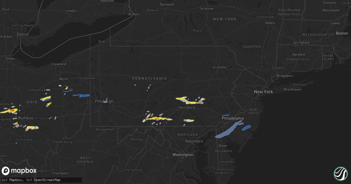
Hail Map in Pennsylvania on June 4, 2020
Get this storm
June 4 map
$229
one time, instant access
Download today. No call, no setup
Keep the $229
Bought the map and want the full workflow? Apply the entire $229 to a subscription within 7 days. None of it is wasted.
Every map, not just this one
This buys you this map. Subscription and you get every map we run, in the markets you choose from a few cities to whole states to nationwide. Plus real-time alerts the moment a storm fires.
Contact data
Name, contact info, occupancy, even credit band for addresses in the footprint. You go from where it hit to who to call.
Become the source they trust
Unlimited branding weather history reports on demand. You already have the documented answer ready for the property owner, and you are the one who showed up with it.
Property data and RoofTrace estimates
Pull up any address you have got, its value and the exact code rules for that jurisdiction, straight from One Click Code. Then RoofTrace estimates the squares, pitch, and roof value, priced the way you price.
Storm reports in Pennsylvania
Pennsylvania
| Date | Description |
|---|---|
| 06/04/20206:32 PM CDT | Trees down on wires. |
| 06/04/20206:32 PM CDT | Trees down on wires. |
| 06/04/20206:25 PM CDT | Multiple trees down in loganville. |
| 06/04/20206:25 PM CDT | A local report indicates 1.00 inch wind near LOGANVILLE |
| 06/04/20206:24 PM CDT | A local report indicates 1.00 inch wind near DALLASTOWN |
| 06/04/20206:15 PM CDT | Reported at loganville... York... Pa. Large trees down/snapped in half. |
| 06/04/20206:15 PM CDT | Reported at loganville... York... Pa. Ping pong hail. |
| 06/04/20206:15 PM CDT | Trees and wires down in wayne township. |
| 06/04/20206:03 PM CDT | Multiple trees and branches down. |
| 06/04/20206:02 PM CDT | Trees and wires down. |
| 06/04/20206:02 PM CDT | Trees and wires down. |
| 06/04/20206:00 PM CDT | Cwop site. |
| 06/04/20205:52 PM CDT | Large tree down on a house. |
| 06/04/20205:50 PM CDT | Tree and wires down. |
| 06/04/20205:48 PM CDT | Trees across route 11. Road closed. |
| 06/04/20205:47 PM CDT | Tree down on a house. |
| 06/04/20205:38 PM CDT | Trees down across hill road. |
| 06/04/20205:34 PM CDT | Tree down on house. Time estimated from radar. |
| 06/04/20205:33 PM CDT | Tree on house and numerous trees down throughout east berlin. |
| 06/04/20205:32 PM CDT | A couple of reports of power lines down near west state street. Time estimated from radar. |
| 06/04/20205:30 PM CDT | A few trees reported down in bernville. Also a couple of sporadic downed tree reports in nearby areas. Time estimated from radar. |
| 06/04/20205:17 PM CDT | Tree down in jackson township. |
| 06/04/20205:09 PM CDT | Trees down on wires west of scotland. |
| 06/04/20205:03 PM CDT | Trees and wires down near needmore. |
| 06/04/20205:03 PM CDT | Trees and wires down on south 3rd st. |
| 06/04/20205:02 PM CDT | Tree down on wires. |
| 06/04/20205:01 PM CDT | Trees and wires down on marion road. |
| 06/04/20205:00 PM CDT | Trees down on wires in north philipsburg. |
| 06/04/20204:58 PM CDT | Reported at 1 mi north of biglerville pa. Shed damaged and pine trees blown down. |
| 06/04/20204:56 PM CDT | Downed wires near schubert road. Time estimated from radar. |
| 06/04/20204:55 PM CDT | Trees down along great cove road. |
| 06/04/20204:48 PM CDT | Trees and wires down on lemar road. |
| 06/04/20204:40 PM CDT | Downed wires near kline road and route 419. Time estimated from radar. |
| 06/04/20204:30 PM CDT | Large tree down on power lines |
| 06/04/20204:27 PM CDT | Tree down on wires in arendtsville. |
| 06/04/20204:24 PM CDT | Tree came down on wires in the area. State route 88 was closed in both directions between grandview way and i70 wb ramp. |
| 06/04/20204:22 PM CDT | Reported at 176 dicks dam road... Reading. A large storage barn is reported to have blown across the road. |
| 06/04/20204:19 PM CDT | Trees and wires down in the roadway |
| 06/04/20204:17 PM CDT | Multiple trees down on wires. Time estimated from radar. |
| 06/04/20204:13 PM CDT | Trees down on wires. |
| 06/04/20204:10 PM CDT | Multiple trees and wires down across route 443. |
| 06/04/20204:09 PM CDT | Tree down blocking entire roadway |
| 06/04/20204:08 PM CDT | Multiple trees down in wayne township. Time estimated from radar. |
| 06/04/20204:02 PM CDT | Trees down on wires. |
| 06/04/20204:00 PM CDT | Multiple trees down. Part of garage roof blown off. |
| 06/04/20203:59 PM CDT | Tree down blocking a lane of travel. |
| 06/04/20203:58 PM CDT | Medium-sized tree fell on a home on proctor way. Tree lying on gutter... No damage to house. |
| 06/04/20203:56 PM CDT | Tree reported to be down blocking entire roadway. |
| 06/04/20203:55 PM CDT | Healthy 20 foot tree and several brances downed one half mile west of i-80/i-79 interchange. Time estimated from radar. |
| 06/04/20203:55 PM CDT | Tree down on roadway at allegheny river blvd and washington blvd. |
| 06/04/20203:54 PM CDT | Numerous trees and wires down. |
| 06/04/20203:54 PM CDT | Trees down on wires with outage. |
| 06/04/20203:51 PM CDT | Allegheny county 911 reports tree down at scott road and jonquil place |
| 06/04/20203:50 PM CDT | Photo on social media of a large tree down across the road in mcmurray along with large branches of the surrounding trees |
| 06/04/20203:48 PM CDT | Numerous trees down. Tree on house. |
| 06/04/20203:45 PM CDT | Tree down blocking all lanes on bower hill rd by painters run rd. |
| 06/04/20203:45 PM CDT | Trees and wires down on a vehcile at vanadium rd and insurrection ave. |
| 06/04/20203:45 PM CDT | 911 center reports tree and wires down on roadway at hilltop road and walkers mill rd. |
| 06/04/20203:39 PM CDT | Tree down blocking the roadway at 5th and penn alley in mckees rocks |
| 06/04/20203:39 PM CDT | Reported at state college. Large tree on road. |
| 06/04/20203:38 PM CDT | Trees and wires completely blocking red hill road. |
| 06/04/20203:38 PM CDT | Trees down on wires. |
| 06/04/20203:36 PM CDT | Numerous trees and wires down completely across north 4th st and creek road. |
| 06/04/20203:36 PM CDT | Numerous trees completely blocking juniata parkway. Car trapped. |
| 06/04/20203:35 PM CDT | Reported at state college. Up to quarter sized hail. |
| 06/04/20203:34 PM CDT | Numerous trees down across trout road. |
| 06/04/20202:30 PM CDT | Quarter size hail covered the ground like snow around the post office. |
| 06/04/20202:28 PM CDT | Reported at ayr township pa. Accumulation of hail up to ping pong sized. |
| 06/04/20202:22 PM CDT | Quarter size hail covered the ground in harrissonville. |
| 06/04/20202:15 PM CDT | Reported at fulton county pa route 30. Quarter sized hail. Radar estimated time. |
| 06/04/20202:13 PM CDT | Reported at fulton medical center... Pa. Video showing many ping-pong sized hailstones falling. |
| 06/04/20202:00 PM CDT | Reported at osterburg. Up to quarter inch hail. |
| 06/04/20202:41 AM CDT | At 740 PM EDT, severe thunderstorms were located along a line extending from near Mcalisterville to near Wertzville, moving northeast at 35 mph. HAZARD...60 mph wind gusts. SOURCE...Radar indicated. IMPACT...Expect damage to trees, roofs, and siding. Locations impacted include... Harrisburg, Lebanon, Lower Allen, Hershey, Colonial Park, Sunbury, Progress, Mechanicsburg, Camp Hill, Palmyra, New Cumberland, Linglestown, Enola, Selinsgrove, Annville, Lemoyne, Myerstown, Paxtonia, Rutherford and Skyline View.This includes the following Interstates... The Pennsylvania Turnpike near mile marker 232. Interstate 78 from mile markers 0 to 7. Interstate 81 from mile markers 55 to 98. Interstate 83 between mile markers 42 and 45...and from mile markers47 to 50.This includes the following COVID-19 Test Sites... Colonial Park Harrisburg Urgent Care...Family Practice Enola...Family Practice Selinsgrove...Geisinger Holy Spirit ...Rite Aid...and UPMC Pinnacle. |
| 06/04/20202:20 AM CDT | At 719 PM EDT, a severe thunderstorm was located over Marysville, moving northeast at 55 mph. HAZARD...60 mph wind gusts. SOURCE...Radar indicated. IMPACT...Expect damage to trees, roofs, and siding. Locations impacted include... Harrisburg, Camp Hill, Linglestown, Enola, Marysville, and Paxtang.This includes the following Interstates... Interstate 81 from mile markers 59 to 81. Interstate 83 from mile markers 40 to 50. Interstate 283 near mile marker 2.This includes the following COVID-19 Test Sites... Colonial Park Harrisburg Urgent Care...Family Practice Enola...Geisinger Holy Spirit ...Rite Aid...and UPMC Pinnacle. |
| 06/04/20202:13 AM CDT | At 711 PM EDT, severe thunderstorms were located along a line extending from near DuBois to near Curwensville to 10 miles north of Prince Gallitzin State Park to near Patton, moving northeast at 30 mph. HAZARD...60 mph wind gusts and penny size hail. SOURCE...Radar indicated. IMPACT...Expect damage to trees, roofs, and siding. Severe thunderstorms will be near... Curwensville around 720 PM EDT. Clearfield, Penfield, Hyde, Jeffries, Plymptonville, Blandburg, Houtzdale, Bellwood and S.B. Elliot State Park around 730 PM EDT. Tipton, Woodland, Parker Dam State Park and Osceola Mills around 740 PM EDT. Tyrone, North Philipsburg, Philipsburg, Lecontes Mills, Chester Hill, South Philipsburg and Birmingham around 750 PM EDT.For those driving on Interstate 80, this includes areas between theDubois and Milesburg exits, specifically from mile markers 97 to 148.This includes Interstate 99 from mile markers 41 to 72. |
| 06/04/20201:57 AM CDT | At 656 PM EDT, a severe thunderstorm was located over Carlisle, moving northeast at 35 mph. This storm has done wind damage in Shippensburg. HAZARD...60 mph wind gusts. SOURCE...Radar indicated. IMPACT...Expect damage to trees, roofs, and siding. Locations impacted include... Harrisburg, Carlisle, Lower Allen, Mechanicsburg, Camp Hill, New Cumberland, Enola, Lemoyne, Plainfield, Schlusser, Boiling Springs, Wormleysburg, Marysville, Mount Holly Springs, Shiremanstown, Duncannon, West Fairview, New Kingstown, New Buffalo and Hogestown.This includes the following Interstates... The Pennsylvania Turnpike from mile markers 218 to 236. Interstate 81 from mile markers 42 to 65. Interstate 83 from mile markers 41 to 42.This includes the following COVID-19 Test Sites... Family Practice Enola...Geisinger Holy Spirit ...Geisinger Holy Spirit Jennifer Court...and UPMC Carlisle Outpatient Surgery Center. |
| 06/04/20201:55 AM CDT | At 654 PM EDT, severe thunderstorms were located along a line extending from near Trough Creek State Park to 7 miles northeast of Roxbury, moving northeast at 35 mph. HAZARD...60 mph wind gusts. SOURCE...Radar indicated. IMPACT...Expect damage to trees, roofs, and siding. Locations impacted include... Lewistown, Huntingdon, Mount Union, Burnham, Belleville, Newport, Duncannon, Highland Park, Newville, Honey Grove, New Bloomfield, Yeagertown, Spruce Hill, Strodes Mills, Reedsville, Juniata Terrace, Allensville, Mexico, East Waterford and New Buffalo.This includes The Pennsylvania Turnpike from mile markers 205 to 217.This includes the following COVID-19 Test Sites... Central Pennsylvania Clinic...Geisinger Lewistown Hospital...and QuickLab Huntingdon. |
| 06/04/20201:42 AM CDT | At 641 PM EDT, a severe thunderstorm was located over Leesport, or 7 miles north of Reading, moving east at 30 mph. HAZARD...60 mph wind gusts and penny size hail. SOURCE...Radar indicated. IMPACT...Damage to roofs, siding, trees, and power lines is possible. Locations impacted include... Allentown, Reading, Bethlehem, Emmaus, Wyomissing, Northampton, Quakertown, Kutztown, Hamburg, Fleetwood, Sinking Spring, Laureldale, East Greenville, Topton, Leesport, Shoemakersville, Bally, Bechtelsville, Green Lane and Lyons.This includes the following highways... Interstate 78 in Pennsylvania between mile markers 27 and 63. Northeast Extension between exits A44 and A56. |
| 06/04/20201:31 AM CDT | At 629 PM EDT, a severe thunderstorm was located over York Airport, moving east at 40 mph. HAZARD...60 mph wind gusts and quarter size hail. SOURCE...Radar indicated. IMPACT...Hail damage to vehicles is expected. Expect wind damage to trees, roofs, and siding. Locations impacted include... York, Hanover, Weigelstown, Red Lion, Spry, Dallastown, Shiloh, East York, Stonybrook-Wilshire, West York, Shrewsbury, Codorus, Grantley, Tyler Run-Queens Gate, Manchester, Hallam, Emigsville, Spring Grove, Glen Rock and Dover.This includes Interstate 83 from mile markers 4 to 24.This includes the following COVID-19 Test Sites... Old Memorial Hospital...Rite Aid...WellSpan Health...Wellspan Pediatrics/Wellspan OB/GYN...York Expo Center...and York VA Community Clinic. |
| 06/04/20201:28 AM CDT | At 628 PM EDT, a severe thunderstorm was located over Fannettsburg, moving northeast at 30 mph. This storm has produced wind damage already. HAZARD...60 mph wind gusts. SOURCE...Radar indicated. IMPACT...Expect damage to trees, roofs, and siding. Locations impacted include... Newville, Upper Strasburg, Roxbury, Willow Hill, Big Spring State Park, Doylesburg, Fannettsburg, Orrstown, Shade Gap and New Germantown.This includes The Pennsylvania Turnpike from mile markers 185 to 214. |
| 06/04/20201:25 AM CDT | At 625 PM EDT, a severe thunderstorm was located near Shippensburg, moving northeast at 30 mph. HAZARD...60 mph wind gusts. SOURCE...Radar indicated. IMPACT...Expect damage to trees, roofs, and siding. This severe thunderstorm will be near... Walnut Bottom and Pine Grove Furnace around 630 PM EDT. Newville around 640 PM EDT. Plainfield and Mount Holly Springs around 650 PM EDT. Carlisle, Schlusser, Carlisle Springs, Boiling Springs and New Kingstown around 700 PM EDT.Other locations impacted by this severe thunderstorm include PennState Dickinson School Of Law and Shippensburg University.This includes the following Interstates... The Pennsylvania Turnpike from mile markers 217 to 235. Interstate 81 from mile markers 26 to 53.This includes the following COVID-19 Test Sites... Geisinger Holy Spirit Jennifer Court...and UPMC Carlisle Outpatient Surgery Center. |
| 06/04/20201:09 AM CDT | At 609 PM EDT, a severe thunderstorm was located near Clearville, moving northeast at 25 mph. HAZARD...60 mph wind gusts. SOURCE...Radar indicated. IMPACT...Expect damage to trees, roofs, and siding. Locations impacted include... Bedford, Clearville, Everett and Hopewell. This includes The Pennsylvania Turnpike from mile markers 147 to 159.This includes the following COVID-19 Test Sites... Hyndman Health Center...and UPMC Bedford Memorial. |
| 06/04/202012:53 AM CDT | At 553 PM EDT, a severe thunderstorm was located over North Philipsburg, moving northeast at 30 mph. HAZARD...60 mph wind gusts. SOURCE...Radar indicated. IMPACT...Expect damage to trees, roofs, and siding. Locations impacted include... Philipsburg, Osceola Mills, Chester Hill, North Philipsburg, South Philipsburg, Pine Glen, Black Moshannon State Park, Morrisdale, West Decatur, Grassflat, Kylertown and Wallaceton.For those driving on Interstate 80, this includes areas between theWoodland and Snow Shoe exits, specifically from mile markers 125 to143.This includes the following COVID-19 Test Sites... Laboratory Collection Site Philipsburg. |
| 06/04/202012:43 AM CDT | At 542 PM EDT, a severe thunderstorm was located over Harper Tavern, moving east at 40 mph. HAZARD...70 mph wind gusts and quarter size hail. SOURCE...Emergency management. IMPACT...Hail damage to vehicles is expected. Expect considerable tree damage. Wind damage is also likely to mobile homes, roofs, and outbuildings. Locations impacted include... Lebanon, Palmyra, Annville, Cornwall, Myerstown, Pleasant Hill, Sand Hill, Newmanstown, Lebanon South, Pine Grove, Cleona, Avon, Richland, Fredericksburg, Tower City, Schaefferstown, Quentin, Harper Tavern, Lickdale and Fort Indiantown Gap.This includes the following Interstates... Interstate 78 from mile markers 0 to 8. Interstate 81 from mile markers 82 to 103.This includes the following COVID-19 Test Sites... Good Samaritan Hospital...Lebanon VA Medical Center...MedExpress Urgent Care...and WellSpan Health. |
| 06/04/202012:39 AM CDT | At 538 PM EDT, a severe thunderstorm was located over Harper Tavern, or near Annville, moving east at 30 mph. HAZARD...60 mph wind gusts and quarter size hail. SOURCE...Radar indicated. IMPACT...Minor damage to vehicles is possible. Wind damage to roofs, siding, trees, and power lines is possible. Locations impacted include... Reading, Wyomissing, Hamburg, Sinking Spring, Laureldale, Womelsdorf, Wernersville, Robesonia, Leesport, Shoemakersville, Bernville, Strausstown, Lenhartsville, Spring Ridge, Fairview Hgts, Shillington, West Reading, Mount Penn, Mohnton and Kenhorst.This includes the following highways... Interstate 78 in Pennsylvania between mile markers 10 and 37. Interstate 176 in Pennsylvania between mile markers 7 and 11. |
| 06/04/202012:15 AM CDT | At 515 PM EDT, a severe thunderstorm was located near Lickdale, moving northeast at 25 mph. HAZARD...70 mph wind gusts and quarter size hail. SOURCE...Radar indicated. IMPACT...Hail damage to vehicles is expected. Expect considerable tree damage. Wind damage is also likely to mobile homes, roofs, and outbuildings. Locations impacted include... Pottsville, Schuylkill Haven, Shenandoah, Minersville, Mahanoy City, Frackville, St. Clair, Orwigsburg, Pine Grove, Port Carbon, Tremont, Tuscarora, New Philadelphia, Friedensburg, Grier City-Park Crest, Marlin, Altamont, Renningers, Englewood and Delano.This includes Interstate 81 between mile markers 95 and 113...betweenmile markers 118 and 119...and from mile markers 122 to 133.This includes the following COVID-19 Test Sites... Geisinger Orwigsburg...Geisinger St. Luke's Hospital...and Lehigh Valley Health Network. |
| 06/04/202012:11 AM CDT | At 510 PM EDT, a severe thunderstorm was located near Grove City, moving east at 30 mph. HAZARD...Wind gusts to 60 mph. SOURCE...Radar. IMPACT...Expect damage to trees and power lines, resulting in some power outages. Locations impacted include... Oil City... Grove City... Clarion... Knox... Slippery Rock... Seneca... Harrisville... Parker... Plain Grove Township... Sligo... Emlenton... Clintonville...This includes the following highways... Interstate 79 in Pennsylvania between mile markers 108 and 119. Interstate 80 in Pennsylvania between mile markers 17 and 64. |
| 06/03/202011:36 PM CDT | At 435 PM EDT, a severe thunderstorm was located over Scotland, moving east at 20 mph. HAZARD...60 mph wind gusts and nickel size hail. SOURCE...Radar indicated. IMPACT...Expect damage to trees, roofs, and siding. Locations impacted include... Chambersburg, Guilford, Fayetteville, Scotland, Cashtown, Aspers, Pine Grove Furnace, Biglerville, Arendtsville, Bendersville, McKnightstown and Gardners.This includes Interstate 81 from mile markers 14 to 26.This includes the following COVID-19 Test Sites... Chambersburg Community Assessment Site...Keystone Health...and WellSpan Health. |
| 06/03/202011:35 PM CDT | At 435 PM EDT, a severe thunderstorm was located over Newport, moving east at 35 mph. HAZARD...70 mph wind gusts and quarter size hail. SOURCE...Radar indicated. IMPACT...Hail damage to vehicles is expected. Expect considerable tree damage. Wind damage is also likely to mobile homes, roofs, and outbuildings. Locations impacted include... Millersburg, Lykens, Newport, Elizabethville, New Buffalo, Klingerstown, Leck Kill, Urban, Dehart Dam, Liverpool, Wiconisco, Halifax, Gratz, Thompsontown, Millerstown, Dalmatia, Berrysburg, Pillow, East Salem and Enders. |
| 06/03/202010:23 PM CDT | At 322 PM EDT, a severe thunderstorm was located over Harrisonville, moving east at 25 mph. HAZARD...Ping pong ball size hail and 60 mph wind gusts. SOURCE...Radar indicated. IMPACT...People and animals outdoors will be injured. Expect hail damage to roofs, siding, windows, and vehicles. Expect wind damage to trees, roofs, and siding. Locations impacted include... Chambersburg, Greencastle, St. Thomas, Mercersburg, McConnellsburg, Harrisonville, Marion, Fort Loudon, Saluvia, Upper Strasburg, Willow Hill, Fannettsburg, Roxbury, Williamson and Upton.This includes the following Interstates... The Pennsylvania Turnpike between mile markers 177 and 184...andfrom mile markers 187 to 193. Interstate 81 from mile markers 5 to 16.This includes the following COVID-19 Test Sites... Chambersburg Community Assessment Site...Fulton County Medical Center...Keystone Health...and WellSpan Health. |
| 06/03/202010:11 PM CDT | At 310 PM EDT, a severe thunderstorm was located over Saluvia, moving northeast at 25 mph. HAZARD...70 mph wind gusts and quarter size hail. SOURCE...Radar indicated. IMPACT...Hail damage to vehicles is expected. Expect considerable tree damage. Wind damage is also likely to mobile homes, roofs, and outbuildings. Locations impacted include... Harrisonville, Waterfall, Rockhill Furnace, Wells Tannery, Fort Littleton, Dudley, Valley-Hi, Saluvia, Doylesburg, Trough Creek State Park, Willow Hill, Sideling Hill Rest Area, Fannettsburg, Broad Top City, Three Springs, Orbisonia, Saltillo, Marklesburg, Shirleysburg and Cassville.This includes The Pennsylvania Turnpike from mile markers 165 to 197. |
| 06/03/20209:55 PM CDT | Wires were downed on golf blvd. Time estimated from radar. |
| 06/03/20209:47 PM CDT | Corrects time of previous tstm wnd dmg report from 1 wnw media. Wires down on n ridley creek rd. Time estimated from radar. |
| 06/03/20209:45 PM CDT | Wires down on country village way. Time estimated from radar. |
| 06/03/20209:40 PM CDT | Corrects time of previous tstm wnd dmg report from parkside. Wires down on schoolhouse ln. Time estimated from radar. |
| 06/03/20209:40 PM CDT | Corrects time of previous tstm wnd dmg report from swarthmore. Wires down on yale ave. Time estimated from radar. |
| 06/03/20208:47 PM CDT | Wires down on n ridley creek rd. Time estimated from radar. |
| 06/03/20208:40 PM CDT | Wires down on schoolhouse ln. Time estimated from radar. |
| 06/03/20208:40 PM CDT | Wires down on yale ave. Time estimated from radar. |
| 06/03/20207:31 PM CDT | Trees down on wires on marietta avenue. |
| 06/03/20207:21 PM CDT | Trees down on wires. |
All States Impacted by Hail Map on June 4, 2020
Cities Impacted by Hail Map on June 4, 2020
- Lincoln, NE
- Smith Center, KS
- Lebanon, KS
- Red Cloud, NE
- Riverton, NE
- Burr Oak, KS
- Inavale, NE
- Laverne, OK
- Claude, TX
- Duncan, OK
- Milford, IA
- Spearfish, SD
- Utica, NE
- Waco, NE
- Benedict, NE
- York, NE
- Gresham, NE
- Steamboat Rock, IA
- Silverton, TX
- Harrisonville, PA
- Gail, TX
- Fluvanna, TX
- Bladen, NE
- Ulysses, KS
- Ida Grove, IA
- Memphis, TN
- Germantown, TN
- Maryneal, TX
- Mechanicsville, IA
- Tipton, IA
- Hart, TX
- Hale Center, TX
- Olton, TX
- Plainview, TX
- Saint Onge, SD
- Whitewood, SD
- Belle Fourche, SD
- Beulah, WY
- Aladdin, WY
- Saint George, KS
- Danville, WV
- Seth, WV
- Madison, WV
- Peytona, WV
- Turtle Creek, WV
- Foster, WV
- Lubbock, TX
- Decatur, TX
- Hebron, NE
- Needmore, PA
- McConnellsburg, PA
- Fort Loudon, PA
- Mercersburg, PA
- Humboldt, IA
- Milesville, SD
- Midland, SD
- Gillette, WY
- Hendricks, MN
- Waverly, IA
- Sumner, IA
- Tripoli, IA
- Vesuvius, VA
- Raphine, VA
- Robert Lee, TX
- Stratford, IA
- Rozet, WY
- Pleasant Dale, NE
- Milford, NE
- Terril, IA
- La Porte City, IA
- Bremen, KS
- Marysville, KS
- Clifton, KS
- Palmer, KS
- Linn, KS
- Clay Center, KS
- Cordova, TN
- Liberal, KS
- Hugoton, KS
- Martin, SD
- Allen, SD
- Tuthill, SD
- Wellfleet, NE
- Warsaw, OH
- Blissfield, OH
- Walhonding, OH
- Canadian, TX
- Ruthton, MN
- Salem, NE
- Morrill, KS
- Hiawatha, KS
- Sabetha, KS
- Clarendon, TX
- Mobeetie, TX
- Miami, TX
- Hill City, SD
- Deadwood, SD
- Rapid City, SD
- Lead, SD
- Masonville, IA
- Lamont, IA
- Winthrop, IA
- Ellsworth Afb, SD
- Devils Tower, WY
- Scenic, SD
- Sturgis, SD
- Nemo, SD
- New Underwood, SD
- Piedmont, SD
- Sundance, WY
- Hermosa, SD
- Moorcroft, WY
- Wasta, SD
- Caputa, SD
- Box Elder, SD
- Black Hawk, SD
- Wanblee, SD
- Kyle, SD
- Gilmore City, IA
- Tulia, TX
- Cimarron, KS
- Dupree, SD
- Faith, SD
- Comstock, NE
- Haddam, KS
- Morrowville, KS
- Grantville, PA
- Palmyra, PA
- Annville, PA
- Harrisburg, PA
- Ratliff City, OK
- Graham, OK
- Lakefield, MN
- Windom, MN
- Bethel, PA
- Myerstown, PA
- Hulett, WY
- Lorenzo, TX
- Floydada, TX
- Ralls, TX
- Post, TX
- Reva, SD
- Prairie City, SD
- Grundy Center, IA
- Buckingham, IA
- Reinbeck, IA
- Traer, IA
- Lincoln, IA
- Morrison, IA
- Gladbrook, IA
- Wichita Falls, TX
- Alzada, MT
- Broadus, MT
- Fulda, MN
- Worthington, MN
- Brewster, MN
- Limestone, TN
- Chuckey, TN
- West Jefferson, OH
- London, OH
- Mount Sterling, OH
- Orient, OH
- Erick, OK
- Millersburg, PA
- Millerstown, PA
- Liverpool, PA
- Newport, PA
- Halifax, PA
- Duncannon, PA
- Dauphin, PA
- Seward, NE
- Clearville, PA
- Everett, PA
- Olsburg, KS
- Amanda, OH
- Lancaster, OH
- Circleville, OH
- Ashville, OH
- Stoutsville, OH
- York, PA
- Seven Valleys, PA
- Spring Grove, PA
- York New Salem, PA
- Dallastown, PA
- Luray, KS
- Fargo, OK
- Gage, OK
- Shattuck, OK
- Pocahontas, IA
- Cuba, KS
- Agenda, KS
- Saint Francis, SD
- Perryton, TX
- Kress, TX
- Heron Lake, MN
- Battle Creek, IA
- Philipsburg, PA
- Del Rio, TN
- Everest, KS
- Sargent, NE
- Broken Bow, NE
- Anselmo, NE
- Dike, IA
- Parkersburg, IA
- Valentine, NE
- Hardesty, OK
- Iowa Falls, IA
- Alden, IA
- Glasgow, VA
- Buena Vista, VA
- Natural Bridge, VA
- Natural Bridge Station, VA
- Buchanan, VA
- Montvale, VA
- Russell, MN
- Balaton, MN
- Tyler, MN
- Sayre, OK
- Temple, OK
- Waurika, OK
- Walters, OK
- Hastings, OK
- Alva, WY
- Quitaque, TX
- Lehigh, IA
- Webster City, IA
- Stanhope, IA
- Duncombe, IA
- Milford Center, OH
- Marysville, OH
- Edgemont, SD
- Wadena, IA
- Arlington, IA
- Elkader, IA
- Fayette, IA
- Strawberry Point, IA
- Volga, IA
- Loveland, OK
- Balko, OK
- Big Spring, TX
- Coahoma, TX
- Tahoka, TX
- Odonnell, TX
- Guide Rock, NE
- Superior, NE
- Hudson, IA
- Waterloo, IA
- Hartley, IA
- Melvin, IA
- Cherry Creek, SD
- Jetmore, KS
- Ingalls, KS
- Frankfort, KS
- Matador, TX
- Garvin, MN
- Jewell, KS
- Beloit, KS
- Randall, KS
- Follett, TX
- Booker, TX
- Deshler, NE
- Big Prairie, OH
- Glenmont, OH
- Killbuck, OH
- Norton, KS
- Nelson, NE
- Ruskin, NE
- Hardy, NE
- Moscow, KS
- Wheeler, TX
- Briscoe, TX
- Concordia, KS
- Scandia, KS
- Belleville, KS
- Manhattan, KS
- May, OK
- Tarkio, MO
- Letart, WV
- Aurelia, IA
- Exeter, NE
- Fairmont, NE
- McCool Junction, NE
- Mission, SD
- Hawkeye, IA
- Lebanon, MO
- Fonda, IA
- Henrietta, TX
- Atalissa, IA
- West Liberty, IA
- Waterloo, NE
- Ashland, NE
- Elkhorn, NE
- Gretna, NE
- Nocona, TX
- Osco, IL
- Cambridge, IL
- Crystal Spring, PA
- Chambersburg, PA
- Breezewood, PA
- Saint Thomas, PA
- Warfordsburg, PA
- Sugar Grove, OH
- Logan, OH
- Bremen, OH
- Guymon, OK
- Lockney, TX
- Justiceburg, TX
- Petersburg, TX
- Dimmitt, TX
- Happy, TX
- Wheatland, IA
- Blue Ridge, VA
- Vinton, VA
- Lexington, VA
- Roanoke, VA
- Belvidere, NE
- Fairbury, NE
- Reynolds, NE
- Bruning, NE
- Gilead, NE
- Strang, NE
- Chester, NE
- Ohiowa, NE
- Alexandria, NE
- Hubbell, NE
- Paw Paw, WV
- Wamego, KS
- Alma, KS
- Paxico, KS
- Webber, KS
- Mankato, KS
- Courtland, KS
- Holly Springs, MS
- Buffalo, SD
- Bison, SD
- Arnett, OK
- Sharon, OK
- Mena, AR
- Clearmont, WY
- Buffalo, WY
- Shallowater, TX
- New Deal, TX
- Nazareth, TX
- Abernathy, TX
- Jackson, MN
- Crown Point, IN
- Campbell, NE
- Upland, NE
- Blackwater, MO
- Liscomb, IA
- Marshalltown, IA
- Fort Dodge, IA
- Arthur, IA
- Crawford, OK
- Morganville, KS
- Clyde, KS
- Walker, IA
- Coggon, IA
- Glasco, KS
- Aurora, KS
- Delphos, KS
- Saint Marys, KS
- Slayton, MN
- Ord, NE
- Shelbyville, MO
- West Branch, IA
- Garden City, KS
- Sublette, KS
- Satanta, KS
- Interior, SD
- Canton, OH
- Tussy, OK
- Healdton, OK
- Flomot, TX
- Rushville, NE
- Hay Springs, NE
- Hemingford, NE
- Mahaska, KS
- Evansdale, IA
- Raymond, IA
- Du Bois, NE
- Pierceville, KS
- Potts Camp, MS
- Rulo, NE
- Craig, MO
- Raymond, NE
- Chadron, NE
- Marsland, NE
- Pine Grove, PA
- Spearman, TX
- Loraine, TX
- Okeene, OK
- Newcastle, WY
- Custer, SD
- Watson, OK
- Cove, AR
- Edgar, NE
- Hammon, OK
- Reydon, OK
- Durham, OK
- Belvue, KS
- Thedford, NE
- Ryan, OK
- Millersburg, OH
- Danville, OH
- Willow, OK
- Granite, OK
- Alex, OK
- Malcolm, NE
- Garland, NE
- Parmelee, SD
- Cement, OK
- Cyril, OK
- Fletcher, OK
- Eskridge, KS
- Maple Hill, KS
- Orrtanna, PA
- Hopewell, PA
- Bedford, PA
- Fayetteville, PA
- Home, KS
- Beattie, KS
- Mound City, MO
- Maitland, MO
- Oregon, MO
- Fillmore, MO
- Sutton, NE
- Ivanhoe, MN
- Arco, MN
- Blairsburg, IA
- Ira, TX
- Spirit Lake, IA
- Greenville, IA
- Gillett Grove, IA
- Marcus, IA
- Meriden, IA
- Cleghorn, IA
- Cherokee, IA
- Randlett, OK
- New Providence, IA
- Fort Pierre, SD
- Meadow, SD
- Hayes, SD
- Okaton, SD
- Westbrook, TX
- Colorado City, TX
- Spencer, IA
- Geneva, NE
- Panhandle, TX
- Purdum, NE
- Brownville, NE
- Falls City, NE
- Westboro, MO
- Peru, NE
- Watson, MO
- Skidmore, MO
- Fairfax, MO
- Nemaha, NE
- Rock Port, MO
- Fort Supply, OK
- Remsen, IA
- Thomson, IL
- Calamus, IA
- Eads, TN
- Palmer, IA
- Simpson, KS
- Clarence, IA
- Solon, IA
- Iowa City, IA
- Lisbon, IA
- Julian, NE
- Brock, NE
- Nebraska City, NE
- Oberlin, KS
- Jennings, KS
- Dresden, KS
- Annandale, VA
- Fairfax, VA
- Springfield, VA
- Leonardville, KS
- Riley, KS
- Smithville, OK
- Ulysses, NE
- Surprise, NE
- Stromsburg, NE
- Shelby, NE
- Osceola, NE
- Staplehurst, NE
- Rising City, NE
- Holland, MN
- Woodstock, MN
- Burwell, NE
- Thor, IA
- Alvord, TX
- Whitney, NE
- Delaware, OH
- Afton, TN
- Bellevue, TX
- Bowie, TX
- Hollenberg, KS
- Washington, KS
- Narka, KS
- Dayton, IA
- Plain City, OH
- Rosston, OK
- Gate, OK
- Westbrook, MN
- Randolph, KS
- Chattanooga, OK
- Bradgate, IA
- Rutland, IA
- Okabena, MN
- Hanover, KS
- Fairfield, NE
- Shickley, NE
- Grafton, NE
- Saronville, NE
- Henderson, NE
- Friend, NE
- Munden, KS
- Clay Center, NE
- Cordova, NE
- Osceola, AR
- Etowah, AR
- Keiser, AR
- Wilson, OK
- Ringling, OK
- Forestburg, TX
- Dows, IA
- Alliance, NE
- Hermleigh, TX
- Thomasville, PA
- Red Lion, PA
- Dawson, NE
- Nokesville, VA
- Gainesville, VA
- Bristow, VA
- Cheyenne, OK
- Coldwater, MS
- Byhalia, MS
- Hernando, MS
- Buffalo, OK
- Osceola Mills, PA
- Crawford, NE
- Saint Jo, TX
- Troy, KS
- Forest City, MO
- Wathena, KS
- Long Island, VA
- Boones Mill, VA
- Williamsburg, IA
- Brewster, NE
- Westmoreland, KS
- Sanborn, IA
- Archer, IA
- Sheldon, IA
- Primghar, IA
- Moscow, IA
- Carleton, NE
- Geary, OK
- Lindsay, OK
- Springer, OK
- Bassett, NE
- Myrtle, MS
- Hickory Flat, MS
- Roaring Springs, TX
- Alcester, SD
- Hawarden, IA
- Dolliver, IA
- Wellsburg, IA
- Topeka, KS
- Ferrum, VA
- East Moline, IL
- Bettendorf, IA
- Brainard, NE
- Hazleton, IA
- Aurora, IA
- Stanley, IA
- Independence, IA
- Amarillo, TX
- Crowell, TX
- Upton, WY
- Woodstock, OH
- North Lewisburg, OH
- Urbana, OH
- Mechanicsburg, OH
- Cable, OH
- Irwin, OH
- Dixon, IA
- Donahue, IA
- Canyon, TX
- Wilton, IA
- Muscatine, IA
- Stanberry, MO
- King City, MO
- Guilford, MO
- Rossville, TN
- Everly, IA
- Hospers, IA
- Fostoria, IA
- Orange City, IA
- Alton, IA
- Estherville, IA
- Fredericksburg, IA
- Shamrock, TX
- Berkeley Springs, WV
- Bloomery, WV
- Great Cacapon, WV
- Oketo, KS
- Camdenton, MO
- Watonga, OK
- Lexington, OK
- Dunbar, NE
- Syracuse, NE
- Southaven, MS
- Nesbit, MS
- Olive Branch, MS
- Horn Lake, MS
- Greeneville, TN
- Krum, TX
- Ponder, TX
- Zanesfield, OH
- West Liberty, OH
- Rockbridge Baths, VA
- Weinert, TX
- O'Brien, TX
- Munday, TX
- Conception Junction, MO
- Butler, OK
- Union, IA
- Norway, KS
- Jamestown, KS
- Mahaffey, PA
- Punxsutawney, PA
- Glen Campbell, PA
- Raymond, OH
- Abbottstown, PA
- Winston, MO
- West Union, IA
- Marengo, IA
- Robinson, KS
- Muenster, TX
- Currie, MN
- Alpha, MN
- Saint Joseph, MO
- Cole Camp, MO
- Hardy, VA
- Fairfield, VA
- Roberts, MT
- Absarokee, MT
- Fishtail, MT
- Manchester, MD
- Westminster, MD
- Lebanon, PA
- Ono, PA
- Richland, PA
- Womelsdorf, PA
- Fredericksburg, PA
- Jonestown, PA
- Willow Hill, PA
- Fannettsburg, PA
- Woodward, OK
- Bainbridge, OH
- Parrottsville, TN
- Hereford, TX
- Edwards, MO
- Lincoln, MO
- Warsaw, MO
- Canal Fulton, OH
- North Lawrence, OH
- Marshallville, OH
- Lake Wilson, MN
- Kenna, WV
- Ripley, WV
- Given, WV
- Jeromesville, OH
- Loudonville, OH
- Jonesborough, TN
- Beaver Crossing, NE
- Rose, OK
- Salina, OK
- Powell, OH
- Dublin, OH
- Williamstown, WV
- Vienna, WV
- Catlett, VA
- Clare, IA
- Wooster, OH
- Shreve, OH
- Chester, OK
- Rush Springs, OK
- Beaver, OK
- Dysart, IA
- Callaway, VA
- Wayside, TX
- Royal, IA
- Manson, IA
- Stoutland, MO
- Brinkhaven, OH
- Readlyn, IA
- Denver, IA
- Grand Mound, IA
- Lowden, IA
- New Liberty, IA
- Bennett, IA
- Clarence, MO
- Leonard, MO
- Merrillville, IN
- Waynesboro, PA
- Vermillion, KS
- Axtell, KS
- Lakeview, TX
- Aberdeen, SD
- Rembrandt, IA
- Alta, IA
- Storm Lake, IA
- Burnside, IA
- Wakarusa, KS
- Carbondale, KS
- Higgins, TX
- Bloomington, NE
- Kensington, KS
- Ackley, IA
- Zanesville, OH
- Byron, NE
- Leavenworth, KS
- Mount Judea, AR
- Pelsor, AR
- Groom, TX
- Merriman, NE
- Comanche, OK
- Centreville, VA
- Manassas, VA
- Blue Rapids, KS
- Waterville, KS
- Barnes, KS
- Thomas, OK
- Cozad, NE
- Tribune, KS
- Collierville, TN
- Burke, VA
- Lorton, VA
- Fairfax Station, VA
- Geneseo, IL
- Orion, IL
- Colona, IL
- Coal Valley, IL
- Horton, KS
- Indiahoma, OK
- Idalou, TX
- Springlake, TX
- Fort Belvoir, VA
- Linn Grove, IA
- Toledo, IA
- Schleswig, IA
- Danbury, IA
- Mapleton, IA
- Charter Oak, IA
- Saint Paris, OH
- Wells Tannery, PA
- Weston, NE
- Lipscomb, TX
- Big Cove Tannery, PA
- Turkey, TX
- Robinsonville, MS
- Tracy, MN
- Chandlersville, OH
- Norwich, OH
- Newport, TN
- Republic, KS
- Valparaiso, NE
- Dwight, NE
- David City, NE
- Bee, NE
- Humboldt, NE
- Atchison, KS
- Easton, KS
- Crookston, NE
- Talmage, NE
- Ireton, IA
- Sedalia, MO
- Peterson, IA
- Round Lake, MN
- Murdo, SD
- Mud Butte, SD
- Chandler, MN
- Hanover, PA
- East Berlin, PA
- Okoboji, IA
- Jewell, IA
- Mount Auburn, IA
- Albert City, IA
- Hampstead, MD
- Leedey, OK
- Astoria, SD
- Quasqueton, IA
- Rowley, IA
- Sutherland, IA
- Bradley, OK
- Lakeville, OH
- Russell, KS
- Milledgeville, GA
- Haddock, GA
- Long Lane, MO
- Byers, TX
- Faxon, OK
- Red Banks, MS
- Haskell, TX
- Ostrander, OH
- Wilmont, MN
- Leoti, KS
- Westgate, IA
- Banner, WY
- Silvis, IL
- Clifton, VA
- Woodbridge, VA
- Mosheim, TN
- Butler, OH
- Howard, OH
- Mount Vernon, OH
- Slaton, TX
- Rocky Mount, VA
- Wirtz, VA
- Lakin, KS
- Syracuse, KS
- Prague, NE
- Bruno, NE
- Mifflin, PA
- Port Royal, PA
- Avoca, TX
- Cummings, KS
- Lancaster, KS
- Effingham, KS
- Hennepin, OK
- Elmore City, OK
- Foster, OK
- Columbus, OH
- Hilliard, OH
- Aplington, IA
- Harveyville, KS
- Rossville, KS
- Custer City, OK
- Lake Park, IA
- Morning Sun, IA
- Pawnee City, NE
- Sanger, TX
- Houtzdale, PA
- Early, IA
- Nemaha, IA
- Schaller, IA
- Ninnekah, OK
- Lamesa, TX
- Wilson, TX
- San Angelo, TX
- Carlsbad, TX
- Braddock, PA
- Pittsburgh, PA
- Homestead, PA
- Hollister, OK
- Blair, OK
- Tipton, OK
- Altus, OK
- Mangum, OK
- Devol, OK
- Grandfield, OK
- Headrick, OK
- Frederick, OK
- Altus Afb, OK
- Roosevelt, OK
- Snyder, OK
- Mountain Park, OK
- Lone Wolf, OK
- Devon, PA
- Berwyn, PA
- Villanova, PA
- Wayne, PA
- Bryn Mawr, PA
- Paoli, PA
- Gladwyne, PA
- Malvern, PA
- Fort Meade, SD
- Norris, SD
- Howes, SD
- Enning, SD
- Wall, SD
- Bath, SD
- Groton, SD
- Ferney, SD
- Andover, SD
- Conde, SD
- Bristol, SD
- Redfield, SD
- Tulare, SD
- Saint Lawrence, SD
- Wessington, SD
- Wolsey, SD
- North Canton, OH
- Cody, NE
- Taylor, NE
- Bartlett, NE
- Chambers, NE
- Walton, NE
- Burr, NE
- Eagle, NE
- Douglas, NE
- Roca, NE
- Palmyra, NE
- Unadilla, NE
- Denton, NE
- Bennet, NE
- East Sparta, OH
- Bolivar, OH
- Mechanicstown, OH
- Carrollton, OH
- Salineville, OH
- Paris, OH
- Minerva, OH
- Waynesburg, OH
- East Canton, OH
- Robertsville, OH
- Navarre, OH
- East Liverpool, OH
- Irondale, OH
- New Cumberland, WV
- Chester, WV
- Wellsville, OH
- Hammondsville, OH
- Newell, WV
- Bergholz, OH
- New Albany, MS
- Blue Springs, MS
- Dunning, NE
- Malmo, NE
- Omaha, NE
- Darrouzett, TX
- Greenville, VA
- Elk City, OK
- Canute, OK
- Clinton, OK
- Foss, OK
- Dill City, OK
- Calumet, OK
- El Reno, OK
- Yukon, OK
- Weatherford, OK
- Binger, OK
- Hinton, OK
- Hydro, OK
- Minco, OK
- Florence, SD
- Webster, SD
- Stratford, SD
- Ortley, SD
- Summit, SD
- Bradley, SD
- Waubay, SD
- Marvin, SD
- Wallace, SD
- Castlewood, SD
- Clear Lake, SD
- Watertown, SD
- Hazel, SD
- Elkton, SD
- Brandt, SD
- Estelline, SD
- Toronto, SD
- White, SD
- Lake Benton, MN
- Avoca, MN
- Dovray, MN
- Wray, CO
- Eckley, CO
- Yuma, CO
- Vernon, CO
- Idalia, CO
- Saint Francis, KS
- Kirk, CO
- Burlington, CO
- Moline, IL
- Dakota City, IA
- Long Grove, IA
- Davenport, IA
- Walcott, IA
- Eldridge, IA
- Scranton, IA
- Jefferson, IA
- Churdan, IA
- Dana, IA
- Bouton, IA
- Paton, IA
- Granger, IA
- Grand Junction, IA
- Beaver, IA
- Perry, IA
- Minburn, IA
- Woodward, IA
- Ogden, IA
- Norwalk, IA
- Carlisle, IA
- Des Moines, IA
- Saint Charles, IA
- Martensdale, IA
- Prole, IA
- Indianola, IA
- Lacona, IA
- Tracy, IA
- Ackworth, IA
- Knoxville, IA
- Bussey, IA
- Columbia, IA
- Melcher Dallas, IA
- Hamilton, IA
- Pleasantville, IA
- Lovilia, IA
- Milo, IA
- Silver Lake, KS
- Grantville, KS
- Endicott, NE
- Berryton, KS
- Hoyt, KS
- Oskaloosa, KS
- Meriden, KS
- Tecumseh, KS
- Perry, KS
- Emmett, KS
- Ozawkie, KS
- Lecompton, KS
- Havensville, KS
- Delia, KS
- Lawrence, KS
- Mayetta, KS
- Onaga, KS
- Soldier, KS
- Independence, MO
- Bendena, KS
- Denton, KS
- Riverside, MO
- Dearborn, MO
- Camden Point, MO
- Leawood, KS
- Weston, MO
- Lees Summit, MO
- Holden, MO
- Greenwood, MO
- Mission, KS
- Basehor, KS
- Kansas City, MO
- Platte City, MO
- Fort Leavenworth, KS
- Rushville, MO
- Pleasant Hill, MO
- Kansas City, KS
- Overland Park, KS
- Highland, KS
- Strasburg, MO
- Lansing, KS
- Farley, MO
- Kingsville, MO
- Prairie Village, KS
- De Kalb, MO
- Waldron, MO
- Blue Springs, MO
- Stewartsville, MO
- Cosby, MO
- Easton, MO
- Clarksdale, MO
- Savannah, MO
- Amazonia, MO
- Windsor, MO
- Knob Noster, MO
- Warrensburg, MO
- Centerview, MO
- Green Ridge, MO
- Deepwater, MO
- Clinton, MO
- Calhoun, MO
- Osceola, MO
- Pomeroy, IA
- Kamrar, IA
- Williams, IA
- Hubbard, IA
- Clemons, IA
- Bancroft, IA
- Burt, IA
- Woden, IA
- Titonka, IA
- Sioux Rapids, IA
- Ayrshire, IA
- Ruthven, IA
- Dickens, IA
- Webb, IA
- Eagle Grove, IA
- West Bend, IA
- Ottosen, IA
- Mallard, IA
- Emmetsburg, IA
- Vincent, IA
- Bode, IA
- Rolfe, IA
- Cylinder, IA
- Carroll, IA
- Breda, IA
- Lidderdale, IA
- Glidden, IA
- Osceola, IA
- Murray, IA
- Vincentown, NJ
- Berlin, NJ
- Grenloch, NJ
- Voorhees, NJ
- Glassboro, NJ
- Medford, NJ
- Mullica Hill, NJ
- Williamstown, NJ
- Warwick, MD
- Stratford, NJ
- Odessa, DE
- Gibbsboro, NJ
- Townsend, DE
- Atco, NJ
- Sewell, NJ
- West Berlin, NJ
- Monroeville, NJ
- Alloway, NJ
- Blackwood, NJ
- Marlton, NJ
- Salem, NJ
- Pitman, NJ
- Bridgeton, NJ
- Woodstown, NJ
- Sicklerville, NJ
- Middletown, DE
- Clayton, NJ
- Elmer, NJ
- Clementon, NJ
- Woodbury, NJ
- Franklinville, NJ
- Chatsworth, NJ
- Egg Harbor City, NJ
- Hammonton, NJ


