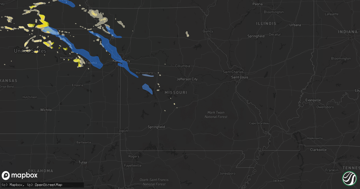
Hail Map in Missouri on June 4, 2020
Get this storm
June 4 map
$229
one time, instant access
Download today. No call, no setup
Keep the $229
Bought the map and want the full workflow? Apply the entire $229 to a subscription within 7 days. None of it is wasted.
Every map, not just this one
This buys you this map. Subscription and you get every map we run, in the markets you choose from a few cities to whole states to nationwide. Plus real-time alerts the moment a storm fires.
Contact data
Name, contact info, occupancy, even credit band for addresses in the footprint. You go from where it hit to who to call.
Become the source they trust
Unlimited branding weather history reports on demand. You already have the documented answer ready for the property owner, and you are the one who showed up with it.
Property data and RoofTrace estimates
Pull up any address you have got, its value and the exact code rules for that jurisdiction, straight from One Click Code. Then RoofTrace estimates the squares, pitch, and roof value, priced the way you price.
Storm reports in Missouri
Missouri
| Date | Description |
|---|---|
| 06/04/20207:57 AM CDT | The mesonet station mo004 on i44 at the 47 mile marker measured a 68 mph wind gust. |
| 06/04/20207:08 AM CDT | At 1207 AM CDT, a severe thunderstorm was located near Bosworth, or 10 miles east of Carrollton, moving east at 25 mph. HAZARD...60 mph wind gusts and half dollar size hail. SOURCE...Radar indicated. IMPACT...Hail damage to vehicles is expected. Expect wind damage to roofs, siding, and trees. Locations impacted include... Carrollton, Bosworth, Wakenda, Miami, Bogard and De Witt. |
| 06/04/20205:37 AM CDT | Delayed report. Picture via social media of damage to a barn and several large branches broken on a tree 6 miles southwest of stover... Mo off of highway ff. Time estim |
| 06/04/20205:30 AM CDT | Large barn collapsed... Several large trees downed off of hwy 52 and hwy w. |
| 06/04/20204:45 AM CDT | Storm spotter reported 67 mph wind gust with stationary truck mounted wind anemometer in warrensburg. |
| 06/04/20204:13 AM CDT | Estimated 60 mph winds at the nws office. |
| 06/04/20204:10 AM CDT | Nws employee reports snapped tree and estimated 60 mph gust. |
| 06/04/20204:05 AM CDT | Coop observer/spotter reported via twitter of a large tree limb... Greater than 10 inch diameter. |
| 06/04/20204:05 AM CDT | Large tree limb snapped... Laying over a fence. Time estimated from radar. |
| 06/04/20203:51 AM CDT | Kcfd reports of two large trees down damaging homes... No exact locations but one along 75th and another along 85th street. Time estimated from radar. |
| 06/04/20203:48 AM CDT | Spotter reported he measured a 72 mph wind gust in cleveland... Mo when the gust front passed through. |
| 06/04/20203:48 AM CDT | Kmbc news 9 reports via twitter of a very large tree snapped high in south kcmo. Time estimated via radar. |
| 06/04/20203:38 AM CDT | Nws employee estimated 60 mph wind gust and power outage in waldo |
| 06/04/20203:38 AM CDT | Spotter reports several tree limbs down and power outage near weatherby lake. |
| 06/04/20202:57 AM CDT | St. Joseph airport measured 64 mph wind gust. |
| 06/04/20202:23 AM CDT | Public report via twitter of numerous tree branches down in maryville and trash cans blown around streets. |
| 06/04/20201:01 AM CDT | At 601 AM CDT, severe thunderstorms were located along a line extending from 10 miles southeast of Ava to near Diamond City, moving southeast at 55 mph. HAZARD...60 mph wind gusts and penny size hail. SOURCE...Radar indicated. IMPACT...Expect damage to roofs, siding, and trees. Locations impacted include... Mountain Home... Bull Shoals... Gassville... Flippin... Lakeview in Baxter County... Arkawana... Ozark Regional Airport... Ozark Isle... Fawn Park... Bull Shoals State Park... Colfax... Lion Hill... Price Place... Cotter... Midway in Baxter County... Fairview in Marion County... Gamaliel... Oakland... Rea Valley... Peel... |
| 06/04/202012:59 AM CDT | At 559 AM CDT, a severe thunderstorm was located near Hartville, or 12 miles northwest of Mountain Grove, moving east at 35 mph. HAZARD...60 mph wind gusts. SOURCE...Radar indicated. IMPACT...Expect damage to roofs, siding, and trees. Locations impacted include... Mountain Grove... Cabool... Dawson... Norwood... Hartville... Bendavis... |
| 06/04/202012:49 AM CDT | At 548 AM CDT, severe thunderstorms were located along a line extending from 7 miles southwest of Ava to near Taneyville to near Forsyth, moving east at 50 mph. HAZARD...60 mph wind gusts. SOURCE...Radar indicated. IMPACT...Expect damage to roofs, siding, and trees. Locations impacted include... Bull Shoals Lake... Norfork Lake... Gainesville... Theodosia... Pontiac... Wasola... Sundown... Brixey... Noble... Willhoit... Brownbranch... Tecumseh... Udall... Hardenville... Thornfield... Sycamore... Dora... Rockbridge... Long Run... Isabella... |
| 06/04/202012:42 AM CDT | At 542 AM CDT, severe thunderstorms were located along a line extending from Taneyville to 6 miles southwest of Kimberling City, moving southeast at 45 mph. HAZARD...60 mph wind gusts and penny size hail. SOURCE...Radar indicated. IMPACT...Expect damage to roofs, siding, and trees. Locations impacted include... Harrison... Yellville... Flippin... Diamond City... Bergman... Western Grove... Lead Hill... Pyatt... Valley Springs... Omaha... Dugger... Olvey... Roberson Hollow... Erbie... Lakeway... Winington... Clark Hill... Lost Valley State Park... Pruitt... Myrtle... |
| 06/04/202012:40 AM CDT | At 540 AM CDT, severe thunderstorms were located along a line extending from near Seymour to near Taneyville, moving east at 50 mph. HAZARD...60 mph wind gusts. SOURCE...Radar indicated. IMPACT...Expect damage to roofs, siding, and trees. Locations impacted include... Ava... Rome... Vanzant... Squires... Brushyknob... Goodhope... Drury... Dogwood... Gentryville... |
| 06/04/202012:25 AM CDT | At 524 AM CDT, severe thunderstorms were located along a line extending from near Sparta to near Reeds Spring to 7 miles east of Cassville, moving south at 60 mph. HAZARD...70 mph wind gusts. SOURCE...Radar indicated. IMPACT...Expect considerable tree damage. Damage is likely to mobile homes, roofs, and outbuildings. Locations impacted include... Branson... Lake Taneycomo... Bull Shoals Lake... Table Rock Lake... Table Rock State Park... Hollister... Forsyth... Merriam Woods... Kissee Mills... Rockaway Beach... Bull Creek... Taneyville... Table Rock... Kirbyville... Powersite... Protem... Ridgedale... Bradleyville... Ozark Beach... Edgewater Beach... |
| 06/04/202012:18 AM CDT | At 518 AM CDT, severe thunderstorms were located along a line extending from near Crane to 9 miles west of Galena to near Cassville, moving south at 55 mph. HAZARD...70 mph wind gusts. SOURCE...Radar indicated. IMPACT...Expect considerable tree damage. Damage is likely to mobile homes, roofs, and outbuildings. Locations impacted include... Table Rock Lake... Table Rock State Park... Roaring River State Park... Silver Dollar City... Kimberling City... Shell Knob... Indian Point... Branson West... Golden... Emerald Beach... Eagle Rock... Blue Eye... Chain-O-Lakes... Arrow Point... Coney Island... Cape Fair... Jenkins... Lampe... |
| 06/04/202012:10 AM CDT | At 510 AM CDT, severe thunderstorms were located along a line extending from near Strafford to near Crane, moving east at 70 mph. HAZARD...60 mph wind gusts. SOURCE...Radar indicated. IMPACT...Expect damage to roofs, siding, and trees. Locations impacted include... Nixa... Ozark... Branson... Table Rock Lake... Clever... Merriam Woods... Sparta... Crane... Billings... Reeds Spring... Highlandville... Fremont Hills... Bull Creek... Branson West... Galena... Mccord Bend... Hurley... Spokane... Oldfield... Elkhead... |
| 06/03/202011:45 PM CDT | At 444 AM CDT, severe thunderstorms were located along a line extending from 8 miles west of Buffalo to Morrisville to near Everton, moving southeast at 60 mph. HAZARD...60 mph wind gusts. SOURCE...Radar indicated. IMPACT...Expect damage to roofs, siding, and trees. Locations impacted include... Springfield... Republic... Bolivar... Battlefield... Willard... Buffalo... Rogersville... Strafford... Ash Grove... Fair Grove... Walnut Grove... Pleasant Hope... Morrisville... Brookline... Halfway... Glidewell... Turners... March... Bois D'arc... Cave Springs...This includes Interstate 44 between mile markers 59 and 89, and nearmile marker 91. |
| 06/03/202011:38 PM CDT | At 438 AM CDT, a severe thunderstorm was located near Everton, or near Greenfield, moving southeast at 60 mph. HAZARD...60 mph wind gusts. SOURCE...Radar indicated. IMPACT...Expect damage to roofs, siding, and trees. Locations impacted include... Everton... South Greenfield... Pennsboro... |
| 06/03/202011:13 PM CDT | At 413 AM CDT, severe thunderstorms were located along a line extending from 6 miles north of Wheatland to 13 miles east of Sheldon, moving east at 45 mph. HAZARD...60 mph wind gusts and nickel size hail. SOURCE...Radar indicated. IMPACT...Expect damage to roofs, siding, and trees. Locations impacted include... Bolivar... Stockton Lake... Pomme de Terre Lake... Pomme De Terre State Park... Stockton State Park... Stockton... Pittsburg... Humansville... Polk... Fair Play... Hermitage... Weaubleau... Morrisville... Wheatland... Dadeville... Jerico Springs... Preston... Cross Timbers... Halfway... Collins... |
| 06/03/202010:21 PM CDT | At 321 AM CDT, severe thunderstorms were located along a line extending from near Clinton to near Hume to near La Harpe, moving southeast at 45 mph. HAZARD...60 mph wind gusts and quarter size hail. SOURCE...Radar indicated. IMPACT...Hail damage to vehicles is expected. Expect wind damage to roofs, siding, and trees. Locations impacted include... Truman Lake... Nevada... Fort Scott... El Dorado Springs... Appleton City... Osceola... Marmaton... Lowry City... Sheldon... Bronson... Montevallo... Uniontown... Walker... Schell City... Bronaugh... Jerico Springs... Fulton... Collins... Redfield... Roscoe...This includes Interstate 49 between mile markers 78 and 105. |
| 06/03/202010:06 PM CDT | At 304 AM CDT, severe thunderstorms were located along a line extending from near Waverly to Warrensburg to near Creighton, moving southeast at 60 mph. HAZARD...60 mph wind gusts and nickel size hail. SOURCE...Radar indicated. IMPACT...Expect damage to roofs, siding, and trees. Locations impacted include... Sedalia, Warrensburg, Marshall, Clinton, Windsor, Knob Noster, Concordia, Sweet Springs, Whiteman Air Force Base, La Monte, Pilot Grove, Smithton, Leeton, Urich, Green Ridge, Calhoun, Otterville, Deepwater, Alma and Creighton.This includes Interstate 70 in Missouri between mile markers 56 and99. |
| 06/03/202010:04 PM CDT | At 303 AM CDT, severe thunderstorms were located along a line extending from near Waverly to near Warrensburg to near Creighton, moving southeast at 60 mph. HAZARD...60 mph wind gusts and nickel size hail. SOURCE...Radar indicated. IMPACT...Expect damage to roofs, siding, and trees. Locations impacted include... Sedalia, Warrensburg, Marshall, Clinton, Windsor, Knob Noster, Concordia, Sweet Springs, Whiteman Air Force Base, La Monte, Pilot Grove, Smithton, Leeton, Urich, Green Ridge, Calhoun, Otterville, Deepwater, Creighton and Chilhowee.This includes Interstate 70 in Missouri between mile markers 57 and95. |
| 06/03/20209:55 PM CDT | At 255 AM CDT, severe thunderstorms were located along a line extending from near Garden City to near Blue Mound, moving southeast at 80 mph. HAZARD...60 mph wind gusts and nickel size hail. SOURCE...Radar indicated. IMPACT...Expect damage to roofs, siding, and trees. Locations impacted include... Butler, Adrian, Garden City, Rich Hill, Pleasanton, Mound City, Archie, Deepwater, Montrose, Hume, Blue Mound, Prescott, Amsterdam, Amoret, Rockville, Foster, Brownington, Passaic, Worland and Ballard. |
| 06/03/20209:26 PM CDT | At 226 AM CDT, severe thunderstorms were located along a line extending from near Braymer to Levasy to Peculiar, moving southeast at 45 mph. HAZARD...60 mph wind gusts and quarter size hail. SOURCE...Radar indicated. IMPACT...Hail damage to vehicles is expected. Expect wind damage to roofs, siding, and trees. Locations impacted include... Independence, Lee's Summit, Blue Springs, Grandview, Belton, Raymore, Warrensburg, Grain Valley, Harrisonville, Chillicothe, Pleasant Hill, Oak Grove, Richmond, Odessa, Greenwood, Higginsville, Lexington, Peculiar, Carrollton and Buckner.This includes the following highways... Interstate 70 in Missouri between mile markers 16 and 62. Interstate 470 between mile markers 6 and 16. |
| 06/03/20209:21 PM CDT | At 221 AM CDT, severe thunderstorms were located along a line extending from Raymore to near Lane, moving southeast at 40 mph. HAZARD...60 mph wind gusts and nickel size hail. SOURCE...Radar indicated. IMPACT...Expect damage to roofs, siding, and trees. Locations impacted include... Overland Park, Olathe, Harrisonville, Paola, Spring Hill, Peculiar, Osawatomie, Louisburg, Adrian, Edgerton, Garden City, Pleasanton, La Cygne, Mound City, Archie, Drexel, Linn Valley, Cleveland, Freeman and Parker.This includes Interstate 35 in Kansas between mile markers 204 and207. |
| 06/03/20209:14 PM CDT | At 214 AM CDT, a severe thunderstorm was located near Pattonsburg, or 10 miles northeast of Maysville, moving east at 45 mph. HAZARD...60 mph wind gusts and quarter size hail. SOURCE...Radar indicated. IMPACT...Hail damage to vehicles is expected. Expect wind damage to roofs, siding, and trees. Locations impacted include... Chillicothe, Trenton, Gallatin, Jamesport, Pattonsburg, Winston, Altamont, Jameson, Weatherby, Lock Springs, Spring Hill and Santa Rosa.This includes Interstate 35 in Missouri between mile markers 63 and75. |
| 06/03/20208:41 PM CDT | At 140 AM CDT, severe thunderstorms were located along a line extending from near Clarksdale to near Camden Point to near McLouth, moving southeast at 60 mph. HAZARD...60 mph wind gusts and nickel size hail. SOURCE...Radar indicated. IMPACT...Expect damage to roofs, siding, and trees. Locations impacted include... Kansas City, Overland Park, Olathe, Independence, St. Joseph, Shawnee, Lenexa, Leavenworth, Leawood, Liberty, Gladstone, Prairie Village, Lansing, Excelsior Springs, Merriam, Mission, Smithville, Kearney, Bonner Springs and De Soto.This includes the following highways... Interstate 70 in Missouri between mile markers 0 and 7. Interstate 70 in Kansas between mile markers 410 and 423. Interstate 35 in Missouri between mile markers 0 and 44. Interstate 35 in Kansas between mile markers 218 and 235. Interstate 29 between mile markers 0 and 47. Interstate 635 between mile markers 0 and 12. Interstate 435 between mile markers 0 and 61, and between milemarkers 79 and 83. Interstate 229 between mile markers 0 and 2. Kansas Turnpike between mile markers 209 and 226. |
All States Impacted by Hail Map on June 4, 2020
Cities Impacted by Hail Map on June 4, 2020
- Lincoln, NE
- Smith Center, KS
- Lebanon, KS
- Red Cloud, NE
- Riverton, NE
- Burr Oak, KS
- Inavale, NE
- Laverne, OK
- Claude, TX
- Duncan, OK
- Milford, IA
- Spearfish, SD
- Utica, NE
- Waco, NE
- Benedict, NE
- York, NE
- Gresham, NE
- Steamboat Rock, IA
- Silverton, TX
- Harrisonville, PA
- Gail, TX
- Fluvanna, TX
- Bladen, NE
- Ulysses, KS
- Ida Grove, IA
- Memphis, TN
- Germantown, TN
- Maryneal, TX
- Mechanicsville, IA
- Tipton, IA
- Hart, TX
- Hale Center, TX
- Olton, TX
- Plainview, TX
- Saint Onge, SD
- Whitewood, SD
- Belle Fourche, SD
- Beulah, WY
- Aladdin, WY
- Saint George, KS
- Danville, WV
- Seth, WV
- Madison, WV
- Peytona, WV
- Turtle Creek, WV
- Foster, WV
- Lubbock, TX
- Decatur, TX
- Hebron, NE
- Needmore, PA
- McConnellsburg, PA
- Fort Loudon, PA
- Mercersburg, PA
- Humboldt, IA
- Milesville, SD
- Midland, SD
- Gillette, WY
- Hendricks, MN
- Waverly, IA
- Sumner, IA
- Tripoli, IA
- Vesuvius, VA
- Raphine, VA
- Robert Lee, TX
- Stratford, IA
- Rozet, WY
- Pleasant Dale, NE
- Milford, NE
- Terril, IA
- La Porte City, IA
- Bremen, KS
- Marysville, KS
- Clifton, KS
- Palmer, KS
- Linn, KS
- Clay Center, KS
- Cordova, TN
- Liberal, KS
- Hugoton, KS
- Martin, SD
- Allen, SD
- Tuthill, SD
- Wellfleet, NE
- Warsaw, OH
- Blissfield, OH
- Walhonding, OH
- Canadian, TX
- Ruthton, MN
- Salem, NE
- Morrill, KS
- Hiawatha, KS
- Sabetha, KS
- Clarendon, TX
- Mobeetie, TX
- Miami, TX
- Hill City, SD
- Deadwood, SD
- Rapid City, SD
- Lead, SD
- Masonville, IA
- Lamont, IA
- Winthrop, IA
- Ellsworth Afb, SD
- Devils Tower, WY
- Scenic, SD
- Sturgis, SD
- Nemo, SD
- New Underwood, SD
- Piedmont, SD
- Sundance, WY
- Hermosa, SD
- Moorcroft, WY
- Wasta, SD
- Caputa, SD
- Box Elder, SD
- Black Hawk, SD
- Wanblee, SD
- Kyle, SD
- Gilmore City, IA
- Tulia, TX
- Cimarron, KS
- Dupree, SD
- Faith, SD
- Comstock, NE
- Haddam, KS
- Morrowville, KS
- Grantville, PA
- Palmyra, PA
- Annville, PA
- Harrisburg, PA
- Ratliff City, OK
- Graham, OK
- Lakefield, MN
- Windom, MN
- Bethel, PA
- Myerstown, PA
- Hulett, WY
- Lorenzo, TX
- Floydada, TX
- Ralls, TX
- Post, TX
- Reva, SD
- Prairie City, SD
- Grundy Center, IA
- Buckingham, IA
- Reinbeck, IA
- Traer, IA
- Lincoln, IA
- Morrison, IA
- Gladbrook, IA
- Wichita Falls, TX
- Alzada, MT
- Broadus, MT
- Fulda, MN
- Worthington, MN
- Brewster, MN
- Limestone, TN
- Chuckey, TN
- West Jefferson, OH
- London, OH
- Mount Sterling, OH
- Orient, OH
- Erick, OK
- Millersburg, PA
- Millerstown, PA
- Liverpool, PA
- Newport, PA
- Halifax, PA
- Duncannon, PA
- Dauphin, PA
- Seward, NE
- Clearville, PA
- Everett, PA
- Olsburg, KS
- Amanda, OH
- Lancaster, OH
- Circleville, OH
- Ashville, OH
- Stoutsville, OH
- York, PA
- Seven Valleys, PA
- Spring Grove, PA
- York New Salem, PA
- Dallastown, PA
- Luray, KS
- Fargo, OK
- Gage, OK
- Shattuck, OK
- Pocahontas, IA
- Cuba, KS
- Agenda, KS
- Saint Francis, SD
- Perryton, TX
- Kress, TX
- Heron Lake, MN
- Battle Creek, IA
- Philipsburg, PA
- Del Rio, TN
- Everest, KS
- Sargent, NE
- Broken Bow, NE
- Anselmo, NE
- Dike, IA
- Parkersburg, IA
- Valentine, NE
- Hardesty, OK
- Iowa Falls, IA
- Alden, IA
- Glasgow, VA
- Buena Vista, VA
- Natural Bridge, VA
- Natural Bridge Station, VA
- Buchanan, VA
- Montvale, VA
- Russell, MN
- Balaton, MN
- Tyler, MN
- Sayre, OK
- Temple, OK
- Waurika, OK
- Walters, OK
- Hastings, OK
- Alva, WY
- Quitaque, TX
- Lehigh, IA
- Webster City, IA
- Stanhope, IA
- Duncombe, IA
- Milford Center, OH
- Marysville, OH
- Edgemont, SD
- Wadena, IA
- Arlington, IA
- Elkader, IA
- Fayette, IA
- Strawberry Point, IA
- Volga, IA
- Loveland, OK
- Balko, OK
- Big Spring, TX
- Coahoma, TX
- Tahoka, TX
- Odonnell, TX
- Guide Rock, NE
- Superior, NE
- Hudson, IA
- Waterloo, IA
- Hartley, IA
- Melvin, IA
- Cherry Creek, SD
- Jetmore, KS
- Ingalls, KS
- Frankfort, KS
- Matador, TX
- Garvin, MN
- Jewell, KS
- Beloit, KS
- Randall, KS
- Follett, TX
- Booker, TX
- Deshler, NE
- Big Prairie, OH
- Glenmont, OH
- Killbuck, OH
- Norton, KS
- Nelson, NE
- Ruskin, NE
- Hardy, NE
- Moscow, KS
- Wheeler, TX
- Briscoe, TX
- Concordia, KS
- Scandia, KS
- Belleville, KS
- Manhattan, KS
- May, OK
- Tarkio, MO
- Letart, WV
- Aurelia, IA
- Exeter, NE
- Fairmont, NE
- McCool Junction, NE
- Mission, SD
- Hawkeye, IA
- Lebanon, MO
- Fonda, IA
- Henrietta, TX
- Atalissa, IA
- West Liberty, IA
- Waterloo, NE
- Ashland, NE
- Elkhorn, NE
- Gretna, NE
- Nocona, TX
- Osco, IL
- Cambridge, IL
- Crystal Spring, PA
- Chambersburg, PA
- Breezewood, PA
- Saint Thomas, PA
- Warfordsburg, PA
- Sugar Grove, OH
- Logan, OH
- Bremen, OH
- Guymon, OK
- Lockney, TX
- Justiceburg, TX
- Petersburg, TX
- Dimmitt, TX
- Happy, TX
- Wheatland, IA
- Blue Ridge, VA
- Vinton, VA
- Lexington, VA
- Roanoke, VA
- Belvidere, NE
- Fairbury, NE
- Reynolds, NE
- Bruning, NE
- Gilead, NE
- Strang, NE
- Chester, NE
- Ohiowa, NE
- Alexandria, NE
- Hubbell, NE
- Paw Paw, WV
- Wamego, KS
- Alma, KS
- Paxico, KS
- Webber, KS
- Mankato, KS
- Courtland, KS
- Holly Springs, MS
- Buffalo, SD
- Bison, SD
- Arnett, OK
- Sharon, OK
- Mena, AR
- Clearmont, WY
- Buffalo, WY
- Shallowater, TX
- New Deal, TX
- Nazareth, TX
- Abernathy, TX
- Jackson, MN
- Crown Point, IN
- Campbell, NE
- Upland, NE
- Blackwater, MO
- Liscomb, IA
- Marshalltown, IA
- Fort Dodge, IA
- Arthur, IA
- Crawford, OK
- Morganville, KS
- Clyde, KS
- Walker, IA
- Coggon, IA
- Glasco, KS
- Aurora, KS
- Delphos, KS
- Saint Marys, KS
- Slayton, MN
- Ord, NE
- Shelbyville, MO
- West Branch, IA
- Garden City, KS
- Sublette, KS
- Satanta, KS
- Interior, SD
- Canton, OH
- Tussy, OK
- Healdton, OK
- Flomot, TX
- Rushville, NE
- Hay Springs, NE
- Hemingford, NE
- Mahaska, KS
- Evansdale, IA
- Raymond, IA
- Du Bois, NE
- Pierceville, KS
- Potts Camp, MS
- Rulo, NE
- Craig, MO
- Raymond, NE
- Chadron, NE
- Marsland, NE
- Pine Grove, PA
- Spearman, TX
- Loraine, TX
- Okeene, OK
- Newcastle, WY
- Custer, SD
- Watson, OK
- Cove, AR
- Edgar, NE
- Hammon, OK
- Reydon, OK
- Durham, OK
- Belvue, KS
- Thedford, NE
- Ryan, OK
- Millersburg, OH
- Danville, OH
- Willow, OK
- Granite, OK
- Alex, OK
- Malcolm, NE
- Garland, NE
- Parmelee, SD
- Cement, OK
- Cyril, OK
- Fletcher, OK
- Eskridge, KS
- Maple Hill, KS
- Orrtanna, PA
- Hopewell, PA
- Bedford, PA
- Fayetteville, PA
- Home, KS
- Beattie, KS
- Mound City, MO
- Maitland, MO
- Oregon, MO
- Fillmore, MO
- Sutton, NE
- Ivanhoe, MN
- Arco, MN
- Blairsburg, IA
- Ira, TX
- Spirit Lake, IA
- Greenville, IA
- Gillett Grove, IA
- Marcus, IA
- Meriden, IA
- Cleghorn, IA
- Cherokee, IA
- Randlett, OK
- New Providence, IA
- Fort Pierre, SD
- Meadow, SD
- Hayes, SD
- Okaton, SD
- Westbrook, TX
- Colorado City, TX
- Spencer, IA
- Geneva, NE
- Panhandle, TX
- Purdum, NE
- Brownville, NE
- Falls City, NE
- Westboro, MO
- Peru, NE
- Watson, MO
- Skidmore, MO
- Fairfax, MO
- Nemaha, NE
- Rock Port, MO
- Fort Supply, OK
- Remsen, IA
- Thomson, IL
- Calamus, IA
- Eads, TN
- Palmer, IA
- Simpson, KS
- Clarence, IA
- Solon, IA
- Iowa City, IA
- Lisbon, IA
- Julian, NE
- Brock, NE
- Nebraska City, NE
- Oberlin, KS
- Jennings, KS
- Dresden, KS
- Annandale, VA
- Fairfax, VA
- Springfield, VA
- Leonardville, KS
- Riley, KS
- Smithville, OK
- Ulysses, NE
- Surprise, NE
- Stromsburg, NE
- Shelby, NE
- Osceola, NE
- Staplehurst, NE
- Rising City, NE
- Holland, MN
- Woodstock, MN
- Burwell, NE
- Thor, IA
- Alvord, TX
- Whitney, NE
- Delaware, OH
- Afton, TN
- Bellevue, TX
- Bowie, TX
- Hollenberg, KS
- Washington, KS
- Narka, KS
- Dayton, IA
- Plain City, OH
- Rosston, OK
- Gate, OK
- Westbrook, MN
- Randolph, KS
- Chattanooga, OK
- Bradgate, IA
- Rutland, IA
- Okabena, MN
- Hanover, KS
- Fairfield, NE
- Shickley, NE
- Grafton, NE
- Saronville, NE
- Henderson, NE
- Friend, NE
- Munden, KS
- Clay Center, NE
- Cordova, NE
- Osceola, AR
- Etowah, AR
- Keiser, AR
- Wilson, OK
- Ringling, OK
- Forestburg, TX
- Dows, IA
- Alliance, NE
- Hermleigh, TX
- Thomasville, PA
- Red Lion, PA
- Dawson, NE
- Nokesville, VA
- Gainesville, VA
- Bristow, VA
- Cheyenne, OK
- Coldwater, MS
- Byhalia, MS
- Hernando, MS
- Buffalo, OK
- Osceola Mills, PA
- Crawford, NE
- Saint Jo, TX
- Troy, KS
- Forest City, MO
- Wathena, KS
- Long Island, VA
- Boones Mill, VA
- Williamsburg, IA
- Brewster, NE
- Westmoreland, KS
- Sanborn, IA
- Archer, IA
- Sheldon, IA
- Primghar, IA
- Moscow, IA
- Carleton, NE
- Geary, OK
- Lindsay, OK
- Springer, OK
- Bassett, NE
- Myrtle, MS
- Hickory Flat, MS
- Roaring Springs, TX
- Alcester, SD
- Hawarden, IA
- Dolliver, IA
- Wellsburg, IA
- Topeka, KS
- Ferrum, VA
- East Moline, IL
- Bettendorf, IA
- Brainard, NE
- Hazleton, IA
- Aurora, IA
- Stanley, IA
- Independence, IA
- Amarillo, TX
- Crowell, TX
- Upton, WY
- Woodstock, OH
- North Lewisburg, OH
- Urbana, OH
- Mechanicsburg, OH
- Cable, OH
- Irwin, OH
- Dixon, IA
- Donahue, IA
- Canyon, TX
- Wilton, IA
- Muscatine, IA
- Stanberry, MO
- King City, MO
- Guilford, MO
- Rossville, TN
- Everly, IA
- Hospers, IA
- Fostoria, IA
- Orange City, IA
- Alton, IA
- Estherville, IA
- Fredericksburg, IA
- Shamrock, TX
- Berkeley Springs, WV
- Bloomery, WV
- Great Cacapon, WV
- Oketo, KS
- Camdenton, MO
- Watonga, OK
- Lexington, OK
- Dunbar, NE
- Syracuse, NE
- Southaven, MS
- Nesbit, MS
- Olive Branch, MS
- Horn Lake, MS
- Greeneville, TN
- Krum, TX
- Ponder, TX
- Zanesfield, OH
- West Liberty, OH
- Rockbridge Baths, VA
- Weinert, TX
- O'Brien, TX
- Munday, TX
- Conception Junction, MO
- Butler, OK
- Union, IA
- Norway, KS
- Jamestown, KS
- Mahaffey, PA
- Punxsutawney, PA
- Glen Campbell, PA
- Raymond, OH
- Abbottstown, PA
- Winston, MO
- West Union, IA
- Marengo, IA
- Robinson, KS
- Muenster, TX
- Currie, MN
- Alpha, MN
- Saint Joseph, MO
- Cole Camp, MO
- Hardy, VA
- Fairfield, VA
- Roberts, MT
- Absarokee, MT
- Fishtail, MT
- Manchester, MD
- Westminster, MD
- Lebanon, PA
- Ono, PA
- Richland, PA
- Womelsdorf, PA
- Fredericksburg, PA
- Jonestown, PA
- Willow Hill, PA
- Fannettsburg, PA
- Woodward, OK
- Bainbridge, OH
- Parrottsville, TN
- Hereford, TX
- Edwards, MO
- Lincoln, MO
- Warsaw, MO
- Canal Fulton, OH
- North Lawrence, OH
- Marshallville, OH
- Lake Wilson, MN
- Kenna, WV
- Ripley, WV
- Given, WV
- Jeromesville, OH
- Loudonville, OH
- Jonesborough, TN
- Beaver Crossing, NE
- Rose, OK
- Salina, OK
- Powell, OH
- Dublin, OH
- Williamstown, WV
- Vienna, WV
- Catlett, VA
- Clare, IA
- Wooster, OH
- Shreve, OH
- Chester, OK
- Rush Springs, OK
- Beaver, OK
- Dysart, IA
- Callaway, VA
- Wayside, TX
- Royal, IA
- Manson, IA
- Stoutland, MO
- Brinkhaven, OH
- Readlyn, IA
- Denver, IA
- Grand Mound, IA
- Lowden, IA
- New Liberty, IA
- Bennett, IA
- Clarence, MO
- Leonard, MO
- Merrillville, IN
- Waynesboro, PA
- Vermillion, KS
- Axtell, KS
- Lakeview, TX
- Aberdeen, SD
- Rembrandt, IA
- Alta, IA
- Storm Lake, IA
- Burnside, IA
- Wakarusa, KS
- Carbondale, KS
- Higgins, TX
- Bloomington, NE
- Kensington, KS
- Ackley, IA
- Zanesville, OH
- Byron, NE
- Leavenworth, KS
- Mount Judea, AR
- Pelsor, AR
- Groom, TX
- Merriman, NE
- Comanche, OK
- Centreville, VA
- Manassas, VA
- Blue Rapids, KS
- Waterville, KS
- Barnes, KS
- Thomas, OK
- Cozad, NE
- Tribune, KS
- Collierville, TN
- Burke, VA
- Lorton, VA
- Fairfax Station, VA
- Geneseo, IL
- Orion, IL
- Colona, IL
- Coal Valley, IL
- Horton, KS
- Indiahoma, OK
- Idalou, TX
- Springlake, TX
- Fort Belvoir, VA
- Linn Grove, IA
- Toledo, IA
- Schleswig, IA
- Danbury, IA
- Mapleton, IA
- Charter Oak, IA
- Saint Paris, OH
- Wells Tannery, PA
- Weston, NE
- Lipscomb, TX
- Big Cove Tannery, PA
- Turkey, TX
- Robinsonville, MS
- Tracy, MN
- Chandlersville, OH
- Norwich, OH
- Newport, TN
- Republic, KS
- Valparaiso, NE
- Dwight, NE
- David City, NE
- Bee, NE
- Humboldt, NE
- Atchison, KS
- Easton, KS
- Crookston, NE
- Talmage, NE
- Ireton, IA
- Sedalia, MO
- Peterson, IA
- Round Lake, MN
- Murdo, SD
- Mud Butte, SD
- Chandler, MN
- Hanover, PA
- East Berlin, PA
- Okoboji, IA
- Jewell, IA
- Mount Auburn, IA
- Albert City, IA
- Hampstead, MD
- Leedey, OK
- Astoria, SD
- Quasqueton, IA
- Rowley, IA
- Sutherland, IA
- Bradley, OK
- Lakeville, OH
- Russell, KS
- Milledgeville, GA
- Haddock, GA
- Long Lane, MO
- Byers, TX
- Faxon, OK
- Red Banks, MS
- Haskell, TX
- Ostrander, OH
- Wilmont, MN
- Leoti, KS
- Westgate, IA
- Banner, WY
- Silvis, IL
- Clifton, VA
- Woodbridge, VA
- Mosheim, TN
- Butler, OH
- Howard, OH
- Mount Vernon, OH
- Slaton, TX
- Rocky Mount, VA
- Wirtz, VA
- Lakin, KS
- Syracuse, KS
- Prague, NE
- Bruno, NE
- Mifflin, PA
- Port Royal, PA
- Avoca, TX
- Cummings, KS
- Lancaster, KS
- Effingham, KS
- Hennepin, OK
- Elmore City, OK
- Foster, OK
- Columbus, OH
- Hilliard, OH
- Aplington, IA
- Harveyville, KS
- Rossville, KS
- Custer City, OK
- Lake Park, IA
- Morning Sun, IA
- Pawnee City, NE
- Sanger, TX
- Houtzdale, PA
- Early, IA
- Nemaha, IA
- Schaller, IA
- Ninnekah, OK
- Lamesa, TX
- Wilson, TX
- San Angelo, TX
- Carlsbad, TX
- Braddock, PA
- Pittsburgh, PA
- Homestead, PA
- Hollister, OK
- Blair, OK
- Tipton, OK
- Altus, OK
- Mangum, OK
- Devol, OK
- Grandfield, OK
- Headrick, OK
- Frederick, OK
- Altus Afb, OK
- Roosevelt, OK
- Snyder, OK
- Mountain Park, OK
- Lone Wolf, OK
- Devon, PA
- Berwyn, PA
- Villanova, PA
- Wayne, PA
- Bryn Mawr, PA
- Paoli, PA
- Gladwyne, PA
- Malvern, PA
- Fort Meade, SD
- Norris, SD
- Howes, SD
- Enning, SD
- Wall, SD
- Bath, SD
- Groton, SD
- Ferney, SD
- Andover, SD
- Conde, SD
- Bristol, SD
- Redfield, SD
- Tulare, SD
- Saint Lawrence, SD
- Wessington, SD
- Wolsey, SD
- North Canton, OH
- Cody, NE
- Taylor, NE
- Bartlett, NE
- Chambers, NE
- Walton, NE
- Burr, NE
- Eagle, NE
- Douglas, NE
- Roca, NE
- Palmyra, NE
- Unadilla, NE
- Denton, NE
- Bennet, NE
- East Sparta, OH
- Bolivar, OH
- Mechanicstown, OH
- Carrollton, OH
- Salineville, OH
- Paris, OH
- Minerva, OH
- Waynesburg, OH
- East Canton, OH
- Robertsville, OH
- Navarre, OH
- East Liverpool, OH
- Irondale, OH
- New Cumberland, WV
- Chester, WV
- Wellsville, OH
- Hammondsville, OH
- Newell, WV
- Bergholz, OH
- New Albany, MS
- Blue Springs, MS
- Dunning, NE
- Malmo, NE
- Omaha, NE
- Darrouzett, TX
- Greenville, VA
- Elk City, OK
- Canute, OK
- Clinton, OK
- Foss, OK
- Dill City, OK
- Calumet, OK
- El Reno, OK
- Yukon, OK
- Weatherford, OK
- Binger, OK
- Hinton, OK
- Hydro, OK
- Minco, OK
- Florence, SD
- Webster, SD
- Stratford, SD
- Ortley, SD
- Summit, SD
- Bradley, SD
- Waubay, SD
- Marvin, SD
- Wallace, SD
- Castlewood, SD
- Clear Lake, SD
- Watertown, SD
- Hazel, SD
- Elkton, SD
- Brandt, SD
- Estelline, SD
- Toronto, SD
- White, SD
- Lake Benton, MN
- Avoca, MN
- Dovray, MN
- Wray, CO
- Eckley, CO
- Yuma, CO
- Vernon, CO
- Idalia, CO
- Saint Francis, KS
- Kirk, CO
- Burlington, CO
- Moline, IL
- Dakota City, IA
- Long Grove, IA
- Davenport, IA
- Walcott, IA
- Eldridge, IA
- Scranton, IA
- Jefferson, IA
- Churdan, IA
- Dana, IA
- Bouton, IA
- Paton, IA
- Granger, IA
- Grand Junction, IA
- Beaver, IA
- Perry, IA
- Minburn, IA
- Woodward, IA
- Ogden, IA
- Norwalk, IA
- Carlisle, IA
- Des Moines, IA
- Saint Charles, IA
- Martensdale, IA
- Prole, IA
- Indianola, IA
- Lacona, IA
- Tracy, IA
- Ackworth, IA
- Knoxville, IA
- Bussey, IA
- Columbia, IA
- Melcher Dallas, IA
- Hamilton, IA
- Pleasantville, IA
- Lovilia, IA
- Milo, IA
- Silver Lake, KS
- Grantville, KS
- Endicott, NE
- Berryton, KS
- Hoyt, KS
- Oskaloosa, KS
- Meriden, KS
- Tecumseh, KS
- Perry, KS
- Emmett, KS
- Ozawkie, KS
- Lecompton, KS
- Havensville, KS
- Delia, KS
- Lawrence, KS
- Mayetta, KS
- Onaga, KS
- Soldier, KS
- Independence, MO
- Bendena, KS
- Denton, KS
- Riverside, MO
- Dearborn, MO
- Camden Point, MO
- Leawood, KS
- Weston, MO
- Lees Summit, MO
- Holden, MO
- Greenwood, MO
- Mission, KS
- Basehor, KS
- Kansas City, MO
- Platte City, MO
- Fort Leavenworth, KS
- Rushville, MO
- Pleasant Hill, MO
- Kansas City, KS
- Overland Park, KS
- Highland, KS
- Strasburg, MO
- Lansing, KS
- Farley, MO
- Kingsville, MO
- Prairie Village, KS
- De Kalb, MO
- Waldron, MO
- Blue Springs, MO
- Stewartsville, MO
- Cosby, MO
- Easton, MO
- Clarksdale, MO
- Savannah, MO
- Amazonia, MO
- Windsor, MO
- Knob Noster, MO
- Warrensburg, MO
- Centerview, MO
- Green Ridge, MO
- Deepwater, MO
- Clinton, MO
- Calhoun, MO
- Osceola, MO
- Pomeroy, IA
- Kamrar, IA
- Williams, IA
- Hubbard, IA
- Clemons, IA
- Bancroft, IA
- Burt, IA
- Woden, IA
- Titonka, IA
- Sioux Rapids, IA
- Ayrshire, IA
- Ruthven, IA
- Dickens, IA
- Webb, IA
- Eagle Grove, IA
- West Bend, IA
- Ottosen, IA
- Mallard, IA
- Emmetsburg, IA
- Vincent, IA
- Bode, IA
- Rolfe, IA
- Cylinder, IA
- Carroll, IA
- Breda, IA
- Lidderdale, IA
- Glidden, IA
- Osceola, IA
- Murray, IA
- Vincentown, NJ
- Berlin, NJ
- Grenloch, NJ
- Voorhees, NJ
- Glassboro, NJ
- Medford, NJ
- Mullica Hill, NJ
- Williamstown, NJ
- Warwick, MD
- Stratford, NJ
- Odessa, DE
- Gibbsboro, NJ
- Townsend, DE
- Atco, NJ
- Sewell, NJ
- West Berlin, NJ
- Monroeville, NJ
- Alloway, NJ
- Blackwood, NJ
- Marlton, NJ
- Salem, NJ
- Pitman, NJ
- Bridgeton, NJ
- Woodstown, NJ
- Sicklerville, NJ
- Middletown, DE
- Clayton, NJ
- Elmer, NJ
- Clementon, NJ
- Woodbury, NJ
- Franklinville, NJ
- Chatsworth, NJ
- Egg Harbor City, NJ
- Hammonton, NJ


