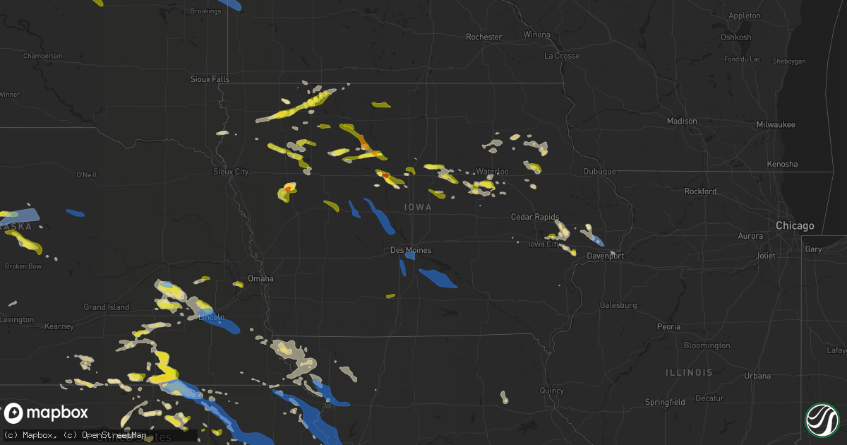
Hail Map in Iowa on June 4, 2020
Get this storm
June 4 map
$229
one time, instant access
Download today. No call, no setup
Keep the $229
Bought the map and want the full workflow? Apply the entire $229 to a subscription within 7 days. None of it is wasted.
Every map, not just this one
This buys you this map. Subscription and you get every map we run, in the markets you choose from a few cities to whole states to nationwide. Plus real-time alerts the moment a storm fires.
Contact data
Name, contact info, occupancy, even credit band for addresses in the footprint. You go from where it hit to who to call.
Become the source they trust
Unlimited branding weather history reports on demand. You already have the documented answer ready for the property owner, and you are the one who showed up with it.
Property data and RoofTrace estimates
Pull up any address you have got, its value and the exact code rules for that jurisdiction, straight from One Click Code. Then RoofTrace estimates the squares, pitch, and roof value, priced the way you price.
Storm reports in Iowa
Iowa
| Date | Description |
|---|---|
| 06/04/20206:45 PM CDT | Large tree branch down. |
| 06/04/20205:10 PM CDT | Large tree down. Bunch of dime size hail also occurred with storm. |
| 06/04/20205:07 PM CDT | A local report indicates 60 MPH wind near 1 S HUMBOLDT |
| 06/04/20204:54 PM CDT | Roof blown off cattle shed. Report via social media. Time estimated by radar. |
| 06/04/20204:50 PM CDT | Hardin county emergency management noted multiple large trees down. Power out. Time estimated from radar. |
| 06/04/20204:50 PM CDT | Large trees down. Power outages. |
| 06/04/20204:00 PM CDT | Up to 6 inch diameter tree limbs down. |
| 06/04/20204:00 PM CDT | 6 inch diameter tree limbs down in lafayette park. |
| 06/04/20203:30 PM CDT | Large tree down. Via kwwl tv viewer. Time estimated. |
| 06/04/20206:50 AM CDT | At 1150 PM CDT, a severe thunderstorm was located near Lakefield, or 7 miles west of Jackson In Jackson County, moving southeast at 35 mph. HAZARD...60 mph wind gusts and quarter size hail. SOURCE...Radar indicated. IMPACT...Hail damage to vehicles is expected. Expect wind damage to roofs, siding, and trees. This severe thunderstorm will be near... Jackson In Jackson County and Orleans around 1155 PM CDT. Superior around 1210 AM CDT.Other locations impacted by this severe thunderstorm include Alpha. |
| 06/04/20206:48 AM CDT | At 1147 PM CDT, severe thunderstorms were located along a line extending from near Greenwood to near Hickman, moving southeast at 50 mph. HAZARD...70 mph wind gusts and penny size hail. SOURCE...Trained weather spotters. There have been reports of tree damage and measured wind gusts up to 69 mph in Lincoln. IMPACT...Expect considerable tree damage. Damage is likely to mobile homes, roofs, and outbuildings. Locations impacted include... Nebraska City, Auburn, Syracuse, Weeping Water, Peru, Elmwood, Greenwood, Palmyra, Johnson, Cook, Unadilla, Avoca, Murdock, Talmage, Union, Nehawka, Douglas, Lorton, Eagle and Dunbar.This includes Interstate 80 in Nebraska between mile markers 415 and420. |
| 06/04/20206:37 AM CDT | At 1137 PM CDT, a severe thunderstorm was located over Cleghorn, or 10 miles west of Cherokee, moving east at 35 mph. HAZARD...60 mph wind gusts and half dollar size hail. SOURCE...Radar indicated. IMPACT...Hail damage to vehicles is expected. Expect wind damage to roofs, siding, and trees. This severe thunderstorm will be near... Cherokee around 1155 PM CDT. Aurelia around 1205 AM CDT.Other locations impacted by this severe thunderstorm include Meriden. |
| 06/04/20206:20 AM CDT | At 1120 PM CDT, a severe thunderstorm was located near Hartley, or 14 miles east of Sheldon, moving east at 50 mph. HAZARD...60 mph wind gusts and quarter size hail. SOURCE...Radar indicated. IMPACT...Hail damage to vehicles is expected. Expect wind damage to roofs, siding, and trees. This severe thunderstorm will be near... Hartley around 1125 PM CDT. Everly around 1135 PM CDT. Spencer In Clay County and Fostoria around 1145 PM CDT. Milford, Arnolds Park and West Okoboji around 1150 PM CDT. Terril around 1200 AM CDT.Other locations impacted by this severe thunderstorm include Moneta. |
| 06/04/20206:16 AM CDT | At 1115 PM CDT, a severe thunderstorm was located over Brewster, or near Worthington, moving southeast at 40 mph. HAZARD...60 mph wind gusts and penny size hail. SOURCE...Radar indicated. IMPACT...Expect damage to roofs, siding, and trees. This severe thunderstorm will be near... Round Lake around 1125 PM CDT. Lake Park around 1135 PM CDT.Other locations impacted by this severe thunderstorm include Kinbrae,Wilder, Dundee, Okabena and Bigelow. |
| 06/04/20205:43 AM CDT | At 1043 PM CDT, a severe thunderstorm was located 10 miles southwest of Eldora, moving east at 10 mph. HAZARD...60 mph wind gusts and half dollar size hail. SOURCE...Radar indicated. IMPACT...Hail damage to vehicles is expected. Expect wind damage to roofs, siding, and trees. Locations impacted include... Hubbard and New Providence. |
| 06/04/20205:32 AM CDT | Trained spotter reported large branches and tree downed at relatives property. Damage includes garage and power line down from tree damage. Distance from melcher-dallas |
| 06/04/20205:25 AM CDT | Spotter reported tree damage... Including large branches and downed evergreens at relatives home. Time estimated from radar. |
| 06/04/20205:11 AM CDT | At 1011 PM CDT, severe thunderstorms were located along a line extending from near Princeton to Bettendorf to Rock Island, moving southeast at 35 mph. HAZARD...60 mph wind gusts. SOURCE...Trained weather spotters. IMPACT...Expect damage to roofs, siding, and trees. Locations impacted include... Davenport, Moline, Rock Island, Bettendorf, East Moline, Silvis, Geneseo, Colona, Milan, Le Claire, Coal Valley, Hampton, Port Byron, Atkinson, Rapids City, Princeton, Annawan, Riverdale, Hooppole and Cleveland.This includes the following highways... Interstate 74 in Iowa between mile markers 2 and 5. Interstate 80 in Iowa between mile markers 299 and 306. Interstate 80 in Illinois between mile markers 1 and 35. Interstate 74 in Illinois between mile markers 1 and 19. Interstate 88 between mile markers 1 and 12. Interstate 280 between mile markers 15 and 18. |
| 06/04/20205:00 AM CDT | Des moines asos. |
| 06/04/20204:58 AM CDT | Tree branches and power lines down near se 5th street and hart avenue. Time estimated. |
| 06/04/20204:56 AM CDT | At 955 PM CDT, a severe thunderstorm was located near Walcott, or near Davenport, moving southeast at 25 mph. HAZARD...60 mph wind gusts. SOURCE...Trained weather spotters. IMPACT...Expect damage to roofs, siding, and trees. Locations impacted include... Davenport, Moline, Rock Island, Bettendorf, East Moline, Milan, Coal Valley, Walcott, Blackhawk State Park, West Lake Park, Fruitland, Rock Island Arsenal, Indian Bluff Golf Course, Mississippi Valley Fairgrounds, Moline Quad-City Airport and Credit Island.This includes the following highways... Interstate 74 in Iowa between mile markers 4 and 5. Interstate 80 in Iowa between mile markers 284 and 291. Interstate 74 in Illinois between mile markers 1 and 6. Interstate 280 between mile markers 1 and 10, and between milemarkers 14 and 18. |
| 06/04/20204:55 AM CDT | 6 to 8 inch limb down near drake. Via woi tv. Time estimated. |
| 06/04/20204:55 AM CDT | 6 inch diameter tree branch down. Time estimated. |
| 06/04/20204:54 AM CDT | A few large branches blown out of trees. Time estimated by radar. |
| 06/04/20204:50 AM CDT | Large tree branch down. Photo and report via social media. Time estimated. |
| 06/04/20204:50 AM CDT | A local report indicates 60 MPH wind near 1 WNW JOHNSTON |
| 06/04/20204:50 AM CDT | Tree snapped at based. Via who tv. Time estimated. |
| 06/04/20204:49 AM CDT | Large tree down near 63rd street and railroad avenue. Tree also brought down power line. Time estimated from radar. |
| 06/04/20204:44 AM CDT | A local report indicates 60 MPH wind near 2 ESE WAUKEE |
| 06/04/20204:42 AM CDT | Large tree... Approx. 2 feet in diameter and 60 feet tall down on edge of bike trail in polk county west des moines. Time estimated from radar. |
| 06/04/20204:39 AM CDT | Winds of at least 60 mph between 436a and 439a. |
| 06/04/20204:34 AM CDT | Estimated winds of 60 to 70mph. |
| 06/04/20204:33 AM CDT | A local report indicates 1.00 inch wind near 2 W MURRAY |
| 06/04/20204:30 AM CDT | Large tree branches down. Time estimated. |
| 06/04/20204:25 AM CDT | A local report indicates 60 MPH wind near 2 WSW MINBURN |
| 06/04/20204:20 AM CDT | Bayard fire dept reports 70+ mph wind gusts and down tree limbs. |
| 06/04/20204:20 AM CDT | Bouton fd reported large tree branches down in town. Time estimated by radar. |
| 06/04/20204:10 AM CDT | 60+ mph winds reported in bagley. |
| 06/04/20204:01 AM CDT | At 901 PM CDT, severe thunderstorms were located along a line extending from near Toronto to near Rochester, moving east at 40 mph. HAZARD...60 mph wind gusts and quarter size hail. SOURCE...Radar indicated. IMPACT...Hail damage to vehicles is expected. Expect wind damage to roofs, siding, and trees. Locations impacted include... Davenport, Bettendorf, Tipton, Eldridge, DeWitt, Camanche, Le Claire, Hampton, Walcott, Princeton, Long Grove, Lowden, Wheatland, Grand Mound, Calamus, Bennett, Riverdale, Donahue, McCausland and Low Moor.This includes the following highways... Interstate 74 in Iowa between mile markers 1 and 5. Interstate 80 in Iowa between mile markers 273 and 306. Interstate 280 between mile markers 1 and 3. |
| 06/04/20204:00 AM CDT | Report of trees and power lines down in jefferson. |
| 06/04/20203:38 AM CDT | Social media pictures showing pretty extensive tree damage on a property s of churdan. Includes what appears to be split tree and numerous other large... Healthy... Tre |
| 06/04/20203:34 AM CDT | At 833 PM CDT, a severe thunderstorm was located near Webster City, moving southeast at 25 mph. HAZARD...60 mph wind gusts and penny size hail. SOURCE...Radar indicated. IMPACT...Expect damage to roofs, siding, and trees. Locations impacted include... Webster City, Jewell Junction, Ellsworth, Stanhope, Kamrar, Brushy Creek St Recreation Area and Webster City Municipal Airport.This includes Interstate 35 between mile markers 132 and 135. |
| 06/04/20203:30 AM CDT | Williams rwis. |
| 06/04/20203:25 AM CDT | At 824 PM CDT, a severe thunderstorm was located near Big Wall Lake, or 9 miles northeast of Webster City, moving southeast at 25 mph. HAZARD...60 mph wind gusts and quarter size hail. SOURCE...Radar indicated. IMPACT...Hail damage to vehicles is expected. Expect wind damage to roofs, siding, and trees. Locations impacted include... Big Wall Lake, Alden, Williams, Blairsburg and Popejoy. This includes Interstate 35 between mile markers 136 and 155. |
| 06/04/20202:48 AM CDT | At 747 PM CDT, a severe thunderstorm was located over Fort Dodge, moving southeast at 25 mph. HAZARD...60 mph wind gusts and quarter size hail. SOURCE...Radar indicated. IMPACT...Hail damage to vehicles is expected. Expect wind damage to roofs, siding, and trees. Locations impacted include... Fort Dodge, Fort Dodge Regional Airport, Coalville, Duncombe and Brushy Creek St Recreation Area. |
| 06/04/20202:48 AM CDT | Corrects previous tstm wnd dmg report time from 3 s dakota city. Social media picture showed hail shredding young corn crop just south of humboldt/dakota city. Location |
| 06/04/20202:42 AM CDT | At 741 PM CDT, a severe thunderstorm was located near Reinbeck, or 12 miles southeast of Grundy Center, moving southeast at 25 mph. HAZARD...60 mph wind gusts and quarter size hail. SOURCE...Radar indicated. IMPACT...Hail damage to vehicles is expected. Expect wind damage to roofs, siding, and trees. Locations impacted include... Traer, Reinbeck, Dysart, Lincoln and Tf Clark State Park. |
| 06/04/20202:40 AM CDT | Social media picture showed hail shredding young corn crop just south of humboldt/dakota city. Location estimated from description and radar. Time estimated from radar. |
| 06/04/20202:40 AM CDT | Report from who-tv weather. |
| 06/04/20202:38 AM CDT | Social media picture displayed an uprooted tree west of humboldt. Time estimated from radar. |
| 06/04/20202:27 AM CDT | Small limbs also down. |
| 06/04/20202:06 AM CDT | Report from mping: quarter |
| 06/04/20202:04 AM CDT | Report via social media. Time estimated from radar. |
| 06/04/20202:02 AM CDT | Report from mping: quarter |
| 06/04/20201:59 AM CDT | Received report via nwschat from media partner... Who received the report from the public. Time estimated from radar. |
| 06/04/20201:59 AM CDT | Received report via social media... With picture showing 2.5 inch hail stone. Time estimated from radar. |
| 06/04/20201:57 AM CDT | Report via social media. Time estimated from radar. |
| 06/04/20201:56 AM CDT | At 655 PM CDT, a severe thunderstorm was located near Hawkeye, or 8 miles southwest of West Union, moving east at 20 mph. HAZARD...60 mph wind gusts and quarter size hail. SOURCE...Radar indicated. IMPACT...Hail damage to vehicles is expected. Expect wind damage to roofs, siding, and trees. This severe thunderstorm will be near... Fayette around 715 PM CDT. West Union around 720 PM CDT.Other locations impacted by this severe thunderstorm includeRandalia, Highway 93 And County W 14 and Donnan. |
| 06/04/20201:53 AM CDT | Half inch to one inch hail reported... Lasting for around 15 minutes. |
| 06/04/20201:45 AM CDT | Corrects previous tstm wnd dmg report from manchester. Part of a roof torn off a storage shed. The roof debris was blown from east to west... And also snapped a power p |
| 06/04/20201:35 AM CDT | At 634 PM CDT, severe thunderstorms were located along a line extending from near Mount Auburn to near Garrison, moving east at 25 mph. HAZARD...60 mph wind gusts and quarter size hail. SOURCE...Radar indicated. IMPACT...Hail damage to vehicles is expected. Expect wind damage to roofs, siding, and trees. Locations impacted include... Vinton, Urbana, Dysart, Shellsburg, Garrison, Mount Auburn, Vinton Memorial Airport, Rodgers Park, Benton City Park, Hoefle-Dulin Park, Spencers Grove, Benton County Fairgrounds, Minne Estema Park, Wildcat Bluff Park and Cheney.This includes Interstate 380 between mile markers 40 and 48. |
| 06/04/202012:55 AM CDT | Time estimated from radar. |
| 06/04/202012:33 AM CDT | Dime size hail with 50+mph wind gusts caused a significant amount of damage to beans and corn. Delayed report and time estimated by radar. |
| 06/04/202012:25 AM CDT | Kest estherville asos. |
| 06/04/202012:21 AM CDT | Tree branches down. Time estimated off radar. |
| 06/04/202012:21 AM CDT | Kest estherville asos. |
| 06/04/202012:09 AM CDT | Time estimated from radar. |
| 06/04/202012:04 AM CDT | At 504 PM CDT, a severe thunderstorm was located near Humboldt, or near Dakota City, moving east at 20 mph. HAZARD...60 mph wind gusts and quarter size hail. SOURCE...Radar indicated. IMPACT...Hail damage to vehicles is expected. Expect wind damage to roofs, siding, and trees. Locations impacted include... Dakota City, Humboldt, Thor, Rutland, Frank A Gotch State Park and Humboldt Municipal Airport. |
| 06/04/202012:00 AM CDT | At 500 PM CDT, a severe thunderstorm was located 7 miles southeast of Hudson, or 10 miles south of Waterloo, moving east at 15 mph. HAZARD...Ping pong ball size hail and 60 mph wind gusts. SOURCE...Radar indicated. IMPACT...People and animals outdoors will be injured. Expect hail damage to roofs, siding, windows, and vehicles. Expect wind damage to roofs, siding, and trees. Locations impacted include... La Porte City and Washburn. This includes Interstate 380 near mile marker 61. |
| 06/03/202011:57 PM CDT | Crop damage 3-4 miles east of milford. |
| 06/03/202011:55 PM CDT | A roughly 2 foot diameter tree trunk broken. |
| 06/03/202011:52 PM CDT | 2.5 ft diameter tree blocking most of county rd m49 on northwest side of big spirit lake. |
| 06/03/202011:52 PM CDT | Report via social media. |
| 06/03/202011:51 PM CDT | Quarter to golf ball sized hail reported near milford. |
| 06/03/202011:50 PM CDT | At 450 PM CDT, a severe thunderstorm was located over Pocahontas, moving east at 25 mph. HAZARD...60 mph wind gusts and quarter size hail. SOURCE...Radar indicated. IMPACT...Hail damage to vehicles is expected. Expect wind damage to roofs, siding, and trees. Locations impacted include... Pocahontas, Gilmore City and Pocahontas Municipal Airport. |
| 06/03/202011:43 PM CDT | A local report indicates 1.00 inch wind near 3 SSW CLEGHORN |
| 06/03/202011:41 PM CDT | At 441 PM CDT, a severe thunderstorm was located near Iowa Falls, moving east at 20 mph. HAZARD...60 mph wind gusts and quarter size hail. SOURCE...Radar indicated. IMPACT...Hail damage to vehicles is expected. Expect wind damage to roofs, siding, and trees. Locations impacted include... Iowa Falls and Alden. |
| 06/03/202011:34 PM CDT | At 433 PM CDT, a severe thunderstorm was located near Eldora, moving east at 20 mph. HAZARD...60 mph wind gusts and quarter size hail. SOURCE...Radar indicated. IMPACT...Hail damage to vehicles is expected. Expect wind damage to roofs, siding, and trees. Locations impacted include... Eldora, Grundy Center, Wellsburg, Steamboat Rock, Holland and Pine Lake State Park. |
| 06/03/202011:27 PM CDT | At 427 PM CDT, a severe thunderstorm was located 7 miles north of Manson, or 8 miles southeast of Pocahontas, moving east at 30 mph. HAZARD...60 mph wind gusts and quarter size hail. SOURCE...Radar indicated. IMPACT...Hail damage to vehicles is expected. Expect wind damage to roofs, siding, and trees. Locations impacted include... Palmer, Clare and Pioneer. |
| 06/03/202011:27 PM CDT | Photo of golf ball sized hail reported via social media. |
| 06/03/202011:20 PM CDT | Report via social media. |
| 06/03/202011:18 PM CDT | . |
| 06/03/202010:15 PM CDT | Torrential rainfall also reported. |
| 06/03/202010:15 PM CDT | Report of trees blown down. |
| 06/03/202010:03 PM CDT | Large tree down over the road at arlington avenue and e 15th st davenport. |
| 06/03/20209:58 PM CDT | 61 mph gust measured on asos. 45 mph sustained. |
| 06/03/20209:57 PM CDT | Tree reported down at this location. |
| 06/03/20209:50 PM CDT | Large tree branches down. Time estimated. Relayed by nws employee. |
| 06/03/20209:45 PM CDT | Estimated high wind gust. Heavy rain reported to be blowing sideways. |
| 06/03/20209:05 PM CDT | Reports of a few trees blown down across roads in town. |
| 06/03/20208:29 PM CDT | At 129 PM CDT, a severe thunderstorm was located near Troy Mills, or 12 miles southeast of Independence, and is nearly stationary. HAZARD...60 mph wind gusts and quarter size hail. SOURCE...Radar indicated. IMPACT...Hail damage to vehicles is expected. Expect wind damage to roofs, siding, and trees. Locations impacted include... Troy Mills and Robinson. |
| 06/03/20208:14 PM CDT | A local report indicates 1.75 inch wind near 1 SSW DUNCOMBE |
| 06/03/20207:42 PM CDT | Estimated 60-65 mph. Tree branches down. |
| 06/03/20207:20 PM CDT | Delayed report - some power lines and trees downed. Time estimated from radar. |
All States Impacted by Hail Map on June 4, 2020
Cities Impacted by Hail Map on June 4, 2020
- Lincoln, NE
- Smith Center, KS
- Lebanon, KS
- Red Cloud, NE
- Riverton, NE
- Burr Oak, KS
- Inavale, NE
- Laverne, OK
- Claude, TX
- Duncan, OK
- Milford, IA
- Spearfish, SD
- Utica, NE
- Waco, NE
- Benedict, NE
- York, NE
- Gresham, NE
- Steamboat Rock, IA
- Silverton, TX
- Harrisonville, PA
- Gail, TX
- Fluvanna, TX
- Bladen, NE
- Ulysses, KS
- Ida Grove, IA
- Memphis, TN
- Germantown, TN
- Maryneal, TX
- Mechanicsville, IA
- Tipton, IA
- Hart, TX
- Hale Center, TX
- Olton, TX
- Plainview, TX
- Saint Onge, SD
- Whitewood, SD
- Belle Fourche, SD
- Beulah, WY
- Aladdin, WY
- Saint George, KS
- Danville, WV
- Seth, WV
- Madison, WV
- Peytona, WV
- Turtle Creek, WV
- Foster, WV
- Lubbock, TX
- Decatur, TX
- Hebron, NE
- Needmore, PA
- McConnellsburg, PA
- Fort Loudon, PA
- Mercersburg, PA
- Humboldt, IA
- Milesville, SD
- Midland, SD
- Gillette, WY
- Hendricks, MN
- Waverly, IA
- Sumner, IA
- Tripoli, IA
- Vesuvius, VA
- Raphine, VA
- Robert Lee, TX
- Stratford, IA
- Rozet, WY
- Pleasant Dale, NE
- Milford, NE
- Terril, IA
- La Porte City, IA
- Bremen, KS
- Marysville, KS
- Clifton, KS
- Palmer, KS
- Linn, KS
- Clay Center, KS
- Cordova, TN
- Liberal, KS
- Hugoton, KS
- Martin, SD
- Allen, SD
- Tuthill, SD
- Wellfleet, NE
- Warsaw, OH
- Blissfield, OH
- Walhonding, OH
- Canadian, TX
- Ruthton, MN
- Salem, NE
- Morrill, KS
- Hiawatha, KS
- Sabetha, KS
- Clarendon, TX
- Mobeetie, TX
- Miami, TX
- Hill City, SD
- Deadwood, SD
- Rapid City, SD
- Lead, SD
- Masonville, IA
- Lamont, IA
- Winthrop, IA
- Ellsworth Afb, SD
- Devils Tower, WY
- Scenic, SD
- Sturgis, SD
- Nemo, SD
- New Underwood, SD
- Piedmont, SD
- Sundance, WY
- Hermosa, SD
- Moorcroft, WY
- Wasta, SD
- Caputa, SD
- Box Elder, SD
- Black Hawk, SD
- Wanblee, SD
- Kyle, SD
- Gilmore City, IA
- Tulia, TX
- Cimarron, KS
- Dupree, SD
- Faith, SD
- Comstock, NE
- Haddam, KS
- Morrowville, KS
- Grantville, PA
- Palmyra, PA
- Annville, PA
- Harrisburg, PA
- Ratliff City, OK
- Graham, OK
- Lakefield, MN
- Windom, MN
- Bethel, PA
- Myerstown, PA
- Hulett, WY
- Lorenzo, TX
- Floydada, TX
- Ralls, TX
- Post, TX
- Reva, SD
- Prairie City, SD
- Grundy Center, IA
- Buckingham, IA
- Reinbeck, IA
- Traer, IA
- Lincoln, IA
- Morrison, IA
- Gladbrook, IA
- Wichita Falls, TX
- Alzada, MT
- Broadus, MT
- Fulda, MN
- Worthington, MN
- Brewster, MN
- Limestone, TN
- Chuckey, TN
- West Jefferson, OH
- London, OH
- Mount Sterling, OH
- Orient, OH
- Erick, OK
- Millersburg, PA
- Millerstown, PA
- Liverpool, PA
- Newport, PA
- Halifax, PA
- Duncannon, PA
- Dauphin, PA
- Seward, NE
- Clearville, PA
- Everett, PA
- Olsburg, KS
- Amanda, OH
- Lancaster, OH
- Circleville, OH
- Ashville, OH
- Stoutsville, OH
- York, PA
- Seven Valleys, PA
- Spring Grove, PA
- York New Salem, PA
- Dallastown, PA
- Luray, KS
- Fargo, OK
- Gage, OK
- Shattuck, OK
- Pocahontas, IA
- Cuba, KS
- Agenda, KS
- Saint Francis, SD
- Perryton, TX
- Kress, TX
- Heron Lake, MN
- Battle Creek, IA
- Philipsburg, PA
- Del Rio, TN
- Everest, KS
- Sargent, NE
- Broken Bow, NE
- Anselmo, NE
- Dike, IA
- Parkersburg, IA
- Valentine, NE
- Hardesty, OK
- Iowa Falls, IA
- Alden, IA
- Glasgow, VA
- Buena Vista, VA
- Natural Bridge, VA
- Natural Bridge Station, VA
- Buchanan, VA
- Montvale, VA
- Russell, MN
- Balaton, MN
- Tyler, MN
- Sayre, OK
- Temple, OK
- Waurika, OK
- Walters, OK
- Hastings, OK
- Alva, WY
- Quitaque, TX
- Lehigh, IA
- Webster City, IA
- Stanhope, IA
- Duncombe, IA
- Milford Center, OH
- Marysville, OH
- Edgemont, SD
- Wadena, IA
- Arlington, IA
- Elkader, IA
- Fayette, IA
- Strawberry Point, IA
- Volga, IA
- Loveland, OK
- Balko, OK
- Big Spring, TX
- Coahoma, TX
- Tahoka, TX
- Odonnell, TX
- Guide Rock, NE
- Superior, NE
- Hudson, IA
- Waterloo, IA
- Hartley, IA
- Melvin, IA
- Cherry Creek, SD
- Jetmore, KS
- Ingalls, KS
- Frankfort, KS
- Matador, TX
- Garvin, MN
- Jewell, KS
- Beloit, KS
- Randall, KS
- Follett, TX
- Booker, TX
- Deshler, NE
- Big Prairie, OH
- Glenmont, OH
- Killbuck, OH
- Norton, KS
- Nelson, NE
- Ruskin, NE
- Hardy, NE
- Moscow, KS
- Wheeler, TX
- Briscoe, TX
- Concordia, KS
- Scandia, KS
- Belleville, KS
- Manhattan, KS
- May, OK
- Tarkio, MO
- Letart, WV
- Aurelia, IA
- Exeter, NE
- Fairmont, NE
- McCool Junction, NE
- Mission, SD
- Hawkeye, IA
- Lebanon, MO
- Fonda, IA
- Henrietta, TX
- Atalissa, IA
- West Liberty, IA
- Waterloo, NE
- Ashland, NE
- Elkhorn, NE
- Gretna, NE
- Nocona, TX
- Osco, IL
- Cambridge, IL
- Crystal Spring, PA
- Chambersburg, PA
- Breezewood, PA
- Saint Thomas, PA
- Warfordsburg, PA
- Sugar Grove, OH
- Logan, OH
- Bremen, OH
- Guymon, OK
- Lockney, TX
- Justiceburg, TX
- Petersburg, TX
- Dimmitt, TX
- Happy, TX
- Wheatland, IA
- Blue Ridge, VA
- Vinton, VA
- Lexington, VA
- Roanoke, VA
- Belvidere, NE
- Fairbury, NE
- Reynolds, NE
- Bruning, NE
- Gilead, NE
- Strang, NE
- Chester, NE
- Ohiowa, NE
- Alexandria, NE
- Hubbell, NE
- Paw Paw, WV
- Wamego, KS
- Alma, KS
- Paxico, KS
- Webber, KS
- Mankato, KS
- Courtland, KS
- Holly Springs, MS
- Buffalo, SD
- Bison, SD
- Arnett, OK
- Sharon, OK
- Mena, AR
- Clearmont, WY
- Buffalo, WY
- Shallowater, TX
- New Deal, TX
- Nazareth, TX
- Abernathy, TX
- Jackson, MN
- Crown Point, IN
- Campbell, NE
- Upland, NE
- Blackwater, MO
- Liscomb, IA
- Marshalltown, IA
- Fort Dodge, IA
- Arthur, IA
- Crawford, OK
- Morganville, KS
- Clyde, KS
- Walker, IA
- Coggon, IA
- Glasco, KS
- Aurora, KS
- Delphos, KS
- Saint Marys, KS
- Slayton, MN
- Ord, NE
- Shelbyville, MO
- West Branch, IA
- Garden City, KS
- Sublette, KS
- Satanta, KS
- Interior, SD
- Canton, OH
- Tussy, OK
- Healdton, OK
- Flomot, TX
- Rushville, NE
- Hay Springs, NE
- Hemingford, NE
- Mahaska, KS
- Evansdale, IA
- Raymond, IA
- Du Bois, NE
- Pierceville, KS
- Potts Camp, MS
- Rulo, NE
- Craig, MO
- Raymond, NE
- Chadron, NE
- Marsland, NE
- Pine Grove, PA
- Spearman, TX
- Loraine, TX
- Okeene, OK
- Newcastle, WY
- Custer, SD
- Watson, OK
- Cove, AR
- Edgar, NE
- Hammon, OK
- Reydon, OK
- Durham, OK
- Belvue, KS
- Thedford, NE
- Ryan, OK
- Millersburg, OH
- Danville, OH
- Willow, OK
- Granite, OK
- Alex, OK
- Malcolm, NE
- Garland, NE
- Parmelee, SD
- Cement, OK
- Cyril, OK
- Fletcher, OK
- Eskridge, KS
- Maple Hill, KS
- Orrtanna, PA
- Hopewell, PA
- Bedford, PA
- Fayetteville, PA
- Home, KS
- Beattie, KS
- Mound City, MO
- Maitland, MO
- Oregon, MO
- Fillmore, MO
- Sutton, NE
- Ivanhoe, MN
- Arco, MN
- Blairsburg, IA
- Ira, TX
- Spirit Lake, IA
- Greenville, IA
- Gillett Grove, IA
- Marcus, IA
- Meriden, IA
- Cleghorn, IA
- Cherokee, IA
- Randlett, OK
- New Providence, IA
- Fort Pierre, SD
- Meadow, SD
- Hayes, SD
- Okaton, SD
- Westbrook, TX
- Colorado City, TX
- Spencer, IA
- Geneva, NE
- Panhandle, TX
- Purdum, NE
- Brownville, NE
- Falls City, NE
- Westboro, MO
- Peru, NE
- Watson, MO
- Skidmore, MO
- Fairfax, MO
- Nemaha, NE
- Rock Port, MO
- Fort Supply, OK
- Remsen, IA
- Thomson, IL
- Calamus, IA
- Eads, TN
- Palmer, IA
- Simpson, KS
- Clarence, IA
- Solon, IA
- Iowa City, IA
- Lisbon, IA
- Julian, NE
- Brock, NE
- Nebraska City, NE
- Oberlin, KS
- Jennings, KS
- Dresden, KS
- Annandale, VA
- Fairfax, VA
- Springfield, VA
- Leonardville, KS
- Riley, KS
- Smithville, OK
- Ulysses, NE
- Surprise, NE
- Stromsburg, NE
- Shelby, NE
- Osceola, NE
- Staplehurst, NE
- Rising City, NE
- Holland, MN
- Woodstock, MN
- Burwell, NE
- Thor, IA
- Alvord, TX
- Whitney, NE
- Delaware, OH
- Afton, TN
- Bellevue, TX
- Bowie, TX
- Hollenberg, KS
- Washington, KS
- Narka, KS
- Dayton, IA
- Plain City, OH
- Rosston, OK
- Gate, OK
- Westbrook, MN
- Randolph, KS
- Chattanooga, OK
- Bradgate, IA
- Rutland, IA
- Okabena, MN
- Hanover, KS
- Fairfield, NE
- Shickley, NE
- Grafton, NE
- Saronville, NE
- Henderson, NE
- Friend, NE
- Munden, KS
- Clay Center, NE
- Cordova, NE
- Osceola, AR
- Etowah, AR
- Keiser, AR
- Wilson, OK
- Ringling, OK
- Forestburg, TX
- Dows, IA
- Alliance, NE
- Hermleigh, TX
- Thomasville, PA
- Red Lion, PA
- Dawson, NE
- Nokesville, VA
- Gainesville, VA
- Bristow, VA
- Cheyenne, OK
- Coldwater, MS
- Byhalia, MS
- Hernando, MS
- Buffalo, OK
- Osceola Mills, PA
- Crawford, NE
- Saint Jo, TX
- Troy, KS
- Forest City, MO
- Wathena, KS
- Long Island, VA
- Boones Mill, VA
- Williamsburg, IA
- Brewster, NE
- Westmoreland, KS
- Sanborn, IA
- Archer, IA
- Sheldon, IA
- Primghar, IA
- Moscow, IA
- Carleton, NE
- Geary, OK
- Lindsay, OK
- Springer, OK
- Bassett, NE
- Myrtle, MS
- Hickory Flat, MS
- Roaring Springs, TX
- Alcester, SD
- Hawarden, IA
- Dolliver, IA
- Wellsburg, IA
- Topeka, KS
- Ferrum, VA
- East Moline, IL
- Bettendorf, IA
- Brainard, NE
- Hazleton, IA
- Aurora, IA
- Stanley, IA
- Independence, IA
- Amarillo, TX
- Crowell, TX
- Upton, WY
- Woodstock, OH
- North Lewisburg, OH
- Urbana, OH
- Mechanicsburg, OH
- Cable, OH
- Irwin, OH
- Dixon, IA
- Donahue, IA
- Canyon, TX
- Wilton, IA
- Muscatine, IA
- Stanberry, MO
- King City, MO
- Guilford, MO
- Rossville, TN
- Everly, IA
- Hospers, IA
- Fostoria, IA
- Orange City, IA
- Alton, IA
- Estherville, IA
- Fredericksburg, IA
- Shamrock, TX
- Berkeley Springs, WV
- Bloomery, WV
- Great Cacapon, WV
- Oketo, KS
- Camdenton, MO
- Watonga, OK
- Lexington, OK
- Dunbar, NE
- Syracuse, NE
- Southaven, MS
- Nesbit, MS
- Olive Branch, MS
- Horn Lake, MS
- Greeneville, TN
- Krum, TX
- Ponder, TX
- Zanesfield, OH
- West Liberty, OH
- Rockbridge Baths, VA
- Weinert, TX
- O'Brien, TX
- Munday, TX
- Conception Junction, MO
- Butler, OK
- Union, IA
- Norway, KS
- Jamestown, KS
- Mahaffey, PA
- Punxsutawney, PA
- Glen Campbell, PA
- Raymond, OH
- Abbottstown, PA
- Winston, MO
- West Union, IA
- Marengo, IA
- Robinson, KS
- Muenster, TX
- Currie, MN
- Alpha, MN
- Saint Joseph, MO
- Cole Camp, MO
- Hardy, VA
- Fairfield, VA
- Roberts, MT
- Absarokee, MT
- Fishtail, MT
- Manchester, MD
- Westminster, MD
- Lebanon, PA
- Ono, PA
- Richland, PA
- Womelsdorf, PA
- Fredericksburg, PA
- Jonestown, PA
- Willow Hill, PA
- Fannettsburg, PA
- Woodward, OK
- Bainbridge, OH
- Parrottsville, TN
- Hereford, TX
- Edwards, MO
- Lincoln, MO
- Warsaw, MO
- Canal Fulton, OH
- North Lawrence, OH
- Marshallville, OH
- Lake Wilson, MN
- Kenna, WV
- Ripley, WV
- Given, WV
- Jeromesville, OH
- Loudonville, OH
- Jonesborough, TN
- Beaver Crossing, NE
- Rose, OK
- Salina, OK
- Powell, OH
- Dublin, OH
- Williamstown, WV
- Vienna, WV
- Catlett, VA
- Clare, IA
- Wooster, OH
- Shreve, OH
- Chester, OK
- Rush Springs, OK
- Beaver, OK
- Dysart, IA
- Callaway, VA
- Wayside, TX
- Royal, IA
- Manson, IA
- Stoutland, MO
- Brinkhaven, OH
- Readlyn, IA
- Denver, IA
- Grand Mound, IA
- Lowden, IA
- New Liberty, IA
- Bennett, IA
- Clarence, MO
- Leonard, MO
- Merrillville, IN
- Waynesboro, PA
- Vermillion, KS
- Axtell, KS
- Lakeview, TX
- Aberdeen, SD
- Rembrandt, IA
- Alta, IA
- Storm Lake, IA
- Burnside, IA
- Wakarusa, KS
- Carbondale, KS
- Higgins, TX
- Bloomington, NE
- Kensington, KS
- Ackley, IA
- Zanesville, OH
- Byron, NE
- Leavenworth, KS
- Mount Judea, AR
- Pelsor, AR
- Groom, TX
- Merriman, NE
- Comanche, OK
- Centreville, VA
- Manassas, VA
- Blue Rapids, KS
- Waterville, KS
- Barnes, KS
- Thomas, OK
- Cozad, NE
- Tribune, KS
- Collierville, TN
- Burke, VA
- Lorton, VA
- Fairfax Station, VA
- Geneseo, IL
- Orion, IL
- Colona, IL
- Coal Valley, IL
- Horton, KS
- Indiahoma, OK
- Idalou, TX
- Springlake, TX
- Fort Belvoir, VA
- Linn Grove, IA
- Toledo, IA
- Schleswig, IA
- Danbury, IA
- Mapleton, IA
- Charter Oak, IA
- Saint Paris, OH
- Wells Tannery, PA
- Weston, NE
- Lipscomb, TX
- Big Cove Tannery, PA
- Turkey, TX
- Robinsonville, MS
- Tracy, MN
- Chandlersville, OH
- Norwich, OH
- Newport, TN
- Republic, KS
- Valparaiso, NE
- Dwight, NE
- David City, NE
- Bee, NE
- Humboldt, NE
- Atchison, KS
- Easton, KS
- Crookston, NE
- Talmage, NE
- Ireton, IA
- Sedalia, MO
- Peterson, IA
- Round Lake, MN
- Murdo, SD
- Mud Butte, SD
- Chandler, MN
- Hanover, PA
- East Berlin, PA
- Okoboji, IA
- Jewell, IA
- Mount Auburn, IA
- Albert City, IA
- Hampstead, MD
- Leedey, OK
- Astoria, SD
- Quasqueton, IA
- Rowley, IA
- Sutherland, IA
- Bradley, OK
- Lakeville, OH
- Russell, KS
- Milledgeville, GA
- Haddock, GA
- Long Lane, MO
- Byers, TX
- Faxon, OK
- Red Banks, MS
- Haskell, TX
- Ostrander, OH
- Wilmont, MN
- Leoti, KS
- Westgate, IA
- Banner, WY
- Silvis, IL
- Clifton, VA
- Woodbridge, VA
- Mosheim, TN
- Butler, OH
- Howard, OH
- Mount Vernon, OH
- Slaton, TX
- Rocky Mount, VA
- Wirtz, VA
- Lakin, KS
- Syracuse, KS
- Prague, NE
- Bruno, NE
- Mifflin, PA
- Port Royal, PA
- Avoca, TX
- Cummings, KS
- Lancaster, KS
- Effingham, KS
- Hennepin, OK
- Elmore City, OK
- Foster, OK
- Columbus, OH
- Hilliard, OH
- Aplington, IA
- Harveyville, KS
- Rossville, KS
- Custer City, OK
- Lake Park, IA
- Morning Sun, IA
- Pawnee City, NE
- Sanger, TX
- Houtzdale, PA
- Early, IA
- Nemaha, IA
- Schaller, IA
- Ninnekah, OK
- Lamesa, TX
- Wilson, TX
- San Angelo, TX
- Carlsbad, TX
- Braddock, PA
- Pittsburgh, PA
- Homestead, PA
- Hollister, OK
- Blair, OK
- Tipton, OK
- Altus, OK
- Mangum, OK
- Devol, OK
- Grandfield, OK
- Headrick, OK
- Frederick, OK
- Altus Afb, OK
- Roosevelt, OK
- Snyder, OK
- Mountain Park, OK
- Lone Wolf, OK
- Devon, PA
- Berwyn, PA
- Villanova, PA
- Wayne, PA
- Bryn Mawr, PA
- Paoli, PA
- Gladwyne, PA
- Malvern, PA
- Fort Meade, SD
- Norris, SD
- Howes, SD
- Enning, SD
- Wall, SD
- Bath, SD
- Groton, SD
- Ferney, SD
- Andover, SD
- Conde, SD
- Bristol, SD
- Redfield, SD
- Tulare, SD
- Saint Lawrence, SD
- Wessington, SD
- Wolsey, SD
- North Canton, OH
- Cody, NE
- Taylor, NE
- Bartlett, NE
- Chambers, NE
- Walton, NE
- Burr, NE
- Eagle, NE
- Douglas, NE
- Roca, NE
- Palmyra, NE
- Unadilla, NE
- Denton, NE
- Bennet, NE
- East Sparta, OH
- Bolivar, OH
- Mechanicstown, OH
- Carrollton, OH
- Salineville, OH
- Paris, OH
- Minerva, OH
- Waynesburg, OH
- East Canton, OH
- Robertsville, OH
- Navarre, OH
- East Liverpool, OH
- Irondale, OH
- New Cumberland, WV
- Chester, WV
- Wellsville, OH
- Hammondsville, OH
- Newell, WV
- Bergholz, OH
- New Albany, MS
- Blue Springs, MS
- Dunning, NE
- Malmo, NE
- Omaha, NE
- Darrouzett, TX
- Greenville, VA
- Elk City, OK
- Canute, OK
- Clinton, OK
- Foss, OK
- Dill City, OK
- Calumet, OK
- El Reno, OK
- Yukon, OK
- Weatherford, OK
- Binger, OK
- Hinton, OK
- Hydro, OK
- Minco, OK
- Florence, SD
- Webster, SD
- Stratford, SD
- Ortley, SD
- Summit, SD
- Bradley, SD
- Waubay, SD
- Marvin, SD
- Wallace, SD
- Castlewood, SD
- Clear Lake, SD
- Watertown, SD
- Hazel, SD
- Elkton, SD
- Brandt, SD
- Estelline, SD
- Toronto, SD
- White, SD
- Lake Benton, MN
- Avoca, MN
- Dovray, MN
- Wray, CO
- Eckley, CO
- Yuma, CO
- Vernon, CO
- Idalia, CO
- Saint Francis, KS
- Kirk, CO
- Burlington, CO
- Moline, IL
- Dakota City, IA
- Long Grove, IA
- Davenport, IA
- Walcott, IA
- Eldridge, IA
- Scranton, IA
- Jefferson, IA
- Churdan, IA
- Dana, IA
- Bouton, IA
- Paton, IA
- Granger, IA
- Grand Junction, IA
- Beaver, IA
- Perry, IA
- Minburn, IA
- Woodward, IA
- Ogden, IA
- Norwalk, IA
- Carlisle, IA
- Des Moines, IA
- Saint Charles, IA
- Martensdale, IA
- Prole, IA
- Indianola, IA
- Lacona, IA
- Tracy, IA
- Ackworth, IA
- Knoxville, IA
- Bussey, IA
- Columbia, IA
- Melcher Dallas, IA
- Hamilton, IA
- Pleasantville, IA
- Lovilia, IA
- Milo, IA
- Silver Lake, KS
- Grantville, KS
- Endicott, NE
- Berryton, KS
- Hoyt, KS
- Oskaloosa, KS
- Meriden, KS
- Tecumseh, KS
- Perry, KS
- Emmett, KS
- Ozawkie, KS
- Lecompton, KS
- Havensville, KS
- Delia, KS
- Lawrence, KS
- Mayetta, KS
- Onaga, KS
- Soldier, KS
- Independence, MO
- Bendena, KS
- Denton, KS
- Riverside, MO
- Dearborn, MO
- Camden Point, MO
- Leawood, KS
- Weston, MO
- Lees Summit, MO
- Holden, MO
- Greenwood, MO
- Mission, KS
- Basehor, KS
- Kansas City, MO
- Platte City, MO
- Fort Leavenworth, KS
- Rushville, MO
- Pleasant Hill, MO
- Kansas City, KS
- Overland Park, KS
- Highland, KS
- Strasburg, MO
- Lansing, KS
- Farley, MO
- Kingsville, MO
- Prairie Village, KS
- De Kalb, MO
- Waldron, MO
- Blue Springs, MO
- Stewartsville, MO
- Cosby, MO
- Easton, MO
- Clarksdale, MO
- Savannah, MO
- Amazonia, MO
- Windsor, MO
- Knob Noster, MO
- Warrensburg, MO
- Centerview, MO
- Green Ridge, MO
- Deepwater, MO
- Clinton, MO
- Calhoun, MO
- Osceola, MO
- Pomeroy, IA
- Kamrar, IA
- Williams, IA
- Hubbard, IA
- Clemons, IA
- Bancroft, IA
- Burt, IA
- Woden, IA
- Titonka, IA
- Sioux Rapids, IA
- Ayrshire, IA
- Ruthven, IA
- Dickens, IA
- Webb, IA
- Eagle Grove, IA
- West Bend, IA
- Ottosen, IA
- Mallard, IA
- Emmetsburg, IA
- Vincent, IA
- Bode, IA
- Rolfe, IA
- Cylinder, IA
- Carroll, IA
- Breda, IA
- Lidderdale, IA
- Glidden, IA
- Osceola, IA
- Murray, IA
- Vincentown, NJ
- Berlin, NJ
- Grenloch, NJ
- Voorhees, NJ
- Glassboro, NJ
- Medford, NJ
- Mullica Hill, NJ
- Williamstown, NJ
- Warwick, MD
- Stratford, NJ
- Odessa, DE
- Gibbsboro, NJ
- Townsend, DE
- Atco, NJ
- Sewell, NJ
- West Berlin, NJ
- Monroeville, NJ
- Alloway, NJ
- Blackwood, NJ
- Marlton, NJ
- Salem, NJ
- Pitman, NJ
- Bridgeton, NJ
- Woodstown, NJ
- Sicklerville, NJ
- Middletown, DE
- Clayton, NJ
- Elmer, NJ
- Clementon, NJ
- Woodbury, NJ
- Franklinville, NJ
- Chatsworth, NJ
- Egg Harbor City, NJ
- Hammonton, NJ


