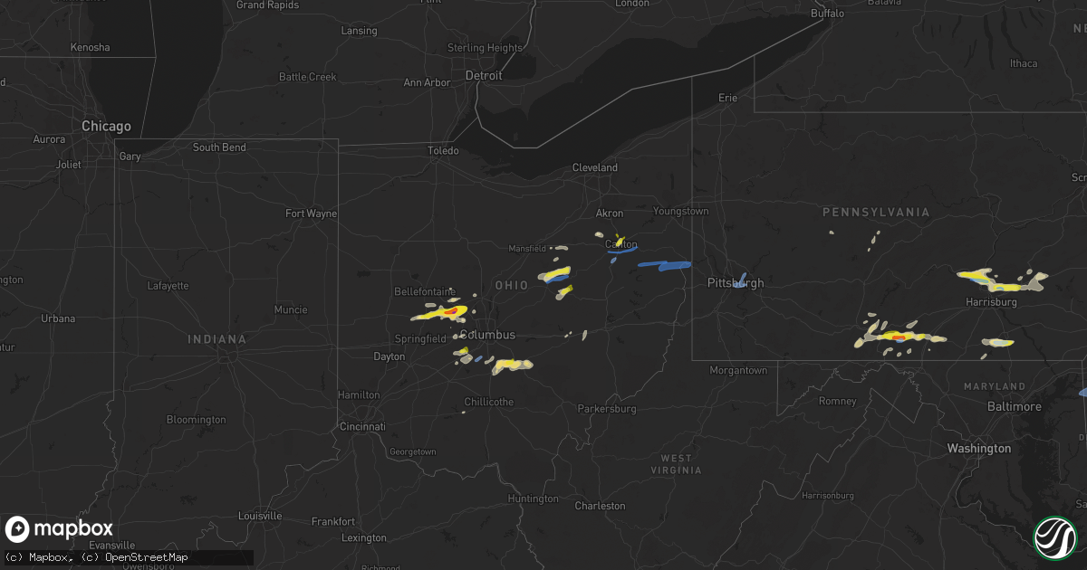
Hail Map in Ohio on June 4, 2020
Get this storm
June 4 map
$229
one time, instant access
Download today. No call, no setup
Keep the $229
Bought the map and want the full workflow? Apply the entire $229 to a subscription within 7 days. None of it is wasted.
Every map, not just this one
This buys you this map. Subscription and you get every map we run, in the markets you choose from a few cities to whole states to nationwide. Plus real-time alerts the moment a storm fires.
Contact data
Name, contact info, occupancy, even credit band for addresses in the footprint. You go from where it hit to who to call.
Become the source they trust
Unlimited branding weather history reports on demand. You already have the documented answer ready for the property owner, and you are the one who showed up with it.
Property data and RoofTrace estimates
Pull up any address you have got, its value and the exact code rules for that jurisdiction, straight from One Click Code. Then RoofTrace estimates the squares, pitch, and roof value, priced the way you price.
Storm reports in Ohio
Ohio
| Date | Description |
|---|---|
| 06/04/20202:57 PM CDT | Report of trees down along river rd in east liverpool |
| 06/04/20202:51 PM CDT | Trees down in wellsville |
| 06/04/20202:10 PM CDT | Carroll county dispatch reports multiple trees down in the county. |
| 06/04/20202:10 PM CDT | Dispatch reports trees down at state route 800 and movarian trail rd |
| 06/04/20202:07 PM CDT | Muskingum county dispatch reports trees and power lines down around the new concord area. |
| 06/04/20201:45 PM CDT | Photo posted on social media. Time estimated from person who shared. |
| 06/04/20201:42 PM CDT | Poles and wires down. |
| 06/04/20201:41 PM CDT | Barn collapsed. Photo verified. Time estimated from radar. |
| 06/04/20201:39 PM CDT | Multiple trees and power lines down around strasburg bolivar rd and ridge road |
| 06/04/20201:30 PM CDT | Quarter size hail. |
| 06/04/20201:10 PM CDT | 2-5 inch tree limbs down. Photos posted to social media. Time estimated from radar. |
| 06/04/20201:09 PM CDT | Cochocton sheriff office reports multiple trees down around the county. |
| 06/04/20201:07 PM CDT | A local report indicates 1.00 inch wind near 3 WNW MILLERSBURG |
| 06/04/20201:00 PM CDT | Several trees down along state route 62 south of state route 83 and also along county road 35. |
| 06/04/202012:58 PM CDT | Small tree limbs down across road. |
| 06/04/202012:45 PM CDT | Numerous trees down. |
| 06/04/202012:42 PM CDT | A local report indicates 1.25 inch wind near 3 NNE RINGGOLD |
| 06/04/202012:32 PM CDT | Half of a barn taken out. |
| 06/04/202012:24 PM CDT | Several reports of downed trees and power lines in south-central knox county. |
| 06/04/202012:20 PM CDT | Numerous healthy trees down near short and north road. Photo posted on social media. Time estimated from radar. |
| 06/04/202012:15 PM CDT | Telephone poles and trees reported down. Small section of a barn roof torn off. Time estimated from radar. |
| 06/04/202012:00 PM CDT | Large tree limb down. |
| 06/04/202011:28 AM CDT | A local report indicates 2.00 inch wind near 1 SE MILFORD CENTER |
| 06/04/202011:26 AM CDT | A local report indicates 1.00 inch wind near 1 S MARYSVILLE |
| 06/04/202011:26 AM CDT | A local report indicates 1.75 inch wind near S MARYSVILLE |
| 06/04/202011:19 AM CDT | A local report indicates 1.50 inch wind near MILFORD CENTER |
| 06/04/202011:19 AM CDT | Powerlines down and localized flooding. |
| 06/04/202010:44 AM CDT | A local report indicates 1.25 inch wind near 2 NNE URBANA |
| 06/04/20207:52 AM CDT | At 1251 PM EDT, a severe thunderstorm was located near Sunbury, moving east at 40 mph. HAZARD...60 mph wind gusts and quarter size hail. SOURCE...Radar indicated. IMPACT...Minor hail damage to vehicles is possible. Expect wind damage to trees and power lines. Locations impacted include... Westerville, Delaware, Powell, Johnstown, Sunbury, Utica, Ashley, Polaris, Galena, Hartford, St. Louisville, Interstate 71 at US Route 36/State Route 37, Alum Creek State Park, US Route 62 at State Route 661, Olive Green, Stratford, Purity, Center Village, Leonardsburg and Kilbourne.This includes I-71 in Ohio between mile markers 122 and 138. |
| 06/04/20207:10 AM CDT | At 1210 PM EDT, a severe thunderstorm was located near North Lewisburg, moving east at 25 mph. HAZARD...60 mph wind gusts and quarter size hail. SOURCE...Radar indicated. IMPACT...Minor hail damage to vehicles is possible. Expect wind damage to trees and power lines. Locations impacted include... Dublin, Delaware, Marysville, Powell, Plain City, Mechanicsburg, North Lewisburg, New California, Milford Center, Shawnee Hills, Ostrander, Woodstock, Magnetic Springs, Unionville Center, Rosedale, State Route 4 at State Route 161, US Route 33 at US Route 42, Warrensburg, Pottersburg and Columbus Zoo. |
| 06/04/20206:32 AM CDT | At 1132 AM EDT, a severe thunderstorm was located near Urbana, moving northeast at 25 mph. HAZARD...60 mph wind gusts and quarter size hail. SOURCE...Radar indicated. IMPACT...Minor hail damage to vehicles is possible. Expect wind damage to trees and power lines. Locations impacted include... Marysville, Urbana, West Liberty, North Lewisburg, Milford Center, Woodstock, Cable, Raymond, Westville, Pickrelltown, Lippincott, Broadway, Middleburg, State Route 4 at State Route 161, Mingo, Pottersburg, Kennard and East Liberty. |
| 06/03/202011:16 PM CDT | At 415 PM EDT, a severe thunderstorm was located near Campbell, or 8 miles west of New Castle, moving east at 15 mph. HAZARD...Wind gusts to 60 mph. SOURCE...Radar. IMPACT...Expect damage to trees and power lines, resulting in some power outages. Locations impacted include... New Castle... Hermitage... Sharon... Grove City... Franklin... Sharpsville... Sugarcreek... Farrell... Slippery Rock... New Wilmington... Oakwood... New Castle Northwest...This includes the following highways... Interstate 79 in Pennsylvania between mile markers 104 and 132. Interstate 80 in Pennsylvania between mile markers 0 and 38. Interstate 376 in Pennsylvania between mile markers 4 and 14. |
| 06/03/20209:49 PM CDT | At 248 PM EDT, a severe thunderstorm was located over North Zanesville, or near Zanesville, moving northeast at 45 mph. HAZARD...Wind gusts to 60 mph and quarter-size hail. SOURCE...Radar. IMPACT...Minor hail damage to vehicles is possible. Expect wind damage to trees and power lines, resulting in some power outages. Locations impacted include... Zanesville... Coshocton... Cambridge... Newcomerstown... New Concord... Byesville... West Lafayette... South Zanesville... North Zanesville... Dresden... Antrim... Philo...This includes the following highways... Interstate 70 in Ohio between mile markers 152 and 192. Interstate 77 in Ohio between mile markers 41 and 67. |
| 06/03/20209:24 PM CDT | At 224 PM EDT, a severe thunderstorm was located near Doylestown, or 14 miles southwest of Akron, moving east at 20 mph. HAZARD...Ping pong ball size hail and 60 mph wind gusts. SOURCE...Radar indicated. IMPACT...People and animals outdoors will be injured. Expect hail damage to roofs, siding, windows, and vehicles. Expect damage to trees and power lines. Locations impacted include... Canton, Massillon, Barberton, Green, Alliance, North Canton, Louisville, Minerva, Doylestown, Hartville, Brewster, Navarre, Dalton, Waynesburg, East Sparta, Wilmot, New Franklin, Canal Fulton, East Canton and Clinton. |
| 06/03/20209:18 PM CDT | At 217 PM EDT, severe thunderstorms were located along a line extending from near Holmesville to 7 miles north of Coshocton, moving east at 35 mph. HAZARD...Wind gusts to 60 mph. SOURCE...Radar. IMPACT...Expect damage to trees and power lines, resulting in some power outages. Locations impacted include... New Philadelphia... Dover... Uhrichsville... Carrollton... Minerva... Dennison... Strasburg... Sugarcreek... Gnadenhutten... Malvern... Tuscarawas... Bolivar...This includes Interstate 77 in Ohio between mile markers 68 and 94. |
| 06/03/20208:54 PM CDT | At 154 PM EDT, a severe thunderstorm was located 8 miles west of Lancaster, moving northeast at 20 mph. HAZARD...60 mph wind gusts and quarter size hail. SOURCE...Radar indicated. IMPACT...Minor hail damage to vehicles is possible. Expect wind damage to trees and power lines. Locations impacted include... Lancaster, Baltimore, Buckeye Lake, Millersport, Pleasantville, Fairfield Beach, Royalton, Lithopolis, Amanda, Thurston, Carroll, Rushville, West Rushville, Fairfield County Airport, US Route 22 at State Route 159, State Route 158 at State Route 204, Dumontville and North Berne. |
| 06/03/20208:52 PM CDT | At 152 PM EDT, a severe thunderstorm was located over Glenmont, or 7 miles west of Millersburg, moving northeast at 25 mph. HAZARD...Two inch hail and 60 mph wind gusts. SOURCE...Radar indicated. IMPACT...People and animals outdoors will be injured. Expect hail damage to roofs, siding, windows, and vehicles. Expect damage to trees and power lines. Locations impacted include... Millersburg, Berlin, Walnut Creek, Sugarcreek, Dalton, Shreve, Killbuck, Holmesville, Glenmont, Mount Eaton, Nashville, Winesburg, Farmerstown, Apple Creek, Baltic, Fredericksburg, Mount Hope and Charm. |
| 06/03/20208:44 PM CDT | At 143 PM EDT, a severe thunderstorm was located near Grove City, moving east at 25 mph. HAZARD...60 mph wind gusts and quarter size hail. SOURCE...Radar indicated. IMPACT...Minor hail damage to vehicles is possible. Expect wind damage to trees and power lines. Locations impacted include... Columbus, Reynoldsburg, Grove City, Canal Winchester, Groveport, Ashville, South Bloomfield, Whitehall, Obetz, Commercial Point, Lithopolis, Urbancrest, Harrisburg, Orient, Lockbourne, Darbyville, Brice, Derby, Blacklick Estates and Duvall.This includes the following Interstates... I-70 in Ohio between mile markers 105 and 111. I-71 in Ohio between mile markers 88 and 103. |
| 06/03/20208:41 PM CDT | At 140 PM EDT, a severe thunderstorm was located 10 miles southeast of Gambier, or 14 miles southeast of Mount Vernon, moving northeast at 30 mph. HAZARD...Wind gusts to 60 mph and quarter-size hail. SOURCE...Radar. IMPACT...Minor hail damage to vehicles is possible. Expect wind damage to trees and power lines, resulting in some power outages. Locations impacted include... Warsaw... Nellie... Chili... Walhonding... Layland... Blissfield... New Guilford... |
| 06/03/20208:29 PM CDT | At 128 PM EDT, a severe thunderstorm was located near Danville, or 14 miles northeast of Mount Vernon, moving northeast at 20 mph. HAZARD...60 mph wind gusts and quarter size hail. SOURCE...Radar indicated. IMPACT...Minor damage to vehicles is possible. Expect damage to trees and power lines. Locations impacted include... Loudonville, Shreve, Danville, Hayesville, Holmesville, Glenmont, Nashville, Butler, Perrysville, Jeromesville, Fredericksburg, Gann, North Liberty and Mohicanville. |
| 06/03/20208:08 PM CDT | At 108 PM EDT, severe thunderstorms were located along a line extending from near Jefferson to 8 miles south of London, moving east at 35 mph. HAZARD...60 mph wind gusts and quarter size hail. SOURCE...Radar indicated. IMPACT...Minor hail damage to vehicles is possible. Expect wind damage to trees and power lines. Locations impacted include... Columbus, Grove City, Gahanna, Bexley, London, Jefferson, West Jefferson, Lake Darby, Whitehall, Grandview Heights, Commercial Point, Urbancrest, Valleyview, Marble Cliff, Harrisburg, Orient, Port Columbus Airport, Georgesville, Madison Lake and Darbydale.This includes the following Interstates... I-70 in Ohio between mile markers 93 and 104. I-71 in Ohio between mile markers 86 and 111. |
| 06/03/20208:04 PM CDT | At 103 PM EDT, a severe thunderstorm was located over Sparta, or 11 miles southeast of Mount Gilead, moving east at 40 mph. HAZARD...60 mph wind gusts and quarter size hail. SOURCE...Radar indicated. IMPACT...Minor damage to vehicles is possible. Expect damage to trees and power lines. Locations impacted include... Mount Vernon, Fredericktown, Gambier, Utica, Centerburg, Danville, Chesterville, Sparta, Waterford, Marengo, Fulton, Martinsburg, Gann, North Liberty and Bladensburg. |
All States Impacted by Hail Map on June 4, 2020
Cities Impacted by Hail Map on June 4, 2020
- Lincoln, NE
- Smith Center, KS
- Lebanon, KS
- Red Cloud, NE
- Riverton, NE
- Burr Oak, KS
- Inavale, NE
- Laverne, OK
- Claude, TX
- Duncan, OK
- Milford, IA
- Spearfish, SD
- Utica, NE
- Waco, NE
- Benedict, NE
- York, NE
- Gresham, NE
- Steamboat Rock, IA
- Silverton, TX
- Harrisonville, PA
- Gail, TX
- Fluvanna, TX
- Bladen, NE
- Ulysses, KS
- Ida Grove, IA
- Memphis, TN
- Germantown, TN
- Maryneal, TX
- Mechanicsville, IA
- Tipton, IA
- Hart, TX
- Hale Center, TX
- Olton, TX
- Plainview, TX
- Saint Onge, SD
- Whitewood, SD
- Belle Fourche, SD
- Beulah, WY
- Aladdin, WY
- Saint George, KS
- Danville, WV
- Seth, WV
- Madison, WV
- Peytona, WV
- Turtle Creek, WV
- Foster, WV
- Lubbock, TX
- Decatur, TX
- Hebron, NE
- Needmore, PA
- McConnellsburg, PA
- Fort Loudon, PA
- Mercersburg, PA
- Humboldt, IA
- Milesville, SD
- Midland, SD
- Gillette, WY
- Hendricks, MN
- Waverly, IA
- Sumner, IA
- Tripoli, IA
- Vesuvius, VA
- Raphine, VA
- Robert Lee, TX
- Stratford, IA
- Rozet, WY
- Pleasant Dale, NE
- Milford, NE
- Terril, IA
- La Porte City, IA
- Bremen, KS
- Marysville, KS
- Clifton, KS
- Palmer, KS
- Linn, KS
- Clay Center, KS
- Cordova, TN
- Liberal, KS
- Hugoton, KS
- Martin, SD
- Allen, SD
- Tuthill, SD
- Wellfleet, NE
- Warsaw, OH
- Blissfield, OH
- Walhonding, OH
- Canadian, TX
- Ruthton, MN
- Salem, NE
- Morrill, KS
- Hiawatha, KS
- Sabetha, KS
- Clarendon, TX
- Mobeetie, TX
- Miami, TX
- Hill City, SD
- Deadwood, SD
- Rapid City, SD
- Lead, SD
- Masonville, IA
- Lamont, IA
- Winthrop, IA
- Ellsworth Afb, SD
- Devils Tower, WY
- Scenic, SD
- Sturgis, SD
- Nemo, SD
- New Underwood, SD
- Piedmont, SD
- Sundance, WY
- Hermosa, SD
- Moorcroft, WY
- Wasta, SD
- Caputa, SD
- Box Elder, SD
- Black Hawk, SD
- Wanblee, SD
- Kyle, SD
- Gilmore City, IA
- Tulia, TX
- Cimarron, KS
- Dupree, SD
- Faith, SD
- Comstock, NE
- Haddam, KS
- Morrowville, KS
- Grantville, PA
- Palmyra, PA
- Annville, PA
- Harrisburg, PA
- Ratliff City, OK
- Graham, OK
- Lakefield, MN
- Windom, MN
- Bethel, PA
- Myerstown, PA
- Hulett, WY
- Lorenzo, TX
- Floydada, TX
- Ralls, TX
- Post, TX
- Reva, SD
- Prairie City, SD
- Grundy Center, IA
- Buckingham, IA
- Reinbeck, IA
- Traer, IA
- Lincoln, IA
- Morrison, IA
- Gladbrook, IA
- Wichita Falls, TX
- Alzada, MT
- Broadus, MT
- Fulda, MN
- Worthington, MN
- Brewster, MN
- Limestone, TN
- Chuckey, TN
- West Jefferson, OH
- London, OH
- Mount Sterling, OH
- Orient, OH
- Erick, OK
- Millersburg, PA
- Millerstown, PA
- Liverpool, PA
- Newport, PA
- Halifax, PA
- Duncannon, PA
- Dauphin, PA
- Seward, NE
- Clearville, PA
- Everett, PA
- Olsburg, KS
- Amanda, OH
- Lancaster, OH
- Circleville, OH
- Ashville, OH
- Stoutsville, OH
- York, PA
- Seven Valleys, PA
- Spring Grove, PA
- York New Salem, PA
- Dallastown, PA
- Luray, KS
- Fargo, OK
- Gage, OK
- Shattuck, OK
- Pocahontas, IA
- Cuba, KS
- Agenda, KS
- Saint Francis, SD
- Perryton, TX
- Kress, TX
- Heron Lake, MN
- Battle Creek, IA
- Philipsburg, PA
- Del Rio, TN
- Everest, KS
- Sargent, NE
- Broken Bow, NE
- Anselmo, NE
- Dike, IA
- Parkersburg, IA
- Valentine, NE
- Hardesty, OK
- Iowa Falls, IA
- Alden, IA
- Glasgow, VA
- Buena Vista, VA
- Natural Bridge, VA
- Natural Bridge Station, VA
- Buchanan, VA
- Montvale, VA
- Russell, MN
- Balaton, MN
- Tyler, MN
- Sayre, OK
- Temple, OK
- Waurika, OK
- Walters, OK
- Hastings, OK
- Alva, WY
- Quitaque, TX
- Lehigh, IA
- Webster City, IA
- Stanhope, IA
- Duncombe, IA
- Milford Center, OH
- Marysville, OH
- Edgemont, SD
- Wadena, IA
- Arlington, IA
- Elkader, IA
- Fayette, IA
- Strawberry Point, IA
- Volga, IA
- Loveland, OK
- Balko, OK
- Big Spring, TX
- Coahoma, TX
- Tahoka, TX
- Odonnell, TX
- Guide Rock, NE
- Superior, NE
- Hudson, IA
- Waterloo, IA
- Hartley, IA
- Melvin, IA
- Cherry Creek, SD
- Jetmore, KS
- Ingalls, KS
- Frankfort, KS
- Matador, TX
- Garvin, MN
- Jewell, KS
- Beloit, KS
- Randall, KS
- Follett, TX
- Booker, TX
- Deshler, NE
- Big Prairie, OH
- Glenmont, OH
- Killbuck, OH
- Norton, KS
- Nelson, NE
- Ruskin, NE
- Hardy, NE
- Moscow, KS
- Wheeler, TX
- Briscoe, TX
- Concordia, KS
- Scandia, KS
- Belleville, KS
- Manhattan, KS
- May, OK
- Tarkio, MO
- Letart, WV
- Aurelia, IA
- Exeter, NE
- Fairmont, NE
- McCool Junction, NE
- Mission, SD
- Hawkeye, IA
- Lebanon, MO
- Fonda, IA
- Henrietta, TX
- Atalissa, IA
- West Liberty, IA
- Waterloo, NE
- Ashland, NE
- Elkhorn, NE
- Gretna, NE
- Nocona, TX
- Osco, IL
- Cambridge, IL
- Crystal Spring, PA
- Chambersburg, PA
- Breezewood, PA
- Saint Thomas, PA
- Warfordsburg, PA
- Sugar Grove, OH
- Logan, OH
- Bremen, OH
- Guymon, OK
- Lockney, TX
- Justiceburg, TX
- Petersburg, TX
- Dimmitt, TX
- Happy, TX
- Wheatland, IA
- Blue Ridge, VA
- Vinton, VA
- Lexington, VA
- Roanoke, VA
- Belvidere, NE
- Fairbury, NE
- Reynolds, NE
- Bruning, NE
- Gilead, NE
- Strang, NE
- Chester, NE
- Ohiowa, NE
- Alexandria, NE
- Hubbell, NE
- Paw Paw, WV
- Wamego, KS
- Alma, KS
- Paxico, KS
- Webber, KS
- Mankato, KS
- Courtland, KS
- Holly Springs, MS
- Buffalo, SD
- Bison, SD
- Arnett, OK
- Sharon, OK
- Mena, AR
- Clearmont, WY
- Buffalo, WY
- Shallowater, TX
- New Deal, TX
- Nazareth, TX
- Abernathy, TX
- Jackson, MN
- Crown Point, IN
- Campbell, NE
- Upland, NE
- Blackwater, MO
- Liscomb, IA
- Marshalltown, IA
- Fort Dodge, IA
- Arthur, IA
- Crawford, OK
- Morganville, KS
- Clyde, KS
- Walker, IA
- Coggon, IA
- Glasco, KS
- Aurora, KS
- Delphos, KS
- Saint Marys, KS
- Slayton, MN
- Ord, NE
- Shelbyville, MO
- West Branch, IA
- Garden City, KS
- Sublette, KS
- Satanta, KS
- Interior, SD
- Canton, OH
- Tussy, OK
- Healdton, OK
- Flomot, TX
- Rushville, NE
- Hay Springs, NE
- Hemingford, NE
- Mahaska, KS
- Evansdale, IA
- Raymond, IA
- Du Bois, NE
- Pierceville, KS
- Potts Camp, MS
- Rulo, NE
- Craig, MO
- Raymond, NE
- Chadron, NE
- Marsland, NE
- Pine Grove, PA
- Spearman, TX
- Loraine, TX
- Okeene, OK
- Newcastle, WY
- Custer, SD
- Watson, OK
- Cove, AR
- Edgar, NE
- Hammon, OK
- Reydon, OK
- Durham, OK
- Belvue, KS
- Thedford, NE
- Ryan, OK
- Millersburg, OH
- Danville, OH
- Willow, OK
- Granite, OK
- Alex, OK
- Malcolm, NE
- Garland, NE
- Parmelee, SD
- Cement, OK
- Cyril, OK
- Fletcher, OK
- Eskridge, KS
- Maple Hill, KS
- Orrtanna, PA
- Hopewell, PA
- Bedford, PA
- Fayetteville, PA
- Home, KS
- Beattie, KS
- Mound City, MO
- Maitland, MO
- Oregon, MO
- Fillmore, MO
- Sutton, NE
- Ivanhoe, MN
- Arco, MN
- Blairsburg, IA
- Ira, TX
- Spirit Lake, IA
- Greenville, IA
- Gillett Grove, IA
- Marcus, IA
- Meriden, IA
- Cleghorn, IA
- Cherokee, IA
- Randlett, OK
- New Providence, IA
- Fort Pierre, SD
- Meadow, SD
- Hayes, SD
- Okaton, SD
- Westbrook, TX
- Colorado City, TX
- Spencer, IA
- Geneva, NE
- Panhandle, TX
- Purdum, NE
- Brownville, NE
- Falls City, NE
- Westboro, MO
- Peru, NE
- Watson, MO
- Skidmore, MO
- Fairfax, MO
- Nemaha, NE
- Rock Port, MO
- Fort Supply, OK
- Remsen, IA
- Thomson, IL
- Calamus, IA
- Eads, TN
- Palmer, IA
- Simpson, KS
- Clarence, IA
- Solon, IA
- Iowa City, IA
- Lisbon, IA
- Julian, NE
- Brock, NE
- Nebraska City, NE
- Oberlin, KS
- Jennings, KS
- Dresden, KS
- Annandale, VA
- Fairfax, VA
- Springfield, VA
- Leonardville, KS
- Riley, KS
- Smithville, OK
- Ulysses, NE
- Surprise, NE
- Stromsburg, NE
- Shelby, NE
- Osceola, NE
- Staplehurst, NE
- Rising City, NE
- Holland, MN
- Woodstock, MN
- Burwell, NE
- Thor, IA
- Alvord, TX
- Whitney, NE
- Delaware, OH
- Afton, TN
- Bellevue, TX
- Bowie, TX
- Hollenberg, KS
- Washington, KS
- Narka, KS
- Dayton, IA
- Plain City, OH
- Rosston, OK
- Gate, OK
- Westbrook, MN
- Randolph, KS
- Chattanooga, OK
- Bradgate, IA
- Rutland, IA
- Okabena, MN
- Hanover, KS
- Fairfield, NE
- Shickley, NE
- Grafton, NE
- Saronville, NE
- Henderson, NE
- Friend, NE
- Munden, KS
- Clay Center, NE
- Cordova, NE
- Osceola, AR
- Etowah, AR
- Keiser, AR
- Wilson, OK
- Ringling, OK
- Forestburg, TX
- Dows, IA
- Alliance, NE
- Hermleigh, TX
- Thomasville, PA
- Red Lion, PA
- Dawson, NE
- Nokesville, VA
- Gainesville, VA
- Bristow, VA
- Cheyenne, OK
- Coldwater, MS
- Byhalia, MS
- Hernando, MS
- Buffalo, OK
- Osceola Mills, PA
- Crawford, NE
- Saint Jo, TX
- Troy, KS
- Forest City, MO
- Wathena, KS
- Long Island, VA
- Boones Mill, VA
- Williamsburg, IA
- Brewster, NE
- Westmoreland, KS
- Sanborn, IA
- Archer, IA
- Sheldon, IA
- Primghar, IA
- Moscow, IA
- Carleton, NE
- Geary, OK
- Lindsay, OK
- Springer, OK
- Bassett, NE
- Myrtle, MS
- Hickory Flat, MS
- Roaring Springs, TX
- Alcester, SD
- Hawarden, IA
- Dolliver, IA
- Wellsburg, IA
- Topeka, KS
- Ferrum, VA
- East Moline, IL
- Bettendorf, IA
- Brainard, NE
- Hazleton, IA
- Aurora, IA
- Stanley, IA
- Independence, IA
- Amarillo, TX
- Crowell, TX
- Upton, WY
- Woodstock, OH
- North Lewisburg, OH
- Urbana, OH
- Mechanicsburg, OH
- Cable, OH
- Irwin, OH
- Dixon, IA
- Donahue, IA
- Canyon, TX
- Wilton, IA
- Muscatine, IA
- Stanberry, MO
- King City, MO
- Guilford, MO
- Rossville, TN
- Everly, IA
- Hospers, IA
- Fostoria, IA
- Orange City, IA
- Alton, IA
- Estherville, IA
- Fredericksburg, IA
- Shamrock, TX
- Berkeley Springs, WV
- Bloomery, WV
- Great Cacapon, WV
- Oketo, KS
- Camdenton, MO
- Watonga, OK
- Lexington, OK
- Dunbar, NE
- Syracuse, NE
- Southaven, MS
- Nesbit, MS
- Olive Branch, MS
- Horn Lake, MS
- Greeneville, TN
- Krum, TX
- Ponder, TX
- Zanesfield, OH
- West Liberty, OH
- Rockbridge Baths, VA
- Weinert, TX
- O'Brien, TX
- Munday, TX
- Conception Junction, MO
- Butler, OK
- Union, IA
- Norway, KS
- Jamestown, KS
- Mahaffey, PA
- Punxsutawney, PA
- Glen Campbell, PA
- Raymond, OH
- Abbottstown, PA
- Winston, MO
- West Union, IA
- Marengo, IA
- Robinson, KS
- Muenster, TX
- Currie, MN
- Alpha, MN
- Saint Joseph, MO
- Cole Camp, MO
- Hardy, VA
- Fairfield, VA
- Roberts, MT
- Absarokee, MT
- Fishtail, MT
- Manchester, MD
- Westminster, MD
- Lebanon, PA
- Ono, PA
- Richland, PA
- Womelsdorf, PA
- Fredericksburg, PA
- Jonestown, PA
- Willow Hill, PA
- Fannettsburg, PA
- Woodward, OK
- Bainbridge, OH
- Parrottsville, TN
- Hereford, TX
- Edwards, MO
- Lincoln, MO
- Warsaw, MO
- Canal Fulton, OH
- North Lawrence, OH
- Marshallville, OH
- Lake Wilson, MN
- Kenna, WV
- Ripley, WV
- Given, WV
- Jeromesville, OH
- Loudonville, OH
- Jonesborough, TN
- Beaver Crossing, NE
- Rose, OK
- Salina, OK
- Powell, OH
- Dublin, OH
- Williamstown, WV
- Vienna, WV
- Catlett, VA
- Clare, IA
- Wooster, OH
- Shreve, OH
- Chester, OK
- Rush Springs, OK
- Beaver, OK
- Dysart, IA
- Callaway, VA
- Wayside, TX
- Royal, IA
- Manson, IA
- Stoutland, MO
- Brinkhaven, OH
- Readlyn, IA
- Denver, IA
- Grand Mound, IA
- Lowden, IA
- New Liberty, IA
- Bennett, IA
- Clarence, MO
- Leonard, MO
- Merrillville, IN
- Waynesboro, PA
- Vermillion, KS
- Axtell, KS
- Lakeview, TX
- Aberdeen, SD
- Rembrandt, IA
- Alta, IA
- Storm Lake, IA
- Burnside, IA
- Wakarusa, KS
- Carbondale, KS
- Higgins, TX
- Bloomington, NE
- Kensington, KS
- Ackley, IA
- Zanesville, OH
- Byron, NE
- Leavenworth, KS
- Mount Judea, AR
- Pelsor, AR
- Groom, TX
- Merriman, NE
- Comanche, OK
- Centreville, VA
- Manassas, VA
- Blue Rapids, KS
- Waterville, KS
- Barnes, KS
- Thomas, OK
- Cozad, NE
- Tribune, KS
- Collierville, TN
- Burke, VA
- Lorton, VA
- Fairfax Station, VA
- Geneseo, IL
- Orion, IL
- Colona, IL
- Coal Valley, IL
- Horton, KS
- Indiahoma, OK
- Idalou, TX
- Springlake, TX
- Fort Belvoir, VA
- Linn Grove, IA
- Toledo, IA
- Schleswig, IA
- Danbury, IA
- Mapleton, IA
- Charter Oak, IA
- Saint Paris, OH
- Wells Tannery, PA
- Weston, NE
- Lipscomb, TX
- Big Cove Tannery, PA
- Turkey, TX
- Robinsonville, MS
- Tracy, MN
- Chandlersville, OH
- Norwich, OH
- Newport, TN
- Republic, KS
- Valparaiso, NE
- Dwight, NE
- David City, NE
- Bee, NE
- Humboldt, NE
- Atchison, KS
- Easton, KS
- Crookston, NE
- Talmage, NE
- Ireton, IA
- Sedalia, MO
- Peterson, IA
- Round Lake, MN
- Murdo, SD
- Mud Butte, SD
- Chandler, MN
- Hanover, PA
- East Berlin, PA
- Okoboji, IA
- Jewell, IA
- Mount Auburn, IA
- Albert City, IA
- Hampstead, MD
- Leedey, OK
- Astoria, SD
- Quasqueton, IA
- Rowley, IA
- Sutherland, IA
- Bradley, OK
- Lakeville, OH
- Russell, KS
- Milledgeville, GA
- Haddock, GA
- Long Lane, MO
- Byers, TX
- Faxon, OK
- Red Banks, MS
- Haskell, TX
- Ostrander, OH
- Wilmont, MN
- Leoti, KS
- Westgate, IA
- Banner, WY
- Silvis, IL
- Clifton, VA
- Woodbridge, VA
- Mosheim, TN
- Butler, OH
- Howard, OH
- Mount Vernon, OH
- Slaton, TX
- Rocky Mount, VA
- Wirtz, VA
- Lakin, KS
- Syracuse, KS
- Prague, NE
- Bruno, NE
- Mifflin, PA
- Port Royal, PA
- Avoca, TX
- Cummings, KS
- Lancaster, KS
- Effingham, KS
- Hennepin, OK
- Elmore City, OK
- Foster, OK
- Columbus, OH
- Hilliard, OH
- Aplington, IA
- Harveyville, KS
- Rossville, KS
- Custer City, OK
- Lake Park, IA
- Morning Sun, IA
- Pawnee City, NE
- Sanger, TX
- Houtzdale, PA
- Early, IA
- Nemaha, IA
- Schaller, IA
- Ninnekah, OK
- Lamesa, TX
- Wilson, TX
- San Angelo, TX
- Carlsbad, TX
- Braddock, PA
- Pittsburgh, PA
- Homestead, PA
- Hollister, OK
- Blair, OK
- Tipton, OK
- Altus, OK
- Mangum, OK
- Devol, OK
- Grandfield, OK
- Headrick, OK
- Frederick, OK
- Altus Afb, OK
- Roosevelt, OK
- Snyder, OK
- Mountain Park, OK
- Lone Wolf, OK
- Devon, PA
- Berwyn, PA
- Villanova, PA
- Wayne, PA
- Bryn Mawr, PA
- Paoli, PA
- Gladwyne, PA
- Malvern, PA
- Fort Meade, SD
- Norris, SD
- Howes, SD
- Enning, SD
- Wall, SD
- Bath, SD
- Groton, SD
- Ferney, SD
- Andover, SD
- Conde, SD
- Bristol, SD
- Redfield, SD
- Tulare, SD
- Saint Lawrence, SD
- Wessington, SD
- Wolsey, SD
- North Canton, OH
- Cody, NE
- Taylor, NE
- Bartlett, NE
- Chambers, NE
- Walton, NE
- Burr, NE
- Eagle, NE
- Douglas, NE
- Roca, NE
- Palmyra, NE
- Unadilla, NE
- Denton, NE
- Bennet, NE
- East Sparta, OH
- Bolivar, OH
- Mechanicstown, OH
- Carrollton, OH
- Salineville, OH
- Paris, OH
- Minerva, OH
- Waynesburg, OH
- East Canton, OH
- Robertsville, OH
- Navarre, OH
- East Liverpool, OH
- Irondale, OH
- New Cumberland, WV
- Chester, WV
- Wellsville, OH
- Hammondsville, OH
- Newell, WV
- Bergholz, OH
- New Albany, MS
- Blue Springs, MS
- Dunning, NE
- Malmo, NE
- Omaha, NE
- Darrouzett, TX
- Greenville, VA
- Elk City, OK
- Canute, OK
- Clinton, OK
- Foss, OK
- Dill City, OK
- Calumet, OK
- El Reno, OK
- Yukon, OK
- Weatherford, OK
- Binger, OK
- Hinton, OK
- Hydro, OK
- Minco, OK
- Florence, SD
- Webster, SD
- Stratford, SD
- Ortley, SD
- Summit, SD
- Bradley, SD
- Waubay, SD
- Marvin, SD
- Wallace, SD
- Castlewood, SD
- Clear Lake, SD
- Watertown, SD
- Hazel, SD
- Elkton, SD
- Brandt, SD
- Estelline, SD
- Toronto, SD
- White, SD
- Lake Benton, MN
- Avoca, MN
- Dovray, MN
- Wray, CO
- Eckley, CO
- Yuma, CO
- Vernon, CO
- Idalia, CO
- Saint Francis, KS
- Kirk, CO
- Burlington, CO
- Moline, IL
- Dakota City, IA
- Long Grove, IA
- Davenport, IA
- Walcott, IA
- Eldridge, IA
- Scranton, IA
- Jefferson, IA
- Churdan, IA
- Dana, IA
- Bouton, IA
- Paton, IA
- Granger, IA
- Grand Junction, IA
- Beaver, IA
- Perry, IA
- Minburn, IA
- Woodward, IA
- Ogden, IA
- Norwalk, IA
- Carlisle, IA
- Des Moines, IA
- Saint Charles, IA
- Martensdale, IA
- Prole, IA
- Indianola, IA
- Lacona, IA
- Tracy, IA
- Ackworth, IA
- Knoxville, IA
- Bussey, IA
- Columbia, IA
- Melcher Dallas, IA
- Hamilton, IA
- Pleasantville, IA
- Lovilia, IA
- Milo, IA
- Silver Lake, KS
- Grantville, KS
- Endicott, NE
- Berryton, KS
- Hoyt, KS
- Oskaloosa, KS
- Meriden, KS
- Tecumseh, KS
- Perry, KS
- Emmett, KS
- Ozawkie, KS
- Lecompton, KS
- Havensville, KS
- Delia, KS
- Lawrence, KS
- Mayetta, KS
- Onaga, KS
- Soldier, KS
- Independence, MO
- Bendena, KS
- Denton, KS
- Riverside, MO
- Dearborn, MO
- Camden Point, MO
- Leawood, KS
- Weston, MO
- Lees Summit, MO
- Holden, MO
- Greenwood, MO
- Mission, KS
- Basehor, KS
- Kansas City, MO
- Platte City, MO
- Fort Leavenworth, KS
- Rushville, MO
- Pleasant Hill, MO
- Kansas City, KS
- Overland Park, KS
- Highland, KS
- Strasburg, MO
- Lansing, KS
- Farley, MO
- Kingsville, MO
- Prairie Village, KS
- De Kalb, MO
- Waldron, MO
- Blue Springs, MO
- Stewartsville, MO
- Cosby, MO
- Easton, MO
- Clarksdale, MO
- Savannah, MO
- Amazonia, MO
- Windsor, MO
- Knob Noster, MO
- Warrensburg, MO
- Centerview, MO
- Green Ridge, MO
- Deepwater, MO
- Clinton, MO
- Calhoun, MO
- Osceola, MO
- Pomeroy, IA
- Kamrar, IA
- Williams, IA
- Hubbard, IA
- Clemons, IA
- Bancroft, IA
- Burt, IA
- Woden, IA
- Titonka, IA
- Sioux Rapids, IA
- Ayrshire, IA
- Ruthven, IA
- Dickens, IA
- Webb, IA
- Eagle Grove, IA
- West Bend, IA
- Ottosen, IA
- Mallard, IA
- Emmetsburg, IA
- Vincent, IA
- Bode, IA
- Rolfe, IA
- Cylinder, IA
- Carroll, IA
- Breda, IA
- Lidderdale, IA
- Glidden, IA
- Osceola, IA
- Murray, IA
- Vincentown, NJ
- Berlin, NJ
- Grenloch, NJ
- Voorhees, NJ
- Glassboro, NJ
- Medford, NJ
- Mullica Hill, NJ
- Williamstown, NJ
- Warwick, MD
- Stratford, NJ
- Odessa, DE
- Gibbsboro, NJ
- Townsend, DE
- Atco, NJ
- Sewell, NJ
- West Berlin, NJ
- Monroeville, NJ
- Alloway, NJ
- Blackwood, NJ
- Marlton, NJ
- Salem, NJ
- Pitman, NJ
- Bridgeton, NJ
- Woodstown, NJ
- Sicklerville, NJ
- Middletown, DE
- Clayton, NJ
- Elmer, NJ
- Clementon, NJ
- Woodbury, NJ
- Franklinville, NJ
- Chatsworth, NJ
- Egg Harbor City, NJ
- Hammonton, NJ


