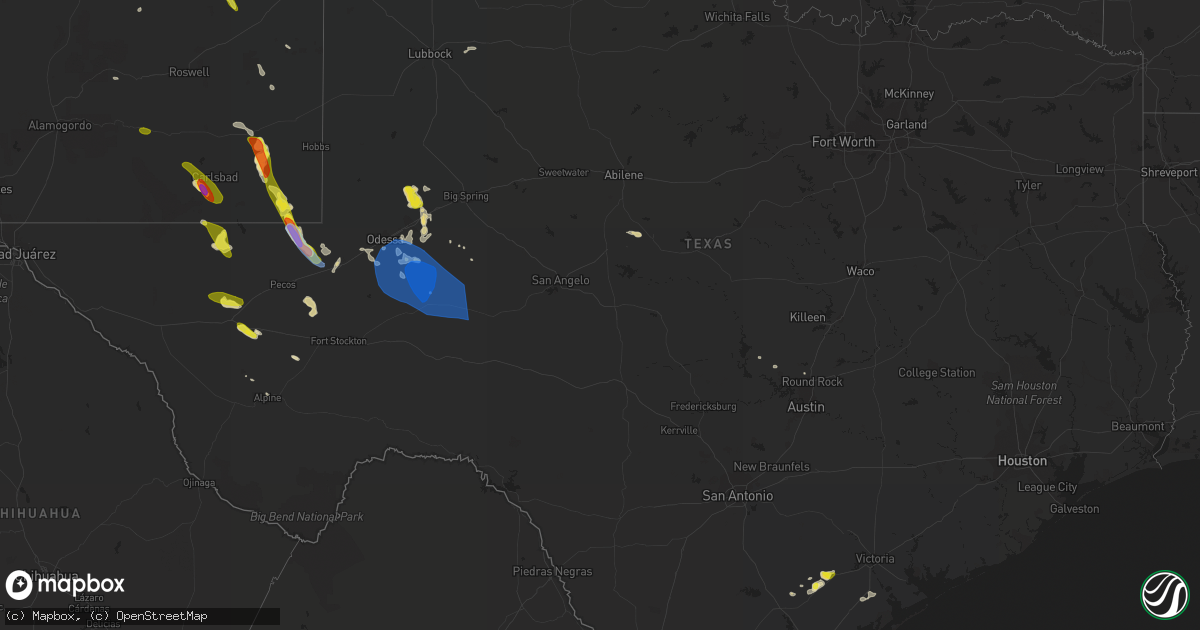
Hail Map in Texas on June 3, 2022
Get this storm
June 3 map
$229
one time, instant access
Download today. No call, no setup
Keep the $229
Bought the map and want the full workflow? Apply the entire $229 to a subscription within 7 days. None of it is wasted.
Every map, not just this one
This buys you this map. Subscription and you get every map we run, in the markets you choose from a few cities to whole states to nationwide. Plus real-time alerts the moment a storm fires.
Contact data
Name, contact info, occupancy, even credit band for addresses in the footprint. You go from where it hit to who to call.
Become the source they trust
Unlimited branding weather history reports on demand. You already have the documented answer ready for the property owner, and you are the one who showed up with it.
Property data and RoofTrace estimates
Pull up any address you have got, its value and the exact code rules for that jurisdiction, straight from One Click Code. Then RoofTrace estimates the squares, pitch, and roof value, priced the way you price.
Storm reports in Texas
Texas
| Date | Description |
|---|---|
| 06/03/20227:56 AM CDT | At 1255 AM CDT, a severe thunderstorm was located 9 miles northwest of Sundown, or 13 miles west of Levelland, moving east at 15 mph. HAZARD...60 mph wind gusts and quarter size hail. SOURCE...Radar indicated. IMPACT...Hail damage to vehicles is expected. Expect wind damage to roofs, siding, and trees. Locations impacted include... Levelland, Sundown and Whitharral. |
| 06/03/20227:07 AM CDT | At 1206 AM CDT, a severe thunderstorm was located 9 miles northwest of Plains, moving east at 30 mph. HAZARD...60 mph wind gusts and nickel size hail. SOURCE...Radar indicated. IMPACT...Expect damage to roofs, siding, and trees. Locations impacted include... Levelland, Denver City, Plains, Sundown, Bronco, Tokio and Wellman. |
| 06/03/20226:25 AM CDT | At 1125 PM CDT, a severe thunderstorm was located 8 miles north of Plains, moving southeast at 40 mph. HAZARD...60 mph wind gusts and quarter size hail. SOURCE...Radar indicated. IMPACT...Hail damage to vehicles is expected. Expect wind damage to roofs, siding, and trees. Locations impacted include... Brownfield, Denver City, Plains, Tokio and Wellman. |
| 06/03/20226:09 AM CDT | At 1108 PM CDT, severe thunderstorms were located along a line extending from 18 miles north of Big Lake to 10 miles west of Reagan County Airport to 10 miles southwest of Rankin, moving east at 65 mph. HAZARD...70 mph wind gusts and quarter size hail. SOURCE...Radar indicated. IMPACT...Hail damage to vehicles is expected. Expect considerable tree damage. Wind damage is also likely to mobile homes, roofs, and outbuildings. Locations impacted include... Big Lake, McCamey, Rankin, Reagan County Airport, Stiles, Best and Upton County Airport. |
| 06/03/20225:36 AM CDT | At 1035 PM CDT, severe thunderstorms were located along a line extending from 19 miles southwest of Garden City to 13 miles north of Rankin to near Crane, moving southeast at 40 mph. HAZARD...70 mph wind gusts and nickel size hail. SOURCE...West Texas Mesonet. IMPACT...Expect considerable tree damage. Damage is likely to mobile homes, roofs, and outbuildings. Locations impacted include... Crane, McCamey, Rankin, Stiles, Midkiff, Crane County Airport, Best, Upton County Airport, Saint Lawrence, King Mountain and Spraberry. |
| 06/03/20225:22 AM CDT | 60 mph gust measured by the asos located at burnet municipal airport. |
| 06/03/20224:11 AM CDT | At 911 PM CDT, a severe thunderstorm was located over Wink, moving southeast at 15 mph. HAZARD...Golf ball size hail and 60 mph wind gusts. SOURCE...Radar indicated. IMPACT...People and animals outdoors will be injured. Expect hail damage to roofs, siding, windows, and vehicles. Expect wind damage to roofs, siding, and trees. Locations impacted include... Monahans, Kermit, Wink, Thorntonville, Pyote, Wickett, Roy Hurd Memorial Airport, Monahans Sandhills State Park and Winkler County Airport.This includes Interstate 20 between mile markers 67 and 88. |
| 06/03/20223:39 AM CDT | At 838 PM CDT, a severe thunderstorm was located 14 miles west of Lenorah, or 21 miles north of Midland, moving southeast at 25 mph. HAZARD...60 mph wind gusts and half dollar size hail. SOURCE...Radar indicated. IMPACT...Hail damage to vehicles is expected. Expect wind damage to roofs, siding, and trees. Locations impacted include... Midland, Greenwood, Stanton, Lenorah, Tarzan, Courtney and Stanton Municipal Aiport.This includes Interstate 20 between mile markers 140 and 161. |
| 06/03/20223:26 AM CDT | At 826 PM CDT, severe thunderstorms were located along a line extending from 11 miles south of Campo to 13 miles north of Keyes to 10 miles southeast of Stonington, moving southeast at 25 mph. HAZARD...60 mph wind gusts and penny size hail. SOURCE...Radar indicated. IMPACT...Minor damage to roofs, siding, and trees is possible. Locations impacted include... Guymon, Boise City, Goodwell, Texhoma, Keyes, Eva, Hough, Griggs and Sturgis. |
| 06/03/20223:13 AM CDT | At 813 PM CDT/713 PM MDT/, a severe thunderstorm was located 15 miles southwest of Jal, moving southeast at 30 mph. HAZARD...70 mph wind gusts and half dollar size hail. SOURCE...Radar indicated. IMPACT...Hail damage to vehicles is expected. Expect considerable tree damage. Wind damage is also likely to mobile homes, roofs, and outbuildings. Locations impacted include... Kermit, Wink and Winkler County Airport. |
| 06/03/20222:50 AM CDT | Del rio asos. |
| 06/03/20222:45 AM CDT | At 744 PM CDT, a severe thunderstorm was located 7 miles southeast of Charco, or 8 miles west of Goliad, moving northeast at 15 mph. HAZARD...60 mph wind gusts and quarter size hail. SOURCE...Radar indicated. IMPACT...Hail damage to vehicles is expected. Expect wind damage to roofs, siding, and trees. Locations impacted include... Goliad, Weesatche, Weser and Ander. This includes the following highways... US Highway 183 between mile markers 628 and 646. US Highway 59 between mile markers 660 and 676. |
| 06/03/20222:37 AM CDT | At 737 PM CDT/637 PM MDT/, a severe thunderstorm was located 20 miles west of Jal, moving southeast at 30 mph. HAZARD...Ping pong ball size hail and 60 mph wind gusts. SOURCE...Radar indicated. IMPACT...People and animals outdoors will be injured. Expect hail damage to roofs, siding, windows, and vehicles. Expect wind damage to roofs, siding, and trees. Locations impacted include... Jal and Bennett. |
| 06/03/20222:29 AM CDT | At 729 PM CDT, a severe thunderstorm was located 15 miles southwest of Toyah, moving southeast at 20 mph. HAZARD...60 mph wind gusts and quarter size hail. SOURCE...Radar indicated. IMPACT...Hail damage to vehicles is expected. Expect wind damage to roofs, siding, and trees. Locations impacted include... Balmorhea and Saragosa. This includes the following highways... Interstate 10 between mile markers 179 and 210. Interstate 20 between mile markers 0 and 18. |
| 06/03/20222:26 AM CDT | At 726 PM CDT/626 PM MDT/, a severe thunderstorm was located 10 miles south of Whites City, or 26 miles south of Carlsbad, moving east at 10 mph. HAZARD...60 mph wind gusts and half dollar size hail. SOURCE...Radar indicated. IMPACT...Hail damage to vehicles is expected. Expect wind damage to roofs, siding, and trees. Locations impacted include... Loving, Malaga, Whites City, Carlsbad Caverns National Park and Cavern City Air Terminal. |
| 06/03/20222:20 AM CDT | At 719 PM CDT, a severe thunderstorm was located over Berclair, or 14 miles northeast of Beeville, moving northeast at 10 mph. HAZARD...60 mph wind gusts and quarter size hail. SOURCE...Radar indicated. IMPACT...Hail damage to vehicles is expected. Expect wind damage to roofs, siding, and trees. Locations impacted include... Pettus, Charco and Berclair. This includes the following highways... US Highway 181 near mile marker 576. US Highway 183 between mile markers 644 and 648. US Highway 59 between mile markers 668 and 686. |
| 06/03/20221:53 AM CDT | At 652 PM CDT, severe thunderstorms were located along a line extending from 4 miles west of Romero to 10 miles north of Glenrio, moving northeast at 25 mph. HAZARD...60 mph wind gusts and half dollar size hail. SOURCE...Radar indicated. IMPACT...Minor damage to roofs, siding, and trees is possible. Hail damage to vehicles is expected. Locations impacted include... Dalhart, Hartley, Adrian and Romero. |
| 06/03/20221:41 AM CDT | At 640 PM CDT, a severe thunderstorm was located over Beeville, moving east at 10 mph. HAZARD...60 mph wind gusts and quarter size hail. SOURCE...Radar indicated. IMPACT...Hail damage to vehicles is expected. Expect wind damage to roofs, siding, and trees. Locations impacted include... Beeville, Skidmore, Mineral, Normanna, Berclair and Tuleta. This includes the following highways... US Highway 181 between mile markers 580 and 600. US Highway 59 between mile markers 682 and 702. |
| 06/03/20221:13 AM CDT | At 612 PM CDT, a severe thunderstorm was located near McFaddin, and is nearly stationary. HAZARD...60 mph wind gusts and quarter size hail. SOURCE...Radar indicated. IMPACT...Hail damage to vehicles is expected. Expect wind damage to roofs, siding, and trees. Locations impacted include... Tivoli. |
| 06/03/202212:20 AM CDT | At 520 PM MDT, a severe thunderstorm was located near San Jon, or 19 miles east of Tucumcari, moving east at 25 mph. HAZARD...60 mph wind gusts and quarter size hail. SOURCE...Radar indicated. IMPACT...Hail damage to vehicles is expected. Expect wind damage to roofs, siding, and trees. Locations impacted include... San Jon, Glenrio and Bard. This includes Interstate 40 between Mile Markers 347 and 373. |
| 06/02/202211:53 PM CDT | At 452 PM MDT, a severe thunderstorm was located 7 miles southeast of Logan, or 23 miles southwest of Nara Visa, moving east at 20 mph. HAZARD...60 mph wind gusts and quarter size hail. SOURCE...Radar indicated. IMPACT...Hail damage to vehicles is expected. Expect wind damage to roofs, siding, and trees. Locations impacted include... Logan. |
| 06/02/202211:35 PM CDT | 1 wnw big lake awos. |
| 06/02/202210:20 PM CDT | At the crane mesonet. |
| 06/02/20229:01 PM CDT | A local report indicates 66 MPH wind near 3 NW WINK |
| 06/02/20228:31 PM CDT | At 130 AM CDT/1230 AM MDT/, a severe thunderstorm was located 21 miles west of Jal, moving east at 25 mph. HAZARD...60 mph wind gusts and half dollar size hail. SOURCE...Radar indicated. IMPACT...Hail damage to vehicles is expected. Expect wind damage to roofs, siding, and trees. Locations impacted include... Jal, Jal Airport and Bennett. |
| 06/02/20228:12 PM CDT | A local report indicates 1.00 inch wind near 15 W ORLA |
| 06/02/20228:09 PM CDT | A local report indicates 59 MPH wind near 4 WNW STRATFORD |
| 06/02/20228:09 PM CDT | Asos station kdht dalhart |
| 06/02/20227:39 PM CDT | Spotter reported multiple large trees snapped near fm 883. Small hail was also reported. |
All States Impacted by Hail Map on June 3, 2022
Cities Impacted by Hail Map on June 3, 2022
- Wray, CO
- Glenrock, WY
- Johnstown, NE
- Wheatland, WY
- Townsend, GA
- Champion, NE
- Kit Carson, CO
- Florissant, CO
- Grant, NE
- Venango, NE
- North Platte, NE
- Brady, NE
- Merna, NE
- Arnold, NE
- Anselmo, NE
- Stapleton, NE
- Douglas, WY
- Conchas Dam, NM
- Rock Hill, SC
- Georgetown, SC
- Eads, CO
- New Bern, NC
- Maysville, NC
- Logan, NM
- Bard, NM
- San Jon, NM
- Amherst, CO
- Otter, MT
- Torrington, WY
- Vona, CO
- Flagler, CO
- Seibert, CO
- Arapahoe, NE
- Yuma, CO
- Holyoke, CO
- Hugo, CO
- Harrison, NE
- Garden City, TX
- Weldona, CO
- Fort Morgan, CO
- Wiggins, CO
- Van Horn, TX
- Hershey, NE
- Ogallala, NE
- Paxton, NE
- Sutherland, NE
- Nara Visa, NM
- Amistad, NM
- Casper, WY
- Batesland, SD
- Joes, CO
- Akron, CO
- Brewster, NE
- Purdum, NE
- Imperial, NE
- Julesburg, CO
- Garrett, WY
- Haxtun, CO
- Pine Bluffs, WY
- Boone, CO
- Ordway, CO
- Olney Springs, CO
- Ryegate, MT
- Shawmut, MT
- Kinston, NC
- Deep Run, NC
- Burdett, KS
- Kendall, KS
- Lakin, KS
- Crawford, NE
- Pomaria, SC
- Jenkinsville, SC
- Karval, CO
- Wedgefield, SC
- Richmond Hill, GA
- Bushnell, NE
- Buffalo, WY
- Whitney, NE
- Stratton, CO
- Fleming, CO
- Otis, CO
- Sterling, CO
- Kaycee, WY
- Padroni, CO
- Edgerton, WY
- Midwest, WY
- Van Tassell, WY
- Lusk, WY
- Lingle, WY
- Idalia, CO
- Eckley, CO
- Vernon, CO
- Hillrose, CO
- Walsh, CO
- Lancaster, SC
- Heath Springs, SC
- Kershaw, SC
- Goodland, KS
- Burlington, CO
- Kanorado, KS
- Martin, SD
- Wiley, CO
- Arlington, CO
- Haswell, CO
- Sugar City, CO
- Las Animas, CO
- Alcova, WY
- Keller, WA
- Ewing, NE
- Capitan, NM
- Ulysses, KS
- Hickory Grove, SC
- York, SC
- Sharon, SC
- Blacksburg, SC
- Smyrna, SC
- Clover, SC
- Fountain Inn, SC
- Honea Path, SC
- Pelzer, SC
- Laurens, SC
- Belton, SC
- Gray Court, SC
- Athol, ID
- Dorchester, SC
- Clarkston, WA
- Pomeroy, WA
- Kirk, CO
- Kim, CO
- Trinidad, CO
- Ridgeland, SC
- Yemassee, SC
- Coosawhatchie, SC
- Mentone, TX
- Wink, TX
- Jal, NM
- Kermit, TX
- Jamestown, SC
- Huger, SC
- Campo, CO
- Keyes, OK
- Boise City, OK
- Salt Flat, TX
- Moriarty, NM
- Beeville, TX
- Tatum, NM
- Dalhart, TX
- Wagon Mound, NM
- Midland, TX
- Tarzan, TX
- Stanton, TX
- Midkiff, TX
- McCamey, TX
- Moncks Corner, SC
- Chipley, FL
- Walterboro, SC
- Woodruff, SC
- Moore, SC
- Cottondale, FL
- Tivoli, TX
- Whiteville, NC
- Clarendon, NC
- Tabor City, NC
- Nakina, NC
- Fort Stockton, TX
- Yeso, NM
- Fort Sumner, NM
- Vaughn, NM
- Waxhaw, NC
- Lumpkin, GA
- Goliad, TX
- Harrells, NC
- Ivanhoe, NC
- Pinetown, NC
- Washington, NC
- Bath, NC
- Blounts Creek, NC
- Chocowinity, NC
- Lake Park, GA
- Burnet, TX
- Oakley, KS
- Merriman, NE
- Goodwell, OK
- Fort Davis, TX
- Sublette, KS
- Satanta, KS
- Monahans, TX
- Balmorhea, TX
- Cuthbert, GA
- Morris, GA
- Roswell, NM
- Bertram, TX
- Gove, KS
- Parks, NE
- Garden City, KS
- Decker, MT
- Orchard, CO
- Balko, OK
- Hooker, OK
- Turpin, OK
- Elkhart, KS
- Simpsonville, SC
- Greer, SC
- Greenville, SC
- Jonesville, SC
- Roebuck, SC
- Taylors, SC
- Duncan, SC
- Spartanburg, SC
- Pauline, SC
- Catawba, SC
- Monroe, NC
- Alpine, TX
- Bethune, CO
- Lovington, NM
- Hobbs, NM
- Walsenburg, CO
- Novice, TX
- Coleman, TX
- Grantsboro, NC
- Arapahoe, NC
- Aguilar, CO
- Cheraw, SC
- Mount Croghan, SC
- Jefferson, SC
- Patrick, SC
- Ruby, SC
- Chesterfield, SC
- Pageland, SC
- Pantego, NC
- Swanquarter, NC
- Roper, NC
- Plymouth, NC
- Belhaven, NC
- Jamesville, NC
- Fairfield, NC
- Engelhard, NC
- Creswell, NC
- Rochelle, GA
- Rebecca, GA
- Attapulgus, GA
- Georgetown, TX
- Artesia, NM
- Dover, NC
- Pecos, TX
- Coyanosa, TX
- Odessa, TX
- Tinnie, NM
- Savannah, GA
- Tillman, SC
- Garnett, SC
- Hanston, KS
- Johnsonville, SC
- Pamplico, SC
- Thibodaux, LA
- Trenton, NC
- Waynesboro, GA
- Keysville, GA
- Carlsbad, NM
- Quincy, FL
- Shellman, GA
- Sheridan Lake, CO
- Grinnell, KS
- Wakeeney, KS
- Claxton, GA
- Grifton, NC
- Cordesville, SC
- Hampstead, NC
- Holly Ridge, NC
- Havelock, NC
- Santa Rosa, NM
- Ralls, TX
- Lorenzo, TX
- Branson, CO
- Trementina, NM
- Vidalia, GA
- Milton, FL
- Opp, AL
- Cottageville, SC
- Ridgeville, SC
- Jacksonville, NC
- Manning, SC
- Elida, NM
- Florala, AL
- Holcomb, KS
- Lamar, SC
- Timmonsville, SC
- Lenorah, TX
- Abbeville, GA
- Edgemoor, SC
- Deerfield, KS
- Big Lake, TX
- Crane, TX
- Rankin, TX
- Murrells Inlet, SC
- Copeland, KS
- Montezuma, KS
- Johnson, KS
- Ingalls, KS
- Cheyenne Wells, CO
- Leoti, KS
- Arapahoe, CO
- Tribune, KS
- Saint Francis, KS
- Haigler, NE
- Loving, NM
- Solano, NM
- Hope, NM


