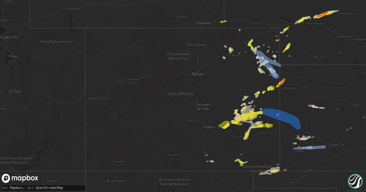
Hail Map in Colorado on June 3, 2022
Get this storm
June 3 map
$229
one time, instant access
Download today. No call, no setup
Keep the $229
Bought the map and want the full workflow? Apply the entire $229 to a subscription within 7 days. None of it is wasted.
Every map, not just this one
This buys you this map. Subscription and you get every map we run, in the markets you choose from a few cities to whole states to nationwide. Plus real-time alerts the moment a storm fires.
Contact data
Name, contact info, occupancy, even credit band for addresses in the footprint. You go from where it hit to who to call.
Become the source they trust
Unlimited branding weather history reports on demand. You already have the documented answer ready for the property owner, and you are the one who showed up with it.
Property data and RoofTrace estimates
Pull up any address you have got, its value and the exact code rules for that jurisdiction, straight from One Click Code. Then RoofTrace estimates the squares, pitch, and roof value, priced the way you price.
Storm reports in Colorado
Colorado
| Date | Description |
|---|---|
| 06/03/20226:53 PM CDT | Spotter reported hail beginning with pea... Increasing to a few quarters in size. Hail is now back down to pea with heavy rain falling. |
| 06/03/20226:43 PM CDT | Photo evidence of a tornado associated with the occlusion of the circulation south of the earlier bent county tornadic circulation. Tornado lasted approximately 5 minut |
| 06/03/20226:33 PM CDT | Dispatch relayed a report of heavy rain with hail up to the size of quarters around mile marker 129 on highway 287. |
| 06/03/20226:30 PM CDT | A local report indicates 1.50 inch wind near 3 WNW REIRADON HILL |
| 06/03/20226:23 PM CDT | Corrects previous tornado report from 4 n fort lyon. A tornado was confirmed by an induvial who was picked up in a truck... Rotated 120 degrees... Had his windows blown |
| 06/03/20226:22 PM CDT | A local report indicates 1.00 inch wind near LAS ANIMAS |
| 06/03/20226:12 PM CDT | A local report indicates 1.00 inch wind near 1 WNW LAS ANIMAS |
| 06/03/20226:01 PM CDT | Storm chaser reported via spotter network. |
| 06/03/20226:00 PM CDT | Landspout. Initial updrafts of developing thunderstorms interacted with an outflow boundary and produced a landspout tornado... Which was on the ground for approximatel |
| 06/03/20222:09 AM CDT | At 708 PM MDT, a severe thunderstorm was located 13 miles southwest of Stonington, or 24 miles west of Elkhart, moving east at 45 mph. HAZARD...60 mph wind gusts and quarter size hail. SOURCE...Radar indicated. IMPACT...Hail damage to vehicles is expected. Expect wind damage to roofs, siding, and trees. This severe thunderstorm will remain over mainly rural areas of southeastern Baca County. |
| 06/03/20221:54 AM CDT | At 654 PM MDT, severe thunderstorms were located along a line extending from 6 miles south of Weskan to 6 miles east of Towner, moving east at 25 mph. HAZARD...70 mph wind gusts and quarter size hail. SOURCE...Radar indicated. IMPACT...Hail damage to vehicles is expected. Expect considerable tree damage. Wind damage is also likely to mobile homes, roofs, and outbuildings. Locations impacted include... Horace and Tribune. |
| 06/03/20221:28 AM CDT | At 628 PM MDT/728 PM CDT/, a severe thunderstorm was located 11 miles southeast of Bonny Reservoir, moving northeast at 25 mph. HAZARD...60 mph wind gusts and quarter size hail. SOURCE...Radar indicated. IMPACT...Hail damage to vehicles is expected. Expect wind damage to roofs, siding, and trees. This severe thunderstorm will remain over mainly rural areas of southeastern Yuma County in northeastern Colorado, northeastern Kit Carson County in east central Colorado, southwestern Cheyenne and northwestern Sherman Counties in northwestern Kansas, including the following locations... Hale.This includes Interstate 70 in Kansas near mile marker 2. |
| 06/03/20221:17 AM CDT | At 617 PM MDT, a severe thunderstorm was located over Pritchett, or 14 miles west of Springfield, moving northeast at 30 mph. HAZARD...60 mph wind gusts and quarter size hail. SOURCE...Radar indicated. IMPACT...Hail damage to vehicles is expected. Expect wind damage to roofs, siding, and trees. Locations impacted include... Springfield, Pritchett, Vilas, Campo and Two Buttes Reservoir. |
| 06/03/20221:14 AM CDT | At 613 PM MDT, severe thunderstorms were located along a line extending from 12 miles north of Sheridan Lake to 11 miles northwest of Bristol to 17 miles southwest of Lamar, moving southeast at 55 mph. HAZARD...70 mph wind gusts and ping pong ball size hail. SOURCE...Radar indicated. IMPACT...People and animals outdoors will be injured. Expect hail damage to roofs, siding, windows, and vehicles. Expect considerable tree damage. Wind damage is also likely to mobile homes, roofs, and outbuildings. Locations impacted include... Holly, Granada, Sheridan Lake, Hartman, Towner and Bristol. |
| 06/03/20221:10 AM CDT | At 610 PM MDT, severe thunderstorms were located along a line extending from near Lone Star to 9 miles northwest of Elba, or along a line extending from 19 miles north of Yuma to 9 miles southwest of Akron, moving east at 30 mph. HAZARD...60 mph wind gusts and quarter size hail. SOURCE...Radar indicated. IMPACT...Expect damage to roofs, siding, and trees. Hail damage to vehicles is expected. Severe thunderstorms will be near... Lone Star around 615 PM MDT. |
| 06/03/202212:58 AM CDT | At 558 PM MDT/658 PM CDT/, a severe thunderstorm was located 9 miles north of Burlington, moving northeast at 40 mph. HAZARD...60 mph wind gusts and quarter size hail. SOURCE...Radar indicated. IMPACT...Hail damage to vehicles is expected. Expect wind damage to roofs, siding, and trees. Locations impacted include... Bonny Reservoir.This includes the following highways... Interstate 70 in Colorado between mile markers 435 and 448. Highway 385 between mile markers 184 and 217. |
| 06/03/202212:55 AM CDT | At 555 PM MDT, severe thunderstorms were located along a line extending from near Cheyenne Wells to 12 miles north of Brandon, moving east at 25 mph. HAZARD...60 mph wind gusts and quarter size hail. SOURCE...Radar indicated. IMPACT...Hail damage to vehicles is expected. Expect wind damage to roofs, siding, and trees. Severe thunderstorms will be near... Cheyenne Wells around 600 PM MDT.This includes Highway 385 between mile markers 136 and 159. |
| 06/03/202212:53 AM CDT | At 553 PM MDT, severe thunderstorms were located along a line extending from 6 miles southwest of Fleming to 9 miles north of Akron, moving southeast at 25 mph. HAZARD...60 mph wind gusts and half dollar size hail. SOURCE...Trained weather spotters. IMPACT...Hail damage to vehicles is expected. Expect wind damage to roofs, siding, and trees. Locations impacted include... Yuma.This includes Highway 385 between mile markers 268 and 270. |
| 06/03/202212:52 AM CDT | At 552 PM MDT, a severe thunderstorm was located 12 miles west of Pritchett, or 25 miles west of Springfield, moving east at 30 mph. HAZARD...60 mph wind gusts and quarter size hail. SOURCE...Radar indicated. IMPACT...Hail damage to vehicles is expected. Expect wind damage to roofs, siding, and trees. Locations impacted include... Pritchett and Kim. |
| 06/03/202212:44 AM CDT | At 544 PM MDT, severe thunderstorms were located along a line extending from near Sweetwater Reservoir to 15 miles east of Higbee, moving east at 25 mph. HAZARD...Golf ball size hail and 70 mph wind gusts. SOURCE...Trained spotters reported large hail with this activity, which earlier produced tornadoes. These storms have already produced severe weather. IMPACT...People and animals outdoors will be injured. Expect hail damage to roofs, siding, windows, and vehicles. Expect considerable tree damage. Wind damage is also likely to mobile homes, roofs, and outbuildings. Locations impacted include... Lamar, Wiley, McClave, Hasty, John Martin Reservoir, Fort Lyon and Caddoa. |
| 06/03/202212:36 AM CDT | At 536 PM MDT, severe thunderstorms were located along a line extending from 12 miles northeast of Eads to 10 miles north of Hasty, moving east at 35 mph. HAZARD...Golf ball size hail and 70 mph wind gusts. SOURCE...Radar indicated. IMPACT...People and animals outdoors will be injured. Expect hail damage to roofs, siding, windows, and vehicles. Expect considerable tree damage. Wind damage is also likely to mobile homes, roofs, and outbuildings. Severe thunderstorms will be near... Neegronda Reservoir and Sweetwater Reservoir around 555 PM MDT.Other locations in the path of these severe thunderstorms includeNeeoshe Reservoir and Queens Reservoir. |
| 06/03/202212:31 AM CDT | At 531 PM MDT, a severe thunderstorm was located near Bethune, or 9 miles west of Burlington, moving northeast at 20 mph. HAZARD...Golf ball size hail and 60 mph wind gusts. SOURCE...Radar indicated. IMPACT...People and animals outdoors will be injured. Expect hail damage to roofs, siding, windows, and vehicles. Expect wind damage to roofs, siding, and trees. This severe thunderstorm will remain over mainly rural areas of northeastern Kit Carson County.This includes Highway 385 between mile markers 192 and 200. |
| 06/03/202212:26 AM CDT | At 525 PM MDT, a severe thunderstorm was located 6 miles south of Sterling, moving east at 15 mph. HAZARD...60 mph wind gusts and half dollar size hail. SOURCE...Radar indicated. IMPACT...Expect damage to roofs, siding, and trees. Hail damage to vehicles is expected. This severe thunderstorm will remain over mainly rural areas of south central Logan County, including the following locations... Reiradon Hill. |
| 06/03/202212:18 AM CDT | At 517 PM MDT, severe thunderstorms were located along a line extending from 4 miles east of Antelope Springs to near Adena School, or along a line extending from 26 miles southwest of Sterling to 9 miles south of Fort Morgan, moving southeast at 35 mph. HAZARD...70 mph wind gusts. SOURCE...Radar indicated. IMPACT...Expect considerable tree damage. Damage is likely to mobile homes, roofs, and outbuildings. Severe thunderstorms will be near... Brush around 525 PM MDT. Hillrose and Gary around 535 PM MDT. |
| 06/03/202212:13 AM CDT | At 513 PM MDT, severe thunderstorms were located along a line extending from near Las Animas to 10 miles northeast of Higbee, moving southeast at 35 mph. HAZARD...Golf ball size hail and 70 mph wind gusts. SOURCE...Radar indicated. IMPACT...People and animals outdoors will be injured. Expect hail damage to roofs, siding, windows, and vehicles. Expect considerable tree damage. Wind damage is also likely to mobile homes, roofs, and outbuildings. Locations impacted include... Las Animas, Hasty, McClave, John Martin Reservoir, Fort Lyon and Caddoa. |
| 06/03/202212:09 AM CDT | At 509 PM MDT, a severe thunderstorm was located near Kim, or 40 miles northeast of Des Moines, moving southeast at 15 mph. HAZARD...70 mph wind gusts and ping pong ball size hail. SOURCE...Radar indicated. IMPACT...People and animals outdoors will be injured. Expect hail damage to roofs, siding, windows, and vehicles. Expect considerable tree damage. Wind damage is also likely to mobile homes, roofs, and outbuildings. Locations impacted include... Kim. |
| 06/02/202211:59 PM CDT | At 459 PM MDT, severe thunderstorms were located along a line extending from 4 miles south of Vona to 9 miles northwest of Eads, moving east at 30 mph. HAZARD...60 mph wind gusts and quarter size hail. SOURCE...Radar indicated. IMPACT...Hail damage to vehicles is expected. Expect wind damage to roofs, siding, and trees. Severe thunderstorms will be near... Stratton around 515 PM MDT.Other locations in the path of these severe thunderstorms includeBethune and Burlington.This includes the following highways... Interstate 70 in Colorado between mile markers 411 and 442. Highway 385 between mile markers 136 and 191. |
| 06/02/202211:57 PM CDT | At 457 PM MDT, a severe thunderstorm was located near Aguilar, or 20 miles northwest of Trinidad, moving east at 25 mph. HAZARD...60 mph wind gusts and half dollar size hail. SOURCE...Radar indicated. IMPACT...Hail damage to vehicles is expected. Expect wind damage to roofs, siding, and trees. This severe thunderstorm will be near... Aguilar around 510 PM MDT. |
| 06/02/202211:48 PM CDT | At 447 PM MDT, severe thunderstorms were located along a line extending from 10 miles northeast of Haswell to 10 miles west of Arlington, moving east at 30 mph. THESE ARE DESTRUCTIVE STORMS FOR EADS, ARLINGTON, AND HASWELL. HAZARD...Baseball size hail and 70 mph wind gusts. SOURCE...Radar indicated. IMPACT...People and animals outdoors will be severely injured. Expect shattered windows, extensive damage to roofs, siding, and vehicles. Locations impacted include... Eads, Haswell, Blue Lake and Arlington. |
| 06/02/202211:45 PM CDT | At 444 PM MDT, severe thunderstorms were located over northwest Morgan County, moving southeast at 20 mph. HAZARD...60 mph wind gusts and quarter size hail. SOURCE...Radar indicated. IMPACT...Expect damage to roofs, siding, and trees. Hail damage to vehicles is expected. Severe thunderstorms will be near... Antelope Springs around 455 PM MDT.Other locations in the path of these severe thunderstorms includeFort Morgan, Log Lane Village and Brush. |
| 06/02/202211:42 PM CDT | At 441 PM MDT, a severe thunderstorm was located 11 miles northwest of Kim, or 41 miles northeast of Des Moines, moving east at 20 mph. HAZARD...Two inch hail and 70 mph wind gusts. SOURCE...Radar indicated. IMPACT...People and animals outdoors will be injured. Expect hail damage to roofs, siding, windows, and vehicles. Expect considerable tree damage. Wind damage is also likely to mobile homes, roofs, and outbuildings. Locations impacted include... Kim. |
| 06/02/202211:25 PM CDT | At 425 PM MDT, severe thunderstorms were located along a line extending from 8 miles southeast of Wild Horse Point to near Crowley, moving east at 35 mph. HAZARD...Two inch hail and 70 mph wind gusts. SOURCE...Radar indicated. IMPACT...People and animals outdoors will be injured. Expect hail damage to roofs, siding, windows, and vehicles. Expect considerable tree damage. Wind damage is also likely to mobile homes, roofs, and outbuildings. Locations impacted include... La Junta, North La Junta, Rocky Ford, Las Animas, Swink, Cheraw, Haswell, Blue Lake, Arlington, John Martin Reservoir and Fort Lyon. |
| 06/02/202210:54 PM CDT | At 353 PM MDT, severe thunderstorms were located along a line extending from 6 miles south of Flagler to 8 miles southwest of Wild Horse Point, moving east at 30 mph. HAZARD...60 mph wind gusts and quarter size hail. SOURCE...Radar indicated. IMPACT...Hail damage to vehicles is expected. Expect wind damage to roofs, siding, and trees. Severe thunderstorms will be near... Flagler around 400 PM MDT.Other locations in the path of these severe thunderstorms includeSeibert, Vona, Stratton and Bethune.This includes Interstate 70 in Colorado between mile markers 391 and431. |
| 06/02/202210:52 PM CDT | At 352 PM MDT, severe thunderstorms were located along a line extending from 11 miles west of Kim to 13 miles north of Branson to near Model, moving northwest at 10 mph. HAZARD...60 mph wind gusts and half dollar size hail. SOURCE...Radar indicated. IMPACT...Hail damage to vehicles is expected. Expect wind damage to roofs, siding, and trees. These severe thunderstorms will remain over mainly rural areas of southeastern Las Animas County. |
| 06/02/202210:48 PM CDT | At 348 PM MDT, developing severe thunderstorms were located along a line extending from 13 miles south of Forder to 7 miles east of Boone, moving east at 35 mph. HAZARD...60 mph wind gusts and quarter size hail. SOURCE...Radar indicated. IMPACT...Hail damage to vehicles is expected. Expect wind damage to roofs, siding, and trees. Locations impacted include... La Junta, Rocky Ford, Fowler, Ordway, Swink, Manzanola, Olney Springs, Sugar City and Crowley. |
| 06/02/202210:46 PM CDT | At 346 PM MDT, severe thunderstorms were located along a line extending from 9 miles north of Boyero to 9 miles northeast of Karval to 6 miles south of Forder, or along a line extending from 18 miles southwest of Flagler to 69 miles southwest of Burlington to 41 miles north of North La Junta, moving southeast at 30 mph. HAZARD...60 mph wind gusts and quarter size hail. SOURCE...Radar indicated. IMPACT...Expect damage to roofs, siding, and trees. Hail damage to vehicles is expected. Severe thunderstorms will be near... Wild Horse Point around 405 PM MDT. |
| 06/02/202210:12 PM CDT | At 311 PM MDT, a cluster of developing severe thunderstorms was located over southern Pueblo County and east central Custer County, moving northeast at 30 mph. HAZARD...60 mph wind gusts and quarter size hail. SOURCE...Radar indicated. IMPACT...Hail damage to vehicles is expected. Expect wind damage to roofs, siding, and trees. Locations impacted include... Pueblo, Boone, Salt Creek, Blende, Avondale, Pueblo Depot, Greenhorn Mountain, Rye, Beulah, San Isabel and Colorado City. |
| 06/02/202210:01 PM CDT | At 300 PM MDT, severe thunderstorms were located along a line extending from 9 miles northwest of Hoehne to near Boncarbo, moving southeast at 30 mph. HAZARD...60 mph wind gusts and quarter size hail. SOURCE...Radar indicated. IMPACT...Hail damage to vehicles is expected. Expect wind damage to roofs, siding, and trees. Locations impacted include... Trinidad, Cokedale, Starkville, Boncarbo, Model, Hoehne and Tyrone. |
| 06/02/20228:44 PM CDT | Site 385n21956rws1sec. |
| 06/02/20228:40 PM CDT | Delayed report of a landspout observed looking south from the intersection of us-36 and us-385. Exact location of landspout unknown. Media personnel estimated it was ro |
| 06/02/20228:34 PM CDT | Mesonet station co047 385n220 idalia. |
| 06/02/20228:17 PM CDT | Site welp farms. |
| 06/02/20228:15 PM CDT | Caller reported a rope funnel that briefly touched the ground a few miles west of the town of wray. Tornado was not on the ground as of the call. |
| 06/02/20227:58 PM CDT | Delayed report. Weak tornado spotted beginning at roughly 6:58pm. Persisted for approximately 8 minutes with a visible ground circulation and funnel. |
| 06/02/20227:37 PM CDT | Reported hail growing from pea to quarter sized. Still falling as of the call. |
| 06/02/20227:37 PM CDT | Reported 60 mph gust on personal station. |
| 06/02/20227:25 PM CDT | Dispatch relayed a report of near zero visibility in rain with estimated 60 to 70 mph wind gusts. |
| 06/02/20227:03 PM CDT | Mesonet station ew7755 akron. |
All States Impacted by Hail Map on June 3, 2022
Cities Impacted by Hail Map on June 3, 2022
- Wray, CO
- Glenrock, WY
- Johnstown, NE
- Wheatland, WY
- Townsend, GA
- Champion, NE
- Kit Carson, CO
- Florissant, CO
- Grant, NE
- Venango, NE
- North Platte, NE
- Brady, NE
- Merna, NE
- Arnold, NE
- Anselmo, NE
- Stapleton, NE
- Douglas, WY
- Conchas Dam, NM
- Rock Hill, SC
- Georgetown, SC
- Eads, CO
- New Bern, NC
- Maysville, NC
- Logan, NM
- Bard, NM
- San Jon, NM
- Amherst, CO
- Otter, MT
- Torrington, WY
- Vona, CO
- Flagler, CO
- Seibert, CO
- Arapahoe, NE
- Yuma, CO
- Holyoke, CO
- Hugo, CO
- Harrison, NE
- Garden City, TX
- Weldona, CO
- Fort Morgan, CO
- Wiggins, CO
- Van Horn, TX
- Hershey, NE
- Ogallala, NE
- Paxton, NE
- Sutherland, NE
- Nara Visa, NM
- Amistad, NM
- Casper, WY
- Batesland, SD
- Joes, CO
- Akron, CO
- Brewster, NE
- Purdum, NE
- Imperial, NE
- Julesburg, CO
- Garrett, WY
- Haxtun, CO
- Pine Bluffs, WY
- Boone, CO
- Ordway, CO
- Olney Springs, CO
- Ryegate, MT
- Shawmut, MT
- Kinston, NC
- Deep Run, NC
- Burdett, KS
- Kendall, KS
- Lakin, KS
- Crawford, NE
- Pomaria, SC
- Jenkinsville, SC
- Karval, CO
- Wedgefield, SC
- Richmond Hill, GA
- Bushnell, NE
- Buffalo, WY
- Whitney, NE
- Stratton, CO
- Fleming, CO
- Otis, CO
- Sterling, CO
- Kaycee, WY
- Padroni, CO
- Edgerton, WY
- Midwest, WY
- Van Tassell, WY
- Lusk, WY
- Lingle, WY
- Idalia, CO
- Eckley, CO
- Vernon, CO
- Hillrose, CO
- Walsh, CO
- Lancaster, SC
- Heath Springs, SC
- Kershaw, SC
- Goodland, KS
- Burlington, CO
- Kanorado, KS
- Martin, SD
- Wiley, CO
- Arlington, CO
- Haswell, CO
- Sugar City, CO
- Las Animas, CO
- Alcova, WY
- Keller, WA
- Ewing, NE
- Capitan, NM
- Ulysses, KS
- Hickory Grove, SC
- York, SC
- Sharon, SC
- Blacksburg, SC
- Smyrna, SC
- Clover, SC
- Fountain Inn, SC
- Honea Path, SC
- Pelzer, SC
- Laurens, SC
- Belton, SC
- Gray Court, SC
- Athol, ID
- Dorchester, SC
- Clarkston, WA
- Pomeroy, WA
- Kirk, CO
- Kim, CO
- Trinidad, CO
- Ridgeland, SC
- Yemassee, SC
- Coosawhatchie, SC
- Mentone, TX
- Wink, TX
- Jal, NM
- Kermit, TX
- Jamestown, SC
- Huger, SC
- Campo, CO
- Keyes, OK
- Boise City, OK
- Salt Flat, TX
- Moriarty, NM
- Beeville, TX
- Tatum, NM
- Dalhart, TX
- Wagon Mound, NM
- Midland, TX
- Tarzan, TX
- Stanton, TX
- Midkiff, TX
- McCamey, TX
- Moncks Corner, SC
- Chipley, FL
- Walterboro, SC
- Woodruff, SC
- Moore, SC
- Cottondale, FL
- Tivoli, TX
- Whiteville, NC
- Clarendon, NC
- Tabor City, NC
- Nakina, NC
- Fort Stockton, TX
- Yeso, NM
- Fort Sumner, NM
- Vaughn, NM
- Waxhaw, NC
- Lumpkin, GA
- Goliad, TX
- Harrells, NC
- Ivanhoe, NC
- Pinetown, NC
- Washington, NC
- Bath, NC
- Blounts Creek, NC
- Chocowinity, NC
- Lake Park, GA
- Burnet, TX
- Oakley, KS
- Merriman, NE
- Goodwell, OK
- Fort Davis, TX
- Sublette, KS
- Satanta, KS
- Monahans, TX
- Balmorhea, TX
- Cuthbert, GA
- Morris, GA
- Roswell, NM
- Bertram, TX
- Gove, KS
- Parks, NE
- Garden City, KS
- Decker, MT
- Orchard, CO
- Balko, OK
- Hooker, OK
- Turpin, OK
- Elkhart, KS
- Simpsonville, SC
- Greer, SC
- Greenville, SC
- Jonesville, SC
- Roebuck, SC
- Taylors, SC
- Duncan, SC
- Spartanburg, SC
- Pauline, SC
- Catawba, SC
- Monroe, NC
- Alpine, TX
- Bethune, CO
- Lovington, NM
- Hobbs, NM
- Walsenburg, CO
- Novice, TX
- Coleman, TX
- Grantsboro, NC
- Arapahoe, NC
- Aguilar, CO
- Cheraw, SC
- Mount Croghan, SC
- Jefferson, SC
- Patrick, SC
- Ruby, SC
- Chesterfield, SC
- Pageland, SC
- Pantego, NC
- Swanquarter, NC
- Roper, NC
- Plymouth, NC
- Belhaven, NC
- Jamesville, NC
- Fairfield, NC
- Engelhard, NC
- Creswell, NC
- Rochelle, GA
- Rebecca, GA
- Attapulgus, GA
- Georgetown, TX
- Artesia, NM
- Dover, NC
- Pecos, TX
- Coyanosa, TX
- Odessa, TX
- Tinnie, NM
- Savannah, GA
- Tillman, SC
- Garnett, SC
- Hanston, KS
- Johnsonville, SC
- Pamplico, SC
- Thibodaux, LA
- Trenton, NC
- Waynesboro, GA
- Keysville, GA
- Carlsbad, NM
- Quincy, FL
- Shellman, GA
- Sheridan Lake, CO
- Grinnell, KS
- Wakeeney, KS
- Claxton, GA
- Grifton, NC
- Cordesville, SC
- Hampstead, NC
- Holly Ridge, NC
- Havelock, NC
- Santa Rosa, NM
- Ralls, TX
- Lorenzo, TX
- Branson, CO
- Trementina, NM
- Vidalia, GA
- Milton, FL
- Opp, AL
- Cottageville, SC
- Ridgeville, SC
- Jacksonville, NC
- Manning, SC
- Elida, NM
- Florala, AL
- Holcomb, KS
- Lamar, SC
- Timmonsville, SC
- Lenorah, TX
- Abbeville, GA
- Edgemoor, SC
- Deerfield, KS
- Big Lake, TX
- Crane, TX
- Rankin, TX
- Murrells Inlet, SC
- Copeland, KS
- Montezuma, KS
- Johnson, KS
- Ingalls, KS
- Cheyenne Wells, CO
- Leoti, KS
- Arapahoe, CO
- Tribune, KS
- Saint Francis, KS
- Haigler, NE
- Loving, NM
- Solano, NM
- Hope, NM


