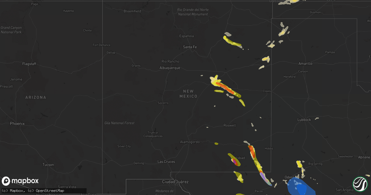
Hail Map in New Mexico on June 3, 2022
Get this storm
June 3 map
$229
one time, instant access
Download today. No call, no setup
Keep the $229
Bought the map and want the full workflow? Apply the entire $229 to a subscription within 7 days. None of it is wasted.
Every map, not just this one
This buys you this map. Subscription and you get every map we run, in the markets you choose from a few cities to whole states to nationwide. Plus real-time alerts the moment a storm fires.
Contact data
Name, contact info, occupancy, even credit band for addresses in the footprint. You go from where it hit to who to call.
Become the source they trust
Unlimited branding weather history reports on demand. You already have the documented answer ready for the property owner, and you are the one who showed up with it.
Property data and RoofTrace estimates
Pull up any address you have got, its value and the exact code rules for that jurisdiction, straight from One Click Code. Then RoofTrace estimates the squares, pitch, and roof value, priced the way you price.
Storm reports in New Mexico
New Mexico
| Date | Description |
|---|---|
| 06/03/20226:49 PM CDT | A local report indicates 1.75 inch wind near 2 ENE HALFWAY |
| 06/03/20226:36 PM CDT | A local report indicates 1.75 inch wind near YESO |
| 06/03/20226:18 PM CDT | A local report indicates 1.00 inch wind near 3 WSW SEVEN RIVERS |
| 06/03/20223:55 PM CDT | Quarter size hail along u.s. 82. |
| 06/03/20223:16 AM CDT | At 816 PM MDT, severe thunderstorms were located along a line extending from 22 miles south of Taiban to 19 miles northeast of Mesa, moving east at 25 mph. HAZARD...60 mph wind gusts and quarter size hail. SOURCE...Radar indicated. IMPACT...Hail damage to vehicles is expected. Expect wind damage to roofs, siding, and trees. These severe thunderstorms will remain over mainly rural areas of west central Roosevelt, southeastern De Baca and north central Chaves Counties. |
| 06/03/20223:11 AM CDT | At 810 PM CDT, a severe thunderstorm was located 14 miles southwest of Red Bluff Reservoir, or 34 miles west of Mentone, moving east at 15 mph. HAZARD...60 mph wind gusts and half dollar size hail. SOURCE...Radar indicated. IMPACT...Hail damage to vehicles is expected. Expect wind damage to roofs, siding, and trees. Locations impacted include... Red Bluff Reservoir, Orla and Red Bluff. |
| 06/03/20222:14 AM CDT | At 714 PM MDT, a severe thunderstorm was located 8 miles west of Yeso, or 29 miles west of Fort Sumner, moving east at 20 mph. HAZARD...60 mph wind gusts and quarter size hail. SOURCE...Radar indicated. IMPACT...Hail damage to vehicles is expected. Expect wind damage to roofs, siding, and trees. Locations impacted include... Fort Sumner and Yeso. This includes Highway 60 between Mile Markers 292 and 337. |
| 06/03/20221:12 AM CDT | At 611 PM MDT, a severe thunderstorm was located 10 miles southwest of Fort Sumner, moving southeast at 20 mph. HAZARD...60 mph wind gusts and quarter size hail. SOURCE...Radar indicated. IMPACT...Hail damage to vehicles is expected. Expect wind damage to roofs, siding, and trees. Locations impacted include... Fort Sumner, Yeso, Taiban, Sumner Lake State Park and Sumner Lake. This includes Highway 60 between Mile Markers 286 and 345. |
| 06/03/202212:55 AM CDT | At 555 PM MDT, a severe thunderstorm was located 24 miles south of Maljamar, or 31 miles east of Carlsbad, moving south at 15 mph. HAZARD...Golf ball size hail and 60 mph wind gusts. SOURCE...Radar indicated. IMPACT...People and animals outdoors will be injured. Expect hail damage to roofs, siding, windows, and vehicles. Expect wind damage to roofs, siding, and trees. Locations impacted include... Halfway. |
| 06/03/202212:42 AM CDT | At 542 PM MDT, a severe thunderstorm was located 11 miles southwest of Brantley Lake State Park, or 14 miles west of Carlsbad, moving southeast at 15 mph. HAZARD...60 mph wind gusts and half dollar size hail. SOURCE...Radar indicated. IMPACT...Hail damage to vehicles is expected. Expect wind damage to roofs, siding, and trees. Locations impacted include... Carlsbad, Loving, Whites City, Carlsbad Caverns National Park, Otis, Cavern City Air Terminal and Living Desert State Park. |
| 06/03/202212:14 AM CDT | At 514 PM MDT, a severe thunderstorm was located 12 miles northwest of Yeso, or 25 miles east of Vaughn, moving east at 15 mph. HAZARD...60 mph wind gusts and quarter size hail. SOURCE...Radar indicated. IMPACT...Hail damage to vehicles is expected. Expect wind damage to roofs, siding, and trees. Locations impacted include... Vaughn, Yeso, Sumner Lake State Park and Sumner Lake. This includes the following highways... Highway 285 between Mile Markers 198 and 204. Highway 60 between Mile Markers 272 and 319. |
| 06/03/202212:10 AM CDT | At 510 PM MDT, a severe thunderstorm was located 10 miles south of Maljamar, or 27 miles southwest of Lovington, moving southeast at 15 mph. HAZARD...Tennis ball size hail and 60 mph wind gusts. SOURCE...Radar indicated. IMPACT...People and animals outdoors will be injured. Expect hail damage to roofs, siding, windows, and vehicles. Expect wind damage to roofs, siding, and trees. Locations impacted include... Halfway. |
| 06/03/202212:04 AM CDT | At 504 PM MDT, a severe thunderstorm was located 8 miles northeast of Wagon Mound, moving east at 20 mph. HAZARD...60 mph wind gusts and quarter size hail. SOURCE...Radar indicated. IMPACT...Hail damage to vehicles is expected. Expect wind damage to roofs, siding, and trees. Locations impacted include... Wagon Mound and Mills. This includes Interstate 25 between Mile Markers 383 and 401. |
| 06/03/202212:00 AM CDT | At 500 PM MDT, a severe thunderstorm was located 11 miles west of Seven Rivers Airport, or 18 miles south of Hope, moving southeast at 15 mph. HAZARD...60 mph wind gusts and quarter size hail. SOURCE...Radar indicated. IMPACT...Hail damage to vehicles is expected. Expect wind damage to roofs, siding, and trees. Locations impacted include... Avalon, Brantley Lake State Park, Seven Rivers Airport, Lake Avalon and Living Desert State Park. |
| 06/02/202211:59 PM CDT | At 459 PM MDT, a severe thunderstorm was located 9 miles southeast of Bueyeros, or 21 miles west of Amistad, moving east at 20 mph. HAZARD...60 mph wind gusts and quarter size hail. SOURCE...Radar indicated. IMPACT...Hail damage to vehicles is expected. Expect wind damage to roofs, siding, and trees. Locations impacted include... Amistad, Hayden and Rosebud. |
| 06/02/202211:28 PM CDT | At 428 PM MDT, a severe thunderstorm was located near Maljamar, or 28 miles west of Lovington, moving southeast at 15 mph. HAZARD...Ping pong ball size hail and 60 mph wind gusts. SOURCE...Radar indicated. IMPACT...People and animals outdoors will be injured. Expect hail damage to roofs, siding, windows, and vehicles. Expect wind damage to roofs, siding, and trees. Locations impacted include... Maljamar. |
| 06/02/202211:14 PM CDT | At 413 PM MDT, a severe thunderstorm was located near Pastura, or 18 miles northeast of Vaughn, moving east at 15 mph. HAZARD...60 mph wind gusts and quarter size hail. SOURCE...Radar indicated. IMPACT...Hail damage to vehicles is expected. Expect wind damage to roofs, siding, and trees. Locations impacted include... Santa Rosa, Vaughn, Puerto De Luna, Pastura and Pintada. This includes the following highways... Highway 285 between Mile Markers 201 and 204. Highway 60 between Mile Markers 272 and 300. |
| 06/02/202210:45 PM CDT | At 345 PM MDT, a severe thunderstorm was located 14 miles west of Maljamar, or 25 miles east of Artesia, moving east at 20 mph. HAZARD...60 mph wind gusts and half dollar size hail. SOURCE...Radar indicated. IMPACT...Hail damage to vehicles is expected. Expect wind damage to roofs, siding, and trees. Locations impacted include... Maljamar, Lea County Zip Franklin Memorial Airport and Loco Hills. |
| 06/02/202210:23 PM CDT | At 323 PM MDT, a severe thunderstorm was located near Pastura, or 15 miles northeast of Vaughn, moving east at 20 mph. HAZARD...60 mph wind gusts and quarter size hail. SOURCE...Radar indicated. IMPACT...Hail damage to vehicles is expected. Expect wind damage to roofs, siding, and trees. Locations impacted include... Pastura. |
| 06/02/202210:12 PM CDT | At 312 PM MDT, a severe thunderstorm was located 13 miles southwest of Trujillo, or 27 miles southeast of Las Vegas, moving east at 20 mph. HAZARD...60 mph wind gusts and half dollar size hail. SOURCE...Radar indicated. IMPACT...Hail damage to vehicles is expected. Expect wind damage to roofs, siding, and trees. Locations impacted include... Variadero and Trementina. This includes State Road 104 between Mile Markers 34 and 56. |
| 06/02/20229:20 PM CDT | At 219 PM MDT, a severe thunderstorm was located near Dunken, or 24 miles west of Hope, moving southeast at 15 mph. HAZARD...60 mph wind gusts. SOURCE...Trained weather spotters. IMPACT...Expect damage to roofs, siding, and trees. Locations impacted include... Dunken. |
| 06/02/20228:27 PM CDT | At 127 PM MDT, a severe thunderstorm was located over Lincoln State Monument, or 20 miles northeast of Ruidoso, moving east at 10 mph. HAZARD...60 mph wind gusts and quarter size hail. SOURCE...Radar indicated. IMPACT...Hail damage to vehicles is expected. Expect wind damage to roofs, siding, and trees. Locations impacted include... Lincoln, Capitan, Glencoe, Hondo, Arabela, Fort Stanton, Lincoln State Monument, Smokey Bear Historical Park and San Patricio.This includes Highway 380 between Mile Markers 83 and 107. |
| 06/02/20228:15 PM CDT | Mesonet station fw9688 jal. |
| 06/02/20227:38 PM CDT | Report from mping: hen egg |
| 06/02/20227:05 PM CDT | Mesonet station mlcn5 mills 4 wsw |
All States Impacted by Hail Map on June 3, 2022
Cities Impacted by Hail Map on June 3, 2022
- Wray, CO
- Glenrock, WY
- Johnstown, NE
- Wheatland, WY
- Townsend, GA
- Champion, NE
- Kit Carson, CO
- Florissant, CO
- Grant, NE
- Venango, NE
- North Platte, NE
- Brady, NE
- Merna, NE
- Arnold, NE
- Anselmo, NE
- Stapleton, NE
- Douglas, WY
- Conchas Dam, NM
- Rock Hill, SC
- Georgetown, SC
- Eads, CO
- New Bern, NC
- Maysville, NC
- Logan, NM
- Bard, NM
- San Jon, NM
- Amherst, CO
- Otter, MT
- Torrington, WY
- Vona, CO
- Flagler, CO
- Seibert, CO
- Arapahoe, NE
- Yuma, CO
- Holyoke, CO
- Hugo, CO
- Harrison, NE
- Garden City, TX
- Weldona, CO
- Fort Morgan, CO
- Wiggins, CO
- Van Horn, TX
- Hershey, NE
- Ogallala, NE
- Paxton, NE
- Sutherland, NE
- Nara Visa, NM
- Amistad, NM
- Casper, WY
- Batesland, SD
- Joes, CO
- Akron, CO
- Brewster, NE
- Purdum, NE
- Imperial, NE
- Julesburg, CO
- Garrett, WY
- Haxtun, CO
- Pine Bluffs, WY
- Boone, CO
- Ordway, CO
- Olney Springs, CO
- Ryegate, MT
- Shawmut, MT
- Kinston, NC
- Deep Run, NC
- Burdett, KS
- Kendall, KS
- Lakin, KS
- Crawford, NE
- Pomaria, SC
- Jenkinsville, SC
- Karval, CO
- Wedgefield, SC
- Richmond Hill, GA
- Bushnell, NE
- Buffalo, WY
- Whitney, NE
- Stratton, CO
- Fleming, CO
- Otis, CO
- Sterling, CO
- Kaycee, WY
- Padroni, CO
- Edgerton, WY
- Midwest, WY
- Van Tassell, WY
- Lusk, WY
- Lingle, WY
- Idalia, CO
- Eckley, CO
- Vernon, CO
- Hillrose, CO
- Walsh, CO
- Lancaster, SC
- Heath Springs, SC
- Kershaw, SC
- Goodland, KS
- Burlington, CO
- Kanorado, KS
- Martin, SD
- Wiley, CO
- Arlington, CO
- Haswell, CO
- Sugar City, CO
- Las Animas, CO
- Alcova, WY
- Keller, WA
- Ewing, NE
- Capitan, NM
- Ulysses, KS
- Hickory Grove, SC
- York, SC
- Sharon, SC
- Blacksburg, SC
- Smyrna, SC
- Clover, SC
- Fountain Inn, SC
- Honea Path, SC
- Pelzer, SC
- Laurens, SC
- Belton, SC
- Gray Court, SC
- Athol, ID
- Dorchester, SC
- Clarkston, WA
- Pomeroy, WA
- Kirk, CO
- Kim, CO
- Trinidad, CO
- Ridgeland, SC
- Yemassee, SC
- Coosawhatchie, SC
- Mentone, TX
- Wink, TX
- Jal, NM
- Kermit, TX
- Jamestown, SC
- Huger, SC
- Campo, CO
- Keyes, OK
- Boise City, OK
- Salt Flat, TX
- Moriarty, NM
- Beeville, TX
- Tatum, NM
- Dalhart, TX
- Wagon Mound, NM
- Midland, TX
- Tarzan, TX
- Stanton, TX
- Midkiff, TX
- McCamey, TX
- Moncks Corner, SC
- Chipley, FL
- Walterboro, SC
- Woodruff, SC
- Moore, SC
- Cottondale, FL
- Tivoli, TX
- Whiteville, NC
- Clarendon, NC
- Tabor City, NC
- Nakina, NC
- Fort Stockton, TX
- Yeso, NM
- Fort Sumner, NM
- Vaughn, NM
- Waxhaw, NC
- Lumpkin, GA
- Goliad, TX
- Harrells, NC
- Ivanhoe, NC
- Pinetown, NC
- Washington, NC
- Bath, NC
- Blounts Creek, NC
- Chocowinity, NC
- Lake Park, GA
- Burnet, TX
- Oakley, KS
- Merriman, NE
- Goodwell, OK
- Fort Davis, TX
- Sublette, KS
- Satanta, KS
- Monahans, TX
- Balmorhea, TX
- Cuthbert, GA
- Morris, GA
- Roswell, NM
- Bertram, TX
- Gove, KS
- Parks, NE
- Garden City, KS
- Decker, MT
- Orchard, CO
- Balko, OK
- Hooker, OK
- Turpin, OK
- Elkhart, KS
- Simpsonville, SC
- Greer, SC
- Greenville, SC
- Jonesville, SC
- Roebuck, SC
- Taylors, SC
- Duncan, SC
- Spartanburg, SC
- Pauline, SC
- Catawba, SC
- Monroe, NC
- Alpine, TX
- Bethune, CO
- Lovington, NM
- Hobbs, NM
- Walsenburg, CO
- Novice, TX
- Coleman, TX
- Grantsboro, NC
- Arapahoe, NC
- Aguilar, CO
- Cheraw, SC
- Mount Croghan, SC
- Jefferson, SC
- Patrick, SC
- Ruby, SC
- Chesterfield, SC
- Pageland, SC
- Pantego, NC
- Swanquarter, NC
- Roper, NC
- Plymouth, NC
- Belhaven, NC
- Jamesville, NC
- Fairfield, NC
- Engelhard, NC
- Creswell, NC
- Rochelle, GA
- Rebecca, GA
- Attapulgus, GA
- Georgetown, TX
- Artesia, NM
- Dover, NC
- Pecos, TX
- Coyanosa, TX
- Odessa, TX
- Tinnie, NM
- Savannah, GA
- Tillman, SC
- Garnett, SC
- Hanston, KS
- Johnsonville, SC
- Pamplico, SC
- Thibodaux, LA
- Trenton, NC
- Waynesboro, GA
- Keysville, GA
- Carlsbad, NM
- Quincy, FL
- Shellman, GA
- Sheridan Lake, CO
- Grinnell, KS
- Wakeeney, KS
- Claxton, GA
- Grifton, NC
- Cordesville, SC
- Hampstead, NC
- Holly Ridge, NC
- Havelock, NC
- Santa Rosa, NM
- Ralls, TX
- Lorenzo, TX
- Branson, CO
- Trementina, NM
- Vidalia, GA
- Milton, FL
- Opp, AL
- Cottageville, SC
- Ridgeville, SC
- Jacksonville, NC
- Manning, SC
- Elida, NM
- Florala, AL
- Holcomb, KS
- Lamar, SC
- Timmonsville, SC
- Lenorah, TX
- Abbeville, GA
- Edgemoor, SC
- Deerfield, KS
- Big Lake, TX
- Crane, TX
- Rankin, TX
- Murrells Inlet, SC
- Copeland, KS
- Montezuma, KS
- Johnson, KS
- Ingalls, KS
- Cheyenne Wells, CO
- Leoti, KS
- Arapahoe, CO
- Tribune, KS
- Saint Francis, KS
- Haigler, NE
- Loving, NM
- Solano, NM
- Hope, NM


