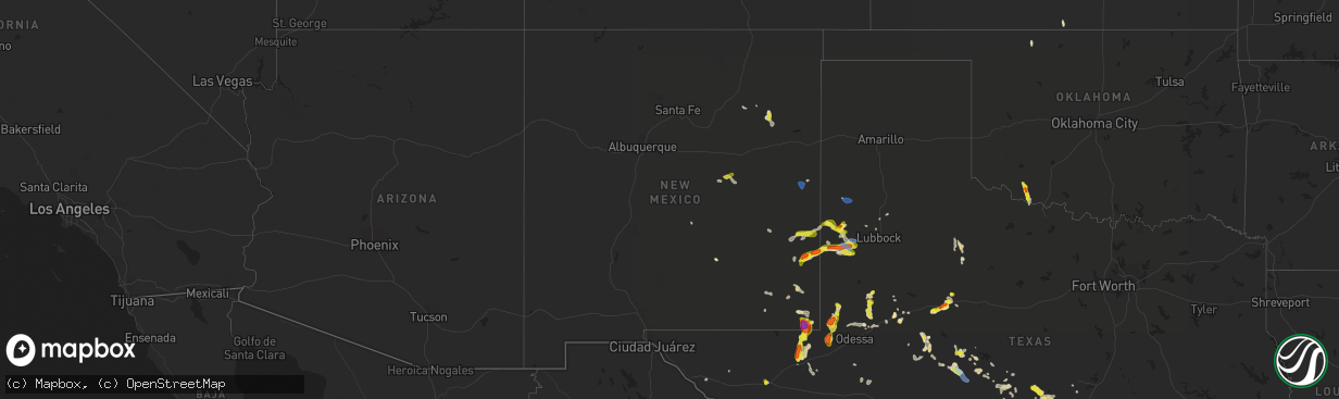
Hail Map in New Mexico on June 2, 2021
The weather event in New Mexico on June 2, 2021 includes Hail, Wind, and Tornado maps. 10 states and 190 cities were impacted and suffered possible damage. The total estimated number of properties impacted is 883.
Want more than just the map?
Turn this storm into a full workflow.
- Owner + property data so you know who to knock
- OnDemand branded weather history reports to win the "did we even have hail?" argument
- RoofTrace estimate so reps stop guessing numbers at the door
Bought this map? Upgrade within 7 days and we'll credit the $230. (10-15 min setup call)
Hail
Wind
Tornado
883
Estimated number of impacted properties by a 1.00" hail or larger685
Estimated number of impacted properties by a 1.75" hail or larger4
Estimated number of impacted properties by a 2.50" hail or largerStorm reports in New Mexico
New Mexico
| Date | Description |
|---|---|
| 06/02/20216:53 PM CDT | Ktcc asos. |
| 06/02/20213:31 PM CDT | Brief landspout spotted near rainsville. |
| 06/02/20218:02 AM CDT | A local report indicates 1.75 inch wind near TATUM |
| 06/02/20212:58 AM CDT | At 758 PM MDT, a severe thunderstorm was located near Milnesand, or 27 miles north of Tatum, moving northeast at 30 mph. HAZARD...60 mph wind gusts and half dollar size hail. SOURCE...Radar indicated. IMPACT...Hail damage to vehicles is expected. Expect wind damage to roofs, siding, and trees. Locations impacted include... Causey, Milnesand, Lingo and Pep. |
| 06/02/20212:14 AM CDT | At 714 PM MDT, a severe thunderstorm was located 7 miles northeast of Tatum, moving northeast at 15 mph. HAZARD...Golf ball size hail and 60 mph wind gusts. SOURCE...Trained weather spotters. IMPACT...People and animals outdoors will be injured. Expect hail damage to roofs, siding, windows, and vehicles. Expect wind damage to roofs, siding, and trees. Locations impacted include... Gladiola. |
| 06/02/20212:12 AM CDT | At 712 PM CDT/612 PM MDT/, a severe thunderstorm was located near Jal, moving east at 10 mph. HAZARD...60 mph wind gusts and quarter size hail. SOURCE...Radar indicated. IMPACT...Hail damage to vehicles is expected. Expect wind damage to roofs, siding, and trees. Locations impacted include... Jal, Jal Airport and Bennett. |
| 06/02/20211:34 AM CDT | At 633 PM MDT, a severe thunderstorm was located over Elkins, or 33 miles northeast of Roswell, moving southeast at 5 mph. HAZARD...60 mph wind gusts and half dollar size hail. SOURCE...Radar indicated. IMPACT...Hail damage to vehicles is expected. Expect wind damage to roofs, siding, and trees. Locations impacted include... Elkins and along U.S Highway 70 between mile markers 364 and 370. |
| 06/02/20211:24 AM CDT | At 624 PM MDT, a severe thunderstorm was located near Saint Vrain, or 14 miles northwest of Clovis, moving southeast at 15 mph. HAZARD...60 mph wind gusts and half dollar size hail. SOURCE...Radar indicated. IMPACT...Hail damage to vehicles is expected. Expect wind damage to roofs, siding, and trees. Locations impacted include... Clovis, Portales, Melrose, Floyd, Saint Vrain, Cannon Air Force Base, Ranchvale, Oasis State Park and Portair.This includes Highway 60 between Mile Markers 363 and 395. |
| 06/02/202112:43 AM CDT | At 543 PM MDT, a severe thunderstorm was located 16 miles northeast of Avalon, or 20 miles northeast of Carlsbad, moving east at 25 mph. HAZARD...60 mph wind gusts and half dollar size hail. SOURCE...Radar indicated. IMPACT...Hail damage to vehicles is expected. Expect wind damage to roofs, siding, and trees. Locations impacted include... Halfway. |
| 06/01/202111:58 PM CDT | At 458 PM CDT/358 PM MDT/, a severe thunderstorm was located 14 miles northwest of Goldsmith, or 17 miles southwest of Andrews, moving south at 15 mph. HAZARD...Ping pong ball size hail and 60 mph wind gusts. SOURCE...Radar indicated. IMPACT...People and animals outdoors will be injured. Expect hail damage to roofs, siding, windows, and vehicles. Expect wind damage to roofs, siding, and trees. Locations impacted include... Kermit, Goldsmith, West Odessa and Notrees. |
| 06/01/202111:22 PM CDT | At 421 PM MDT, a severe thunderstorm was located 11 miles northeast of Conchas Dam, or 16 miles southwest of Mosquero, moving south at 20 mph. HAZARD...60 mph wind gusts and quarter size hail. SOURCE...Radar indicated. IMPACT...Hail damage to vehicles is expected. Expect wind damage to roofs, siding, and trees. Locations impacted include... Conchas Dam, Conchas, Conchas Lake State Park and Bell Ranch. This includes State Road 104 between Mile Markers 68 and 91. |
| 06/01/202111:18 PM CDT | At 418 PM MDT, a severe thunderstorm was located near Montoya, or 23 miles southwest of Tucumcari, moving northeast at 5 mph. HAZARD...60 mph wind gusts and quarter size hail. SOURCE...Radar indicated. IMPACT...Hail damage to vehicles is expected. Expect wind damage to roofs, siding, and trees. Locations impacted include... Montoya.This includes Interstate 40 between Mile Markers 308 and 321. |
| 06/01/202110:59 PM CDT | At 359 PM MDT, a severe thunderstorm was located 12 miles south of Pastura, or 16 miles east of Vaughn, moving northeast at 20 mph. HAZARD...Ping pong ball size hail and 60 mph wind gusts. SOURCE...Radar indicated. IMPACT...People and animals outdoors will be injured. Expect hail damage to roofs, siding, windows, and vehicles. Expect wind damage to roofs, siding, and trees. Locations impacted include... Puerto De Luna and Yeso. This includes Highway 60 between Mile Markers 281 and 305. |
| 06/01/202110:34 PM CDT | At 333 PM MDT, a severe thunderstorm was located 10 miles southeast of Vaughn, moving northeast at 20 mph. HAZARD...60 mph wind gusts and quarter size hail. SOURCE...Radar indicated. IMPACT...Hail damage to vehicles is expected. Expect wind damage to roofs, siding, and trees. This severe thunderstorm will remain over mainly rural areas of west central De Baca and southwestern Guadalupe Counties.This includes the following highways... Highway 285 between Mile Markers 184 and 201. Highway 60 between Mile Markers 273 and 294. |
| 06/01/20218:02 PM CDT | A local report indicates 1.75 inch wind near TATUM |
| 06/01/20218:00 PM CDT | A local report indicates 62 MPH wind near 14 WSW JAL |
| 06/01/20217:39 PM CDT | A local report indicates 1.00 inch wind near 1 SW TATUM |
All States Impacted by Hail Map on June 2, 2021
Cities Impacted by Hail Map on June 2, 2021
- Cadiz, KY
- Garden Plain, KS
- Sterling City, TX
- Stanton, TX
- Midland, TX
- Spicewood, TX
- Marble Falls, TX
- Roscoe, TX
- Anthony, KS
- Artesia, NM
- Lincoln, TX
- Lexington, TX
- Russellville, AL
- Davidson, OK
- Frederick, OK
- Hollister, OK
- Loraine, TX
- Colorado City, TX
- Sweetwater, TX
- Paint Rock, TX
- Pyote, TX
- Van Horn, TX
- Meadow, TX
- Plains, TX
- Pecos, TX
- Mentone, TX
- Conchas Dam, NM
- Alva, OK
- Eden, TX
- Camden, TN
- Lamesa, TX
- Llano, TX
- Hempstead, TX
- Sealy, TX
- Bellville, TX
- Chappell Hill, TX
- Brookshire, TX
- Brenham, TX
- Carlsbad, TX
- Fort Davis, TX
- Big Spring, TX
- Phil Campbell, AL
- Mertzon, TX
- Caldwell, TX
- Cherokee, TX
- Tow, TX
- San Saba, TX
- Burnet, TX
- Jal, NM
- Elkmont, AL
- Lester, AL
- Kermit, TX
- Holladay, TN
- Coahoma, TX
- Voca, TX
- Fredonia, TX
- Andrews, TX
- Morton, TX
- Tatum, NM
- Milnesand, NM
- Elida, NM
- Abernathy, TX
- Old Glory, TX
- Aspermont, TX
- Sundown, TX
- Whiteface, TX
- Levelland, TX
- Barstow, TX
- Tinnie, NM
- Lovington, NM
- San Angelo, TX
- Electra, TX
- Grandfield, OK
- Brady, TX
- Goldsmith, TX
- Lubbock, TX
- Splendora, TX
- Porter, TX
- New Caney, TX
- Leander, TX
- Austin, TX
- Bertram, TX
- Bluffton, TX
- Kingsland, TX
- Buchanan Dam, TX
- Sierra Blanca, TX
- Miles, TX
- Petersburg, TX
- Wink, TX
- Gail, TX
- Baytown, TX
- Channelview, TX
- Highlands, TX
- Red Bay, AL
- Vina, AL
- Ropesville, TX
- Pep, TX
- Ballinger, TX
- McCamey, TX
- Orange, TX
- Silver Lake, OR
- Roswell, NM
- Guin, AL
- Sulligent, AL
- Vernon, AL
- Winfield, AL
- Beaverton, AL
- Muscle Shoals, AL
- Town Creek, AL
- Rogersville, AL
- Killen, AL
- Anton, TX
- Vaughn, NM
- Vancourt, TX
- Melvin, TX
- Tucumcari, NM
- Indian Mound, TN
- Woodlawn, TN
- Edcouch, TX
- Elsa, TX
- Weir, MS
- Mason, TX
- Bruceton, TN
- Hollow Rock, TN
- Westport, TN
- Sugar Tree, TN
- Yuma, TN
- Hurricane Mills, TN
- Waverly, TN
- Wildersville, TN
- Art, TX
- Houston, TX
- Dover, TN
- Sugar Land, TX
- Sudan, TX
- Springville, TN
- Mansfield, TN
- Buena Vista, TN
- Millport, AL
- Rochelle, TX
- Richland Springs, TX
- Clovis, NM
- Carlsbad, NM
- Tarzan, TX
- Kempner, TX
- New Johnsonville, TN
- Roby, TX
- Briggs, TX
- Culleoka, TN
- Lewisburg, TN
- Yeso, NM
- Paducah, TX
- Hobbs, NM
- Tokio, TX
- Huntingdon, TN
- Cherokee, AL
- Golden, MS
- Tuscumbia, AL
- Bellaire, TX
- Stafford, TX
- Paris, TN
- Liberty Hill, TX
- Breckenridge, TX
- Crane, TX
- Bronte, TX
- Anderson, AL
- Leighton, AL
- Georgetown, TX
- Hutto, TX
- Round Rock, TX
- Dime Box, TX
- Carrizozo, NM
- Kingwood, TX
- Murray, KY
- Trementina, NM
- Columbus, MS
- Ethelsville, AL
- Steens, MS
- Waldron, KS
- Doole, TX
- Pep, NM
- Melrose, NM
- Teachey, NC
- Wallace, NC
- Willard, NC
- Rose Hill, NC
- Whiteville, NC
- Flowood, MS
- Maple, TX
- Earth, TX


