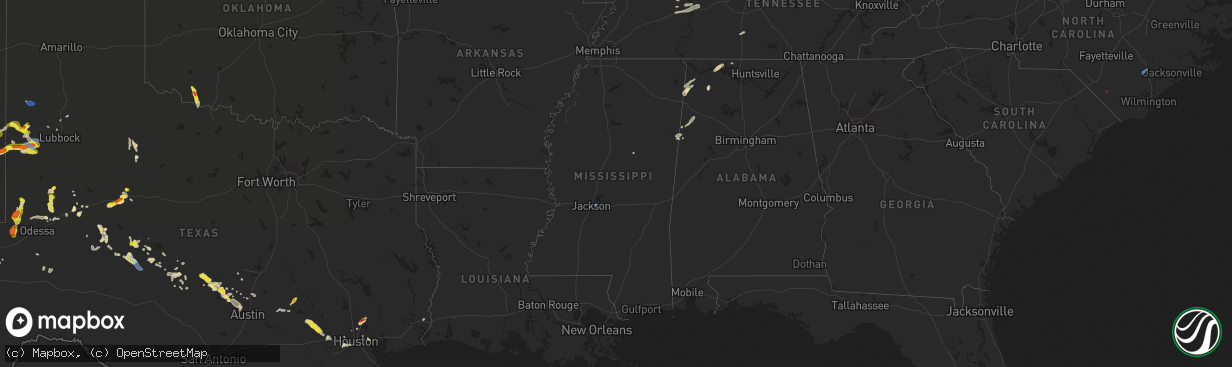
Hail Map in Mississippi on June 2, 2021
The weather event in Mississippi on June 2, 2021 includes Hail, Wind, and Tornado maps. 10 states and 190 cities were impacted and suffered possible damage. The total estimated number of properties impacted is 0.
Want more than just the map?
Turn this storm into a full workflow.
- Owner + property data so you know who to knock
- OnDemand branded weather history reports to win the "did we even have hail?" argument
- RoofTrace estimate so reps stop guessing numbers at the door
Bought this map? Upgrade within 7 days and we'll credit the $230. (10-15 min setup call)
Hail
Wind
Tornado
0
Estimated number of impacted properties by a 1.00" hail or larger0
Estimated number of impacted properties by a 1.75" hail or larger0
Estimated number of impacted properties by a 2.50" hail or largerStorm reports in Mississippi
Mississippi
| Date | Description |
|---|---|
| 06/02/20214:05 PM CDT | Corrects previous tstm wnd gst report from jan airport. Actual non-rounded peak gust was 74 mph. Measured by kjan. |
| 06/02/20214:01 PM CDT | Measured by kjan. |
| 06/02/202112:24 AM CDT | At 523 PM CDT, a severe thunderstorm was located near Renfroe, or near Carthage, moving northeast at 25 mph. HAZARD...60 mph wind gusts. SOURCE...Radar indicated. IMPACT...Expect damage to roofs, siding, and trees. This severe thunderstorm will be near... Renfroe around 530 PM CDT. |
| 06/01/202111:52 PM CDT | At 452 PM CDT, a severe thunderstorm was located near Tuscola, or 7 miles northwest of Harperville, moving northeast at 35 mph. HAZARD...60 mph wind gusts. SOURCE...Radar indicated. IMPACT...Expect damage to roofs, siding, and trees. This severe thunderstorm will be near... Tuscola around 500 PM CDT. Madden around 520 PM CDT. Edinburg around 530 PM CDT.Other locations impacted by this severe thunderstorm include Lena,Standing Pine and Walnut Grove. |
| 06/01/202111:37 PM CDT | At 437 PM CDT, a severe thunderstorm was located over Leesburg, or 9 miles northwest of Morton, moving northeast at 25 mph. HAZARD...60 mph wind gusts. SOURCE...Radar indicated. IMPACT...Expect damage to roofs, siding, and trees. This severe thunderstorm will be near... Branch around 440 PM CDT. Forkville around 450 PM CDT. Ludlow around 455 PM CDT. Harperville around 510 PM CDT.Other locations impacted by this severe thunderstorm includeSebastopol. |
| 06/01/202111:01 PM CDT | At 401 PM CDT, a severe thunderstorm was located near Flowood, moving northeast at 30 mph. HAZARD...60 mph wind gusts. SOURCE...Radar indicated. IMPACT...Expect damage to roofs, siding, and trees. This severe thunderstorm will be near... Fannin around 415 PM CDT. Goshen Springs around 425 PM CDT. Pisgah around 430 PM CDT. Leesburg around 435 PM CDT. |
| 06/01/202110:14 PM CDT | At 314 PM CDT, a severe thunderstorm was located near Red Bay, moving north at 30 mph. HAZARD...60 mph wind gusts and quarter size hail. SOURCE...Radar indicated. IMPACT...Hail damage to vehicles is expected. Expect wind damage to roofs, siding, and trees. Locations impacted include... Red Bay, Cherokee, Vina, Posey Loop, Pogo, Mt Hester, Cedar Creek Reservoir, Atwood, Srygley Church and Maud. |
All States Impacted by Hail Map on June 2, 2021
Cities Impacted by Hail Map on June 2, 2021
- Cadiz, KY
- Garden Plain, KS
- Sterling City, TX
- Stanton, TX
- Midland, TX
- Spicewood, TX
- Marble Falls, TX
- Roscoe, TX
- Anthony, KS
- Artesia, NM
- Lincoln, TX
- Lexington, TX
- Russellville, AL
- Davidson, OK
- Frederick, OK
- Hollister, OK
- Loraine, TX
- Colorado City, TX
- Sweetwater, TX
- Paint Rock, TX
- Pyote, TX
- Van Horn, TX
- Meadow, TX
- Plains, TX
- Pecos, TX
- Mentone, TX
- Conchas Dam, NM
- Alva, OK
- Eden, TX
- Camden, TN
- Lamesa, TX
- Llano, TX
- Hempstead, TX
- Sealy, TX
- Bellville, TX
- Chappell Hill, TX
- Brookshire, TX
- Brenham, TX
- Carlsbad, TX
- Fort Davis, TX
- Big Spring, TX
- Phil Campbell, AL
- Mertzon, TX
- Caldwell, TX
- Cherokee, TX
- Tow, TX
- San Saba, TX
- Burnet, TX
- Jal, NM
- Elkmont, AL
- Lester, AL
- Kermit, TX
- Holladay, TN
- Coahoma, TX
- Voca, TX
- Fredonia, TX
- Andrews, TX
- Morton, TX
- Tatum, NM
- Milnesand, NM
- Elida, NM
- Abernathy, TX
- Old Glory, TX
- Aspermont, TX
- Sundown, TX
- Whiteface, TX
- Levelland, TX
- Barstow, TX
- Tinnie, NM
- Lovington, NM
- San Angelo, TX
- Electra, TX
- Grandfield, OK
- Brady, TX
- Goldsmith, TX
- Lubbock, TX
- Splendora, TX
- Porter, TX
- New Caney, TX
- Leander, TX
- Austin, TX
- Bertram, TX
- Bluffton, TX
- Kingsland, TX
- Buchanan Dam, TX
- Sierra Blanca, TX
- Miles, TX
- Petersburg, TX
- Wink, TX
- Gail, TX
- Baytown, TX
- Channelview, TX
- Highlands, TX
- Red Bay, AL
- Vina, AL
- Ropesville, TX
- Pep, TX
- Ballinger, TX
- McCamey, TX
- Orange, TX
- Silver Lake, OR
- Roswell, NM
- Guin, AL
- Sulligent, AL
- Vernon, AL
- Winfield, AL
- Beaverton, AL
- Muscle Shoals, AL
- Town Creek, AL
- Rogersville, AL
- Killen, AL
- Anton, TX
- Vaughn, NM
- Vancourt, TX
- Melvin, TX
- Tucumcari, NM
- Indian Mound, TN
- Woodlawn, TN
- Edcouch, TX
- Elsa, TX
- Weir, MS
- Mason, TX
- Bruceton, TN
- Hollow Rock, TN
- Westport, TN
- Sugar Tree, TN
- Yuma, TN
- Hurricane Mills, TN
- Waverly, TN
- Wildersville, TN
- Art, TX
- Houston, TX
- Dover, TN
- Sugar Land, TX
- Sudan, TX
- Springville, TN
- Mansfield, TN
- Buena Vista, TN
- Millport, AL
- Rochelle, TX
- Richland Springs, TX
- Clovis, NM
- Carlsbad, NM
- Tarzan, TX
- Kempner, TX
- New Johnsonville, TN
- Roby, TX
- Briggs, TX
- Culleoka, TN
- Lewisburg, TN
- Yeso, NM
- Paducah, TX
- Hobbs, NM
- Tokio, TX
- Huntingdon, TN
- Cherokee, AL
- Golden, MS
- Tuscumbia, AL
- Bellaire, TX
- Stafford, TX
- Paris, TN
- Liberty Hill, TX
- Breckenridge, TX
- Crane, TX
- Bronte, TX
- Anderson, AL
- Leighton, AL
- Georgetown, TX
- Hutto, TX
- Round Rock, TX
- Dime Box, TX
- Carrizozo, NM
- Kingwood, TX
- Murray, KY
- Trementina, NM
- Columbus, MS
- Ethelsville, AL
- Steens, MS
- Waldron, KS
- Doole, TX
- Pep, NM
- Melrose, NM
- Teachey, NC
- Wallace, NC
- Willard, NC
- Rose Hill, NC
- Whiteville, NC
- Flowood, MS
- Maple, TX
- Earth, TX


