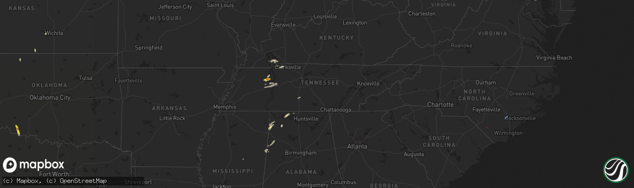
Hail Map in Tennessee on June 2, 2021
The weather event in Tennessee on June 2, 2021 includes Hail, Wind, and Tornado maps. 10 states and 190 cities were impacted and suffered possible damage. The total estimated number of properties impacted is 862.
Want more than just the map?
Turn this storm into a full workflow.
- Owner + property data so you know who to knock
- OnDemand branded weather history reports to win the "did we even have hail?" argument
- RoofTrace estimate so reps stop guessing numbers at the door
Bought this map? Upgrade within 7 days and we'll credit the $230. (10-15 min setup call)
Hail
Wind
Tornado
862
Estimated number of impacted properties by a 1.00" hail or larger83
Estimated number of impacted properties by a 1.75" hail or larger0
Estimated number of impacted properties by a 2.50" hail or largerStorm reports in Tennessee
Tennessee
| Date | Description |
|---|---|
| 06/02/20214:15 PM CDT | Quarter size hail along highway 651 north of camden. |
| 06/02/20214:07 PM CDT | Half dollar size hail reported along cedar grove church road and sawmill road. |
| 06/02/20213:51 AM CDT | At 850 PM CDT, a severe thunderstorm was located over Hurricane Mills, or 8 miles south of Waverly, moving northeast at 25 mph. HAZARD...60 mph wind gusts and penny size hail. SOURCE...Radar indicated. IMPACT...Expect damage to roofs, siding, and trees. Locations impacted include... McEwen, Hurricane Mills, Pinewood and Bucksnort. This includes Interstate 40 between mile markers 143 and 169. |
| 06/02/20213:35 AM CDT | At 835 PM CDT, a severe thunderstorm was located near Waverly, moving east at 25 mph. HAZARD...60 mph wind gusts and penny size hail. SOURCE...Radar indicated. IMPACT...Expect damage to roofs, siding, and trees. Locations impacted include... Waverly and McEwen. |
| 06/01/202111:02 PM CDT | At 401 PM CDT, a severe thunderstorm was located near Vale, or 9 miles west of Camden, moving east at 20 mph. HAZARD...60 mph wind gusts and quarter size hail. SOURCE...Radar indicated. IMPACT...Hail damage to vehicles is expected. Expect wind damage to roofs, siding, and trees. Locations impacted include... Camden, Bruceton, Vale, Hollow Rock, Mansfield, Ephesus and Nathan Bedford Forrest State Park. |
| 06/01/202110:50 PM CDT | At 349 PM CDT, a severe thunderstorm was located near Lewisburg, moving northeast at 25 mph. HAZARD...60 mph wind gusts and quarter size hail. SOURCE...Radar indicated. IMPACT...Hail damage to vehicles is expected. Expect wind damage to roofs, siding, and trees. Locations impacted include... Lewisburg, Chapel Hill and Farmington. This includes Interstate 65 between mile markers 32 and 34. |
| 06/01/20219:17 PM CDT | Tv footage shows several transformer explosions resulting in widespread power outage |
| 06/01/20219:15 PM CDT | A few trees were blown down in clarksville including one that fell into a house at glenwood drive at madison street |
| 06/01/20218:35 PM CDT | Report of an unanchored... 40 ft mobile home blown off blocks at dry branch rd and morgan creek rd. |
All States Impacted by Hail Map on June 2, 2021
Cities Impacted by Hail Map on June 2, 2021
- Cadiz, KY
- Garden Plain, KS
- Sterling City, TX
- Stanton, TX
- Midland, TX
- Spicewood, TX
- Marble Falls, TX
- Roscoe, TX
- Anthony, KS
- Artesia, NM
- Lincoln, TX
- Lexington, TX
- Russellville, AL
- Davidson, OK
- Frederick, OK
- Hollister, OK
- Loraine, TX
- Colorado City, TX
- Sweetwater, TX
- Paint Rock, TX
- Pyote, TX
- Van Horn, TX
- Meadow, TX
- Plains, TX
- Pecos, TX
- Mentone, TX
- Conchas Dam, NM
- Alva, OK
- Eden, TX
- Camden, TN
- Lamesa, TX
- Llano, TX
- Hempstead, TX
- Sealy, TX
- Bellville, TX
- Chappell Hill, TX
- Brookshire, TX
- Brenham, TX
- Carlsbad, TX
- Fort Davis, TX
- Big Spring, TX
- Phil Campbell, AL
- Mertzon, TX
- Caldwell, TX
- Cherokee, TX
- Tow, TX
- San Saba, TX
- Burnet, TX
- Jal, NM
- Elkmont, AL
- Lester, AL
- Kermit, TX
- Holladay, TN
- Coahoma, TX
- Voca, TX
- Fredonia, TX
- Andrews, TX
- Morton, TX
- Tatum, NM
- Milnesand, NM
- Elida, NM
- Abernathy, TX
- Old Glory, TX
- Aspermont, TX
- Sundown, TX
- Whiteface, TX
- Levelland, TX
- Barstow, TX
- Tinnie, NM
- Lovington, NM
- San Angelo, TX
- Electra, TX
- Grandfield, OK
- Brady, TX
- Goldsmith, TX
- Lubbock, TX
- Splendora, TX
- Porter, TX
- New Caney, TX
- Leander, TX
- Austin, TX
- Bertram, TX
- Bluffton, TX
- Kingsland, TX
- Buchanan Dam, TX
- Sierra Blanca, TX
- Miles, TX
- Petersburg, TX
- Wink, TX
- Gail, TX
- Baytown, TX
- Channelview, TX
- Highlands, TX
- Red Bay, AL
- Vina, AL
- Ropesville, TX
- Pep, TX
- Ballinger, TX
- McCamey, TX
- Orange, TX
- Silver Lake, OR
- Roswell, NM
- Guin, AL
- Sulligent, AL
- Vernon, AL
- Winfield, AL
- Beaverton, AL
- Muscle Shoals, AL
- Town Creek, AL
- Rogersville, AL
- Killen, AL
- Anton, TX
- Vaughn, NM
- Vancourt, TX
- Melvin, TX
- Tucumcari, NM
- Indian Mound, TN
- Woodlawn, TN
- Edcouch, TX
- Elsa, TX
- Weir, MS
- Mason, TX
- Bruceton, TN
- Hollow Rock, TN
- Westport, TN
- Sugar Tree, TN
- Yuma, TN
- Hurricane Mills, TN
- Waverly, TN
- Wildersville, TN
- Art, TX
- Houston, TX
- Dover, TN
- Sugar Land, TX
- Sudan, TX
- Springville, TN
- Mansfield, TN
- Buena Vista, TN
- Millport, AL
- Rochelle, TX
- Richland Springs, TX
- Clovis, NM
- Carlsbad, NM
- Tarzan, TX
- Kempner, TX
- New Johnsonville, TN
- Roby, TX
- Briggs, TX
- Culleoka, TN
- Lewisburg, TN
- Yeso, NM
- Paducah, TX
- Hobbs, NM
- Tokio, TX
- Huntingdon, TN
- Cherokee, AL
- Golden, MS
- Tuscumbia, AL
- Bellaire, TX
- Stafford, TX
- Paris, TN
- Liberty Hill, TX
- Breckenridge, TX
- Crane, TX
- Bronte, TX
- Anderson, AL
- Leighton, AL
- Georgetown, TX
- Hutto, TX
- Round Rock, TX
- Dime Box, TX
- Carrizozo, NM
- Kingwood, TX
- Murray, KY
- Trementina, NM
- Columbus, MS
- Ethelsville, AL
- Steens, MS
- Waldron, KS
- Doole, TX
- Pep, NM
- Melrose, NM
- Teachey, NC
- Wallace, NC
- Willard, NC
- Rose Hill, NC
- Whiteville, NC
- Flowood, MS
- Maple, TX
- Earth, TX


