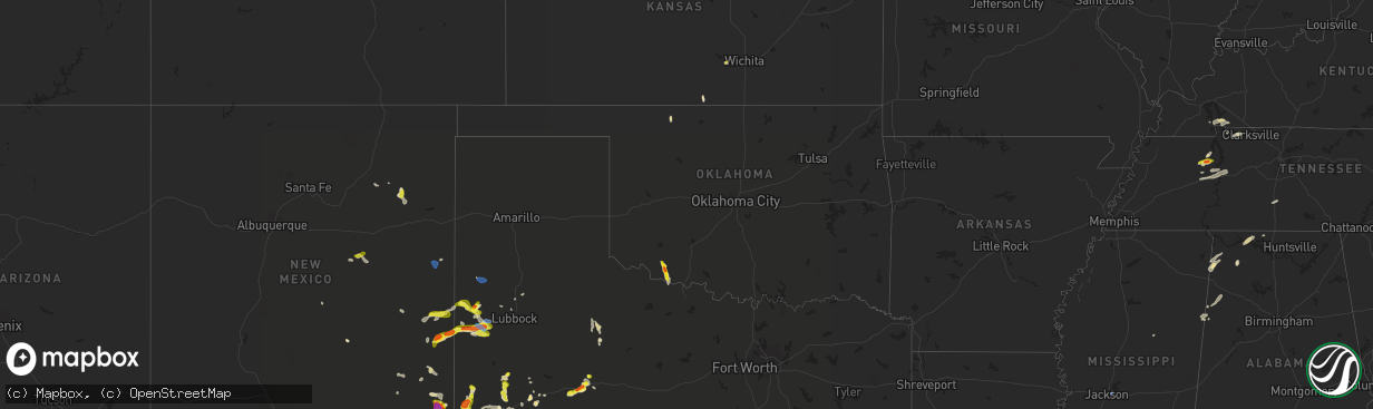
Hail Map in Oklahoma on June 2, 2021
The weather event in Oklahoma on June 2, 2021 includes Hail, Wind, and Tornado maps. 10 states and 190 cities were impacted and suffered possible damage. The total estimated number of properties impacted is 104.
Want more than just the map?
Turn this storm into a full workflow.
- Owner + property data so you know who to knock
- OnDemand branded weather history reports to win the "did we even have hail?" argument
- RoofTrace estimate so reps stop guessing numbers at the door
Bought this map? Upgrade within 7 days and we'll credit the $230. (10-15 min setup call)
Hail
Wind
Tornado
104
Estimated number of impacted properties by a 1.00" hail or larger59
Estimated number of impacted properties by a 1.75" hail or larger0
Estimated number of impacted properties by a 2.50" hail or largerStorm reports in Oklahoma
Oklahoma
| Date | Description |
|---|---|
| 06/02/20213:55 PM CDT | A local report indicates 1.75 inch wind near HOLLISTER |
| 06/01/202111:08 PM CDT | At 408 PM CDT, a severe thunderstorm was located 4 miles southwest of Loveland, moving south at 20 mph. HAZARD...Golf ball size hail and 70 mph wind gusts. SOURCE...Trained weather spotters. IMPACT...People and animals outdoors will be injured. Expect hail damage to roofs, siding, windows, and vehicles. Expect considerable tree damage. Wind damage is also likely to mobile homes, roofs, and outbuildings. Locations impacted include... Burkburnett, Electra, Grandfield, Loveland and Haynesville. |
| 06/01/202110:35 PM CDT | At 334 PM CDT, a severe thunderstorm was located 5 miles west of Alva, moving south at 10 mph. HAZARD...60 mph wind gusts and quarter size hail. SOURCE...Radar indicated. IMPACT...Hail damage to vehicles is expected. Expect wind damage to roofs, siding, and trees. Locations impacted include... Alva, Waynoka, Avard and Hopeton. |
| 06/01/202110:24 PM CDT | At 324 PM CDT, a severe thunderstorm was located 5 miles southeast of Manitou, moving southeast at 15 mph. HAZARD...60 mph wind gusts and quarter size hail. SOURCE...Radar indicated. IMPACT...Hail damage to vehicles is expected. Expect wind damage to roofs, siding, and trees. Locations impacted include... Manitou, Hollister and Loveland. |
All States Impacted by Hail Map on June 2, 2021
Cities Impacted by Hail Map on June 2, 2021
- Cadiz, KY
- Garden Plain, KS
- Sterling City, TX
- Stanton, TX
- Midland, TX
- Spicewood, TX
- Marble Falls, TX
- Roscoe, TX
- Anthony, KS
- Artesia, NM
- Lincoln, TX
- Lexington, TX
- Russellville, AL
- Davidson, OK
- Frederick, OK
- Hollister, OK
- Loraine, TX
- Colorado City, TX
- Sweetwater, TX
- Paint Rock, TX
- Pyote, TX
- Van Horn, TX
- Meadow, TX
- Plains, TX
- Pecos, TX
- Mentone, TX
- Conchas Dam, NM
- Alva, OK
- Eden, TX
- Camden, TN
- Lamesa, TX
- Llano, TX
- Hempstead, TX
- Sealy, TX
- Bellville, TX
- Chappell Hill, TX
- Brookshire, TX
- Brenham, TX
- Carlsbad, TX
- Fort Davis, TX
- Big Spring, TX
- Phil Campbell, AL
- Mertzon, TX
- Caldwell, TX
- Cherokee, TX
- Tow, TX
- San Saba, TX
- Burnet, TX
- Jal, NM
- Elkmont, AL
- Lester, AL
- Kermit, TX
- Holladay, TN
- Coahoma, TX
- Voca, TX
- Fredonia, TX
- Andrews, TX
- Morton, TX
- Tatum, NM
- Milnesand, NM
- Elida, NM
- Abernathy, TX
- Old Glory, TX
- Aspermont, TX
- Sundown, TX
- Whiteface, TX
- Levelland, TX
- Barstow, TX
- Tinnie, NM
- Lovington, NM
- San Angelo, TX
- Electra, TX
- Grandfield, OK
- Brady, TX
- Goldsmith, TX
- Lubbock, TX
- Splendora, TX
- Porter, TX
- New Caney, TX
- Leander, TX
- Austin, TX
- Bertram, TX
- Bluffton, TX
- Kingsland, TX
- Buchanan Dam, TX
- Sierra Blanca, TX
- Miles, TX
- Petersburg, TX
- Wink, TX
- Gail, TX
- Baytown, TX
- Channelview, TX
- Highlands, TX
- Red Bay, AL
- Vina, AL
- Ropesville, TX
- Pep, TX
- Ballinger, TX
- McCamey, TX
- Orange, TX
- Silver Lake, OR
- Roswell, NM
- Guin, AL
- Sulligent, AL
- Vernon, AL
- Winfield, AL
- Beaverton, AL
- Muscle Shoals, AL
- Town Creek, AL
- Rogersville, AL
- Killen, AL
- Anton, TX
- Vaughn, NM
- Vancourt, TX
- Melvin, TX
- Tucumcari, NM
- Indian Mound, TN
- Woodlawn, TN
- Edcouch, TX
- Elsa, TX
- Weir, MS
- Mason, TX
- Bruceton, TN
- Hollow Rock, TN
- Westport, TN
- Sugar Tree, TN
- Yuma, TN
- Hurricane Mills, TN
- Waverly, TN
- Wildersville, TN
- Art, TX
- Houston, TX
- Dover, TN
- Sugar Land, TX
- Sudan, TX
- Springville, TN
- Mansfield, TN
- Buena Vista, TN
- Millport, AL
- Rochelle, TX
- Richland Springs, TX
- Clovis, NM
- Carlsbad, NM
- Tarzan, TX
- Kempner, TX
- New Johnsonville, TN
- Roby, TX
- Briggs, TX
- Culleoka, TN
- Lewisburg, TN
- Yeso, NM
- Paducah, TX
- Hobbs, NM
- Tokio, TX
- Huntingdon, TN
- Cherokee, AL
- Golden, MS
- Tuscumbia, AL
- Bellaire, TX
- Stafford, TX
- Paris, TN
- Liberty Hill, TX
- Breckenridge, TX
- Crane, TX
- Bronte, TX
- Anderson, AL
- Leighton, AL
- Georgetown, TX
- Hutto, TX
- Round Rock, TX
- Dime Box, TX
- Carrizozo, NM
- Kingwood, TX
- Murray, KY
- Trementina, NM
- Columbus, MS
- Ethelsville, AL
- Steens, MS
- Waldron, KS
- Doole, TX
- Pep, NM
- Melrose, NM
- Teachey, NC
- Wallace, NC
- Willard, NC
- Rose Hill, NC
- Whiteville, NC
- Flowood, MS
- Maple, TX
- Earth, TX


