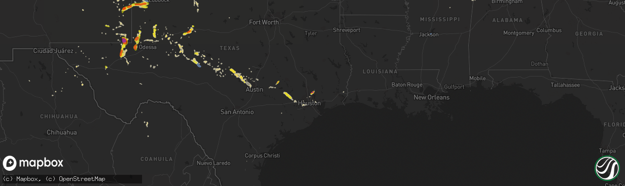
Hail Map on June 2, 2021
The weather event on June 2, 2021 includes Hail, Wind, and Tornado maps. 10 states and 190 cities were impacted and suffered possible damage. The total estimated number of properties impacted is 22,970.
Want more than just the map?
Turn this storm into a full workflow.
- Owner + property data so you know who to knock
- OnDemand branded weather history reports to win the "did we even have hail?" argument
- RoofTrace estimate so reps stop guessing numbers at the door
Bought this map? Upgrade within 7 days and we'll credit the $230. (10-15 min setup call)
Hail
Wind
Tornado
22,970
Estimated number of impacted properties by a 1.00" hail or larger6,572
Estimated number of impacted properties by a 1.75" hail or larger4
Estimated number of impacted properties by a 2.50" hail or largerStates Impacted by Hail Map on June 2, 2021
Storm reports
Maryland
| Date | Description |
|---|---|
| 06/02/20216:10 PM CDT | A couple trees reported down in the oldtown area |
| 06/02/20215:05 PM CDT | Multiple trees and power lines reported down between westernport and mccoole |
| 06/02/20211:27 AM CDT | At 627 PM EDT, a severe thunderstorm was located near Fort Ashby, or 7 miles east of Keyser, moving east at 20 mph. HAZARD...60 mph wind gusts and quarter size hail. SOURCE...Radar indicated. IMPACT...Damaging winds will cause some trees and large branches to fall. This could injure those outdoors, as well as damage homes and vehicles. Roadways may become blocked by downed trees. Localized power outages are possible. Unsecured light objects may become projectiles. Locations impacted include... Fort Ashby, Springfield, Green Spring, Oldtown, Spring Gap, Reeses Mill, Points, Patterson Creek, Higginsville and Wagoner. |
West Virginia
| Date | Description |
|---|---|
| 06/02/20215:24 PM CDT | Tree down near the intersection of carroll avenue and vernon street |
| 06/02/20215:20 PM CDT | Large tree and powerlines down on house on 100 block of front street |
| 06/02/20215:19 PM CDT | Tree down on the 300 block of west piedmont street |
| 06/02/20215:00 PM CDT | Trained spotter confirmed trees & wires down per county police scanner. |
| 06/02/20211:00 AM CDT | At 600 PM EDT, a severe thunderstorm was located near Keyser, moving east at 15 mph. HAZARD...60 mph wind gusts and quarter size hail. SOURCE...Radar indicated. IMPACT...Damaging winds will cause some trees and large branches to fall. This could injure those outdoors, as well as damage homes and vehicles. Roadways may become blocked by downed trees. Localized power outages are possible. Unsecured light objects may become projectiles. Locations impacted include... Keyser, Westernport, Bel Air, Piedmont, Cresaptown, Rawlings, Luke, Mccoole, Reeses Mill and Warnocks. |
Arkansas
| Date | Description |
|---|---|
| 06/02/20212:01 PM CDT | Video of a brief landspout tornado over an open field near highway 158 west of luxora. |
North Carolina
| Date | Description |
|---|---|
| 06/02/20214:25 PM CDT | Video shared with a local broadcast meteorologist showed a tornado on the ground with debris in the air. Time estimated. |
| 06/02/20214:05 PM CDT | Widespread trees down between teachey and wallace. Tree fell on tractor trailer on us 117. Time estimated by radar. |
| 06/02/20213:59 PM CDT | Duplin county law enforement reported a tornado on the ground near the junction of highway 41 and cornwallis rd. |
| 06/01/20218:04 PM CDT | Brief tornado touched down south of abbottsburg with minor tree damage observed. View pns for additional information. |
Mississippi
| Date | Description |
|---|---|
| 06/02/20214:05 PM CDT | Corrects previous tstm wnd gst report from jan airport. Actual non-rounded peak gust was 74 mph. Measured by kjan. |
| 06/02/20214:01 PM CDT | Measured by kjan. |
| 06/02/202112:24 AM CDT | At 523 PM CDT, a severe thunderstorm was located near Renfroe, or near Carthage, moving northeast at 25 mph. HAZARD...60 mph wind gusts. SOURCE...Radar indicated. IMPACT...Expect damage to roofs, siding, and trees. This severe thunderstorm will be near... Renfroe around 530 PM CDT. |
| 06/01/202111:52 PM CDT | At 452 PM CDT, a severe thunderstorm was located near Tuscola, or 7 miles northwest of Harperville, moving northeast at 35 mph. HAZARD...60 mph wind gusts. SOURCE...Radar indicated. IMPACT...Expect damage to roofs, siding, and trees. This severe thunderstorm will be near... Tuscola around 500 PM CDT. Madden around 520 PM CDT. Edinburg around 530 PM CDT.Other locations impacted by this severe thunderstorm include Lena,Standing Pine and Walnut Grove. |
| 06/01/202111:37 PM CDT | At 437 PM CDT, a severe thunderstorm was located over Leesburg, or 9 miles northwest of Morton, moving northeast at 25 mph. HAZARD...60 mph wind gusts. SOURCE...Radar indicated. IMPACT...Expect damage to roofs, siding, and trees. This severe thunderstorm will be near... Branch around 440 PM CDT. Forkville around 450 PM CDT. Ludlow around 455 PM CDT. Harperville around 510 PM CDT.Other locations impacted by this severe thunderstorm includeSebastopol. |
| 06/01/202111:01 PM CDT | At 401 PM CDT, a severe thunderstorm was located near Flowood, moving northeast at 30 mph. HAZARD...60 mph wind gusts. SOURCE...Radar indicated. IMPACT...Expect damage to roofs, siding, and trees. This severe thunderstorm will be near... Fannin around 415 PM CDT. Goshen Springs around 425 PM CDT. Pisgah around 430 PM CDT. Leesburg around 435 PM CDT. |
| 06/01/202110:14 PM CDT | At 314 PM CDT, a severe thunderstorm was located near Red Bay, moving north at 30 mph. HAZARD...60 mph wind gusts and quarter size hail. SOURCE...Radar indicated. IMPACT...Hail damage to vehicles is expected. Expect wind damage to roofs, siding, and trees. Locations impacted include... Red Bay, Cherokee, Vina, Posey Loop, Pogo, Mt Hester, Cedar Creek Reservoir, Atwood, Srygley Church and Maud. |
New Mexico
| Date | Description |
|---|---|
| 06/02/20216:53 PM CDT | Ktcc asos. |
| 06/02/20213:31 PM CDT | Brief landspout spotted near rainsville. |
| 06/02/20218:02 AM CDT | A local report indicates 1.75 inch wind near TATUM |
| 06/02/20212:58 AM CDT | At 758 PM MDT, a severe thunderstorm was located near Milnesand, or 27 miles north of Tatum, moving northeast at 30 mph. HAZARD...60 mph wind gusts and half dollar size hail. SOURCE...Radar indicated. IMPACT...Hail damage to vehicles is expected. Expect wind damage to roofs, siding, and trees. Locations impacted include... Causey, Milnesand, Lingo and Pep. |
| 06/02/20212:14 AM CDT | At 714 PM MDT, a severe thunderstorm was located 7 miles northeast of Tatum, moving northeast at 15 mph. HAZARD...Golf ball size hail and 60 mph wind gusts. SOURCE...Trained weather spotters. IMPACT...People and animals outdoors will be injured. Expect hail damage to roofs, siding, windows, and vehicles. Expect wind damage to roofs, siding, and trees. Locations impacted include... Gladiola. |
| 06/02/20212:12 AM CDT | At 712 PM CDT/612 PM MDT/, a severe thunderstorm was located near Jal, moving east at 10 mph. HAZARD...60 mph wind gusts and quarter size hail. SOURCE...Radar indicated. IMPACT...Hail damage to vehicles is expected. Expect wind damage to roofs, siding, and trees. Locations impacted include... Jal, Jal Airport and Bennett. |
| 06/02/20211:34 AM CDT | At 633 PM MDT, a severe thunderstorm was located over Elkins, or 33 miles northeast of Roswell, moving southeast at 5 mph. HAZARD...60 mph wind gusts and half dollar size hail. SOURCE...Radar indicated. IMPACT...Hail damage to vehicles is expected. Expect wind damage to roofs, siding, and trees. Locations impacted include... Elkins and along U.S Highway 70 between mile markers 364 and 370. |
| 06/02/20211:24 AM CDT | At 624 PM MDT, a severe thunderstorm was located near Saint Vrain, or 14 miles northwest of Clovis, moving southeast at 15 mph. HAZARD...60 mph wind gusts and half dollar size hail. SOURCE...Radar indicated. IMPACT...Hail damage to vehicles is expected. Expect wind damage to roofs, siding, and trees. Locations impacted include... Clovis, Portales, Melrose, Floyd, Saint Vrain, Cannon Air Force Base, Ranchvale, Oasis State Park and Portair.This includes Highway 60 between Mile Markers 363 and 395. |
| 06/02/202112:43 AM CDT | At 543 PM MDT, a severe thunderstorm was located 16 miles northeast of Avalon, or 20 miles northeast of Carlsbad, moving east at 25 mph. HAZARD...60 mph wind gusts and half dollar size hail. SOURCE...Radar indicated. IMPACT...Hail damage to vehicles is expected. Expect wind damage to roofs, siding, and trees. Locations impacted include... Halfway. |
| 06/01/202111:58 PM CDT | At 458 PM CDT/358 PM MDT/, a severe thunderstorm was located 14 miles northwest of Goldsmith, or 17 miles southwest of Andrews, moving south at 15 mph. HAZARD...Ping pong ball size hail and 60 mph wind gusts. SOURCE...Radar indicated. IMPACT...People and animals outdoors will be injured. Expect hail damage to roofs, siding, windows, and vehicles. Expect wind damage to roofs, siding, and trees. Locations impacted include... Kermit, Goldsmith, West Odessa and Notrees. |
| 06/01/202111:22 PM CDT | At 421 PM MDT, a severe thunderstorm was located 11 miles northeast of Conchas Dam, or 16 miles southwest of Mosquero, moving south at 20 mph. HAZARD...60 mph wind gusts and quarter size hail. SOURCE...Radar indicated. IMPACT...Hail damage to vehicles is expected. Expect wind damage to roofs, siding, and trees. Locations impacted include... Conchas Dam, Conchas, Conchas Lake State Park and Bell Ranch. This includes State Road 104 between Mile Markers 68 and 91. |
| 06/01/202111:18 PM CDT | At 418 PM MDT, a severe thunderstorm was located near Montoya, or 23 miles southwest of Tucumcari, moving northeast at 5 mph. HAZARD...60 mph wind gusts and quarter size hail. SOURCE...Radar indicated. IMPACT...Hail damage to vehicles is expected. Expect wind damage to roofs, siding, and trees. Locations impacted include... Montoya.This includes Interstate 40 between Mile Markers 308 and 321. |
| 06/01/202110:59 PM CDT | At 359 PM MDT, a severe thunderstorm was located 12 miles south of Pastura, or 16 miles east of Vaughn, moving northeast at 20 mph. HAZARD...Ping pong ball size hail and 60 mph wind gusts. SOURCE...Radar indicated. IMPACT...People and animals outdoors will be injured. Expect hail damage to roofs, siding, windows, and vehicles. Expect wind damage to roofs, siding, and trees. Locations impacted include... Puerto De Luna and Yeso. This includes Highway 60 between Mile Markers 281 and 305. |
| 06/01/202110:34 PM CDT | At 333 PM MDT, a severe thunderstorm was located 10 miles southeast of Vaughn, moving northeast at 20 mph. HAZARD...60 mph wind gusts and quarter size hail. SOURCE...Radar indicated. IMPACT...Hail damage to vehicles is expected. Expect wind damage to roofs, siding, and trees. This severe thunderstorm will remain over mainly rural areas of west central De Baca and southwestern Guadalupe Counties.This includes the following highways... Highway 285 between Mile Markers 184 and 201. Highway 60 between Mile Markers 273 and 294. |
| 06/01/20218:02 PM CDT | A local report indicates 1.75 inch wind near TATUM |
| 06/01/20218:00 PM CDT | A local report indicates 62 MPH wind near 14 WSW JAL |
| 06/01/20217:39 PM CDT | A local report indicates 1.00 inch wind near 1 SW TATUM |
Kentucky
| Date | Description |
|---|---|
| 06/02/20214:46 AM CDT | At 945 PM CDT, severe thunderstorms were located along a line extending from near Guthrie to 8 miles northwest of Coopertown to 9 miles northwest of Ashland City, moving east at 30 mph. HAZARD...60 mph wind gusts. SOURCE...Radar indicated. IMPACT...Expect damage to roofs, siding, and trees. Locations impacted include... Springfield, Coopertown, Pleasant View, Adams and Cedar Hill. This includes Interstate 24 between mile markers 16 and 29. |
| 06/02/20214:10 AM CDT | At 910 PM CDT, a severe thunderstorm was located over Clarksville, moving east at 20 mph. HAZARD...60 mph wind gusts. SOURCE...Radar indicated. IMPACT...Expect damage to roofs, siding, and trees. Locations impacted include... Clarksville and Adams. This includes Interstate 24 between mile markers 1 and 14. |
| 06/02/20213:39 AM CDT | At 838 PM CDT, a severe thunderstorm was located 9 miles southwest of Fort Campbell, moving northeast at 15 mph. HAZARD...60 mph wind gusts and quarter size hail. SOURCE...Radar indicated. IMPACT...Hail damage to vehicles is expected. Expect wind damage to roofs, siding, and trees. Locations impacted include... Clarksville and Woodlawn. |
Louisiana
| Date | Description |
|---|---|
| 06/02/20211:06 AM CDT | At 606 PM CDT, a severe thunderstorm was located near Osyka, or 15 miles south of Mccomb, moving northeast at 25 mph. HAZARD...60 mph wind gusts and penny size hail. SOURCE...Radar indicated. IMPACT...Expect damage to roofs, siding, and trees. Locations impacted include... Magnolia, Osyka and Mccomb Airport. This includes Interstate 55 in Mississippi between mile markers 1 and13. |
Oklahoma
| Date | Description |
|---|---|
| 06/02/20213:55 PM CDT | A local report indicates 1.75 inch wind near HOLLISTER |
| 06/01/202111:08 PM CDT | At 408 PM CDT, a severe thunderstorm was located 4 miles southwest of Loveland, moving south at 20 mph. HAZARD...Golf ball size hail and 70 mph wind gusts. SOURCE...Trained weather spotters. IMPACT...People and animals outdoors will be injured. Expect hail damage to roofs, siding, windows, and vehicles. Expect considerable tree damage. Wind damage is also likely to mobile homes, roofs, and outbuildings. Locations impacted include... Burkburnett, Electra, Grandfield, Loveland and Haynesville. |
| 06/01/202110:35 PM CDT | At 334 PM CDT, a severe thunderstorm was located 5 miles west of Alva, moving south at 10 mph. HAZARD...60 mph wind gusts and quarter size hail. SOURCE...Radar indicated. IMPACT...Hail damage to vehicles is expected. Expect wind damage to roofs, siding, and trees. Locations impacted include... Alva, Waynoka, Avard and Hopeton. |
| 06/01/202110:24 PM CDT | At 324 PM CDT, a severe thunderstorm was located 5 miles southeast of Manitou, moving southeast at 15 mph. HAZARD...60 mph wind gusts and quarter size hail. SOURCE...Radar indicated. IMPACT...Hail damage to vehicles is expected. Expect wind damage to roofs, siding, and trees. Locations impacted include... Manitou, Hollister and Loveland. |
Texas
| Date | Description |
|---|---|
| 06/02/20216:45 PM CDT | Numerous trees down near and around tavola elementary school. |
| 06/02/20216:37 PM CDT | Corrects previous hail report from 3 sw woodbranch. Tv news crew reported dime to quarter sized hail near new caney. |
| 06/02/20216:18 PM CDT | A local report indicates 1.00 inch wind near 8 WSW NOTREES |
| 06/02/20215:59 PM CDT | A local report indicates 60 MPH wind near 5 W GOLDSMITH |
| 06/02/20215:50 PM CDT | A local report indicates 1.00 inch wind near 5 N NOTREES |
| 06/02/20215:22 PM CDT | West texas mesonet site near wall reported a 66 mph wind gust. |
| 06/02/20214:53 PM CDT | Hail up to golf ball size at the i-20/us-84 split east of roscoe. |
| 06/02/20213:50 PM CDT | Spotter reported half dollar sized hail on tx 176 |
| 06/02/20216:38 AM CDT | At 1138 PM CDT, a severe thunderstorm was located over Brenham, moving east at 15 mph. HAZARD...60 mph wind gusts and quarter size hail. SOURCE...Radar indicated. IMPACT...Hail damage to vehicles is expected. Expect wind damage to roofs, siding, and trees. Locations impacted include... Brenham. |
| 06/02/20215:14 AM CDT | At 1014 PM CDT, severe thunderstorms were located along a line extending from 3 miles southwest of Whitharral to 5 miles northeast of Sundown to 3 miles northeast of Tokio, moving east at 35 mph. HAZARD...60 mph wind gusts. SOURCE...Radar indicated. IMPACT...Expect damage to roofs, siding, and trees. Locations impacted include... Lubbock, Levelland, Brownfield, Abernathy, Plains, Wolfforth, Shallowater, Idalou, Sundown, Anton, Tokio, Lubbock South Plains Mall, Locketville, Slide, Woodrow, Reese Center, Lubbock International Airport, Texas Tech University, Whitharral and Downtown Lubbock. |
| 06/02/20214:26 AM CDT | At 926 PM CDT, a severe thunderstorm was located 12 miles northeast of Bronco, or 14 miles north of Plains, moving east at 15 mph. HAZARD...60 mph wind gusts and half dollar size hail. SOURCE...Radar indicated. IMPACT...Hail damage to vehicles is expected. Expect wind damage to roofs, siding, and trees. This severe thunderstorm will remain over mainly rural areas of southern Cochran and northern Yoakum Counties. |
| 06/02/20214:19 AM CDT | At 919 PM CDT, a severe thunderstorm was located 6 miles east of Morton, moving east at 5 mph. HAZARD...60 mph wind gusts and half dollar size hail. SOURCE...Radar indicated. IMPACT...Hail damage to vehicles is expected. Expect wind damage to roofs, siding, and trees. Locations impacted include... Pep. |
| 06/02/20214:17 AM CDT | At 917 PM CDT, severe thunderstorms were located along a line extending from Oatmeal to near Smithwick to near Spicewood, moving east at 25 mph. HAZARD...60 mph wind gusts and quarter size hail. SOURCE...Radar indicated. IMPACT...Hail damage to vehicles is expected. Expect wind damage to roofs, siding, and trees. Locations impacted include... Austin, Round Rock, Cedar Park, Georgetown, Pflugerville, Bertram, Anderson Mill, Serenada, Windemere, Leander, Lakeway, Lago Vista, Hudson Bend, Liberty Hill, Jarrell, Weir, Spicewood, Georgetown Dam, Oatmeal and Sun City. |
| 06/02/20214:01 AM CDT | At 901 PM CDT, a severe thunderstorm was located over San Jacinto State Park, or near Channelview, moving south at 20 mph. HAZARD...60 mph wind gusts. SOURCE...Radar indicated. IMPACT...Expect damage to roofs, siding, and trees. Locations impacted include... Pasadena, League City, Baytown, eastern Friendswood, La Porte, Deer Park, South Houston, Seabrook, Galena Park, Webster, Kemah, Cloverleaf, Clear Lake, Channelview, Highlands, eastern South Belt / Ellington, Nassau Bay, Taylor Lake Village, El Lago and Shoreacres. |
| 06/02/20213:32 AM CDT | At 832 PM CDT, a severe thunderstorm was located near Wink, moving east at 20 mph. HAZARD...60 mph wind gusts and quarter size hail. SOURCE...Radar indicated. IMPACT...Hail damage to vehicles is expected. Expect wind damage to roofs, siding, and trees. Locations impacted include... Kermit, Wink and Winkler County Airport. |
| 06/02/20213:29 AM CDT | At 829 PM CDT, a severe thunderstorm was located over Bluffton, or near Buchanan Dam, moving east at 10 mph. HAZARD...Quarter size hail. SOURCE...Radar indicated. IMPACT...Damage to vehicles is expected. Locations impacted include... Burnet, Marble Falls, Kingsland, Buchanan Dam, Gainesville, Buchanan Lake Village, Inks Lake State Park, Bluffton, Oatmeal, Lake Victor, Sunnylane, Longhorn Cavern State Park and Tow. |
| 06/02/20213:23 AM CDT | At 822 PM CDT, a severe thunderstorm was located 6 miles northwest of Bronco, or 11 miles east of Tatum, moving east at 15 mph. HAZARD...Ping pong ball size hail and 60 mph wind gusts. SOURCE...Radar indicated. IMPACT...People and animals outdoors will be injured. Expect hail damage to roofs, siding, windows, and vehicles. Expect wind damage to roofs, siding, and trees. Locations impacted include... Bronco. |
| 06/02/20213:18 AM CDT | At 817 PM CDT, severe thunderstorms were located along a line extending from 8 miles west of Pyote to 18 miles northwest of Fort Stockton, moving east at 40 mph. HAZARD...60 mph wind gusts and half dollar size hail. SOURCE...Radar indicated. IMPACT...Hail damage to vehicles is expected. Expect wind damage to roofs, siding, and trees. Locations impacted include... Monahans, Thorntonville, Grandfalls, Barstow, Pyote, Wickett, Coyanosa, Imperial Reservoir, Roy Hurd Memorial Airport, Monahans Sandhills State Park, Royalty, B F Goodrich Testing Track and Imperial.This includes Interstate 20 between mile markers 49 and 88. |
| 06/02/20212:37 AM CDT | At 736 PM CDT, a severe thunderstorm was located over Baby Head, or 11 miles north of Llano, moving east at 10 mph. HAZARD...60 mph wind gusts and quarter size hail. SOURCE...Radar indicated. IMPACT...Hail damage to vehicles is expected. Expect wind damage to roofs, siding, and trees. Locations impacted include... Burnet, Buchanan Lake Village, Baby Head, Bluffton, Lone Grove and Tow. |
| 06/02/20212:26 AM CDT | At 726 PM CDT, a severe thunderstorm was located 9 miles east of Panther Junction, moving southeast at 30 mph. HAZARD...60 mph wind gusts and half dollar size hail. SOURCE...Radar indicated. IMPACT...Hail damage to vehicles is expected. Expect wind damage to roofs, siding, and trees. Locations impacted include... Panther Junction, Boquillas Canyon, Big Bend National Park, Terlingua Ranch Lodge and Terlingua Ranch Airport. |
| 06/02/20212:25 AM CDT | At 725 PM CDT, a severe thunderstorm was located 8 miles northwest of Barstow, or 8 miles north of Pecos, moving north at 15 mph. HAZARD...Two inch hail and 60 mph wind gusts. SOURCE...Radar indicated. IMPACT...People and animals outdoors will be injured. Expect hail damage to roofs, siding, windows, and vehicles. Expect wind damage to roofs, siding, and trees. Locations impacted include... Pecos, Mentone, Barstow and Slash Ranch. This includes Interstate 20 between mile markers 47 and 53. |
| 06/02/20212:25 AM CDT | At 725 PM CDT, a severe thunderstorm was located over Cherokee, moving east at 20 mph. HAZARD...60 mph wind gusts and half dollar size hail. SOURCE...Radar indicated. IMPACT...Hail damage to vehicles is expected. Expect wind damage to roofs, siding, and trees. This severe thunderstorm will be near... Chappel around 745 PM CDT. Bend around 755 PM CDT. |
| 06/02/20212:01 AM CDT | At 701 PM CDT, a severe thunderstorm was located near Caldwell, moving northeast at 20 mph. HAZARD...60 mph wind gusts and quarter size hail. SOURCE...Radar indicated. IMPACT...Hail damage to vehicles is expected. Expect wind damage to roofs, siding, and trees. Locations impacted include... Caldwell and Deanville. |
| 06/02/20211:56 AM CDT | At 656 PM CDT, a severe thunderstorm was located over Roman Forest, or 9 miles north of Kingwood, moving northeast at 10 mph. HAZARD...Quarter size hail. SOURCE...Trained weather spotters. IMPACT...Damage to vehicles is expected. Locations impacted include... Splendora, Patton Village, Roman Forest, Woodbranch and Plum Grove. |
| 06/02/20211:23 AM CDT | At 623 PM CDT, a severe thunderstorm was located near Kingwood, moving northeast at 25 mph. HAZARD...Quarter size hail. SOURCE...Radar indicated. IMPACT...Damage to vehicles is expected. Locations impacted include... Kingwood, Splendora, Patton Village, Roman Forest, Woodbranch, Plum Grove, Lake Houston, Porter and New Caney. |
| 06/02/20211:19 AM CDT | At 619 PM MDT, a severe thunderstorm was located near Tatum, moving northeast at 20 mph. HAZARD...60 mph wind gusts and half dollar size hail. SOURCE...Radar indicated. IMPACT...Hail damage to vehicles is expected. Expect wind damage to roofs, siding, and trees. Locations impacted include... Tatum, McDonald, Crossroads, Gladiola and Tatum Airport. |
| 06/02/20211:17 AM CDT | At 617 PM CDT, a severe thunderstorm was located 13 miles east of Kermit, moving southwest at 25 mph. HAZARD...Ping pong ball size hail and 60 mph wind gusts. SOURCE...Radar indicated. IMPACT...People and animals outdoors will be injured. Expect hail damage to roofs, siding, windows, and vehicles. Expect wind damage to roofs, siding, and trees. Locations impacted include... Monahans, Kermit, Wink, Thorntonville, Pyote, Wickett, Notrees, Roy Hurd Memorial Airport and Monahans Sandhills State Park.This includes Interstate 20 between mile markers 63 and 91. |
| 06/02/20211:01 AM CDT | At 559 AM CDT, a severe thunderstorm was located 12 miles northwest of Jud, or 15 miles northeast of Swenson, moving southeast at 45 mph. HAZARD...60 mph wind gusts and quarter size hail. SOURCE...Radar indicated. IMPACT...Hail damage to vehicles is expected. Expect wind damage to roofs, siding, and trees. This severe thunderstorm will be near... Rule around 625 AM CDT. Haskell around 635 AM CDT. Paint Creek around 645 AM CDT. Stamford and Lake Stamford Marina around 650 AM CDT.Other locations impacted by this severe thunderstorm include Jud, Hitson, Tuxedo, Highways 380 and 277 in Haskell County. |
| 06/02/202112:59 AM CDT | At 558 AM CDT, severe thunderstorms were located along a line extending from 9 miles northeast of Chalk to 15 miles southeast of Guthrie to 3 miles south of Clairemont, moving southeast at 35 mph. HAZARD...60 mph wind gusts and quarter size hail. SOURCE...Radar indicated. At 550 am, a wind gust to 60 mph was reported at Paducah, and at 540 am, a gust to 59 mph was recorded at Guthrie. IMPACT...Hail damage to vehicles is expected. Expect wind damage to roofs, siding, and trees. Locations impacted include... Munday, Knox City, Benjamin, Truscott, Gilliland and Rhineland. |
| 06/02/202112:43 AM CDT | At 542 AM CDT, a severe thunderstorm was located near Guthrie, moving southeast at 45 mph. HAZARD...60 mph wind gusts and penny size hail. SOURCE...West Texas Mesonet. At 534 AM, the mesonet 10 miles west-southwest of Guthrie measured a wind gust of 59 mph. IMPACT...Expect damage to roofs, siding, and trees. Locations impacted include... Guthrie and Us-380 Near The Haskell-Stonewall County Line. |
| 06/01/202111:56 PM CDT | At 456 PM CDT, a severe thunderstorm was located over Miles, moving southeast at 10 mph. HAZARD...Quarter size hail. SOURCE...Radar indicated. IMPACT...Damage to vehicles is expected. This severe thunderstorm will be near... Lowake around 530 PM CDT. Mereta around 540 PM CDT.Other locations impacted by this severe thunderstorm include TheIntersection Of Ranch Road 380 And Ranch Road 381. |
| 06/01/202111:53 PM CDT | At 453 PM CDT, a severe thunderstorm was located near Roscoe, moving east at 20 mph. HAZARD...Ping pong ball size hail. SOURCE...Radar indicated. IMPACT...People and animals outdoors will be injured. Expect damage to roofs, siding, windows, and vehicles. This severe thunderstorm will be near... Sweetwater around 520 PM CDT.Other locations impacted by this severe thunderstorm include LakeSweetwater and Camp Boothe Oaks.This includes Interstate 20 between Mile Markers 234 and 252. |
| 06/01/202111:45 PM CDT | Trees down time estimated. |
| 06/01/202111:27 PM CDT | At 426 PM CDT, a severe thunderstorm was located near Champion, moving east at 20 mph. HAZARD...Ping pong ball size hail. SOURCE...Radar indicated. IMPACT...People and animals outdoors will be injured. Expect damage to roofs, siding, windows, and vehicles. This severe thunderstorm will be near... Champion around 435 PM CDT.Other locations impacted by this severe thunderstorm include CampBoothe Oaks, The Intersection Of Ranch Road 608 And Highway 147 andI-20 Near The Nolan-Mitchell County Line. |
| 06/01/202111:17 PM CDT | At 416 PM CDT, a severe thunderstorm was located 11 miles southwest of Lenorah, or 14 miles north of Midland, moving south at 20 mph. HAZARD...Ping pong ball size hail and 60 mph wind gusts. SOURCE...Radar indicated. IMPACT...People and animals outdoors will be injured. Expect hail damage to roofs, siding, windows, and vehicles. Expect wind damage to roofs, siding, and trees. Locations impacted include... Midland, Greenwood, Midland International Air and Space Port, Courtney, Cotton Flat, Midland Airpark and Spraberry.This includes Interstate 20 between mile markers 129 and 154. |
| 06/01/202111:14 PM CDT | At 414 PM CDT, a severe thunderstorm was located 8 miles southwest of Andrews, moving southeast at 25 mph. HAZARD...60 mph wind gusts and quarter size hail. SOURCE...Radar indicated. IMPACT...Hail damage to vehicles is expected. Expect wind damage to roofs, siding, and trees. Locations impacted include... Andrews, Goldsmith, Frankel City and Andrews County Airport. |
| 06/01/202111:10 PM CDT | At 410 PM CDT, a severe thunderstorm was located 15 miles north of McDonald Observatory, or 15 miles southeast of Kent, moving northwest at 15 mph. HAZARD...60 mph wind gusts and quarter size hail. SOURCE...Radar indicated. IMPACT...Hail damage to vehicles is expected. Expect wind damage to roofs, siding, and trees. Locations impacted include... Kent, Buffalo Trail Scout Camp, Black Mountain and Toyahvale. This includes the following highways... Interstate 10 between mile markers 169 and 201. Interstate 20 between mile markers 0 and 7. |
| 06/01/202111:03 PM CDT | At 403 PM CDT, a severe thunderstorm was located 26 miles southeast of McKittrick Canyon, or 26 miles east of Pine Springs, moving east at 10 mph. HAZARD...60 mph wind gusts and quarter size hail. SOURCE...Radar indicated. IMPACT...Hail damage to vehicles is expected. Expect wind damage to roofs, siding, and trees. This severe thunderstorm will remain over mainly rural areas of northeastern Culberson County. |
| 06/01/202110:38 PM CDT | At 337 PM CDT, a severe thunderstorm was located 8 miles southeast of Henrietta, moving southeast at 20 mph. HAZARD...60 mph wind gusts and quarter size hail. SOURCE...Radar indicated. IMPACT...Hail damage to vehicles is expected. Expect wind damage to roofs, siding, and trees. Locations impacted include... Bellevue and Vashti. |
| 06/01/202110:29 PM CDT | A local report indicates 64 MPH wind near 4 S LEVELLAND |
| 06/01/202110:23 PM CDT | At 323 PM CDT, a severe thunderstorm was located 9 miles northwest of Lenorah, or 20 miles southwest of Ackerly, moving south at 10 mph. HAZARD...60 mph wind gusts and quarter size hail. SOURCE...Radar indicated. IMPACT...Hail damage to vehicles is expected. Expect wind damage to roofs, siding, and trees. Locations impacted include... Lenorah, Tarzan, Sparenberg, Tenmile, Patricia, Stanton Municipal Aiport and Klondike.This includes Interstate 20 between mile markers 161 and 166. |
| 06/01/202110:20 PM CDT | At 320 PM CDT, a severe thunderstorm was located 8 miles northwest of Andrews, moving south at 10 mph. HAZARD...60 mph wind gusts and quarter size hail. SOURCE...Radar indicated. IMPACT...Hail damage to vehicles is expected. Expect wind damage to roofs, siding, and trees. Locations impacted include... Andrews, Florey, Frankel City and Andrews County Airport. |
| 06/01/202110:19 PM CDT | Trees uprooted at kellus turner park in west odessa. |
| 06/01/20219:30 PM CDT | At 230 PM CDT, a severe thunderstorm was located 15 miles northwest of Lenorah, or 17 miles south of Lamesa, and is nearly stationary. HAZARD...60 mph wind gusts and quarter size hail. SOURCE...Radar indicated. IMPACT...Hail damage to vehicles is expected. Expect wind damage to roofs, siding, and trees. Locations impacted include... Sparenberg, Tenmile, Patricia and Klondike. |
| 06/01/20218:59 PM CDT | A local report indicates 60 MPH wind near 9 WSW EARTH |
| 06/01/20218:45 PM CDT | Large tree down at the 1000 block of gilmoore in kingsland. |
| 06/01/20217:20 PM CDT | Tree downed near temple st. |
| 06/01/20217:15 PM CDT | Quarter sized hail near caldwell |
Tennessee
| Date | Description |
|---|---|
| 06/02/20214:15 PM CDT | Quarter size hail along highway 651 north of camden. |
| 06/02/20214:07 PM CDT | Half dollar size hail reported along cedar grove church road and sawmill road. |
| 06/02/20213:51 AM CDT | At 850 PM CDT, a severe thunderstorm was located over Hurricane Mills, or 8 miles south of Waverly, moving northeast at 25 mph. HAZARD...60 mph wind gusts and penny size hail. SOURCE...Radar indicated. IMPACT...Expect damage to roofs, siding, and trees. Locations impacted include... McEwen, Hurricane Mills, Pinewood and Bucksnort. This includes Interstate 40 between mile markers 143 and 169. |
| 06/02/20213:35 AM CDT | At 835 PM CDT, a severe thunderstorm was located near Waverly, moving east at 25 mph. HAZARD...60 mph wind gusts and penny size hail. SOURCE...Radar indicated. IMPACT...Expect damage to roofs, siding, and trees. Locations impacted include... Waverly and McEwen. |
| 06/01/202111:02 PM CDT | At 401 PM CDT, a severe thunderstorm was located near Vale, or 9 miles west of Camden, moving east at 20 mph. HAZARD...60 mph wind gusts and quarter size hail. SOURCE...Radar indicated. IMPACT...Hail damage to vehicles is expected. Expect wind damage to roofs, siding, and trees. Locations impacted include... Camden, Bruceton, Vale, Hollow Rock, Mansfield, Ephesus and Nathan Bedford Forrest State Park. |
| 06/01/202110:50 PM CDT | At 349 PM CDT, a severe thunderstorm was located near Lewisburg, moving northeast at 25 mph. HAZARD...60 mph wind gusts and quarter size hail. SOURCE...Radar indicated. IMPACT...Hail damage to vehicles is expected. Expect wind damage to roofs, siding, and trees. Locations impacted include... Lewisburg, Chapel Hill and Farmington. This includes Interstate 65 between mile markers 32 and 34. |
| 06/01/20219:17 PM CDT | Tv footage shows several transformer explosions resulting in widespread power outage |
| 06/01/20219:15 PM CDT | A few trees were blown down in clarksville including one that fell into a house at glenwood drive at madison street |
| 06/01/20218:35 PM CDT | Report of an unanchored... 40 ft mobile home blown off blocks at dry branch rd and morgan creek rd. |
Alabama
| Date | Description |
|---|---|
| 06/02/20214:51 PM CDT | Tree down east of downtown athens. Time estimated based on radar. |
| 06/02/20214:49 PM CDT | Tree down off of cowford road in athens... Al. Time estimated based on radar. |
| 06/02/20213:40 PM CDT | Social media report relayed by broadcast media of a couple of trees down in anderson. Time estimated by radar. |
| 06/02/20212:19 AM CDT | A tree was reported down at lime kiln hollow drive and lime drive. Time estimated by radar. |
| 06/01/202111:18 PM CDT | At 418 PM CDT, a severe thunderstorm was located near Town Creek, or 16 miles east of Muscle Shoals, moving east at 25 mph. HAZARD...60 mph wind gusts and quarter size hail. SOURCE...Radar indicated. IMPACT...Hail damage to vehicles is expected. Expect wind damage to roofs, siding, and trees. Locations impacted include... Rogersville, Town Creek, Anderson, Cartwright, Coxey, Oliver, Cairo, Mt Rozell, Red Bank and Ripley. |
Oregon
| Date | Description |
|---|---|
| 06/02/202112:29 AM CDT | At 529 PM PDT, a severe thunderstorm was located 12 miles north of Fort Rock, or 26 miles east of La Pine, moving north at 5 mph. HAZARD...60 mph wind gusts and quarter size hail. SOURCE...Radar indicated. IMPACT...Hail damage to vehicles is expected. Expect wind damage to roofs, siding, and trees. This severe thunderstorm will remain over mainly rural areas of northern Lake County. |
Cities Impacted by Hail Map on June 2, 2021
- Cadiz, KY
- Garden Plain, KS
- Sterling City, TX
- Stanton, TX
- Midland, TX
- Spicewood, TX
- Marble Falls, TX
- Roscoe, TX
- Anthony, KS
- Artesia, NM
- Lincoln, TX
- Lexington, TX
- Russellville, AL
- Davidson, OK
- Frederick, OK
- Hollister, OK
- Loraine, TX
- Colorado City, TX
- Sweetwater, TX
- Paint Rock, TX
- Pyote, TX
- Van Horn, TX
- Meadow, TX
- Plains, TX
- Pecos, TX
- Mentone, TX
- Conchas Dam, NM
- Alva, OK
- Eden, TX
- Camden, TN
- Lamesa, TX
- Llano, TX
- Hempstead, TX
- Sealy, TX
- Bellville, TX
- Chappell Hill, TX
- Brookshire, TX
- Brenham, TX
- Carlsbad, TX
- Fort Davis, TX
- Big Spring, TX
- Phil Campbell, AL
- Mertzon, TX
- Caldwell, TX
- Cherokee, TX
- Tow, TX
- San Saba, TX
- Burnet, TX
- Jal, NM
- Elkmont, AL
- Lester, AL
- Kermit, TX
- Holladay, TN
- Coahoma, TX
- Voca, TX
- Fredonia, TX
- Andrews, TX
- Morton, TX
- Tatum, NM
- Milnesand, NM
- Elida, NM
- Abernathy, TX
- Old Glory, TX
- Aspermont, TX
- Sundown, TX
- Whiteface, TX
- Levelland, TX
- Barstow, TX
- Tinnie, NM
- Lovington, NM
- San Angelo, TX
- Electra, TX
- Grandfield, OK
- Brady, TX
- Goldsmith, TX
- Lubbock, TX
- Splendora, TX
- Porter, TX
- New Caney, TX
- Leander, TX
- Austin, TX
- Bertram, TX
- Bluffton, TX
- Kingsland, TX
- Buchanan Dam, TX
- Sierra Blanca, TX
- Miles, TX
- Petersburg, TX
- Wink, TX
- Gail, TX
- Baytown, TX
- Channelview, TX
- Highlands, TX
- Red Bay, AL
- Vina, AL
- Ropesville, TX
- Pep, TX
- Ballinger, TX
- McCamey, TX
- Orange, TX
- Silver Lake, OR
- Roswell, NM
- Guin, AL
- Sulligent, AL
- Vernon, AL
- Winfield, AL
- Beaverton, AL
- Muscle Shoals, AL
- Town Creek, AL
- Rogersville, AL
- Killen, AL
- Anton, TX
- Vaughn, NM
- Vancourt, TX
- Melvin, TX
- Tucumcari, NM
- Indian Mound, TN
- Woodlawn, TN
- Edcouch, TX
- Elsa, TX
- Weir, MS
- Mason, TX
- Bruceton, TN
- Hollow Rock, TN
- Westport, TN
- Sugar Tree, TN
- Yuma, TN
- Hurricane Mills, TN
- Waverly, TN
- Wildersville, TN
- Art, TX
- Houston, TX
- Dover, TN
- Sugar Land, TX
- Sudan, TX
- Springville, TN
- Mansfield, TN
- Buena Vista, TN
- Millport, AL
- Rochelle, TX
- Richland Springs, TX
- Clovis, NM
- Carlsbad, NM
- Tarzan, TX
- Kempner, TX
- New Johnsonville, TN
- Roby, TX
- Briggs, TX
- Culleoka, TN
- Lewisburg, TN
- Yeso, NM
- Paducah, TX
- Hobbs, NM
- Tokio, TX
- Huntingdon, TN
- Cherokee, AL
- Golden, MS
- Tuscumbia, AL
- Bellaire, TX
- Stafford, TX
- Paris, TN
- Liberty Hill, TX
- Breckenridge, TX
- Crane, TX
- Bronte, TX
- Anderson, AL
- Leighton, AL
- Georgetown, TX
- Hutto, TX
- Round Rock, TX
- Dime Box, TX
- Carrizozo, NM
- Kingwood, TX
- Murray, KY
- Trementina, NM
- Columbus, MS
- Ethelsville, AL
- Steens, MS
- Waldron, KS
- Doole, TX
- Pep, NM
- Melrose, NM
- Teachey, NC
- Wallace, NC
- Willard, NC
- Rose Hill, NC
- Whiteville, NC
- Flowood, MS
- Maple, TX
- Earth, TX