Hail Map in Kentucky on May 26, 2024
The weather event in Kentucky on May 26, 2024 includes Hail, Wind, and Tornado maps. 24 states and 2,056 cities were impacted and suffered possible damage. The total estimated number of properties impacted is 15,368.
Want more than just the map?
Turn this storm into a full workflow.
- Owner + property data so you know who to knock
- OnDemand branded weather history reports to win the "did we even have hail?" argument
- RoofTrace estimate so reps stop guessing numbers at the door
Bought this map? Upgrade within 7 days and we'll credit the $230. (10-15 min setup call)
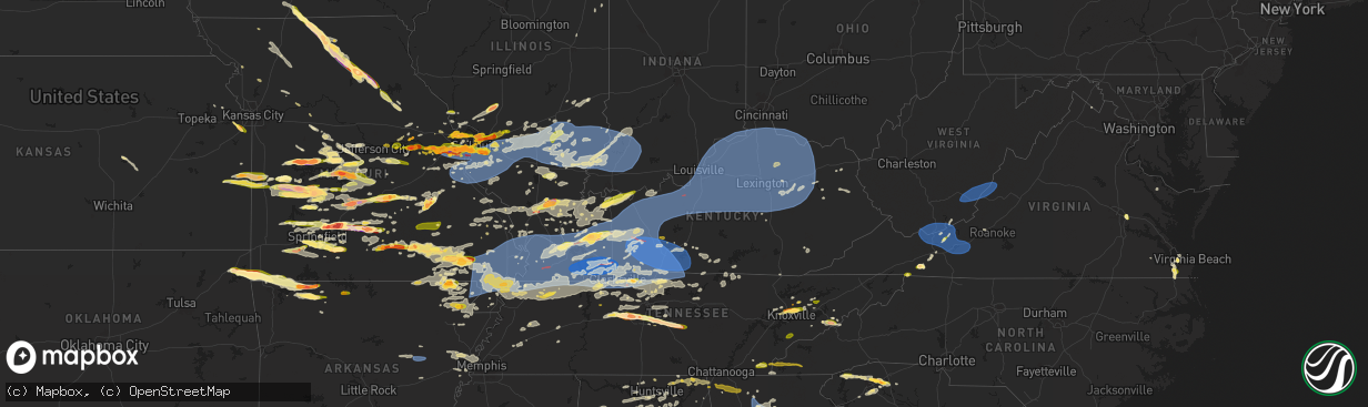
Hail
Wind
Tornado
15,368
Estimated number of impacted properties by a 1.00" hail or larger1,404
Estimated number of impacted properties by a 1.75" hail or larger619
Estimated number of impacted properties by a 2.50" hail or largerStorm reports in Kentucky
Kentucky
| Date | Description |
|---|---|
| 05/26/20246:12 PM CDT | 2 large trees down on stone creek drive. Report via social media. |
| 05/26/20242:55 PM CDT | Roof blown off with trees down. |
| 05/26/20242:54 PM CDT | A tree was down on mudlick of hardy that brought down powerlines. This is a public report via social media. The event time is radar estimated. |
| 05/26/20242:51 PM CDT | Trees were reported to have been downed in the belfry area. The event time is radar estimated. |
| 05/26/20242:51 PM CDT | Trees down on beauty road. The event time is radar estimated. |
| 05/26/20242:50 PM CDT | A tree was down blocking the road in upper pond creek at ballfork mountain. This is a public report via social media. The event time is radar estimated. |
| 05/26/20242:47 PM CDT | Tree down blocking one lane. |
| 05/26/20242:41 PM CDT | A tree was down near 1000 tomahawk road tomahawk... Ky. The event time is radar estimated. |
| 05/26/20242:37 PM CDT | A tree was down on ky 80 between solid waste department and ferrells creek road. This is a public report via social media. The event time is radar estimated. |
| 05/26/20242:34 PM CDT | A tree was down onto us 460/ky 80 near the old millard high school. This is a public report via social media. The event time is radar estimated. |
| 05/26/20242:33 PM CDT | Corrects previous tstm wnd dmg report from ashcamp. Trees were reported to have been blown down. The event time is radar estimated. |
| 05/26/20242:33 PM CDT | Trees and powerlines down on ashcamp mountain/ky 195 near ashcamp. This is a public report via social media. The event time is radar estimated. |
| 05/26/20242:32 PM CDT | A tree was reported to have been blown down on town mountain road on social media. The event time is radar estimated. |
| 05/26/20242:32 PM CDT | A tree was blown down near boons camp. The event time is radar estimated. |
| 05/26/20242:29 PM CDT | Trees were reported to have been blown down. The event time is radar estimated. |
| 05/26/20242:28 PM CDT | Trees were down near the intersection of island creek road/ky 1426 hoopwood branch. This is a public report via social media. The event time is radar estimated. |
| 05/26/20242:28 PM CDT | Multiple trees were reported to have been blown down on collins street including one onto a utility line. Trees were also down on collins hwy nearby. |
| 05/26/20242:27 PM CDT | Trees and utility lines were blown down on oklahoma hollow near allen. The event time is radar estimated. |
| 05/26/20242:26 PM CDT | Trees were reported to have been blown down on ky 1426 in the toler creek community. The event time is radar estimated. |
| 05/26/20242:26 PM CDT | A tree was blown down onto ky 1426 in the prater creek community. |
| 05/26/20242:23 PM CDT | Trees were reported to have been blown down in martin. The event time is radar estimated. |
| 05/26/20242:22 PM CDT | Trees were reported to have been blown down in virgie. The event time is radar estimated. |
| 05/26/20242:20 PM CDT | Tree down at caroline rd. And greenup ave. In raceland blocking one lane. Time estimated from radar. |
| 05/26/20242:17 PM CDT | Trees were reported down near ky 404 and ky 1210 intersection. The event time is radar estimated. |
| 05/26/20242:13 PM CDT | Trees were reported to have been blown down in hueysville. The event time is radar estimated. |
| 05/26/20242:06 PM CDT | Trees were reported to have been downed on ky 550 in the jones fork community. The event time is radar estimated. |
| 05/26/20242:05 PM CDT | A tree was blown down along route 7/southeast licking river road south of salyersville. The event time is radar estimated. |
| 05/26/20242:05 PM CDT | Corrects previous tstm wnd dmg report from raceland. Roof blown off with trees down. |
| 05/26/20242:05 PM CDT | Tree down in area of red devil ln and seaton dr intersection in russel. |
| 05/26/20242:04 PM CDT | Trees were reported to have been blown down along mine fork road. The event time is radar estimated. |
| 05/26/20242:03 PM CDT | Numerous reports of trees and power lines down throughout the county. |
| 05/26/20241:59 PM CDT | Trees were blown down along old lick creek road. The event time is radar estimated. |
| 05/26/20241:58 PM CDT | A tree was blown down in the city of salyersville. The event time is radar estimated. |
| 05/26/20241:53 PM CDT | Trees were reported down on ky 550 near montgomery creek. The event time is radar estimated. |
| 05/26/20241:50 PM CDT | Trees down on ky 550 near the perry county line. The event time is radar estimated. |
| 05/26/20241:50 PM CDT | Trees were reported down near 2700 pigeon roost road near pilgrim. The event time is radar estimated. |
| 05/26/20241:49 PM CDT | A tree was reported to have been blown down at the morgan/magoffin county line along us 460. The event time is radar estimated. |
| 05/26/20241:49 PM CDT | Trees reportedly blown down onto mobile homes... Power lines and roads in the avawam area. Time estimated from radar. |
| 05/26/20241:49 PM CDT | Report of multiple trees down on ky 160 near gordon not far from kingdom come state park. The event time is radar estimated. |
| 05/26/20241:48 PM CDT | Trees were reported to have been blown down. The event time is radar estimated. |
| 05/26/20241:45 PM CDT | Trees were reported to have been blown down at the wendell h ford airport. The event time is radar estimated. |
| 05/26/20241:44 PM CDT | Trees were reported to have been blown down. The event time is radar estimated. |
| 05/26/20241:42 PM CDT | Trees were reported to have been blown down. The event time is radar estimated. |
| 05/26/20241:41 PM CDT | Numerous reports of trees and power lines down throughout the county... Including within the city limits of hazard. Time estimated via radar. |
| 05/26/20241:40 PM CDT | Large limbs reported down via mping. The event time is radar estimated. |
| 05/26/20241:38 PM CDT | Trees and power lines down at residence on james court. Time estimated via radar. |
| 05/26/20241:34 PM CDT | A tree was blown down on ky 191 near adele and helechawa. The event time is radar estimated. |
| 05/26/20241:31 PM CDT | Social media report of trees down in buckhorn. One downed tree demolished a swing set and trampoline. Time estimated by radar. |
| 05/26/20241:31 PM CDT | Several trees and powerlines were blown down and one fell on a mobile home severely damaging it. The event time is estimated from radar. |
| 05/26/20241:29 PM CDT | A tree was blown down near 3000 liberty road. The event time is radar estimated. |
| 05/26/20241:27 PM CDT | Trees were blown down on ky 7 near wrigley. The event time is radar estimated. |
| 05/26/20241:16 PM CDT | Tree blown down on ky-1534 about 1/4 mile off of us-119. |
| 05/26/20241:14 PM CDT | Many trees blown down around the city of middlesboro. |
| 05/26/20241:14 PM CDT | Social media report of trees down on power lines in the page community off us hwy 119. Lines also down near train trestle. Time estimated by radar. |
| 05/26/20241:14 PM CDT | Social media report of tree down blocking the highway across ky 66 at mm 8. |
| 05/26/20241:14 PM CDT | Tree snapped at its base at a residence in kettle island. Power lines appear down in photo via social media. Time estimated by radar. |
| 05/26/20241:13 PM CDT | Social media report with drone photos of large trees down on the east side of middlesboro. Time estimated by radar. |
| 05/26/20241:12 PM CDT | Tree blown down at cow fork and ky-2011 intersection. Time estimated from radar. |
| 05/26/20241:12 PM CDT | Two trees blown down on mud lick rd. Time estimated from radar. |
| 05/26/20241:11 PM CDT | Tree down on power lines on edgewood road in middlesboro. Report with photo via social media. Time estimated by radar. |
| 05/26/20241:11 PM CDT | Large tree down on house at virginia ave in middlesboro. Report with photo via social media. Tine estimated by radar. |
| 05/26/20241:11 PM CDT | 1 small tree and 1/2 of another tree blown down in vicinity of memory lane. |
| 05/26/20241:10 PM CDT | Corrects previous tstm wnd dmg report from noetown. 2 large trees down on stone creek drive. Report via social media. Time estimated via radar. |
| 05/26/20241:10 PM CDT | Large tree down on camper vehicle. Report with photo via social media. Time estimated by radar. |
| 05/26/20241:10 PM CDT | Social media report with photos of trees and power lines down on upper gibson lane. Time estimated by radar. |
| 05/26/20241:10 PM CDT | Social media report with photos of trees snapped and uprooted on blakely lane in middlesboro. Time estimated via radar. |
| 05/26/20241:10 PM CDT | Social media report with photos of tree damage and power lines down. |
| 05/26/20241:10 PM CDT | Social media report with photo of large tree snapped at base on new wilson lane. |
| 05/26/20241:10 PM CDT | Social media report with photo of large tree down at east end trailer park near lower gibson lane in middlesboro. Time estimated by radar. |
| 05/26/20241:10 PM CDT | Tree down with electric pole leaning at middlesboro fire station #2. Report via social media. Time estimated by radar. |
| 05/26/20241:08 PM CDT | Numerous reports of trees down across roads throughout the county. A few phone lines also down throughout the county. Time estimated by radar. |
| 05/26/20241:08 PM CDT | *** 1 inj *** tree down on picnic shelter at rawlings stintson park. 1 person sustained non-life threatening injury and transported by ambulance. Time estimated via rad |
| 05/26/20241:08 PM CDT | Trees down on apartment building at beech creek apartments. Building had to be evacuated. |
| 05/26/20241:08 PM CDT | Photo of a tree leaning on house. Report with photos via social media. Time estimated by radar. |
| 05/26/20241:07 PM CDT | Large tree snapped on oak drive in pineville. Report with photo via social media. Time estimated via radar. |
| 05/26/20241:06 PM CDT | Tree and electric lines down on house on lucy lane off ky hwy 80. House caught on fire. |
| 05/26/20241:05 PM CDT | Trees reported down countywide. |
| 05/26/20241:02 PM CDT | Power lines down on unoccupied vehicle. Time estimated by radar. |
| 05/26/20241:02 PM CDT | Reports of trees and power lines down throughout the county. Time estimated by radar. |
| 05/26/20241:01 PM CDT | Corrects previous non-tstm wnd gst report from somerset pulaski county. Mesonet station somk2 somerset raws. |
| 05/26/20241:00 PM CDT | Multiple trees blown down including over power lines in the vicinity of bridge hollow... Slate branch spur and slate branch roads. |
| 05/26/20241:00 PM CDT | Tree down in roadway. Time estimated via radar. |
| 05/26/20241:00 PM CDT | Multiple trees blown down including over power lines in the vicinity of bridge hollow... Slate branch spur and sla |
| 05/26/202412:59 PM CDT | Trees uprooted and power lines down in fonde area. Location estimated. Report via social media with photo. Time estimated by radar. |
| 05/26/202412:51 PM CDT | Laurel county em reports damage to at least one building at flea land flea market in london. Photos show roof missing of one building. Radar showed possible brief rotat |
| 05/26/202412:51 PM CDT | Corrects previous non-tstm wnd gst report from 1 ese london-corbin airport. Asos station kloz london-corbin apt. |
| 05/26/202412:50 PM CDT | 2 foot diameter tree on power line and shingles blown off of a roof in fonde. |
| 05/26/202412:49 PM CDT | Corrects previous tstm wnd dmg report from 1 nw siler. Pictures appear to show damage at speedy mart gas station at intersection of ky-3041 and us-25 e. Time estimated |
| 05/26/202412:49 PM CDT | Large tree blown down onto trampoline and fence enclosure near levi jackson park. Time estimated from radar. |
| 05/26/202412:47 PM CDT | Tree down in roadway on convict pike. Time estimated via radar. |
| 05/26/202412:46 PM CDT | Trained spotter reported possible swath of damage between legacy chevrolet and lynn camp middle/high school. Time estimated from radar. Possible tornado. |
| 05/26/202412:43 PM CDT | Social media report with photos of trees down near lynn camp school school near us 25e and ky 830 in the corbin/gray area. Time estimated by radar. |
| 05/26/202412:42 PM CDT | Social media report of a half-dozen or more trees down along old doe creek road and barnes mountain road. Time estimated by radar. |
| 05/26/202412:42 PM CDT | Social media report of trees down blocking ky highway 213 at the brick plant. |
| 05/26/202412:41 PM CDT | Trees were ported in mount sterling and throughout montgomery county. The event time is radar estimated. |
| 05/26/202412:39 PM CDT | Large limbs were reported down via mping. The event time is radar estimated. |
| 05/26/202412:36 PM CDT | Tree down on power line. Time estimated via radar. |
| 05/26/202412:36 PM CDT | Power line down at residence on armour street. |
| 05/26/202412:35 PM CDT | Trees and power lines down across train tracks along us highway 421. Time estimated via radar. |
| 05/26/202412:34 PM CDT | Tree down on power line. Time estimated via radar. |
| 05/26/202412:32 PM CDT | Tree down on power line at a residence on pea ridge road. |
| 05/26/202412:32 PM CDT | Trees and power lines down. Time estimated via radar. |
| 05/26/202412:30 PM CDT | Numerous trees reported down throughout the county. |
| 05/26/202412:30 PM CDT | Tree down blocking ky hwy 2005. Time estimated via radar. |
| 05/26/202412:30 PM CDT | Multiple trees were blown down onto ky-192 leaving the highway impassable in the mount victory fd and bee rock areas. Time estimated from radar. |
| 05/26/202412:28 PM CDT | Tree down on rose ridge rd. |
| 05/26/202412:26 PM CDT | Tree blown down across lemon northcutt road. |
| 05/26/202412:26 PM CDT | Tree down on cars at the winchester country club. |
| 05/26/202412:25 PM CDT | Picture of trees... Limbs and powerlines down in carlisle from twitter. |
| 05/26/202412:25 PM CDT | Large tree limbs down on south end of georgetown. |
| 05/26/202412:25 PM CDT | Tree blown down blocking knoxville road. |
| 05/26/202412:25 PM CDT | Pictures of trees down in the city of cynthiana on twitter. |
| 05/26/202412:23 PM CDT | Tree blown down across lebanon road. |
| 05/26/202412:22 PM CDT | Scattered reports of trees down and power outages throughout the county. Time estimated via radar. |
| 05/26/202412:20 PM CDT | Large limbs were reported to have been blown down via mping. The event time is radar estimated. |
| 05/26/202412:17 PM CDT | Numerous reports and photos via social media of trees down and property damage in and around somerset. Time estimated by radar. |
| 05/26/202412:13 PM CDT | Trees and powerlines down. Additional tree damage countywide. |
| 05/26/202412:10 PM CDT | Reports of trees and power lines down throughout the county... Including a few trees blocking roadways. |
| 05/26/202412:10 PM CDT | Trees down in roadway on ky hwy 1013 near the sawmill. Time estimated via radar. |
| 05/26/202412:09 PM CDT | Shed displaced and trailer home roof damaged by thunderstorm winds. Time estimated from radar. |
| 05/26/202412:07 PM CDT | Tree and power lines down at residence on farris branch rd. Time estimated via radar. |
| 05/26/202412:05 PM CDT | East main street at chambers avenue closed due to a tree down on the roadway and over power lines. |
| 05/26/202412:03 PM CDT | Corrects previous tstm wnd dmg report from 2 wnw pewee valley. Large tree down on orchard grass blvd. |
| 05/26/202412:03 PM CDT | Trees down on black rock road. Time estimated from radar. |
| 05/26/202412:03 PM CDT | Trees down on 465 near sparta. Time estimated from radar. |
| 05/26/202412:02 PM CDT | Tree across hammond schoolhouse road. Time estimated from radar. |
| 05/26/202412:01 PM CDT | Three trees down on new liberty turnpike. |
| 05/26/202412:00 PM CDT | Damaged barns... Galvanized steel roof panels removed and chimney destroyed. Silo partially destroyed. |
| 05/26/202411:58 AM CDT | Tree down on old sweet owen road. Time estimated from radar. |
| 05/26/202411:53 AM CDT | Numerous trees down. |
| 05/26/202411:50 AM CDT | Trees down in yard near salvisa. |
| 05/26/202411:50 AM CDT | Pictures of a roof peeled off a barn in victoria estates subdivision. |
| 05/26/202411:48 AM CDT | A local report indicates 60 MPH wind near 3 E Danville |
| 05/26/202411:47 AM CDT | Tree down on george creek road. Time estimated from radar. |
| 05/26/202411:45 AM CDT | Trees down on skyview dr near frankfort. |
| 05/26/202411:40 AM CDT | Motorist stuck in vehicle on aaron barnett rd. Pinned in by fallen trees and cannot drive either direction. |
| 05/26/202411:39 AM CDT | Large tree limbs down in yard near tyrone. |
| 05/26/202411:38 AM CDT | Large branches blown out of mature oak trees. Tree down and power lines down woodford street... Lawrenceburg. |
| 05/26/202411:38 AM CDT | Power lines down in the city of russell springs. |
| 05/26/202411:35 AM CDT | Trees down on west harper ln. Tree on mobile home. |
| 05/26/202411:30 AM CDT | Several trees uprooted. |
| 05/26/202411:29 AM CDT | Trees down in pendleton. |
| 05/26/202411:25 AM CDT | Multiple trees down in a yard off route 60 and scott station road. |
| 05/26/202411:25 AM CDT | Tree down in 3100 block of rock creek drive. Many large branches down throughout seneca park. |
| 05/26/202411:25 AM CDT | Large trees down at narwood and gateway dr. |
| 05/26/202411:20 AM CDT | Building damaged... Camper overturned and dozens of trees down. |
| 05/26/202411:19 AM CDT | Corrects previous tstm wnd dmg report from 2 wnw pewee valley. Large tree down on orchard grass blvd. |
| 05/26/202411:16 AM CDT | Large tree limbs and several trees down in douglass hills park. |
| 05/26/202411:16 AM CDT | Trees down and power lines down on shelbyville road in eastwood. |
| 05/26/202411:16 AM CDT | 10 power lines down and several large oak tree limbs down at the intersection of cambridge road and pennyroyal road. |
| 05/26/202411:15 AM CDT | Trees down. |
| 05/26/202411:15 AM CDT | Trees down. Large tree on house at the intersection of taylorsville rd and six mile. |
| 05/26/202411:15 AM CDT | Numerous trees down between breckenridge ln and cannons ln. There are also trees down in seneca park. |
| 05/26/202411:15 AM CDT | Two trees down over dorsey lane. |
| 05/26/202411:15 AM CDT | Trees and powerlines down across the city of campbellsville. |
| 05/26/202411:14 AM CDT | Large tree limbs down in yard. |
| 05/26/202411:14 AM CDT | Significant damage to home on saloma road. |
| 05/26/202411:14 AM CDT | Large trees uprooted in a yard. |
| 05/26/202411:09 AM CDT | A local report indicates 65 MPH wind near Mount Washington |
| 05/26/202411:06 AM CDT | A local report indicates 63 MPH wind near Louisville Int'l Airpor |
| 05/26/202411:06 AM CDT | Reports of trees down. |
| 05/26/202411:00 AM CDT | Trees down in the city and all over the county. |
| 05/26/202410:55 AM CDT | Trees and power lines down in valley station from pictures sent in on twitter. |
| 05/26/202410:50 AM CDT | Many branches and tree limbs down. A few trees down along hedge rows. |
| 05/26/202410:50 AM CDT | Multiple trees down at the installation. |
| 05/26/202410:48 AM CDT | Trees down. |
| 05/26/202410:40 AM CDT | Lots of trees down. |
| 05/26/202410:38 AM CDT | Multiple trees on roads and homes and power lines down in eastern meade county. |
| 05/26/202410:35 AM CDT | Barn collapsed in garrett. |
| 05/26/202410:35 AM CDT | Roof peeled off out building by high winds. |
| 05/26/202410:35 AM CDT | Couple of trees down across the farm. Time based on radar. |
| 05/26/202410:20 AM CDT | A local report indicates 60 MPH wind near 2 WSW Holland |
| 05/26/202410:15 AM CDT | Breckinridge county mesonet measured 58 mph gust. |
| 05/26/202410:15 AM CDT | At least a 200yd swath which several downed trees/large broken limbs... Camper blown over... Garage destroyed with outer walls left but damaged. Debris seemingly all st |
| 05/26/202410:15 AM CDT | Corrects time on the previous tstm wnd dmg report from 4 nw leitchfield. Building damaged... Camper overturned and dozens of trees down. |
| 05/26/20249:55 AM CDT | Uprooted tree in yard on new cut road. |
| 05/26/20249:55 AM CDT | Trees down at the intersection of w cedar and john j johnson. |
| 05/26/20249:55 AM CDT | Trees down intersection of 31w and industrial dr. |
| 05/26/20249:55 AM CDT | Mesonet station gfsk2 greenville ky. |
| 05/26/20249:49 AM CDT | Extensive damage to houses in the communities of beechmont and drakesboro with searches ongoing. Many roads blocked. Time estimated by radar. |
| 05/26/20249:45 AM CDT | Video sent in on twitter of large tree falling on a house. |
| 05/26/20249:40 AM CDT | Lots of trees down in the 8000 block of rochester rd. |
| 05/26/20249:40 AM CDT | Large trees and power lines down on 9th street downtown. |
| 05/26/20249:40 AM CDT | A nws storm survey team found straight-line wind damage consistent with 70-75 mph winds in russellville... Ky. Part of the roofing structure of the russellville fire de |
| 05/26/20249:32 AM CDT | Trees blown down a few on houses. |
| 05/26/20249:25 AM CDT | Trees down and structural damage. |
| 05/26/20249:21 AM CDT | Corrects previous tornado report from 1 n bremen. Ef-1 tornado... 90 mph damage along a 9.8-mile track. |
| 05/26/20249:03 AM CDT | Power lines leaning and metal across the road. |
| 05/26/20249:00 AM CDT | Trees down over much trigg county. |
| 05/26/20248:59 AM CDT | Ef-2 tornado started at 8:59 a.m. Near highway 525 southeast of cadiz... And continued 19 miles... To about 7 miles southeast of hopkinsville or just northwest of pembr |
| 05/26/20248:56 AM CDT | Lots of trees down... Many on roads such as oliver rd and n. Montgomery rd. |
| 05/26/20248:55 AM CDT | Cadiz county hospital has no power and no generator. Multiple trees on lines near hospital. |
| 05/26/20248:50 AM CDT | Ef-1 tornado traveled for 6 miles in rural southern trigg county just south of highway 807 and ended along highway 139 south of cadiz. Wind damage was also observed nor |
| 05/26/20248:50 AM CDT | Tree blown over on house causing structural damage. |
| 05/26/20248:48 AM CDT | Trees down in princeton. |
| 05/26/20248:35 AM CDT | A local report indicates 64 MPH wind near 3 ESE Kirksey |
| 05/26/20248:35 AM CDT | Estimated 70 mph winds. Trees down on the southwest side of murray. |
| 05/26/20248:33 AM CDT | A local report indicates 70 MPH wind near Benton |
| 05/26/20248:32 AM CDT | Multiple trees down. |
| 05/26/20248:22 AM CDT | Mmultiple 4-6 in limbs and 2 large mature tree down. One uprooted tree. |
| 05/26/20248:20 AM CDT | People trapped in home. Possible tornado. |
| 05/26/20248:19 AM CDT | Multiple trees down in the milburn and beulah areas. |
| 05/26/20248:15 AM CDT | Trees blown down and blocking the road at clarkline and old mayfield roads. |
| 05/26/20248:10 AM CDT | Ef-1 tornado. Winds 100 mph. 5 mile track. |
| 05/26/20248:10 AM CDT | Trees down north and east sides of hickman county. |
| 05/26/20248:08 AM CDT | Tree blown down on house in western mccracken county. |
| 05/26/20248:03 AM CDT | Trees down and flooding. |
| 05/26/20247:55 AM CDT | Multiple trees down. Many across sr 80 between arlington and milburn. |
| 05/26/20247:30 AM CDT | Trees uprooted... Metal roof of barn peeled back. |
| 05/26/20242:12 AM CDT | Trees were reported to have been blown down on olive street via social media. The event time is radar estimated. |
| 05/26/20241:17 AM CDT | A tree was reported to have been blown down on ky 11 about 4 miles north of barbourville. The event time is radar estimated. |
| 05/26/20241:17 AM CDT | A tree was reported to have been blown down via social media. The event time is radar estimated. |
| 05/26/20241:04 AM CDT | A tree was reported to have been blown down tree down near quillen chapel exit 42 of the mountain parkway. The event time is radar estimated. |
| 05/26/20241:03 AM CDT | A tree fell onto a residence on camelot place in the city of london. The event time is radar estimated. |
| 05/26/202412:58 AM CDT | A large tree was blown down onto level green road. Near keavy. The event time is radar estimated. |
| 05/26/202412:55 AM CDT | A large tree was blown down in front of 266 waterworks road. The event time is radar estimated. |
| 05/26/202412:43 AM CDT | Trees were reported to have been blown down at 77 river drive between irvine and ravenna. The event time is radar estimated. |
| 05/26/202412:40 AM CDT | Multiple trees down. 1030 college hill rd... Waco... Ky. |
| 05/26/202412:35 AM CDT | Numerous 911 calls reporting roof collapse at conley bottom resort main pier on lake cumberland with people trapped on the boats. |
| 05/26/202412:18 AM CDT | Large limbs reported to have been blown down. Public report via mping. |
| 05/25/202411:51 PM CDT | Several trees down in fairplay community. |
| 05/25/202411:51 PM CDT | Several trees down in downtown burkesville. |
| 05/25/202411:50 PM CDT | Damage to boat storage units on northridge rd. |
| 05/25/202411:48 PM CDT | *** 1 inj *** tree down on a house in hardin heights. One person injured. |
| 05/25/202411:48 PM CDT | *** 1 fatal *** corrects previous tstm wnd dmg report from 3 s high bridge. Tree fell on a house in hardin heights. One person was killed. |
| 05/25/202411:36 PM CDT | *** 1 fatal *** nws survey team determined a path of straight-line wind damage beginning in harrodsburg... Kentucky through northern garrard county. Maximum winds were |
| 05/25/202411:31 PM CDT | Tree down on bluff road. |
| 05/25/202411:27 PM CDT | Two trees down on a home on legion park road. |
| 05/25/202411:25 PM CDT | Tree down over bluff bloom road. |
| 05/25/202411:24 PM CDT | Several trees down in greensburg. |
| 05/25/202411:19 PM CDT | Tree down over highway 218 near bishop road. |
| 05/25/202411:18 PM CDT | Sporadic tree and power line damage in marion county... Including one tree down over a road in lebanon. |
| 05/25/202411:09 PM CDT | Roof blown off manufactured home and multiple trees down. |
| 05/25/202410:59 PM CDT | Structural damage to a building in downtown horse cave. |
| 05/25/202410:55 PM CDT | Roof blown off carport and powerlines down near hwy 31w. |
| 05/25/202410:45 PM CDT | Several trees down on widener circle. |
| 05/25/202410:39 PM CDT | Kentucky mesonet station ewpk. |
| 05/25/202410:37 PM CDT | Nws storm survey team determined an ef1 tornado with 110mph winds impacted butler and warren counties on may 26... 2024. The tornado was 40 miles in total length with 3 |
| 05/25/202410:33 PM CDT | Significant second story damage to a home. |
| 05/25/202410:30 PM CDT | Trees down in hillview near christman lane. |
| 05/25/202410:18 PM CDT | Tree down in yard off bittersweet lane. |
| 05/25/202410:13 PM CDT | Structural damage to a home off knox avenue. |
| 05/25/202410:12 PM CDT | Tree down on power line. |
| 05/25/202410:12 PM CDT | Nws storm survey team determined an ef1 tornado with 90mph winds impacted eastern meade county on may 26... 2024. The tornado was 1.5 miles in length and 150 yards wide |
| 05/25/202410:12 PM CDT | Roof caved in on house at 3200 knox ave... Vine grove... Ky. |
| 05/25/202410:11 PM CDT | Nws storm survey team determined an ef1 tornado with 90mph winds impacted eastern meade county on may 26... 2024. The tornado was 1.5 miles in length and 150 yards wide |
| 05/25/202410:11 PM CDT | Downed tree and power lines on shot hunt road. |
| 05/25/202410:10 PM CDT | Multiple trees down. |
| 05/25/202410:10 PM CDT | Multiple trees down in lewisburg area. |
| 05/25/202410:00 PM CDT | Power lines down across river road. |
| 05/25/202410:00 PM CDT | Tree down over the road at old state rd and knollwood rd. |
| 05/25/20249:57 PM CDT | Nws storm survey team determined an ef1 tornado with 110mph winds impacted butler and warren counties on may 26... 2024. The tornado was 40 miles in total length with 3 |
| 05/25/20249:57 PM CDT | Tree down across hwy 79. |
| 05/25/20249:54 PM CDT | Power outages reported in irvington. |
| 05/25/20249:36 PM CDT | Tree down on easton cabot rd. |
| 05/25/20249:35 PM CDT | Power outages reported in cloverport. |
| 05/25/20249:27 PM CDT | Tree down on tick ridge rd. |
| 05/25/20249:19 PM CDT | Trees down. |
| 05/25/20249:15 PM CDT | Significant damage to several homes and trees in the vicinity of barnsley loop and u.s. 41. Possible tornado. |
| 05/25/20249:00 PM CDT | Numerous large trees down on the wk parkway/interstate 69 between central city and dawson springs. |
| 05/25/20248:52 PM CDT | Kyem reports damage to around 20 homes in the charleston community north of dawson springs. |
| 05/25/20248:24 PM CDT | *** 3 inj *** trees down across multiple roads making travel impossible. 3 minor injuries reported about 4-5 miles north of princeton. |
| 05/25/20248:16 PM CDT | Tennis to baseball size hail. |
| 05/25/20248:14 PM CDT | Tornado ongoing at this time. |
| 05/25/20248:00 PM CDT | A local report indicates 1.00 inch wind near 1 NE Robards |
| 05/25/20247:31 PM CDT | A local report indicates 1.00 inch wind near 1 NNW Calvert City |
| 05/25/20247:15 PM CDT | A local report indicates 1.00 inch wind near 1 E Ledbetter |
| 05/25/20247:01 PM CDT | *** 1 fatal... 21 inj *** ef-3 damage with peak winds at 160 mph. |
All States Impacted by Hail Map on May 26, 2024
Cities Impacted by Hail Map on May 26, 2024
- Pawnee City, NE
- Omaha, NE
- Crescent, IA
- Council Bluffs, IA
- Carter Lake, IA
- McClelland, IA
- Honey Creek, IA
- Underwood, IA
- Holcomb, MO
- Qulin, MO
- Knobel, AR
- Gideon, MO
- Corning, AR
- Pollard, AR
- Lafe, AR
- Delaplaine, AR
- Lilbourn, MO
- Rector, AR
- Malden, MO
- Gibson, MO
- Greenway, AR
- Paragould, AR
- Saint Francis, AR
- Parma, MO
- Bernie, MO
- Dexter, MO
- Campbell, MO
- Portageville, MO
- Catron, MO
- Piggott, AR
- Clarkton, MO
- Neelyville, MO
- Dudley, MO
- Poplar Bluff, MO
- Broseley, MO
- Fisk, MO
- Puxico, MO
- Bloomfield, MO
- San Saba, TX
- Richland Springs, TX
- Purmela, TX
- Evant, TX
- Gatesville, TX
- Thebes, IL
- Wardell, MO
- Essex, MO
- Kennett, MO
- Benton, MO
- Vanduser, MO
- Oran, MO
- Sikeston, MO
- New Madrid, MO
- Marston, MO
- Bell City, MO
- Canalou, MO
- Matthews, MO
- Goldthwaite, TX
- East Prairie, MO
- Charleston, MO
- Bragg City, MO
- Lometa, TX
- Crawford, TX
- Valley Mills, TX
- Woodway, TX
- China Spring, TX
- Hayti, MO
- Tiptonville, TN
- Jonesboro, TX
- Scott City, MO
- Olive Branch, IL
- Tamms, IL
- Miller City, IL
- Bertrand, MO
- Cairo, IL
- Union City, TN
- Hickman, KY
- Anniston, MO
- Ridgely, TN
- Hornbeak, TN
- Mounds, IL
- Troy, TN
- Pulaski, IL
- Mound City, IL
- La Center, KY
- Villa Ridge, IL
- Olmsted, IL
- Arlington, KY
- Clinton, KY
- Kevil, KY
- Grand Chain, IL
- Wickliffe, KY
- Barlow, KY
- Columbus, KY
- Bardwell, KY
- McGregor, TX
- Waco, TX
- Fulton, KY
- South Fulton, TN
- Rives, TN
- Fancy Farm, KY
- Wingo, KY
- Metropolis, IL
- Paducah, KY
- West Paducah, KY
- Cunningham, KY
- Melber, KY
- Hickory, KY
- Water Valley, KY
- Mayfield, KY
- Lampasas, TX
- Obion, TN
- Rantoul, IL
- Boaz, KY
- Brookport, IL
- Martin, TN
- Dukedom, TN
- Sedalia, KY
- Calvert City, KY
- Benton, KY
- Tiline, KY
- Palmersville, TN
- Smithland, KY
- Ledbetter, KY
- Burna, KY
- Golconda, IL
- Symsonia, KY
- Kenton, TN
- Sharon, TN
- Fort Hood, TX
- Summersville, MO
- Salem, KY
- Farmington, KY
- Grand Rivers, KY
- Marion, KY
- Kirksey, KY
- Gilbertsville, KY
- Fredonia, KY
- Kuttawa, KY
- Dexter, KY
- Eddyville, KY
- Hardin, KY
- Almo, KY
- Murray, KY
- Hazel, KY
- Puryear, TN
- Cottage Grove, TN
- Dresden, TN
- Princeton, KY
- New Concord, KY
- Buchanan, TN
- Cadiz, KY
- Olney, IL
- Noble, IL
- Moody, TX
- Greenfield, TN
- Providence, KY
- Big Rock, TN
- Dawson Springs, KY
- Dover, TN
- Bumpus Mills, TN
- Stewart, TN
- Gracey, KY
- Fort Campbell, KY
- La Fayette, KY
- Hopkinsville, KY
- Herndon, KY
- Cerulean, KY
- Nebo, KY
- Indian Mound, TN
- Paris, TN
- Temple, TX
- Killeen, TX
- Fremont, MO
- Gleason, TN
- Ellsinore, MO
- Oglesby, TX
- McKenzie, TN
- Henry, TN
- Saint Charles, KY
- Manitou, KY
- Hanson, KY
- Earlington, KY
- Madisonville, KY
- Nortonville, KY
- Crofton, KY
- Cumberland City, TN
- Woodlawn, TN
- Tennessee Ridge, TN
- Mortons Gap, KY
- Pembroke, KY
- Trenton, KY
- Elkton, KY
- Oak Grove, KY
- Clarksville, TN
- Palmyra, TN
- White Plains, KY
- Greenville, MO
- Copperas Cove, TX
- Mill Spring, MO
- Van Buren, MO
- Williamsville, MO
- Troy, TX
- Eddy, TX
- Bruceville, TX
- Lorena, TX
- Piedmont, MO
- Flat Rock, IL
- Kempner, TX
- Springville, TN
- Wappapello, MO
- Kankakee, IL
- Bonfield, IL
- Chilton, TX
- Grandin, MO
- Big Sandy, TN
- Adams, TN
- Cedar Hill, TN
- Cunningham, TN
- Southside, TN
- Ashland City, TN
- Chapmansboro, TN
- Springfield, TN
- Cumberland Furnace, TN
- Pleasant View, TN
- Guthrie, KY
- Olmstead, KY
- Powderly, KY
- Sharon Grove, KY
- Rumsey, KY
- Dunmor, KY
- Browder, KY
- Belton, KY
- Beechmont, KY
- Adairville, KY
- Russellville, KY
- Drakesboro, KY
- Graham, KY
- Centertown, KY
- Island, KY
- Greenville, KY
- Central City, KY
- Sacramento, KY
- Beech Creek, KY
- Allensville, KY
- Lewisburg, KY
- Bremen, KY
- Calhoun, KY
- Owensboro, KY
- Utica, KY
- Livermore, KY
- Philpot, KY
- Slaughters, KY
- Zalma, MO
- Marlin, TX
- Yorktown, AR
- Bourbonnais, IL
- McGee, MO
- Manteno, IL
- Cross Plains, TN
- Orlinda, TN
- Greenbrier, TN
- Morgantown, KY
- Franklin, KY
- Rochester, KY
- Woodburn, KY
- Beaver Dam, KY
- Cottontown, TN
- McHenry, KY
- Hartford, KY
- Rockport, KY
- Portland, TN
- Rockfield, KY
- White House, TN
- Auburn, KY
- Fordsville, KY
- Cromwell, KY
- Whitesville, KY
- Bowling Green, KY
- Olaton, KY
- Dundee, KY
- Rosine, KY
- Hawesville, KY
- Horse Branch, KY
- Reynolds Station, KY
- Caneyville, KY
- Falls Of Rough, KY
- Cloverport, KY
- Marble Hill, MO
- Advance, MO
- Grady, AR
- Milford, IL
- Thornton, TX
- Hardinsburg, KY
- Scottsville, KY
- Alvaton, KY
- Adolphus, KY
- Westmoreland, TN
- Bethpage, TN
- Watseka, IL
- Lott, TX
- Holland, KY
- Lafayette, TN
- De Witt, AR
- Rosebud, TX
- Gallatin, TN
- Reagan, TX
- Saint Charles, AR
- Ethel, AR
- Elaine, AR
- Holly Grove, AR
- Red Boiling Springs, TN
- Moss, TN
- Hartsville, TN
- Lake City, AR
- Harned, KY
- Guston, KY
- Webster, KY
- Irvington, KY
- McDaniels, KY
- Hudson, KY
- Garfield, KY
- Custer, KY
- Westview, KY
- Big Clifty, KY
- Rineyville, KY
- Cecilia, KY
- Clarkson, KY
- Vine Grove, KY
- Millwood, KY
- Eastview, KY
- Leitchfield, KY
- Elizabeth, IN
- Fort Knox, KY
- West Point, KY
- Charlestown, IN
- Ekron, KY
- Jeffersonville, IN
- Clarksville, IN
- New Albany, IN
- Muldraugh, KY
- Laconia, IN
- Shepherdsville, KY
- Sellersburg, IN
- Radcliff, KY
- Brandenburg, KY
- Louisville, KY
- Elizabethtown, KY
- Fisherville, KY
- Fairdale, KY
- Finchville, KY
- Glenview, KY
- Lebanon Junction, KY
- Taylorsville, KY
- Simpsonville, KY
- Coxs Creek, KY
- Prospect, KY
- Boston, KY
- Mount Washington, KY
- Masonic Home, KY
- Clermont, KY
- Brooks, KY
- Springfield, KY
- Bloomfield, KY
- Fairfield, KY
- Willisburg, KY
- Bardstown, KY
- Tompkinsville, KY
- Hestand, KY
- New Washington, IN
- Buckner, KY
- Goshen, KY
- Crestwood, KY
- Nabb, IN
- La Grange, KY
- Pewee Valley, KY
- Marysville, IN
- White Mills, KY
- Loretto, KY
- New Haven, KY
- Hodgenville, KY
- Sonora, KY
- Glendale, KY
- Westport, KY
- Shelbyville, KY
- Harrodsburg, KY
- Chaplin, KY
- Lawrenceburg, KY
- Smithfield, KY
- Mount Eden, KY
- Salvisa, KY
- Waddy, KY
- Sulphur, KY
- Bagdad, KY
- Bedford, KY
- Bethlehem, IN
- Pendleton, KY
- New Castle, KY
- Eminence, KY
- Milton, KY
- Hanover, IN
- Campbellsburg, KY
- Pleasureville, KY
- Frankfort, KY
- Byrdstown, TN
- Pall Mall, TN
- Livingston, TN
- Monroe, TN
- Lancaster, KY
- Wilmore, KY
- Burgin, KY
- Versailles, KY
- Mackville, KY
- Perryville, KY
- Danville, KY
- Stanford, KY
- Saint Catharine, KY
- Lebanon, KY
- Lockport, KY
- Vevay, IN
- Bethlehem, KY
- Sanders, KY
- Worthville, KY
- Madison, IN
- Owenton, KY
- Ghent, KY
- Carrollton, KY
- Perry Park, KY
- Turners Station, KY
- New Liberty, KY
- Midway, KY
- Nicholasville, KY
- Jamestown, TN
- Calvert, TX
- Bremond, TX
- Trimble, TN
- Paint Lick, KY
- Georgetown, KY
- Lexington, KY
- Stamping Ground, KY
- Richmond, KY
- Bennington, IN
- Warsaw, KY
- Franklin, TX
- Crab Orchard, KY
- Patriot, IN
- Union, KY
- Florence, IN
- Glencoe, KY
- Rising Sun, IN
- Verona, KY
- Corinth, KY
- Williamstown, KY
- Jonesville, KY
- Dry Ridge, KY
- Sadieville, KY
- Sparta, KY
- Waco, KY
- Berea, KY
- Cynthiana, KY
- Winchester, KY
- Paris, KY
- Keystone, SD
- Hermosa, SD
- Brodhead, KY
- Crittenden, KY
- Irvine, KY
- Falmouth, KY
- De Mossville, KY
- Berry, KY
- Walton, KY
- Morning View, KY
- Independence, KY
- Carlisle, KY
- Norfolk, VA
- Mount Vernon, KY
- Normangee, TX
- Millersburg, KY
- Mount Sterling, KY
- Alexandria, KY
- Clay City, KY
- North Middletown, KY
- Foster, KY
- Butler, KY
- Latonia, KY
- Brooksville, KY
- Mount Olivet, KY
- Melbourne, KY
- California, KY
- Owingsville, KY
- Jeffersonville, KY
- Ravenna, KY
- Slade, KY
- Stanton, KY
- Sharpsburg, KY
- New Richmond, OH
- Georgetown, OH
- Germantown, KY
- Tollesboro, KY
- Moscow, OH
- Olympia, KY
- Bethel, OH
- Manchester, OH
- Flemingsburg, KY
- Dover, KY
- Maysville, KY
- Salt Lick, KY
- Neville, OH
- Aberdeen, OH
- Hillsboro, KY
- Moorefield, KY
- Mayslick, KY
- Hope, KY
- Vanceburg, KY
- Frenchburg, KY
- Ewing, KY
- Means, KY
- Ripley, OH
- Felicity, OH
- Wallingford, KY
- Hamersville, OH
- Augusta, KY
- Morehead, KY
- West Union, OH
- Russellville, OH
- Amelia, OH
- Parksville, KY
- Wellington, KY
- Junction City, KY
- Saint Francis, KY
- Raywick, KY
- Pine Ridge, KY
- New Hope, KY
- Gravel Switch, KY
- Denniston, KY
- Madisonville, TX
- Erin, TN
- Camden, TN
- Eva, TN
- Waverly, TN
- Kosse, TX
- Clearfield, KY
- Chesapeake, VA
- Portsmouth, VA
- McEwen, TN
- Vanleer, TN
- Midway, TX
- Manchester, KY
- Fairburn, SD
- Goodlettsville, TN
- Joelton, TN
- Hendersonville, TN
- New Johnsonville, TN
- Nashville, TN
- Allen, SD
- Dickson, TN
- Rapid City, SD
- Charlotte, TN
- West Liberty, KY
- Whites Creek, TN
- White Bluff, TN
- Black Hawk, SD
- Cannel City, KY
- Olive Hill, KY
- Sandy Hook, KY
- Warsaw, VA
- Madison, TN
- Old Hickory, TN
- Mize, KY
- Farnham, VA
- Nunnelly, TN
- Pine Ridge, SD
- Grayson, KY
- Flatgap, KY
- Keaton, KY
- Bon Aqua, TN
- Castalian Springs, TN
- Burns, TN
- Scenic, SD
- Nemo, SD
- Lyles, TN
- Albany, KY
- Mount Juliet, TN
- Lebanon, TN
- Interior, SD
- Wanblee, SD
- Philip, SD
- Fairview, TN
- Franklin, TN
- Paintsville, KY
- Sitka, KY
- Stambaugh, KY
- Canton, NC
- Monticello, KY
- Pegram, TN
- Kingston Springs, TN
- Pleasant Shade, TN
- Carthage, TN
- Martin, SD
- Hill City, SD
- Dixon Springs, TN
- Primm Springs, TN
- Kincaid, KS
- Blue Mound, KS
- Mound City, KS
- Whitleyville, TN
- Gainesboro, TN
- Leicester, NC
- Candler, NC
- South Mills, NC
- Fort Yates, ND
- Montrose, MO
- Delaware, OK
- Pleasanton, KS
- Nolensville, TN
- Quinn, SD
- Clinton, MO
- Wall, SD
- Tipton, MO
- Knoxville, TN
- Brush Creek, TN
- Gordonsville, TN
- California, MO
- Clarksburg, MO
- Antioch, TN
- Tuthill, SD
- Hermitage, TN
- La Vergne, TN
- Quincy, MO
- Vinita, OK
- Warsaw, MO
- Centertown, MO
- Foster, MO
- Kyle, SD
- Mapleton, KS
- Prescott, KS
- Fulton, KS
- Weaverville, NC
- Barnardsville, NC
- Lansing, NC
- Whitetop, VA
- Bonnots Mill, MO
- Linn, MO
- Loose Creek, MO
- Arrington, TN
- Troutdale, VA
- Corryton, TN
- Powell, TN
- College Grove, TN
- Buffalo Valley, TN
- Granville, TN
- Chestnut Mound, TN
- Elmwood, TN
- Baxter, TN
- Damascus, VA
- Dunlap, IA
- Asheville, NC
- Alexander, NC
- Lockwood, MO
- Golden City, MO
- Heiskell, TN
- Clinton, TN
- Calhoun, MO
- Laurel Bloomery, TN
- Sugar Grove, VA
- Elk Creek, VA
- Lincoln, MO
- Burnsville, NC
- La Cygne, KS
- Windsor, MO
- Edwards, MO
- Porcupine, SD
- Jefferson City, MO
- Holts Summit, MO
- Hartsburg, MO
- Chamois, MO
- Butler, MO
- Rich Hill, MO
- Hume, MO
- Strafford, MO
- Fair Grove, MO
- Benton, TN
- Reliance, TN
- Smyrna, TN
- Murfreesboro, TN
- Fort Scott, KS
- Rockvale, TN
- Nowata, OK
- Virginia Beach, VA
- Luttrell, TN
- Blaine, TN
- Ocoee, TN
- Gravois Mills, MO
- Delano, TN
- Greenfield, MO
- Earling, IA
- Bloomington Springs, TN
- Pleasant Hope, MO
- Springfield, MO
- Morrison, MO
- Stover, MO
- Climax Springs, MO
- Zuni, VA
- Schell City, MO
- Walker, MO
- Harwood, MO
- New Bloomfield, MO
- Tebbetts, MO
- Rocky Mount, MO
- Eldon, MO
- Barnett, MO
- Hermann, MO
- Everton, MO
- Bridgeville, DE
- Rhineland, MO
- Afton, OK
- Marshall, NC
- Sandston, VA
- Walnut Grove, MO
- Rockville, MO
- Mouth Of Wilson, VA
- Collins, MO
- Weaubleau, MO
- Osceola, MO
- Readyville, TN
- Warrenton, MO
- Wright City, MO
- Marthasville, MO
- Atkins, VA
- Marion, VA
- Portland, MO
- Mokane, MO
- Steedman, MO
- Versailles, MO
- Wheatland, MO
- Appleton City, MO
- Marshfield, MO
- Elkland, MO
- Buffalo, MO
- Ash Grove, MO
- Fairland, OK
- Wyandotte, OK
- Grove, OK
- Berger, MO
- New Haven, MO
- Lake Ozark, MO
- Roach, MO
- Sunrise Beach, MO
- Camdenton, MO
- Osage Beach, MO
- Richards, MO
- Eugene, MO
- Henley, MO
- Lebanon, MO
- Long Lane, MO
- Farner, TN
- Turtletown, TN
- Foristell, MO
- Grassy Creek, NC
- Bland, VA
- El Dorado Springs, MO
- Strawberry Plains, TN
- Oak Ridge, TN
- Cole Camp, MO
- Crockett, VA
- Wytheville, VA
- Woodbury, TN
- Rutledge, TN
- Phillipsburg, MO
- Windyville, MO
- Bakersville, NC
- Green Mountain, NC
- Saint Thomas, MO
- Hermitage, MO
- Bradyville, TN
- Murphy, NC
- Mascot, TN
- Niangua, MO
- Flemington, MO
- Talbott, TN
- Jefferson City, TN
- Morristown, TN
- Washington, MO
- Dow, IL
- Lowry City, MO
- Crumpler, NC
- Florence, MO
- Tuscumbia, MO
- Anderson, MO
- South West City, MO
- Preston, MO
- Linn Creek, MO
- Pearisburg, VA
- Grovespring, MO
- Hartville, MO
- Brighton, MO
- Willard, MO
- Conway, MO
- Kaiser, MO
- Brumley, MO
- Oliver Springs, TN
- Narrows, VA
- Rogersville, MO
- New Market, TN
- Mansfield, MO
- Seymour, MO
- Maynardville, TN
- Cosby, TN
- Fortuna, MO
- Syracuse, MO
- Bluefield, VA
- Falls Mills, VA
- Pocahontas, VA
- Bramwell, WV
- Bluefield, WV
- Montcalm, WV
- Rock, WV
- Princeton, WV
- Kegley, WV
- Freeman, WV
- Bastian, VA
- Rocky Gap, VA
- Staffordsville, VA
- Ripplemead, VA
- Athens, WV
- Glen Lyn, VA
- Peterstown, WV
- Rich Creek, VA
- Pembroke, VA
- Eggleston, VA
- Radford, VA
- Pulaski, VA
- Belspring, VA
- Dublin, VA
- Parrott, VA
- Draper, VA
- Max Meadows, VA
- Morrisville, MO
- Pittsburg, MO
- Tallassee, TN
- Maryville, TN
- Freeburg, MO
- Richland, MO
- Batchtown, IL
- Hardin, IL
- Hartford, TN
- Montreal, MO
- O'Fallon, MO
- Saint Peters, MO
- Sevierville, TN
- Ulman, MO
- Noel, MO
- Lanagan, MO
- Dandridge, TN
- Richmond, VA
- Ballard, WV
- Jay, OK
- Augusta, MO
- Humansville, MO
- Waynesville, NC
- Westphalia, MO
- Saint Charles, MO
- Lake Saint Louis, MO
- Elsberry, MO
- Henrico, VA
- Pineville, MO
- Brighton, IL
- Godfrey, IL
- Jerseyville, IL
- Vonore, TN
- Saint Elizabeth, MO
- Clyde, NC
- Belle, MO
- Tiff City, MO
- Fieldon, IL
- Del Rio, TN
- Newport, TN
- Bolivar, MO
- Half Way, MO
- Urbana, MO
- Polk, MO
- Fair Play, MO
- Dunnegan, MO
- Mountain Grove, MO
- Waynesville, MO
- Laquey, MO
- Christiansburg, VA
- Iberia, MO
- Crocker, MO
- Meta, MO
- Wentzville, MO
- Shipman, IL
- Marble, NC
- Rock Port, MO
- Kadoka, SD
- Stockton, MO
- Macks Creek, MO
- Dixon, MO
- Foley, MO
- Stoutland, MO
- Mullen, NE
- Defiance, MO
- Vanzant, MO
- Koeltztown, MO
- Hot Springs, NC
- Riner, VA
- Indian Valley, VA
- Floyd, VA
- Hiwassee, VA
- Pilot, VA
- Willis, VA
- Owensville, MO
- Gerald, MO
- Union, MO
- Bridgeton, MO
- Earth City, MO
- Bella Vista, AR
- Seligman, MO
- Bentonville, AR
- Pea Ridge, AR
- Hazelwood, MO
- Garfield, AR
- Washburn, MO
- Powell, MO
- Graff, MO
- Labadie, MO
- Villa Ridge, MO
- Fort Leonard Wood, MO
- Saint Robert, MO
- Gray Summit, MO
- Louisburg, MO
- Florissant, MO
- Andrews, NC
- Hayesville, NC
- Franklin, NC
- Olean, MO
- Carlinville, IL
- Gillespie, IL
- Bland, MO
- Plato, MO
- Cabool, MO
- Huggins, MO
- Bucyrus, MO
- Pacific, MO
- Leslie, MO
- Willow Springs, MO
- Tunas, MO
- Saint Louis, MO
- Grafton, IL
- Elsah, IL
- Portage Des Sioux, MO
- Maryland Heights, MO
- Bunker Hill, IL
- Eagleville, TN
- Sunset, SC
- Salem, SC
- Cross Timbers, MO
- Saint Albans, MO
- Townsend, TN
- Walland, TN
- Wildwood, MO
- Devils Elbow, MO
- Houston, MO
- Chesterfield, MO
- Ballwin, MO
- Eureka Springs, AR
- Pickens, SC
- Litchfield, IL
- Salem, MO
- Eminence, MO
- Hartshorn, MO
- Rosebud, MO
- Duke, MO
- Newburg, MO
- Eureka, MO
- High Ridge, MO
- Rogers, AR
- Saint Ann, MO
- Elk Creek, MO
- Beaufort, MO
- Yukon, MO
- Eldridge, MO
- Salem, VA
- Vienna, MO
- Mountain View, MO
- Fenton, MO
- Valley Park, MO
- Granite City, IL
- Edwardsville, IL
- Collinsville, IL
- Maryville, IL
- Glen Carbon, IL
- Janesville, WI
- Troy, IL
- Hartwell, GA
- Dewy Rose, GA
- Bowman, GA
- Alton, IL
- Lynchburg, MO
- Norwood, MO
- Eagle Rock, MO
- Glenwood, IA
- Pacific Junction, IA
- Solo, MO
- Drury, MO
- Madison, IL
- Eunice, MO
- Gatlinburg, TN
- Milton, WI
- Whitewater, WI
- Fort Atkinson, WI
- Elberton, GA
- Berryville, AR
- Birch Tree, MO
- Saint Jacob, IL
- East Carondelet, IL
- Marine, IL
- Old Monroe, MO
- Winfield, MO
- Brussels, IL
- Falcon, MO
- Saint Clair, MO
- Sullivan, MO
- Jadwin, MO
- Rolla, MO
- Marietta, SC
- Easley, SC
- Travelers Rest, SC
- House Springs, MO
- Raymondville, MO
- East Alton, IL
- Hartford, IL
- Bunker, MO
- Venice, IL
- South Roxana, IL
- Roxana, IL
- Greenville, SC
- Highland, IL
- Edgar Springs, MO
- Arnold, MO
- Green Forest, AR
- East Saint Louis, IL
- Millstadt, IL
- Dupo, IL
- Ronceverte, WV
- Lewisburg, WV
- Asbury, WV
- White Sulphur Springs, WV
- Renick, WV
- Caldwell, WV
- Frankford, WV
- Maxwelton, WV
- Covington, VA
- Hot Springs, VA
- Alderson, WV
- Belleville, IL
- Saint James, MO
- Boss, MO
- Lonedell, MO
- Traphill, NC
- Imperial, MO
- Winona, MO
- Bixby, MO
- Grubville, MO
- Robertsville, MO
- Elkin, NC
- Viburnum, MO
- Alhambra, IL
- Catawissa, MO
- Steelville, MO
- Potosi, MO
- Fairview Heights, IL
- O'Fallon, IL
- Iva, SC
- Otto, NC
- Omaha, AR
- Lovejoy, IL
- Lebanon, IL
- Anderson, SC
- Pocahontas, IL
- Mars Hill, NC
- Sorento, IL
- Greenville, IL
- Caseyville, IL
- Ellington, MO
- Cook Sta, MO
- Davisville, MO
- Taylors, SC
- Hillsboro, MO
- Pevely, MO
- Cedar Hill, MO
- Dittmer, MO
- Barnhart, MO
- Columbia, IL
- Huntsville, AR
- Licking, MO
- Success, MO
- State Road, NC
- Pigeon Forge, TN
- Scott Air Force Base, IL
- Goreville, IL
- Alpena, AR
- Yellville, AR
- Walshville, IL
- Donnellson, IL
- West Alton, MO
- Belgrade, MO
- Wilsonville, IL
- Staunton, IL
- Marion, IL
- Carbondale, IL
- Waterloo, IL
- Valmeyer, IL
- New Athens, IL
- Pierce City, MO
- Cherryville, MO
- Greer, SC
- Redford, MO
- Mascoutah, IL
- Trenton, IL
- Creal Springs, IL
- Williamston, SC
- Roby, MO
- De Soto, MO
- Harrison, AR
- Griswold, IA
- Billings, MO
- Republic, MO
- Makanda, IL
- Fults, IL
- Piedmont, SC
- Pelzer, SC
- Freeburg, IL
- Smithton, IL
- Tampa, KS
- Marion, KS
- Aviston, IL
- Mount Carmel, IL
- Bartelso, IL
- Germantown, IL
- Beckemeyer, IL
- Albers, IL
- Carlyle, IL
- Breese, IL
- Festus, MO
- Merriman, NE
- Bellmont, IL
- Browns, IL
- Summerfield, IL
- Centerville, MO
- Blackwell, MO
- Bonne Terre, MO
- Albion, IL
- Verona, MO
- Monett, MO
- New Baden, IL
- Brookline, MO
- Nixa, MO
- Clever, MO
- Duncan, SC
- Woodruff, SC
- Moore, SC
- Carrier Mills, IL
- Stonefort, IL
- Harrisburg, IL
- Vandalia, IL
- Mulberry Grove, IL
- Ozark, MO
- Bois D Arc, MO
- Morganton, NC
- Marion, NC
- Keyesport, IL
- Sandoval, IL
- Centralia, IL
- Patoka, IL
- North Platte, NE
- Aurora, MO
- Simpsonville, SC
- Marionville, MO
- Allendale, IL
- Villisca, IA
- Nodaway, IA
- Addieville, IL
- Marissa, IL
- Decker, IN
- Smithboro, IL
- Grayville, IL
- Vincennes, IN
- Galatia, IL
- Eldorado, IL
- Corning, IA
- Salem, IL
- Kinmundy, IL
- Alma, IL
- Odin, IL
- Crane, MO
- Roebuck, SC
- Evansville, IL
- Walsh, IL
- Sparta, IL
- Ellis Grove, IL
- Sainte Genevieve, MO
- Brownstown, IL
- Annapolis, MO
- Fredericktown, MO
- Marquand, MO
- Vernon, IL
- Junction, IL
- Shawneetown, IL
- Shobonier, IL
- Fordland, MO
- Rural Retreat, VA
- Sparta, MO
- Fountain Inn, SC
- Bruner, MO
- Oldfield, MO
- Patton, MO
- Mount Vernon, IL
- Corydon, KY
- Herod, IL
- Equality, IL
- Woodlawn, IL
- Waltonville, IL
- Vulcan, MO
- Doniphan, MO
- Abbeville, SC
- Morganfield, KY
- Perryville, MO
- Sedgewickville, MO
- Iuka, IL
- Farina, IL
- Saint Peter, IL
- Afton, IA
- Maxwell, NE
- Nashville, IL
- Saint Mary, MO
- Louisville, IL
- Xenia, IL
- Glenallen, MO
- Tamaroa, IL
- Du Bois, IL
- Galena, MO
- Highlandville, MO
- Pomona, IL
- Macomb, MO
- Spartanburg, SC
- Pauline, SC
- Florence, KS
- Mason, IL
- Edgewood, IL
- Texico, IL
- Johnsonville, IL
- Kell, IL
- Walnut Hill, IL
- Bluford, IL
- Keenes, IL
- Dix, IL
- Hoffman, IL
- Hoyleton, IL
- Watson, IL
- Ingraham, IL
- Dieterich, IL
- Newton, IL
- Rinard, IL
- Clay City, IL
- Flora, IL
- Wheeler, IL
- Dundas, IL
- Sailor Springs, IL
- Grand Tower, IL
- New Florence, MO
- Jasper, AR
- Vendor, AR
- Neoga, IL
- Toledo, IL
- Greenup, IL
- Bonnie, IL
- Opdyke, IL
- Ava, MO
- Mulkeytown, IL
- Leopold, MO
- Belle Rive, IL
- Henderson, KY
- Robards, KY
- Du Quoin, IL
- Hidalgo, IL
- Scheller, IL
- Uniontown, MO
- Oak Ridge, MO
- Altenburg, MO
- Friedheim, MO
- Old Appleton, MO
- Frohna, MO
- Montgomery City, MO
- Ponce De Leon, MO
- Spokane, MO
- Sturgis, KY
- Jonesburg, MO
- Taylorsville, NC
- Moravian Falls, NC
- Lenoir, NC
- Granite Falls, NC
- Statesville, NC
- Hickory, NC
- Hiddenite, NC
- Conover, NC
- Claremont, NC
- Stony Point, NC
- Catawba, NC
- Reed, KY
- Spottsville, KY
- Casey, IL
- Washington, IN
- Connelly Springs, NC
- Valdese, NC
- Wheatland, IN
- Wayne City, IL
- Macedonia, IL
- Dahlgren, IL
- Ewing, IL
- Thompsonville, IL
- Benton, IL
- Sesser, IL
- Elkville, IL
- Royalton, IL
- Cisne, IL
- Geff, IL
- Sims, IL
- Fairfield, IL
- Clay, KY
- Millersville, MO
- Yale, IL
- Buckner, IL
- Saint Elmo, IL
- Altamont, IL
- Pittsburg, IL
- Uniontown, KY
- Ridgway, IL
- Alto Pass, IL
- Wolf Lake, IL
- Ina, IL
- Cape Girardeau, MO
- McLeansboro, IL
- Broughton, IL
- Martinsville, IL
- Ellston, IA
- Tingley, IA
- Grand River, IA
- Lamoni, IA
- Kellerton, IA
- Parkersburg, IL
- Calhoun, IL
- Jonesboro, IL
- McClure, IL
- Jackson, MO
- Sumner, IL
- Claremont, IL
- Elizabethtown, IL
- Cobden, IL
- Mount Vernon, IN
- Waverly, KY
- Golden Gate, IL
- Barnhill, IL
- Mount Erie, IL
- West Salem, IL
- Decatur, IA
- Leon, IA
- Elwood, NE
- Bertrand, NE
- Chaffee, MO
- Oaktown, IN
- Monroe City, IN
- Montgomery, IN
- Ellery, IL
- Bone Gap, IL
- West Liberty, IL
- Willow Hill, IL
- Oblong, IL
- Richland, IN
- Rockport, IN
- Bridgeport, IL
- Robinson, IL
- Hazleton, IN
- Princeton, IN
- Owensville, IN
- Bicknell, IN
- Francisco, IN
- Bruceville, IN
- Lawrenceville, IL
- Saint Francisville, IL
- Petersburg, IN
- Fort Branch, IN
- Patoka, IN
- Lynnville, IN
- Ragsdale, IN
- Spurgeon, IN
- Winslow, IN
- Haubstadt, IN
- Oakland City, IN
- Elberfeld, IN
- Norris City, IL
- Enfield, IL
- Elliott, IA
- Grant, IA
- Davis City, IA
- Ullin, IL
- Asheboro, NC
- Trinity, NC
- Sophia, NC
- Simpson, IL
- Dongola, IL
- Cypress, IL
- Lineville, IA
- Annapolis, IL
- Marshall, IL
- West York, IL
- West Union, IL
- Williams, IN
- Bedford, IN
- Harviell, MO
- Loogootee, IN
- Burfordville, MO
- Crane, IN
- Odon, IN
- Anna, IL
- Whitewater, MO
- Evansville, IN
- Eddyville, IL
- Cave In Rock, IL
- Ozark, IL
- Cynthiana, IN
- Griffin, IN
- Poseyville, IN
- Cainsville, MO
- Mercer, MO
- Diagonal, IA
- Mammoth Spring, AR
- Thayer, IA
- Fairdealing, MO
- Newburgh, IN
- Valley Springs, AR
- Maceo, KY
- Heltonville, IN
- Dixon, KY
- Sheridan, MO
- Princeton, MO
- Buncombe, IL
- Vienna, IL
- Norman, IN
- Oolitic, IN
- Avoca, IN
- Springville, IN
- Ravenden, AR
- Pocahontas, AR
- Couch, MO
- Myrtle, MO
- Ravenden Springs, AR
- Gatewood, MO
- Hampton, KY
- Rosiclare, IL
- Grantsburg, IL
- Sebree, KY
- Silva, MO
- Edwardsport, IN
- Lucerne, MO
- Newtown, MO
- Harris, MO
- Milan, MO
- Hildreth, NE
- Martinsburg, WV
- Mount Ayr, IA
- Gentry, MO
- Worth, MO
- Powersville, MO
- Plainville, IN
- Sandborn, IN
- Westphalia, IN
- Bloomington, NE
- Berryville, VA
- Lewisport, KY
- Warm Springs, AR
- Gipsy, MO
- Naylor, MO
- Lowndes, MO
- Elnora, IN
- Jasper, IN
- Otwell, IN
- Velpen, IN
- Cannelburg, IN
- Stendal, IN
- Holland, IN
- Huntingburg, IN
- Youngsville, NC
- New Boston, MO
- Cannelton, IN
- Rome, IN
- Kearneysville, WV
- Cassoday, KS
- Maynard, AR
- Summit Point, WV
- Pollock, MO
- Oxly, MO
- Shenandoah, IA
- Charles Town, WV
- Ranson, WV
- Tonganoxie, KS
- Linwood, KS
- Success, AR
- Searcy, AR
- Judsonia, AR
- McLouth, KS
- Franklinton, NC
- Green City, MO
- New Hampton, MO
- Green Castle, MO
- Oskaloosa, KS
- Albany, MO
- Mount Olive, IL
- Herculaneum, MO
- Seymour, IN
- Dorsey, IL
- Jonesville, IN
- Columbus, IN
- Elizabethtown, IN
- Mineral Point, MO
- Valles Mines, MO
- Cadet, MO
- French Village, MO
- McFall, MO
- Golden Eagle, IL
- Pomona, MO
- Biggers, AR
- Des Arc, MO
- Lesterville, MO
- Hecker, IL
- Lenzburg, IL
- Red Bud, IL
- Luebbering, MO
- Raymond, IL
- Bald Knob, AR
- Datto, AR
- Browning, MO
- Caledonia, MO
- Saint Libory, IL
- Pattonsburg, MO
- Bethany, MO
- New Douglas, IL
- New Burnside, IL
- Callao, MO
- Elmer, MO
- Sturdivant, MO
- Peach Orchard, AR
- High Hill, MO
- Ethel, MO
- Winigan, MO
- Bevier, MO
- Macon, MO
- Bonner Springs, KS
- Olathe, KS
- Lenexa, KS
- De Soto, KS
- Walnut Ridge, AR
- Shannon City, IA
- Cookville, TX
- Omaha, TX
- Jetson, KY
- Roundhill, KY
- Beech Grove, AR
- Cosby, MO
- Saint Joseph, MO
- Ramsey, IL
- Jameson, MO
- Overland Park, KS
- Stilwell, KS
- Gallatin, MO
- Brownsville, KY
- Clarence, MO
- Anabel, MO
- New Cambria, MO
- Oakland, KY
- Smiths Grove, KY
- Naples, TX
- Somerville, OH
- Park City, KY
- Easton, MO
- Madison, MO
- Bucklin, MO
- Atlanta, MO
- Wynne, AR
- Cherry Valley, AR
- Excello, MO
- Okolona, AR
- Rocky Hill, KY
- Marmaduke, AR
- Jamesport, MO
- Lock Springs, MO
- Stewartsville, MO
- Gower, MO
- Glasgow, KY
- Cardwell, MO
- Arbyrd, MO
- Jonesboro, AR
- Lucas, KY
- Etoile, KY
- Fountain Run, KY
- Austin, KY
- Bradford, AR
- Arkadelphia, AR
- Plattsburg, MO
- Holliday, MO
- Parkin, AR
- Gurdon, AR
- Jacksonville, MO
- Senath, MO
- Malvern, AR
- Cave City, KY
- Summer Shade, KY
- Eighty Eight, KY
- Paris, MO
- Burkesville, KY
- Beaumont, KY
- Edmonton, KY
- Leola, AR
- Earle, AR
- Hornersville, MO
- Sheridan, AR
- Lathrop, MO
- Turney, MO
- Newport, AR
- Cotton Plant, AR
- Steele, MO
- Sparkman, AR
- Richmond, MO
- Santa Fe, MO
- Crawfordsville, AR
- Leachville, AR
- Mexico, MO
- Monette, AR
- Allons, TN
- Augusta, AR
- McCrory, AR
- Doddridge, AR
- Grapevine, AR
- Turrell, AR
- Marion, AR
- Laddonia, MO
- Brinkley, AR
- Wheatley, AR
- Stanton, TN
- Widener, AR
- Heth, AR
- Leeton, MO
- Bells, TN
- Alamo, TN
- Polo, MO
- Rayville, MO
- Palestine, AR
- Bivins, TX
- Rodessa, LA
- Ida, LA
- Proctor, AR
- Humboldt, TN
- Gadsden, TN
- Cowgill, MO
- Rush Hill, MO
- Alpha, KY
- Norborne, MO
- Pine Bluff, AR
- Dover, MO
- Moro, AR
- Waverly, MO
- Concordia, MO
- Sweet Springs, MO
- Martinsburg, MO
- Rison, AR
- Brownsville, TN
- Marianna, AR
- Blackburn, MO
- Alma, MO
- Malta Bend, MO
- Olla, LA
- Cedar Grove, TN
- Jackson, TN
- Mercer, TN
- Denmark, TN
- Houstonia, MO
- Chidester, AR
- Town Creek, AL
- Athens, AL
- Rogersville, AL
- Courtland, AL
- Horn Lake, MS
- Walls, MS
- Medon, TN
- Kelly, LA
- Grayson, LA
- Camden, AR
- Hughesville, MO
- New Edinburg, AR
- Beech Bluff, TN
- Nelson, MO
- Byhalia, MS
- Olive Branch, MS
- Sedalia, MO
- Harrisonburg, LA
- Columbia, LA
- Enterprise, LA
- Winnsboro, LA
- Nesbit, MS
- Hernando, MS
- Williamsburg, KY
- Lexington, TN
- Thornton, AR
- Warren, AR
- Wilmar, AR
- Smithton, MO
- Bearden, AR
- Jellico, TN
- Lake Cormorant, MS
- Southaven, MS
- Monticello, AR
- Finger, TN
- Bethel Springs, TN
- Enville, TN
- Henderson, TN
- Fort Necessity, LA
- Wisner, LA
- Sicily Island, LA
- Toney, AL
- Pilot Grove, MO
- Otterville, MO
- Lascassas, TN
- Mora, MO
- Holly Springs, MS
- Huntsville, AL
- Winchester, AR
- Tillar, AR
- Huron, TN
- Luray, TN
- Red Banks, MS
- Harvest, AL
- New Market, AL
- Meridianville, AL
- Hazel Green, AL
- Lowmansville, KY
- River, KY
- Hampton, AR
- Clayton, LA
- Gilbert, LA
- Gurley, AL
- Princeton, AL
- Hollytree, AL
- Dermott, AR
- Aimwell, LA
- Lamar, MS
- Russellville, AL
- Tunica, MS
- Adamsville, TN
- Milledgeville, TN
- Sardis, TN
- Fordyce, AR
- Hamilton, AL
- Tremont, MS
- Vina, AL
- Hughes, AR
- Estillfork, AL
- Scottsboro, AL
- Saint Joseph, LA
- Spruce Pine, AL
- Latham, MO
- Hodges, AL
- Coldwater, MS
- Trinity, AL
- Hillsboro, AL
- Moulton, AL
- Russellville, MO
- Waterford, MS
- Decatur, AL
- Stevenson, AL
- Phil Campbell, AL
- Marston, NC
- Laurel Hill, NC
- Waterproof, LA
- Potts Camp, MS
- Belvidere, TN
- Lorman, MS
- Hackleburg, AL
- Huntland, TN
- Utica, MS
- Raymond, MS
- Fackler, AL
- Lake Village, AR
- Flora, MS
- Bridgeport, AL
- Sherwood, TN
- Hickory Flat, MS
- Tanner, AL
- Madison, AL
- Senatobia, MS
- Madison, MS
- Eudora, AR
- Portland, AR
- Bryant, AL
- Flat Rock, AL
- Myrtle, MS
- South Pittsburg, TN
- Canton, MS
- Danville, AL
- Greenville, MS
- Mount Hope, AL
- Terry, MS
- Parrottsville, TN
- Pisgah, AL
- Ider, AL
- Henagar, AL
- Etta, MS
- Como, MS
- Jasper, AL
- Crane Hill, AL
- Hollywood, AL
- Byram, MS
- Raeford, NC
- Hollandale, MS
- Brandon, MS
- New Albany, MS
- Blue Mountain, MS
- Morton, MS
- Pelahatchie, MS
- Maxton, NC
- Higdon, AL
- Trenton, GA
- Rising Fawn, GA
- Lena, MS
- Forest, MS
- Brownsboro, AL
- Owens Cross Roads, AL
- Chatham, MS
- Hartselle, AL
- Glen Allan, MS
- Bentonia, MS
- Arley, AL
- Bremen, AL
- Red Springs, NC
- Chickamauga, GA
- Blue Springs, MS
- Logan, AL
- Woodville, AL
- Decatur, MS
- Conehatta, MS
- Union, MS
- Jonesville, LA
- Braxton, MS
- Mendenhall, MS
- Guntown, MS
- Little Rock, MS
- Paint Rock, AL
- Laceys Spring, AL
- Camden, MS
- Carthage, MS
- Rock Spring, GA
- Ringgold, GA
- La Fayette, GA
- Big Creek, MS
- New Hope, AL
- Monterey, LA
- Somerville, AL
- Walnut Grove, MS
- Gore Springs, MS
- Grenada, MS
- Grant, AL
- Rocky Face, GA
- Eva, AL
- Valhermoso Springs, AL
- Calhoun City, MS
- Dalton, GA
- Cullman, AL
- Collinsville, MS
- Chunky, MS
- Bailey, MS
- Meridian, MS
- Tunnel Hill, GA
- Arab, AL
- Holly Pond, AL
- Joppa, AL
- Union Grove, AL
- Shannon, NC
- Saint Pauls, NC
- Section, AL
- Dutton, AL
- Baileyton, AL
- Langston, AL
- Daleville, MS
- Lauderdale, MS
- De Kalb, MS
- Parrish, AL
- Oakman, AL
- Albertville, AL
- Crossville, AL
- Guntersville, AL
- Fyffe, AL
- Chatsworth, GA
- Porterville, MS
- Philadelphia, MS
- Falkville, AL
- Houston, MS
- Geraldine, AL
- Resaca, GA
- Horton, AL
- Blountsville, AL
- Rainsville, AL
- Cordova, AL
- Copperhill, TN
- Cedarbluff, MS
- Pheba, MS
- Okolona, MS
- Dawson, AL
- Collinsville, AL
- Groveoak, AL
- Vidalia, LA
- West Point, MS
- Dora, AL
- Sumiton, AL
- Empire, AL
- Woodville, MS
- Valley Head, AL
- Vinemont, AL
- Ellijay, GA
- Epes, AL
- Warrior, AL
- Fort Payne, AL
- Cedar Bluff, AL
- Gaylesville, AL
- Sylvania, AL
- Boaz, AL
- Akron, AL
- Greenwood Springs, MS
- Amory, MS
- Boligee, AL
- Natchez, MS
- Aberdeen, MS
- Tilden, IL
- Baldwin, IL
- Coulterville, IL
- Oakdale, IL
- Crystal City, MO
- Okawville, IL
- Prairie Du Rocher, IL
- Bloomsdale, MO
- Detroit, AL
- Gattman, MS
- Sulligent, AL
- Caledonia, MS
- Rome, GA
- Kimberly, AL
- Pinson, AL
- Trafford, AL
- Remlap, AL
- Jasper, GA
- Talking Rock, GA
- Lyerly, GA
- Ranger, GA
- Summerville, GA
- Moundville, AL
- Oneonta, AL
- Springville, AL
- Crosby, MS
- Roxie, MS
- Dawsonville, GA
- Kingston, GA
- Bay Springs, MS
- Laurel, MS
- Heidelberg, MS
- Rainbow City, AL
- Gadsden, AL
- Carbon Hill, AL
- Marble Hill, GA
- Cottondale, AL
- Jacksonville, AL
- Tate, GA
- Ball Ground, GA
- Piedmont, AL
- Ashville, AL
- Ohatchee, AL
- Attalla, AL
- Gilbertown, AL
- Waynesboro, MS
- Ragland, AL
- Wellington, AL
- Buchanan, GA
- Tallapoosa, GA
- Silas, AL
- Lilburn, GA
- Waleska, GA
- Peachtree Corners, GA
- Norcross, GA
- Roswell, GA
- Alpharetta, GA
- Rydal, GA
- Buford, GA
- Dacula, GA
- Lawrenceville, GA
- Lithonia, GA
- Woodstock, GA
- Suwanee, GA
- Fairmount, GA
- Duluth, GA
- Conyers, GA
- Snellville, GA
- Grayson, GA
- Loganville, GA
- Cumming, GA
- Canton, GA
- Oxford, GA
- Duncanville, AL
- Brent, AL
- Tuscaloosa, AL
- Centreville, AL
- Vance, AL
- West Blocton, AL
- McCalla, AL
- Woodstock, AL
- Brookwood, AL
- Trussville, AL
- Leeds, AL
- Odenville, AL
- Birmingham, AL
- Helena, AL
- Bessemer, AL
- Moody, AL
- Calera, AL
- Alpine, AL
- Brierfield, AL
- Vincent, AL
- Sterrett, AL
- Pell City, AL
- Wilsonville, AL
- Alabaster, AL
- Cropwell, AL
- Pelham, AL
- Childersburg, AL
- Chelsea, AL
- Harpersville, AL
- Columbiana, AL
- Montevallo, AL
- Vandiver, AL
- Talladega, AL
- Sylacauga, AL
- Lincoln, AL
- Riverside, AL
- Eastaboga, AL
- Munford, AL
- Anniston, AL
- Weaver, AL
- Alexandria, AL
- Oxford, AL
- Fosters, AL
- Knoxville, AL


