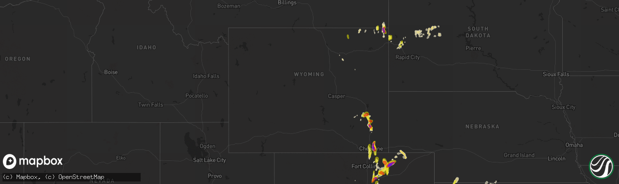
Hail Map in Wyoming on May 26, 2019
The weather event in Wyoming on May 26, 2019 includes Hail map. 21 states and 623 cities were impacted and suffered possible damage. The total estimated number of properties impacted is 9,956.
Want more than just the map?
Turn this storm into a full workflow.
- Owner + property data so you know who to knock
- OnDemand branded weather history reports to win the "did we even have hail?" argument
- RoofTrace estimate so reps stop guessing numbers at the door
Bought this map? Upgrade within 7 days and we'll credit the $230. (10-15 min setup call)
Hail
9,956
Estimated number of impacted properties by a 1.00" hail or larger5,103
Estimated number of impacted properties by a 1.75" hail or larger5,921
Estimated number of impacted properties by a 2.50" hail or largerStorm reports in Wyoming
Wyoming
| Date | Description |
|---|---|
| 05/26/20196:35 PM CDT | A local report indicates 2.00 inch wind near 5 E CHEYENNE |
| 05/26/20196:35 PM CDT | A local report indicates 1.75 inch wind near 2 ENE CHEYENNE |
| 05/26/20196:30 PM CDT | A local report indicates 2.75 inch wind near 5 E CHEYENNE |
| 05/26/20196:30 PM CDT | A local report indicates 1.00 inch wind near 1 S HILLSDALE |
| 05/26/20196:30 PM CDT | A local report indicates 1.50 inch wind near 1 E WHEATLAND |
| 05/26/20196:20 PM CDT | A local report indicates 4.25 inch wind near 5 E CHEYENNE |
| 05/26/20196:05 PM CDT | A local report indicates 1.00 inch wind near WHEATLAND |
| 05/26/20195:34 PM CDT | A local report indicates 1.00 inch wind near SPOTTED HORSE |
| 05/26/20194:30 PM CDT | Broken car windshield |
| 05/26/20194:30 PM CDT | Broken car windshield |
| 05/26/20197:33 AM CDT | At 1232 AM MDT, a severe thunderstorm was located 7 miles northeast of Nunn, or 24 miles northeast of Fort Collins, moving northeast at 25 mph. HAZARD...Half dollar size hail. SOURCE...Radar indicated. IMPACT...Damage to vehicles is expected. This severe thunderstorm will remain over mainly rural areas of northwestern Weld County. |
| 05/26/20191:45 AM CDT | At 645 PM MDT, a severe thunderstorm was located over Chugwater, or 20 miles southeast of Wheatland, moving southeast at 10 mph. HAZARD...Ping pong ball size hail and 60 mph wind gusts. SOURCE...Radar indicated. IMPACT...People and animals outdoors will be injured. Expect hail damage to roofs, siding, windows, and vehicles. Expect wind damage to roofs, siding, and trees. Locations impacted include... Chugwater and Slater. This includes Interstate 25 in Wyoming between mile markers 42 and61. |
| 05/26/20191:12 AM CDT | At 611 PM MDT, a severe thunderstorm was located near Slater, or 12 miles south of Wheatland, moving south at 15 mph. HAZARD...60 mph wind gusts and half dollar size hail. SOURCE...Radar indicated. IMPACT...Hail damage to vehicles is expected. Expect wind damage to roofs, siding, and trees. Locations impacted include... Chugwater and Slater. This includes Interstate 25 in Wyoming between mile markers 54 and68. |
| 05/26/201912:49 AM CDT | At 549 PM MDT, a severe thunderstorm was located over Bordeaux, or 7 miles southeast of Wheatland, moving south at 15 mph. HAZARD...60 mph wind gusts and quarter size hail. SOURCE...Radar indicated. IMPACT...Hail damage to vehicles is expected. Expect wind damage to roofs, siding, and trees. Locations impacted include... Bordeaux and Slater. This includes Interstate 25 in Wyoming between mile markers 58 and74. |
| 05/26/201912:35 AM CDT | At 534 PM MDT, public reported golf ball size hail east of Cheyenne. A severe thunderstorm was located near Ranchettes, or near Cheyenne, moving north at 30 mph. HAZARD...Golf ball size hail and 60 mph wind gusts. SOURCE...Public. IMPACT...People and animals outdoors will be injured. Expect hail damage to roofs, siding, windows, and vehicles. Expect wind damage to roofs, siding, and trees. Locations impacted include... Cheyenne, North Cheyenne, Whitaker, Ranchettes and Fox Farm-College.This includes the following highways... Interstate 25 in Wyoming between mile markers 26 and 34. Interstate 80 in Wyoming between mile markers 364 and 374. |
| 05/26/201912:33 AM CDT | At 533 PM MDT, a severe thunderstorm was located 7 miles south of Carr, or 19 miles northeast of Fort Collins, moving north at 20 mph. HAZARD...60 mph wind gusts and quarter size hail. SOURCE...Radar indicated. IMPACT...Expect damage to roofs, siding, and trees. Hail damage to vehicles is expected. Locations impacted include... Carr, Rockport and Natural Fort. |
| 05/26/201912:29 AM CDT | At 529 PM MDT, a severe thunderstorm was located over Chugcreek, or near Wheatland, moving southeast at 15 mph. HAZARD...60 mph wind gusts and quarter size hail. SOURCE...Radar indicated. IMPACT...Hail damage to vehicles is expected. Expect wind damage to roofs, siding, and trees. Locations impacted include... Wheatland, Chugcreek, Y-O Ranch and Slater. This includes Interstate 25 in Wyoming between mile markers 65 and68. |
| 05/26/201912:15 AM CDT | At 505 PM MDT, the public reported quarter size hail in Wheatland. A severe thunderstorm was located over Lakeview North, or near Wheatland, moving southeast at 5 mph. HAZARD...60 mph wind gusts and quarter size hail. SOURCE...Public. IMPACT...Hail damage to vehicles is expected. Expect wind damage to roofs, siding, and trees. Locations impacted include... Wheatland, Chugcreek, Lakeview North, Bordeaux, Y-O Ranch and Slater.This includes Interstate 25 in Wyoming between mile markers 70 and84. |
| 05/25/201911:42 PM CDT | At 442 PM MDT, a severe thunderstorm was located over Lakeview North, or near Wheatland, moving southeast at 5 mph. HAZARD...60 mph wind gusts and quarter size hail. SOURCE...Radar indicated. IMPACT...Hail damage to vehicles is expected. Expect wind damage to roofs, siding, and trees. Locations impacted include... Wheatland, Chugcreek, Lakeview North and Y-O Ranch. This includes Interstate 25 in Wyoming between mile markers 77 and86. |
| 05/25/201911:18 PM CDT | At 418 PM MDT, a severe thunderstorm was located 8 miles north of Lakeview North, or 11 miles north of Wheatland, moving east at 10 mph. HAZARD...60 mph wind gusts and half dollar size hail. SOURCE...Radar indicated. IMPACT...Hail damage to vehicles is expected. Expect wind damage to roofs, siding, and trees. Locations impacted include... Grayrocks Reservoir and Lakeview North. This includes Interstate 25 in Wyoming between mile markers 83 and89. |
| 05/25/201910:41 PM CDT | At 339 PM MDT, a severe thunderstorm was located 11 miles north of Lakeview North, or 14 miles north of Wheatland, moving northeast at 35 mph. HAZARD...Ping pong ball size hail and 60 mph wind gusts. SOURCE...Radar indicated. At 338 PM MDT, a spotter 15 miles north northwest of Wheatland reported quarter size hail. IMPACT...People and animals outdoors will be injured. Expect hail damage to roofs, siding, windows, and vehicles. Expect wind damage to roofs, siding, and trees. This severe thunderstorm will be near... Guernsey Campground around 405 PM MDT. Rawhide Buttes around 445 PM MDT.Other locations impacted by this severe thunderstorm includeHartville.This includes Interstate 25 in Wyoming between mile markers 87 and102. |
| 05/25/201910:33 PM CDT | At 332 PM MDT, a severe thunderstorm was located over Clareton, or 27 miles southwest of Newcastle, moving northeast at 25 mph. HAZARD...60 mph wind gusts and half dollar size hail. SOURCE...Radar indicated. IMPACT...Hail damage to vehicles is expected. Expect wind damage to roofs, siding, and trees. Locations impacted include... Clareton. |
| 05/25/201910:24 PM CDT | At 323 PM MDT, a severe thunderstorm was located 8 miles southeast of Alzada, or 28 miles northwest of Belle Fourche, moving north at 25 mph. HAZARD...Ping pong ball size hail and 60 mph wind gusts. SOURCE...Radar indicated. IMPACT...People and animals outdoors will be injured. Expect hail damage to roofs, siding, windows, and vehicles. Expect wind damage to roofs, siding, and trees. This severe thunderstorm will remain over mainly rural areas of northeastern Crook County. |
| 05/25/201910:18 PM CDT | At 318 PM MDT, a severe thunderstorm was located 8 miles west of Belle Fourche, moving north at 25 mph. HAZARD...Ping pong ball size hail and 60 mph wind gusts. SOURCE...Radar indicated. IMPACT...People and animals outdoors will be injured. Expect hail damage to roofs, siding, windows, and vehicles. Expect wind damage to roofs, siding, and trees. Locations impacted include... Northern Belle Fourche and Colony. |
| 05/25/201910:04 PM CDT | At 303 PM MDT, a severe thunderstorm was located 10 miles southeast of Harris Park, or 17 miles northwest of Wheatland, moving north at 20 mph. HAZARD...60 mph wind gusts and quarter size hail. SOURCE...Radar indicated. IMPACT...Hail damage to vehicles is expected. Expect wind damage to roofs, siding, and trees. This severe thunderstorm will be near... Sibley Peak around 350 PM MDT. Glendo, Glendo Reservoir and Two Moon Campground around 400 PM MDT.This includes Interstate 25 in Wyoming between mile markers 95 and113. |
| 05/25/20197:30 PM CDT | A local report indicates 1.75 inch wind near 5 N CHUGWATER |
| 05/25/20197:20 PM CDT | Reported at the f.e. Warren air force base campground. |
All States Impacted by Hail Map on May 26, 2019
Cities Impacted by Hail Map on May 26, 2019
- De Witt, NE
- Smithville, WV
- Big Springs, WV
- Auburn, WV
- Brohard, WV
- Sand Fork, WV
- Harrisville, WV
- Linn, WV
- Big Bend, WV
- Troy, WV
- Coxs Mills, WV
- Burnsville, WV
- Glenville, WV
- Fowler, KS
- Jonestown, PA
- Lebanon, PA
- Myerstown, PA
- The Plains, OH
- Athens, OH
- New Marshfield, OH
- Causey, NM
- Pep, NM
- Aberdeen, ID
- Brashear, MO
- Pampa, TX
- Dumas, TX
- Channing, TX
- Elizabeth, WV
- Palestine, WV
- Perryton, TX
- Canadian, TX
- Lipscomb, TX
- Follett, TX
- Higgins, TX
- Booker, TX
- Hereford, TX
- Mud Butte, SD
- Union Center, SD
- Almena, KS
- Mineral Wells, WV
- Parkersburg, WV
- Davisville, WV
- Walker, WV
- Leoti, KS
- Winona, KS
- Martell, NE
- Firth, NE
- Hallam, NE
- Hickman, NE
- Roca, NE
- Lincoln, NE
- Cortland, NE
- South Bloomingville, OH
- Chillicothe, OH
- Adelphi, OH
- Rockbridge, OH
- Laurelville, OH
- Kingston, OH
- Logan, OH
- Mosquero, NM
- Kirk, CO
- Joes, CO
- Cheyenne, WY
- New Raymer, CO
- McArthur, OH
- Wilkesville, OH
- Albany, OH
- Briggsdale, CO
- Rogers, NM
- Rixeyville, VA
- Culpeper, VA
- Carr, CO
- Reedy, WV
- Wiggins, CO
- Weldona, CO
- Orchard, CO
- Whitewood, SD
- Sturgis, SD
- Belle Fourche, SD
- Morgantown, WV
- Granville, WV
- Springview, NE
- Bladen, NE
- Ayr, NE
- Eads, CO
- Kit Carson, CO
- Sheridan Lake, CO
- Wiley, CO
- Hasty, CO
- Las Animas, CO
- McClave, CO
- Cheyenne Wells, CO
- Kim, CO
- Cedar Vale, KS
- Willow Wood, OH
- Glenwood, WV
- Crown City, OH
- Scottown, OH
- Lesage, WV
- Amarillo, TX
- New Plymouth, OH
- Stewart, OH
- Nelsonville, OH
- Guysville, OH
- Coolville, OH
- Clayton, NM
- Nunn, CO
- Burbank, WA
- Kaycee, WY
- Mayfield, KS
- Milan, KS
- Mcconnelsville, OH
- Caldwell, OH
- Scottsville, VA
- Long Pine, NE
- Mills, NE
- Bassett, NE
- Newport, NE
- Vale, SD
- Trenton, NE
- Padroni, CO
- Myersville, MD
- Colby, KS
- Le Roy, KS
- Westphalia, KS
- Frederick, MD
- Fairplay, MD
- Middletown, MD
- Keedysville, MD
- Williamsport, MD
- Boonsboro, MD
- Funkstown, MD
- Hagerstown, MD
- Dalhart, TX
- Denver, CO
- Aurora, CO
- Norton, KS
- Cumberland, OH
- Malta, OH
- White Hall, MD
- Grenville, NM
- Alzada, MT
- Eaton, CO
- Gill, CO
- Nazareth, TX
- Tulia, TX
- Owensboro, KY
- Lynch, NE
- Chugwater, WY
- Wheatland, WY
- Sterling, CO
- Dix, NE
- Kimball, NE
- Peetz, CO
- Mcalister, NM
- Grady, NM
- San Jon, NM
- Springfield, CO
- Hudson, CO
- Keenesburg, CO
- Pomeroy, OH
- Mason, WV
- Bidwell, OH
- Cheshire, OH
- Middleport, OH
- West Columbia, WV
- Hartford, WV
- Letart, WV
- Racine, OH
- Syracuse, OH
- Conchas Dam, NM
- Tucumcari, NM
- Osage, WV
- Kersey, CO
- Spearville, KS
- Accomac, VA
- Laverne, OK
- Grover, CO
- Roggen, CO
- New Haven, WV
- Milford, DE
- Upper Falls, MD
- Edgewood, MD
- Glen Arm, MD
- Kennedyville, MD
- Dover Afb, DE
- Viola, DE
- Worton, MD
- Kingsville, MD
- Fork, MD
- Hartly, DE
- Sudlersville, MD
- Aberdeen Proving Ground, MD
- Crumpton, MD
- Frederica, DE
- Marydel, DE
- Marydel, MD
- Woodside, DE
- Chestertown, MD
- Fallston, MD
- Clayton, DE
- Barclay, MD
- Hydes, MD
- Felton, DE
- Millington, MD
- Joppa, MD
- Dover, DE
- Galena, MD
- Gunpowder, MD
- Magnolia, DE
- Camden Wyoming, DE
- Baldwin, MD
- Palmyra, VA
- Stuart, NE
- Atkinson, NE
- Bruceton Mills, WV
- Parkton, MD
- Corydon, IN
- Rexford, KS
- Clovis, NM
- Sharon Springs, KS
- Roswell, NM
- Creola, OH
- Kinsley, KS
- Hulett, WY
- Douglass, KS
- Hugo, CO
- Ramah, CO
- Portales, NM
- Elida, NM
- Sudan, TX
- Weskan, KS
- Arapahoe, CO
- Kanorado, KS
- Goodland, KS
- Faith, SD
- Pierce, CO
- White Deer, TX
- Gordonsville, VA
- Troy, VA
- Louisa, VA
- Vona, CO
- Stratton, CO
- Anthony, KS
- Freeport, KS
- Bluff City, KS
- Sterling, KS
- Lyons, KS
- Gallipolis, OH
- Robards, KY
- Carmen, OK
- Goltry, OK
- Jet, OK
- Cherokee, OK
- Helena, OK
- Shattuck, OK
- Gage, OK
- Woodward, OK
- Arnett, OK
- Sharon, OK
- Fargo, OK
- Littleton, CO
- Aladdin, WY
- Minneola, KS
- Commerce City, CO
- English, IN
- Sulphur, IN
- McDonald, KS
- Stratton, NE
- Rush, CO
- Ordway, CO
- Little Hocking, OH
- Petroleum, WV
- Circleville, OH
- Washington, WV
- Point Pleasant, WV
- Montezuma, KS
- Plains, KS
- Bard, NM
- Broadview, NM
- Aylett, VA
- Greeley, CO
- Lake Lynn, PA
- Walkerton, VA
- Ruther Glen, VA
- Saint Stephens Church, VA
- Dodge City, KS
- Meade, KS
- Texline, TX
- Felt, OK
- Boise City, OK
- Olney Springs, CO
- Dimmitt, TX
- Hart, TX
- Ault, CO
- Minden, NE
- Wheeler, TX
- Briscoe, TX
- Lincoln, KS
- Spencer, WV
- Garrett, WY
- Bennett, CO
- Stinnett, TX
- Melrose, NM
- Happy, TX
- Wayside, TX
- Pond Creek, OK
- Watkins, CO
- Earth, TX
- Muleshoe, TX
- Claude, TX
- Weston, WY
- Russell, KS
- Copeland, KS
- Boulder, MT
- Medicine Lodge, KS
- Fritch, TX
- Borger, TX
- Evansville, IN
- Dupree, SD
- Sunray, TX
- Wildorado, TX
- Vega, TX
- Groom, TX
- Naponee, NE
- Republican City, NE
- Alma, NE
- Cimarron, KS
- Jetmore, KS
- Lamar, CO
- Boulder, CO
- Kanopolis, KS
- Ellsworth, KS
- Floyd, NM
- Ashton, NE
- Sylvan Grove, KS
- Hunter, KS
- Touchet, WA
- Fort Lupton, CO
- Wadesville, IN
- Nara Visa, NM
- Englewood, CO
- Sedgwick, KS
- Valley Center, KS
- Nash, OK
- Jennings, KS
- Dresden, KS
- Selden, KS
- Offerle, KS
- Miami, TX
- Atwood, KS
- Bird City, KS
- Ryegate, MT
- Berkeley Springs, WV
- Fredonia, KS
- Mooreland, OK
- Alva, OK
- Freedom, OK
- Blue Hill, NE
- Lawrence, NE
- Geuda Springs, KS
- South Haven, KS
- Panhandle, TX
- Logan, NM
- Onley, VA
- Onancock, VA
- Holdrege, NE
- Whitesville, KY
- Utica, KY
- Hartford, KY
- Texhoma, OK
- Goodwell, OK
- Cooksville, MD
- Woodbine, MD
- Westminster, MD
- Mount Airy, MD
- Sykesville, MD
- Brandenburg, KY
- Fe Warren Afb, WY
- Spencer, NE
- Oneill, NE
- Boyes, MT
- Amanda, OH
- Lancaster, OH
- Tarlton, OH
- Sandyville, WV
- Campo, CO
- Burden, KS
- Cambridge, KS
- Upland, NE
- Cottageville, WV
- Boone, CO
- Hedgesville, WV
- Monument, KS
- Holly, CO
- Cambridge, MD
- Madison, MD
- Manchester, OK
- Medford, OK
- White Owl, SD
- Howes, SD
- Edson, KS
- Corning, OH
- Crooksville, OH
- New Lexington, OH
- Argonia, KS
- Masterson, TX
- Sugar Grove, OH
- Larned, KS
- Roy, NM
- Solano, NM
- Atlanta, KS
- Platteville, CO
- La Salle, CO
- Brighton, CO
- Taylors Island, MD
- Tribune, KS
- Long Island, KS
- Shady Side, MD
- Churchton, MD
- Great Bend, KS
- Claflin, KS
- Ellinwood, KS
- Maidsville, WV
- Pursglove, WV
- Prairie View, KS
- Smithsburg, MD
- Elizabeth, CO
- Waynoka, OK
- Deadwood, SD
- Fort Meade, SD
- Caldwell, KS
- Adrian, TX
- Ward, CO
- Dexter, KS
- Lone Tree, CO
- Catonsville, MD
- Halethorpe, MD
- Baltimore, MD
- Ellicott City, MD
- Amorita, OK
- Phillipsburg, KS
- Bloomington, NE
- Bobtown, PA
- Dilliner, PA
- Greensboro, PA
- Guymon, OK
- Wellington, KS
- Seibert, CO
- Herrin, IL
- Carterville, IL
- Le Roy, WV
- Waldron, KS
- Canyon, TX
- Beaver City, NE
- Flagler, CO
- Arriba, CO
- Karval, CO
- Fowler, CO
- Munday, WV
- Macfarlan, WV
- Mount Alto, WV
- Millwood, WV
- Moorcroft, WY
- Linthicum Heights, MD
- Brooklyn, MD
- Glen Burnie, MD
- Spearman, TX
- Beaver, OK
- Gem, KS
- Burlington, OK
- Creston, WV
- Elm Creek, NE
- Johnstown, NE
- Liberal, KS
- Holstein, NE
- Shade, OH
- Emmitsburg, MD
- Thurmont, MD
- Keymar, MD
- Rocky Ridge, MD
- Franklin, NE
- Hildreth, NE
- Wilcox, NE
- Hooker, OK
- Tyrone, OK
- Mclean, TX
- Carmi, IL
- Genoa, CO
- Two Buttes, CO
- Glenvil, NE
- Roseland, NE
- Grinnell, KS
- Abingdon, MD
- Massey, MD
- Arkansas City, KS
- Maple City, KS
- Shidler, OK
- Campbell, NE
- Shamrock, TX
- Philippi, WV
- Winfield, KS
- Erie, KS
- Saint Paul, KS
- Mobeetie, TX
- Lorraine, KS
- Hallwood, VA
- Temperanceville, VA
- Sanford, VA
- Partlow, VA
- Wright, KS
- Saint Croix, IN
- Leavenworth, IN
- Garden City, KS
- Kents Store, VA
- Keswick, VA
- Wilson, KS
- Parksley, VA
- Bloxom, VA
- Dacoma, OK
- Spearfish, SD
- Clatonia, NE
- New Windsor, MD
- Union Bridge, MD
- Woodstock, MD
- Marriottsville, MD
- New Market, MD
- Newell, SD
- Ray, OH
- Londonderry, OH
- Woodford, VA
- St John, KS
- Union, NE
- Albright, WV
- Jarrettsville, MD
- Monkton, MD
- Oakley, KS
- Geneseo, KS
- Chase, KS
- Webster, KY
- Payneville, KY
- Murdock, KS
- Belleville, WV
- Reedsville, OH
- Ravenswood, WV
- Long Bottom, OH
- Melfa, VA
- Bushton, KS
- Des Moines, NM
- Hardesty, OK
- Fredericksburg, PA
- Annville, PA
- Newmanstown, PA
- Depauw, IN
- Littleton, WV
- Beloit, KS
- Enfield, IL
- Kenton, OK
- Sublette, KS
- Sedan, KS
- Turpin, OK
- Pritchett, CO
- Shawnee, OH
- Lititz, PA
- Schaefferstown, PA
- Ono, PA
- Danbury, NE
- Spotsylvania, VA
- Clarendon, TX
- Clayton, KS
- Oberlin, KS
- Balko, OK
- Lamont, OK
- Nebo, WV
- Chloe, WV
- Wright, WY
- Ainsworth, NE
- Hartley, TX
- Walsenburg, CO
- Sylvia, KS
- Udall, KS
- Mulvane, KS
- Portland, OH
- Leon, WV
- Hudson, KS
- Mankato, KS
- Plainville, KS
- Orleans, NE
- Rockport, WV
- Charlottesville, VA
- Keene, VA
- Esmont, VA
- Bremo Bluff, VA
- Kiowa, KS
- Hays, KS
- Cunningham, KS
- Elbert, CO
- Rose Hill, KS
- Ketchum, ID
- Hailey, ID
- Aberdeen, MD
- Still Pond, MD
- Betterton, MD
- Springlake, TX
- Millfield, OH
- Amesville, OH
- Arvada, WY
- Gillette, WY
- Butte, NE
- Colorado Springs, CO
- Usaf Academy, CO
- Yoder, CO
- Evans, CO
- Louviers, CO
- Livingston, MT
- Rapelje, MT
- Big Timber, MT
- Shepherd, MT
- Billings, MT
- Musselshell, MT
- Roundup, MT
- Crow Agency, MT
- Saint Xavier, MT


