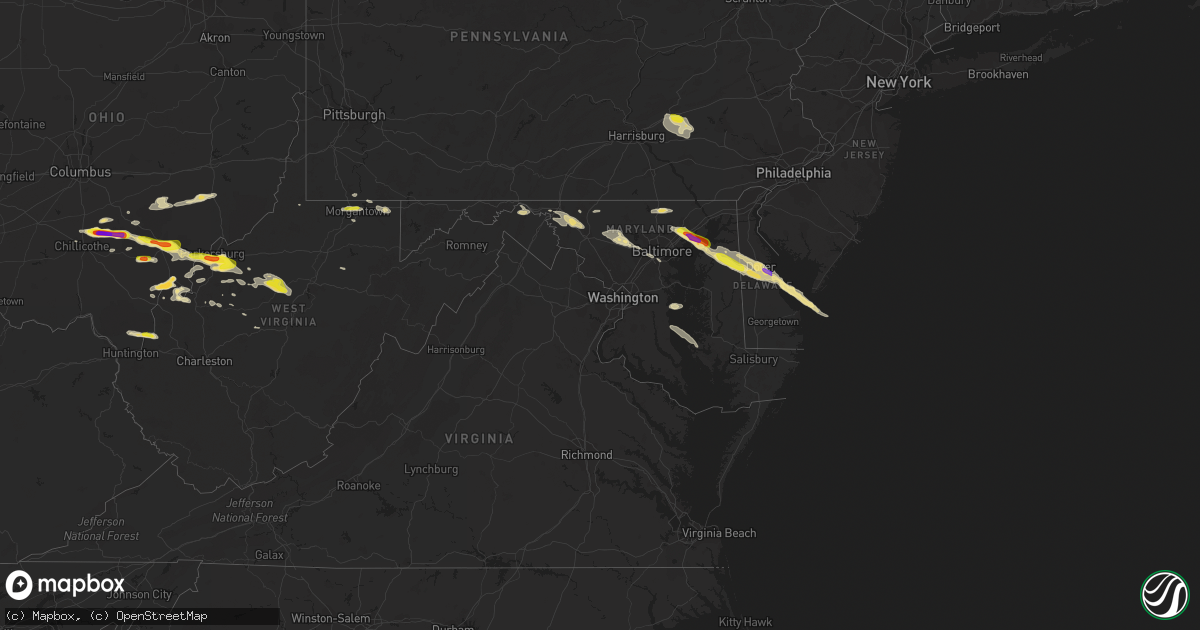
Hail Map in Maryland on May 26, 2019
Get this storm
May 26 map
$229
one time, instant access
Download today. No call, no setup
Keep the $229
Bought the map and want the full workflow? Apply the entire $229 to a subscription within 7 days. None of it is wasted.
Every map, not just this one
This buys you this map. Subscription and you get every map we run, in the markets you choose from a few cities to whole states to nationwide. Plus real-time alerts the moment a storm fires.
Contact data
Name, contact info, occupancy, even credit band for addresses in the footprint. You go from where it hit to who to call.
Become the source they trust
Unlimited branding weather history reports on demand. You already have the documented answer ready for the property owner, and you are the one who showed up with it.
Property data and RoofTrace estimates
Pull up any address you have got, its value and the exact code rules for that jurisdiction, straight from One Click Code. Then RoofTrace estimates the squares, pitch, and roof value, priced the way you price.
Storm reports in Maryland
Maryland
| Date | Description |
|---|---|
| 05/26/20194:35 AM CDT | At 935 PM EDT, a severe thunderstorm was located over Arbutus, or near Baltimore, moving southeast at 35 mph. HAZARD...60 mph wind gusts and quarter size hail. SOURCE...Radar indicated. IMPACT...Damaging winds will cause some trees and large branches to fall. This could injure those outdoors, as well as damage homes and vehicles. Roadways may become blocked by downed trees. Localized power outages are possible. Unsecured light objects may become projectiles. Locations impacted include... Baltimore, Columbia, Severn, Pikesville, Middle River, Elkridge, Riviera Beach, Baltimore-Washington Airport, Bodkin Point, Sillery Bay, Millers Island, North Point State Park, Sparrows Point, Back River, Glen Burnie, Ellicott City, Dundalk, Catonsville, Essex and Woodlawn. |
| 05/26/20193:59 AM CDT | At 858 PM EDT, a severe thunderstorm was located near Sykesville, or 11 miles northeast of Damascus, moving east at 40 mph. HAZARD...60 mph wind gusts and quarter size hail. SOURCE...Emergency management reported trees down in Frederick County in Lewistown at 826 PM. IMPACT...Damaging winds will cause some trees and large branches to fall. This could injure those outdoors, as well as damage homes and vehicles. Roadways may become blocked by downed trees. Localized power outages are possible. Unsecured light objects may become projectiles. Locations impacted include... Baltimore, Columbia, Pikesville, Elkridge, Ellicott City, Towson, Catonsville, Woodlawn, Randallstown, Parkville, Owings Mills, Eldersburg, Milford Mill, Reisterstown, Lochearn, Arbutus, Brooklyn Park, Mount Airy, Sykesville and Oakland. |
| 05/26/20193:46 AM CDT | At 846 PM EDT, a severe thunderstorm was located near Pleasant Hills, or 8 miles northeast of Middle River, moving east at 40 mph. HAZARD...60 mph wind gusts and quarter size hail. SOURCE...Radar indicated. IMPACT...Damaging winds will cause some trees and large branches to fall. This could injure those outdoors, as well as damage homes and vehicles. Roadways may become blocked by downed trees. Localized power outages are possible. Unsecured light objects may become projectiles. Locations impacted include... Aberdeen, Aberdeen Proving Ground, Bel Air South, Bel Air North, Perry Hall, White Marsh, Fallston, Riverside, Kingsville, Pleasant Hills, Perryman, Edgewood, Joppatowne, Benson, Magnolia, Chase, Bradshaw, Harford Furnace, Abingdon and Joppa. |
| 05/26/20193:21 AM CDT | At 821 PM EDT, a severe thunderstorm was located near Wolfsville, or 7 miles northwest of Frederick, moving east at 35 mph. HAZARD...60 mph wind gusts and quarter size hail. SOURCE...Radar indicated. IMPACT...Damaging winds will cause some trees and large branches to fall. This could injure those outdoors, as well as damage homes and vehicles. Roadways may become blocked by downed trees. Localized power outages are possible. Unsecured light objects may become projectiles. Locations impacted include... Frederick, Westminster, Thurmont, Harry Grove Stadium, Eldersburg, Ballenger Creek, Mount Airy, Walkersville, Sykesville, Braddock Heights, New Market, Gamber, Clover Hill, Discovery-Spring Garden, Green Valley, Wolfsville, Linganore-Bartonsville, Myersville, New Windsor and Woodsboro. |
| 05/26/20193:11 AM CDT | At 811 PM EDT, a severe thunderstorm was located near Emmitsburg, moving east at 15 mph. HAZARD...60 mph wind gusts and quarter size hail. SOURCE...Radar indicated. IMPACT...Damaging winds will cause some trees and large branches to fall. This could injure those outdoors, as well as damage homes and vehicles. Roadways may become blocked by downed trees. Localized power outages are possible. Unsecured light objects may become projectiles. Locations impacted include... Westminster, Thurmont, Emmitsburg, Taneytown, New Windsor, Union Bridge, New Midway, Ladiesburg, Rocky Ridge, Linwood, Detour, Uniontown, Wagners Mill, Keysville, Keymar and Graceham. |
| 05/26/20193:07 AM CDT | At 807 PM EDT, a severe thunderstorm was located near Jarrettsville, or 12 miles north of Cockeysville, moving east at 30 mph. HAZARD...60 mph wind gusts and quarter size hail. SOURCE...Radar indicated. IMPACT...Damaging winds will cause some trees and large branches to fall. This could injure those outdoors, as well as damage homes and vehicles. Roadways may become blocked by downed trees. Localized power outages are possible. Unsecured light objects may become projectiles. Locations impacted include... Bel Air South, Bel Air North, Fallston, Pleasant Hills, Jarrettsville, Edgewood, Pylesville, Cardiff, Benson, Norrisville, Scarboro, Forest Hill, Chrome Hill, Bynum, Street, Rocks, Hereford, Monkton, Hickory and Whiteford. |
| 05/26/20192:05 AM CDT | At 705 PM EDT, a severe thunderstorm was located over Kent Point, or near Shady Side, moving east at 30 mph. HAZARD...60 mph wind gusts and quarter size hail. SOURCE...Radar indicated. IMPACT...Minor damage to vehicles is possible. Wind damage to roofs, siding, trees, and power lines is possible. Locations impacted include... Easton, Talbot, Romancoke, Trappe, St. Michaels, Oxford, Wye Mills, Tilghman Island, Hambleton, Skipton, Copperville and Cordova. |
| 05/26/20191:35 AM CDT | At 635 PM EDT, a severe thunderstorm was located near Marlton, or near Upper Marlboro, moving east at 20 mph. HAZARD...60 mph wind gusts and quarter size hail. SOURCE...Radar indicated. IMPACT...Damaging winds will cause some trees and large branches to fall. This could injure those outdoors, as well as damage homes and vehicles. Roadways may become blocked by downed trees. Localized power outages are possible. Unsecured light objects may become projectiles. Locations impacted include... Shady Side, Chesapeake Beach, Deale, Marlton, Dunkirk, Owings, Friendship, Mount Harmony and Tracys Landing. |
| 05/25/201911:56 PM CDT | At 456 PM EDT, a severe thunderstorm was located near Taylors Island, moving east at 30 mph. HAZARD...60 mph wind gusts and quarter size hail. SOURCE...Radar indicated. IMPACT...Minor damage to vehicles is possible. Expect wind damage to trees and powerlines. This severe thunderstorm will be near, University Of Maryland Center For Environmental Studies around 510 PM EDT. Cambridge around 515 PM EDT.Other locations impacted by this severe thunderstorm include Madison,Taylors Island, Woolford, Andrews, Hudson, Church Creek, Bucktown andLloyds. |
| 05/25/20199:33 PM CDT | Delayed report. Power lines down near centreville from thunderstorm wind gusts. Time estimated from radar. |
| 05/25/20198:58 PM CDT | Delayed report. Blown debris from straight-line thunderstorm wind gusts forced the closure of state highway 302 at woodyard road. Time estimated from radar. |
| 05/25/20198:58 PM CDT | Tree down near intersection of herald harbor road and wilson road. Second tree down nearby at intersection of herald harbor road and rosewood trail |
| 05/25/20198:58 PM CDT | Tree down near i-97 and generals highway |
| 05/25/20198:55 PM CDT | Tree down near intersection of sunrise beach road and whitneys landing drive |
| 05/25/20198:55 PM CDT | Tree down near intersection of waterbury road and severn chapel road |
| 05/25/20198:47 PM CDT | Delayed report. Downed utility forced the closure of state highway 313 between state highway 300 and state highway 544. Time estimated from radar. |
| 05/25/20198:47 PM CDT | Delayed report. Downed utility forced the closure of state highway 313 between groff road and state highway 544. Time estimated from radar. |
| 05/25/20198:45 PM CDT | Several reports of trees down between crumpton and sudlersville. Time estimated from radar. |
| 05/25/20198:35 PM CDT | Multiple trees down in halethorpe |
| 05/25/20198:30 PM CDT | Numerous trees down including onto state route 291. Time estimated from radar. |
| 05/25/20198:29 PM CDT | Tree down in poplar hill |
| 05/25/20198:25 PM CDT | Storm survey concluded that straight line winds estimated to 75 mph impacted the area of worton and still pond. Numerous large tree limbs were downed... With a number o |
| 05/25/20198:23 PM CDT | Several reports of trees down in the area. Small hail was also reported as the storm passed through. |
| 05/25/20198:16 PM CDT | Tree down on liberty road |
| 05/25/20198:15 PM CDT | 7-10 trees uprooted or snapped on 2 adjacent properties. One large tree fell across the road. Another destroyed a metal fence and multiple holly trees. Numerous large a |
| 05/25/20198:13 PM CDT | Multiple trees down... Barn displaced from its foundation along tunnell road between henryton road and marriottsville road |
| 05/25/20197:53 PM CDT | Tree reported down on haverhill road near joppa farm road. |
| 05/25/20197:52 PM CDT | Tree down on trimble road and erwin drive. |
| 05/25/20197:48 PM CDT | Tree down on the 1000 block of plaza circle. |
| 05/25/20197:26 PM CDT | Tree down on monroe street near rt. 34. |
| 05/25/20197:26 PM CDT | Trees down in the lewistown area of frederick county. |
| 05/25/20197:13 PM CDT | Trees reported down near emmitsburg. |
| 05/25/20197:13 PM CDT | Large branches down in myersville. |
| 05/25/20197:07 PM CDT | Tree down on vernon rd. |
All States Impacted by Hail Map on May 26, 2019
Cities Impacted by Hail Map on May 26, 2019
- De Witt, NE
- Smithville, WV
- Big Springs, WV
- Auburn, WV
- Brohard, WV
- Sand Fork, WV
- Harrisville, WV
- Linn, WV
- Big Bend, WV
- Troy, WV
- Coxs Mills, WV
- Burnsville, WV
- Glenville, WV
- Fowler, KS
- Jonestown, PA
- Lebanon, PA
- Myerstown, PA
- The Plains, OH
- Athens, OH
- New Marshfield, OH
- Causey, NM
- Pep, NM
- Aberdeen, ID
- Brashear, MO
- Pampa, TX
- Dumas, TX
- Channing, TX
- Elizabeth, WV
- Palestine, WV
- Perryton, TX
- Canadian, TX
- Lipscomb, TX
- Follett, TX
- Higgins, TX
- Booker, TX
- Hereford, TX
- Mud Butte, SD
- Union Center, SD
- Almena, KS
- Mineral Wells, WV
- Parkersburg, WV
- Davisville, WV
- Walker, WV
- Leoti, KS
- Winona, KS
- Martell, NE
- Firth, NE
- Hallam, NE
- Hickman, NE
- Roca, NE
- Lincoln, NE
- Cortland, NE
- South Bloomingville, OH
- Chillicothe, OH
- Adelphi, OH
- Rockbridge, OH
- Laurelville, OH
- Kingston, OH
- Logan, OH
- Mosquero, NM
- Kirk, CO
- Joes, CO
- Cheyenne, WY
- New Raymer, CO
- McArthur, OH
- Wilkesville, OH
- Albany, OH
- Briggsdale, CO
- Rogers, NM
- Rixeyville, VA
- Culpeper, VA
- Carr, CO
- Reedy, WV
- Wiggins, CO
- Weldona, CO
- Orchard, CO
- Whitewood, SD
- Sturgis, SD
- Belle Fourche, SD
- Morgantown, WV
- Granville, WV
- Springview, NE
- Bladen, NE
- Ayr, NE
- Eads, CO
- Kit Carson, CO
- Sheridan Lake, CO
- Wiley, CO
- Hasty, CO
- Las Animas, CO
- McClave, CO
- Cheyenne Wells, CO
- Kim, CO
- Cedar Vale, KS
- Willow Wood, OH
- Glenwood, WV
- Crown City, OH
- Scottown, OH
- Lesage, WV
- Amarillo, TX
- New Plymouth, OH
- Stewart, OH
- Nelsonville, OH
- Guysville, OH
- Coolville, OH
- Clayton, NM
- Nunn, CO
- Burbank, WA
- Kaycee, WY
- Mayfield, KS
- Milan, KS
- Mcconnelsville, OH
- Caldwell, OH
- Scottsville, VA
- Long Pine, NE
- Mills, NE
- Bassett, NE
- Newport, NE
- Vale, SD
- Trenton, NE
- Padroni, CO
- Myersville, MD
- Colby, KS
- Le Roy, KS
- Westphalia, KS
- Frederick, MD
- Fairplay, MD
- Middletown, MD
- Keedysville, MD
- Williamsport, MD
- Boonsboro, MD
- Funkstown, MD
- Hagerstown, MD
- Dalhart, TX
- Denver, CO
- Aurora, CO
- Norton, KS
- Cumberland, OH
- Malta, OH
- White Hall, MD
- Grenville, NM
- Alzada, MT
- Eaton, CO
- Gill, CO
- Nazareth, TX
- Tulia, TX
- Owensboro, KY
- Lynch, NE
- Chugwater, WY
- Wheatland, WY
- Sterling, CO
- Dix, NE
- Kimball, NE
- Peetz, CO
- Mcalister, NM
- Grady, NM
- San Jon, NM
- Springfield, CO
- Hudson, CO
- Keenesburg, CO
- Pomeroy, OH
- Mason, WV
- Bidwell, OH
- Cheshire, OH
- Middleport, OH
- West Columbia, WV
- Hartford, WV
- Letart, WV
- Racine, OH
- Syracuse, OH
- Conchas Dam, NM
- Tucumcari, NM
- Osage, WV
- Kersey, CO
- Spearville, KS
- Accomac, VA
- Laverne, OK
- Grover, CO
- Roggen, CO
- New Haven, WV
- Milford, DE
- Upper Falls, MD
- Edgewood, MD
- Glen Arm, MD
- Kennedyville, MD
- Dover Afb, DE
- Viola, DE
- Worton, MD
- Kingsville, MD
- Fork, MD
- Hartly, DE
- Sudlersville, MD
- Aberdeen Proving Ground, MD
- Crumpton, MD
- Frederica, DE
- Marydel, DE
- Marydel, MD
- Woodside, DE
- Chestertown, MD
- Fallston, MD
- Clayton, DE
- Barclay, MD
- Hydes, MD
- Felton, DE
- Millington, MD
- Joppa, MD
- Dover, DE
- Galena, MD
- Gunpowder, MD
- Magnolia, DE
- Camden Wyoming, DE
- Baldwin, MD
- Palmyra, VA
- Stuart, NE
- Atkinson, NE
- Bruceton Mills, WV
- Parkton, MD
- Corydon, IN
- Rexford, KS
- Clovis, NM
- Sharon Springs, KS
- Roswell, NM
- Creola, OH
- Kinsley, KS
- Hulett, WY
- Douglass, KS
- Hugo, CO
- Ramah, CO
- Portales, NM
- Elida, NM
- Sudan, TX
- Weskan, KS
- Arapahoe, CO
- Kanorado, KS
- Goodland, KS
- Faith, SD
- Pierce, CO
- White Deer, TX
- Gordonsville, VA
- Troy, VA
- Louisa, VA
- Vona, CO
- Stratton, CO
- Anthony, KS
- Freeport, KS
- Bluff City, KS
- Sterling, KS
- Lyons, KS
- Gallipolis, OH
- Robards, KY
- Carmen, OK
- Goltry, OK
- Jet, OK
- Cherokee, OK
- Helena, OK
- Shattuck, OK
- Gage, OK
- Woodward, OK
- Arnett, OK
- Sharon, OK
- Fargo, OK
- Littleton, CO
- Aladdin, WY
- Minneola, KS
- Commerce City, CO
- English, IN
- Sulphur, IN
- McDonald, KS
- Stratton, NE
- Rush, CO
- Ordway, CO
- Little Hocking, OH
- Petroleum, WV
- Circleville, OH
- Washington, WV
- Point Pleasant, WV
- Montezuma, KS
- Plains, KS
- Bard, NM
- Broadview, NM
- Aylett, VA
- Greeley, CO
- Lake Lynn, PA
- Walkerton, VA
- Ruther Glen, VA
- Saint Stephens Church, VA
- Dodge City, KS
- Meade, KS
- Texline, TX
- Felt, OK
- Boise City, OK
- Olney Springs, CO
- Dimmitt, TX
- Hart, TX
- Ault, CO
- Minden, NE
- Wheeler, TX
- Briscoe, TX
- Lincoln, KS
- Spencer, WV
- Garrett, WY
- Bennett, CO
- Stinnett, TX
- Melrose, NM
- Happy, TX
- Wayside, TX
- Pond Creek, OK
- Watkins, CO
- Earth, TX
- Muleshoe, TX
- Claude, TX
- Weston, WY
- Russell, KS
- Copeland, KS
- Boulder, MT
- Medicine Lodge, KS
- Fritch, TX
- Borger, TX
- Evansville, IN
- Dupree, SD
- Sunray, TX
- Wildorado, TX
- Vega, TX
- Groom, TX
- Naponee, NE
- Republican City, NE
- Alma, NE
- Cimarron, KS
- Jetmore, KS
- Lamar, CO
- Boulder, CO
- Kanopolis, KS
- Ellsworth, KS
- Floyd, NM
- Ashton, NE
- Sylvan Grove, KS
- Hunter, KS
- Touchet, WA
- Fort Lupton, CO
- Wadesville, IN
- Nara Visa, NM
- Englewood, CO
- Sedgwick, KS
- Valley Center, KS
- Nash, OK
- Jennings, KS
- Dresden, KS
- Selden, KS
- Offerle, KS
- Miami, TX
- Atwood, KS
- Bird City, KS
- Ryegate, MT
- Berkeley Springs, WV
- Fredonia, KS
- Mooreland, OK
- Alva, OK
- Freedom, OK
- Blue Hill, NE
- Lawrence, NE
- Geuda Springs, KS
- South Haven, KS
- Panhandle, TX
- Logan, NM
- Onley, VA
- Onancock, VA
- Holdrege, NE
- Whitesville, KY
- Utica, KY
- Hartford, KY
- Texhoma, OK
- Goodwell, OK
- Cooksville, MD
- Woodbine, MD
- Westminster, MD
- Mount Airy, MD
- Sykesville, MD
- Brandenburg, KY
- Fe Warren Afb, WY
- Spencer, NE
- Oneill, NE
- Boyes, MT
- Amanda, OH
- Lancaster, OH
- Tarlton, OH
- Sandyville, WV
- Campo, CO
- Burden, KS
- Cambridge, KS
- Upland, NE
- Cottageville, WV
- Boone, CO
- Hedgesville, WV
- Monument, KS
- Holly, CO
- Cambridge, MD
- Madison, MD
- Manchester, OK
- Medford, OK
- White Owl, SD
- Howes, SD
- Edson, KS
- Corning, OH
- Crooksville, OH
- New Lexington, OH
- Argonia, KS
- Masterson, TX
- Sugar Grove, OH
- Larned, KS
- Roy, NM
- Solano, NM
- Atlanta, KS
- Platteville, CO
- La Salle, CO
- Brighton, CO
- Taylors Island, MD
- Tribune, KS
- Long Island, KS
- Shady Side, MD
- Churchton, MD
- Great Bend, KS
- Claflin, KS
- Ellinwood, KS
- Maidsville, WV
- Pursglove, WV
- Prairie View, KS
- Smithsburg, MD
- Elizabeth, CO
- Waynoka, OK
- Deadwood, SD
- Fort Meade, SD
- Caldwell, KS
- Adrian, TX
- Ward, CO
- Dexter, KS
- Lone Tree, CO
- Catonsville, MD
- Halethorpe, MD
- Baltimore, MD
- Ellicott City, MD
- Amorita, OK
- Phillipsburg, KS
- Bloomington, NE
- Bobtown, PA
- Dilliner, PA
- Greensboro, PA
- Guymon, OK
- Wellington, KS
- Seibert, CO
- Herrin, IL
- Carterville, IL
- Le Roy, WV
- Waldron, KS
- Canyon, TX
- Beaver City, NE
- Flagler, CO
- Arriba, CO
- Karval, CO
- Fowler, CO
- Munday, WV
- Macfarlan, WV
- Mount Alto, WV
- Millwood, WV
- Moorcroft, WY
- Linthicum Heights, MD
- Brooklyn, MD
- Glen Burnie, MD
- Spearman, TX
- Beaver, OK
- Gem, KS
- Burlington, OK
- Creston, WV
- Elm Creek, NE
- Johnstown, NE
- Liberal, KS
- Holstein, NE
- Shade, OH
- Emmitsburg, MD
- Thurmont, MD
- Keymar, MD
- Rocky Ridge, MD
- Franklin, NE
- Hildreth, NE
- Wilcox, NE
- Hooker, OK
- Tyrone, OK
- Mclean, TX
- Carmi, IL
- Genoa, CO
- Two Buttes, CO
- Glenvil, NE
- Roseland, NE
- Grinnell, KS
- Abingdon, MD
- Massey, MD
- Arkansas City, KS
- Maple City, KS
- Shidler, OK
- Campbell, NE
- Shamrock, TX
- Philippi, WV
- Winfield, KS
- Erie, KS
- Saint Paul, KS
- Mobeetie, TX
- Lorraine, KS
- Hallwood, VA
- Temperanceville, VA
- Sanford, VA
- Partlow, VA
- Wright, KS
- Saint Croix, IN
- Leavenworth, IN
- Garden City, KS
- Kents Store, VA
- Keswick, VA
- Wilson, KS
- Parksley, VA
- Bloxom, VA
- Dacoma, OK
- Spearfish, SD
- Clatonia, NE
- New Windsor, MD
- Union Bridge, MD
- Woodstock, MD
- Marriottsville, MD
- New Market, MD
- Newell, SD
- Ray, OH
- Londonderry, OH
- Woodford, VA
- St John, KS
- Union, NE
- Albright, WV
- Jarrettsville, MD
- Monkton, MD
- Oakley, KS
- Geneseo, KS
- Chase, KS
- Webster, KY
- Payneville, KY
- Murdock, KS
- Belleville, WV
- Reedsville, OH
- Ravenswood, WV
- Long Bottom, OH
- Melfa, VA
- Bushton, KS
- Des Moines, NM
- Hardesty, OK
- Fredericksburg, PA
- Annville, PA
- Newmanstown, PA
- Depauw, IN
- Littleton, WV
- Beloit, KS
- Enfield, IL
- Kenton, OK
- Sublette, KS
- Sedan, KS
- Turpin, OK
- Pritchett, CO
- Shawnee, OH
- Lititz, PA
- Schaefferstown, PA
- Ono, PA
- Danbury, NE
- Spotsylvania, VA
- Clarendon, TX
- Clayton, KS
- Oberlin, KS
- Balko, OK
- Lamont, OK
- Nebo, WV
- Chloe, WV
- Wright, WY
- Ainsworth, NE
- Hartley, TX
- Walsenburg, CO
- Sylvia, KS
- Udall, KS
- Mulvane, KS
- Portland, OH
- Leon, WV
- Hudson, KS
- Mankato, KS
- Plainville, KS
- Orleans, NE
- Rockport, WV
- Charlottesville, VA
- Keene, VA
- Esmont, VA
- Bremo Bluff, VA
- Kiowa, KS
- Hays, KS
- Cunningham, KS
- Elbert, CO
- Rose Hill, KS
- Ketchum, ID
- Hailey, ID
- Aberdeen, MD
- Still Pond, MD
- Betterton, MD
- Springlake, TX
- Millfield, OH
- Amesville, OH
- Arvada, WY
- Gillette, WY
- Butte, NE
- Colorado Springs, CO
- Usaf Academy, CO
- Yoder, CO
- Evans, CO
- Louviers, CO
- Livingston, MT
- Rapelje, MT
- Big Timber, MT
- Shepherd, MT
- Billings, MT
- Musselshell, MT
- Roundup, MT
- Crow Agency, MT
- Saint Xavier, MT


