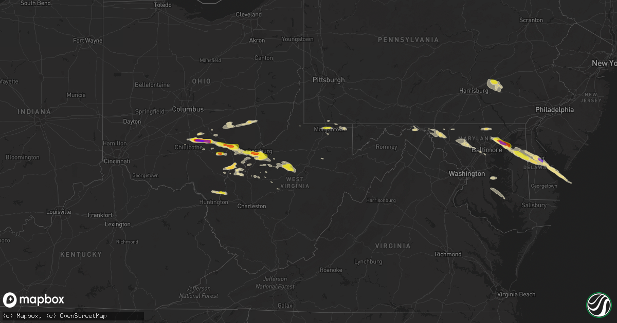
Hail Map in West Virginia on May 26, 2019
Get this storm
May 26 map
$229
one time, instant access
Download today. No call, no setup
Keep the $229
Bought the map and want the full workflow? Apply the entire $229 to a subscription within 7 days. None of it is wasted.
Every map, not just this one
This buys you this map. Subscription and you get every map we run, in the markets you choose from a few cities to whole states to nationwide. Plus real-time alerts the moment a storm fires.
Contact data
Name, contact info, occupancy, even credit band for addresses in the footprint. You go from where it hit to who to call.
Become the source they trust
Unlimited branding weather history reports on demand. You already have the documented answer ready for the property owner, and you are the one who showed up with it.
Property data and RoofTrace estimates
Pull up any address you have got, its value and the exact code rules for that jurisdiction, straight from One Click Code. Then RoofTrace estimates the squares, pitch, and roof value, priced the way you price.
Storm reports in West Virginia
West Virginia
| Date | Description |
|---|---|
| 05/26/20196:50 PM CDT | A local report indicates 1.00 inch wind near MORGANTOWN |
| 05/26/20196:42 PM CDT | Power outage due to tree out of row. Via outage map... Time estimated via radar. |
| 05/26/20196:20 PM CDT | Four trees down along triplet rd due to high wind. |
| 05/26/20196:15 PM CDT | Power outage due to tree damage. Via outage map... Time estimated via radar. |
| 05/26/20195:55 PM CDT | 2 trees down due to high wind on greenhills rd. |
| 05/26/20195:43 PM CDT | Several trees down due to high wind along flatwoods rd. |
| 05/26/20195:33 PM CDT | 1 inch diameter tree limbs broken. Shingles blown off a roof. Time estimated from radar |
| 05/26/20194:55 PM CDT | Multiple... Large... Healthy... Hardwood trees down across city. Basketball backboard and hoop blown from in-ground support. Pictures provided via twitter. |
| 05/26/20194:51 PM CDT | Picture of hail from mason. |
| 05/26/20194:10 PM CDT | Power outage due to tree damage. Via outage map... Time estimated via radar. |
| 05/26/20194:10 PM CDT | Power outage due to tree damage. Via outage map... Time estimated via radar. |
| 05/26/20194:05 PM CDT | Power outage due to tree damage. Via outage map... Time estimated via radar. |
| 05/26/20194:00 PM CDT | ** corrected time ** power outage due to tree damage. Via outage map... Time estimated via radar. |
| 05/26/20193:42 PM CDT | Power outage due to tree damage. Via outage map... Time estimated via radar. |
| 05/26/20193:40 PM CDT | Several trees down due to to high wind on rt 47 near smithville. |
| 05/26/20193:31 PM CDT | Power outage due to tree damage. Via outage map. |
| 05/26/20193:30 PM CDT | Power outage due to tree damage. Via outage map. |
| 05/26/20193:30 PM CDT | Estimated golf ball size hail reported by storm spotter in pettyville wv. |
| 05/26/20193:15 PM CDT | Power outage due to tree damage. Via outage map... Time estimated via radar. |
| 05/26/20193:15 PM CDT | A local report indicates 1.00 inch wind near WALKER |
| 05/26/20193:15 PM CDT | Power outage due to tree damage. Via outage map... Time estimated via radar. |
| 05/26/20193:07 PM CDT | Picture of two inch hail from davisville |
| 05/26/20193:07 PM CDT | Slightly larger than quarter size hail reported in davisville... Wv. |
| 05/26/20193:05 PM CDT | Corrects previous tstm wnd dmg report from 2 ssw davisville. 1 inch diameter tree limbs broken. Shingles blown off a roof. Time estimated from radar. |
| 05/26/20193:03 PM CDT | Corrects previous hail report from 2 nw mineralwells. Estimated golf ball size hail reported by storm spotter in pettyville wv. |
| 05/26/20195:13 AM CDT | At 1012 PM EDT, severe thunderstorms were located along a line extending from Laurel Branch to near Maggie to Fairlawn to near Byllesby, moving east at 60 mph. HAZARD...60 mph wind gusts. SOURCE...Radar indicated. IMPACT...Expect damage to roofs, siding, and trees. Locations impacted include... Roanoke... Blacksburg... Salem... Christiansburg... and Radford.This includes The following Locations Virginia Tech, The SalemFairgrounds, and Roanoke Regional Airport. |
| 05/26/20194:05 AM CDT | At 905 PM EDT, severe thunderstorms were located along a line extending from near Camp Creek State Park to near Gary to 8 miles west of Allison Gap, moving east at 45 mph. Trees have already been reported down in Richlands. HAZARD...60 mph wind gusts. SOURCE...Law enforcement. IMPACT...Expect damage to roofs, siding, and trees. Locations impacted include... Bluefield... Bland... Princeton... Richlands... and Tazewell.This includes The following Location Mercer County Airport. |
| 05/26/20193:40 AM CDT | At 839 PM EDT, a severe thunderstorm was located near Webster Springs, moving east at 50 mph. HAZARD...60 mph wind gusts and quarter size hail. SOURCE...Radar indicated. IMPACT...Hail damage to vehicles is expected. Expect wind damage to roofs, siding, and trees. Locations impacted include... Webster Springs, Addison (Webster Springs), Snowshoe, Mingo, Cowen, Diana, Monterville, Slaty Fork, Upper Glade, Waneta, Boggs, Valley Head, Bergoo and Erbacon. |
| 05/26/20193:27 AM CDT | At 825 PM EDT, a severe thunderstorm was located near Hancock, moving east at 20 mph. HAZARD...60 mph wind gusts and quarter size hail. SOURCE...Radar indicated. IMPACT...Damaging winds will cause some trees and large branches to fall. This could injure those outdoors, as well as damage homes and vehicles. Roadways may become blocked by downed trees. Localized power outages are possible. Unsecured light objects may become projectiles. Locations impacted include... Hagerstown, Wilson-Conococheague, Williamsport, Saint James, Halfway, Falling Waters, Fairplay, Clear Spring, Pecktonville, Big Spring, Big Pool, Cherry Run, Johnsontown and Spruce Pine Hollow. |
| 05/26/20193:13 AM CDT | At 813 PM EDT, a severe thunderstorm was located over Fishtrap Lake, or 9 miles east of Pikeville, moving east at 50 mph. HAZARD...60 mph wind gusts. SOURCE...Radar indicated. IMPACT...Expect damage to roofs, siding, and trees. Locations impacted include... Pikeville, Coal Run Village, Elkhorn City, Jamboree, Fishtrap Lake, Zebulon, Garden Village, Phyllis, Ashcamp, Toonerville, Marrowbone and Raccoon. |
| 05/26/20192:40 AM CDT | At 739 PM EDT, a severe thunderstorm was located over Granville, or over Star City, moving east at 35 mph. HAZARD...Wind gusts to 60 mph and quarter-size hail. SOURCE...Radar. IMPACT...Minor hail damage to vehicles is possible. Expect wind damage to trees and power lines, resulting in some power outages. Locations impacted include... Morgantown... Westover... Star City... Granville... Cassville... Brookhaven... Masontown... Brandonville... Bruceton Mills... Valley Point... Booth... Laurel Run...This includes the following highways... Interstate 68 in West Virginia between mile markers 1 and 25. Interstate 79 in West Virginia between mile markers 148 and 158. |
| 05/26/20192:40 AM CDT | At 740 PM EDT, a severe thunderstorm was located over Wilson-Conococheague, or near Hagerstown, moving southeast at 20 mph. HAZARD...60 mph wind gusts and quarter size hail. SOURCE...Radar indicated. IMPACT...Damaging winds will cause some trees and large branches to fall. This could injure those outdoors, as well as damage homes and vehicles. Roadways may become blocked by downed trees. Localized power outages are possible. Unsecured light objects may become projectiles. Locations impacted include... Hagerstown, Thurmont, Municipal Stadium, Robinwood, Fountainhead-Orchard Hills, Boonsboro, Smithsburg, Braddock Heights, Paramount-Long Meadow, Wilson-Conococheague, Williamsport, Mount Aetna, Mount Lena, San Mar, Long Meadow, Wolfsville, Saint James, Halfway, Maugansville and Myersville. |
| 05/26/20192:27 AM CDT | At 727 PM EDT, a severe thunderstorm was located over Oppy, or 10 miles northwest of Williamson, moving east at 50 mph. HAZARD...60 mph wind gusts. SOURCE...Radar indicated. IMPACT...Expect damage to roofs, siding, and trees. Locations impacted include... Inez, Warfield, Beauty, Rural, Moree, Pilgrim, Bradbury, Hatfield Station, Coalpoint, Whitepost, Hode and Oppy. |
| 05/26/20192:09 AM CDT | At 708 PM EDT, a severe thunderstorm was located 8 miles northwest of Spencer, moving east at 20 mph. HAZARD...60 mph wind gusts and quarter size hail. SOURCE...Radar indicated. IMPACT...Hail damage to vehicles is expected. Expect wind damage to roofs, siding, and trees. Locations impacted include... Spencer, Reedy, Annamoriah, Leroy and Gay.Torrential rainfall is also occurring with this storm, and may lead to flash flooding. Do not drive your vehicle through flooded roadways. |
| 05/26/20191:48 AM CDT | At 647 PM EDT, a severe thunderstorm was located near Racine, moving east at 25 mph. HAZARD...60 mph wind gusts and quarter size hail. SOURCE...Radar indicated. IMPACT...Hail damage to vehicles is expected. Expect wind damage to roofs, siding, and trees. Locations impacted include... Ripley, Racine, Ravenswood, Sandyville, Cottageville, Mount Alto, Evans, Leroy and Gay.This includes Interstate 77 in West Virginia between mile markers 134and 153.Torrential rainfall is occurring with this storm, and may lead to flash flooding. Do not drive your vehicle through flooded roadways. |
| 05/25/201911:28 PM CDT | At 427 PM EDT, a severe thunderstorm was located near North Bend State Park, or 8 miles southwest of Harrisville, moving east at 30 mph. HAZARD...60 mph wind gusts and quarter size hail. SOURCE...Radar indicated. IMPACT...Hail damage to vehicles is expected. Expect wind damage to roofs, siding, and trees. Locations impacted include... Harrisville, Elizabeth, North Bend State Park, Cairo, Pullman, Auburn, Smithville, Blandville, Baldwin, Avon, Grove, Leopold, Troy, New Milton, Newberne, Alum Bridge, Coxs Mills, Linn, Berea and Brohard. |
| 05/25/201910:52 PM CDT | At 352 PM EDT, a severe thunderstorm was located over Lubeck, or near Belpre, moving east at 30 mph. HAZARD...60 mph wind gusts and half dollar size hail. SOURCE...Radar indicated. IMPACT...Hail damage to vehicles is expected. Expect wind damage to roofs, siding, and trees. Locations impacted include... Parkersburg, Belpre, Vienna, Washington, Mineralwells, Lubeck, Walker, Nutter Farm, Petroleum, Schultz, Freeport, Blennerhassett, Davisville and Greencastle.This includes the following highways... Interstate 77 in West Virginia between mile markers 167 and 179. Route 50 in West Virginia between mile markers 1 and 29. |
| 05/25/20198:26 PM CDT | Numerous trees down mainly across the southern portion of the county. |
| 05/25/20197:50 PM CDT | A few large trees down due to high wind. |
| 05/25/20197:23 PM CDT | Pictures of tree blown down into and damaging a house. |
| 05/25/20197:00 PM CDT | Power outage due to weather - high winds |
All States Impacted by Hail Map on May 26, 2019
Cities Impacted by Hail Map on May 26, 2019
- De Witt, NE
- Smithville, WV
- Big Springs, WV
- Auburn, WV
- Brohard, WV
- Sand Fork, WV
- Harrisville, WV
- Linn, WV
- Big Bend, WV
- Troy, WV
- Coxs Mills, WV
- Burnsville, WV
- Glenville, WV
- Fowler, KS
- Jonestown, PA
- Lebanon, PA
- Myerstown, PA
- The Plains, OH
- Athens, OH
- New Marshfield, OH
- Causey, NM
- Pep, NM
- Aberdeen, ID
- Brashear, MO
- Pampa, TX
- Dumas, TX
- Channing, TX
- Elizabeth, WV
- Palestine, WV
- Perryton, TX
- Canadian, TX
- Lipscomb, TX
- Follett, TX
- Higgins, TX
- Booker, TX
- Hereford, TX
- Mud Butte, SD
- Union Center, SD
- Almena, KS
- Mineral Wells, WV
- Parkersburg, WV
- Davisville, WV
- Walker, WV
- Leoti, KS
- Winona, KS
- Martell, NE
- Firth, NE
- Hallam, NE
- Hickman, NE
- Roca, NE
- Lincoln, NE
- Cortland, NE
- South Bloomingville, OH
- Chillicothe, OH
- Adelphi, OH
- Rockbridge, OH
- Laurelville, OH
- Kingston, OH
- Logan, OH
- Mosquero, NM
- Kirk, CO
- Joes, CO
- Cheyenne, WY
- New Raymer, CO
- McArthur, OH
- Wilkesville, OH
- Albany, OH
- Briggsdale, CO
- Rogers, NM
- Rixeyville, VA
- Culpeper, VA
- Carr, CO
- Reedy, WV
- Wiggins, CO
- Weldona, CO
- Orchard, CO
- Whitewood, SD
- Sturgis, SD
- Belle Fourche, SD
- Morgantown, WV
- Granville, WV
- Springview, NE
- Bladen, NE
- Ayr, NE
- Eads, CO
- Kit Carson, CO
- Sheridan Lake, CO
- Wiley, CO
- Hasty, CO
- Las Animas, CO
- McClave, CO
- Cheyenne Wells, CO
- Kim, CO
- Cedar Vale, KS
- Willow Wood, OH
- Glenwood, WV
- Crown City, OH
- Scottown, OH
- Lesage, WV
- Amarillo, TX
- New Plymouth, OH
- Stewart, OH
- Nelsonville, OH
- Guysville, OH
- Coolville, OH
- Clayton, NM
- Nunn, CO
- Burbank, WA
- Kaycee, WY
- Mayfield, KS
- Milan, KS
- Mcconnelsville, OH
- Caldwell, OH
- Scottsville, VA
- Long Pine, NE
- Mills, NE
- Bassett, NE
- Newport, NE
- Vale, SD
- Trenton, NE
- Padroni, CO
- Myersville, MD
- Colby, KS
- Le Roy, KS
- Westphalia, KS
- Frederick, MD
- Fairplay, MD
- Middletown, MD
- Keedysville, MD
- Williamsport, MD
- Boonsboro, MD
- Funkstown, MD
- Hagerstown, MD
- Dalhart, TX
- Denver, CO
- Aurora, CO
- Norton, KS
- Cumberland, OH
- Malta, OH
- White Hall, MD
- Grenville, NM
- Alzada, MT
- Eaton, CO
- Gill, CO
- Nazareth, TX
- Tulia, TX
- Owensboro, KY
- Lynch, NE
- Chugwater, WY
- Wheatland, WY
- Sterling, CO
- Dix, NE
- Kimball, NE
- Peetz, CO
- Mcalister, NM
- Grady, NM
- San Jon, NM
- Springfield, CO
- Hudson, CO
- Keenesburg, CO
- Pomeroy, OH
- Mason, WV
- Bidwell, OH
- Cheshire, OH
- Middleport, OH
- West Columbia, WV
- Hartford, WV
- Letart, WV
- Racine, OH
- Syracuse, OH
- Conchas Dam, NM
- Tucumcari, NM
- Osage, WV
- Kersey, CO
- Spearville, KS
- Accomac, VA
- Laverne, OK
- Grover, CO
- Roggen, CO
- New Haven, WV
- Milford, DE
- Upper Falls, MD
- Edgewood, MD
- Glen Arm, MD
- Kennedyville, MD
- Dover Afb, DE
- Viola, DE
- Worton, MD
- Kingsville, MD
- Fork, MD
- Hartly, DE
- Sudlersville, MD
- Aberdeen Proving Ground, MD
- Crumpton, MD
- Frederica, DE
- Marydel, DE
- Marydel, MD
- Woodside, DE
- Chestertown, MD
- Fallston, MD
- Clayton, DE
- Barclay, MD
- Hydes, MD
- Felton, DE
- Millington, MD
- Joppa, MD
- Dover, DE
- Galena, MD
- Gunpowder, MD
- Magnolia, DE
- Camden Wyoming, DE
- Baldwin, MD
- Palmyra, VA
- Stuart, NE
- Atkinson, NE
- Bruceton Mills, WV
- Parkton, MD
- Corydon, IN
- Rexford, KS
- Clovis, NM
- Sharon Springs, KS
- Roswell, NM
- Creola, OH
- Kinsley, KS
- Hulett, WY
- Douglass, KS
- Hugo, CO
- Ramah, CO
- Portales, NM
- Elida, NM
- Sudan, TX
- Weskan, KS
- Arapahoe, CO
- Kanorado, KS
- Goodland, KS
- Faith, SD
- Pierce, CO
- White Deer, TX
- Gordonsville, VA
- Troy, VA
- Louisa, VA
- Vona, CO
- Stratton, CO
- Anthony, KS
- Freeport, KS
- Bluff City, KS
- Sterling, KS
- Lyons, KS
- Gallipolis, OH
- Robards, KY
- Carmen, OK
- Goltry, OK
- Jet, OK
- Cherokee, OK
- Helena, OK
- Shattuck, OK
- Gage, OK
- Woodward, OK
- Arnett, OK
- Sharon, OK
- Fargo, OK
- Littleton, CO
- Aladdin, WY
- Minneola, KS
- Commerce City, CO
- English, IN
- Sulphur, IN
- McDonald, KS
- Stratton, NE
- Rush, CO
- Ordway, CO
- Little Hocking, OH
- Petroleum, WV
- Circleville, OH
- Washington, WV
- Point Pleasant, WV
- Montezuma, KS
- Plains, KS
- Bard, NM
- Broadview, NM
- Aylett, VA
- Greeley, CO
- Lake Lynn, PA
- Walkerton, VA
- Ruther Glen, VA
- Saint Stephens Church, VA
- Dodge City, KS
- Meade, KS
- Texline, TX
- Felt, OK
- Boise City, OK
- Olney Springs, CO
- Dimmitt, TX
- Hart, TX
- Ault, CO
- Minden, NE
- Wheeler, TX
- Briscoe, TX
- Lincoln, KS
- Spencer, WV
- Garrett, WY
- Bennett, CO
- Stinnett, TX
- Melrose, NM
- Happy, TX
- Wayside, TX
- Pond Creek, OK
- Watkins, CO
- Earth, TX
- Muleshoe, TX
- Claude, TX
- Weston, WY
- Russell, KS
- Copeland, KS
- Boulder, MT
- Medicine Lodge, KS
- Fritch, TX
- Borger, TX
- Evansville, IN
- Dupree, SD
- Sunray, TX
- Wildorado, TX
- Vega, TX
- Groom, TX
- Naponee, NE
- Republican City, NE
- Alma, NE
- Cimarron, KS
- Jetmore, KS
- Lamar, CO
- Boulder, CO
- Kanopolis, KS
- Ellsworth, KS
- Floyd, NM
- Ashton, NE
- Sylvan Grove, KS
- Hunter, KS
- Touchet, WA
- Fort Lupton, CO
- Wadesville, IN
- Nara Visa, NM
- Englewood, CO
- Sedgwick, KS
- Valley Center, KS
- Nash, OK
- Jennings, KS
- Dresden, KS
- Selden, KS
- Offerle, KS
- Miami, TX
- Atwood, KS
- Bird City, KS
- Ryegate, MT
- Berkeley Springs, WV
- Fredonia, KS
- Mooreland, OK
- Alva, OK
- Freedom, OK
- Blue Hill, NE
- Lawrence, NE
- Geuda Springs, KS
- South Haven, KS
- Panhandle, TX
- Logan, NM
- Onley, VA
- Onancock, VA
- Holdrege, NE
- Whitesville, KY
- Utica, KY
- Hartford, KY
- Texhoma, OK
- Goodwell, OK
- Cooksville, MD
- Woodbine, MD
- Westminster, MD
- Mount Airy, MD
- Sykesville, MD
- Brandenburg, KY
- Fe Warren Afb, WY
- Spencer, NE
- Oneill, NE
- Boyes, MT
- Amanda, OH
- Lancaster, OH
- Tarlton, OH
- Sandyville, WV
- Campo, CO
- Burden, KS
- Cambridge, KS
- Upland, NE
- Cottageville, WV
- Boone, CO
- Hedgesville, WV
- Monument, KS
- Holly, CO
- Cambridge, MD
- Madison, MD
- Manchester, OK
- Medford, OK
- White Owl, SD
- Howes, SD
- Edson, KS
- Corning, OH
- Crooksville, OH
- New Lexington, OH
- Argonia, KS
- Masterson, TX
- Sugar Grove, OH
- Larned, KS
- Roy, NM
- Solano, NM
- Atlanta, KS
- Platteville, CO
- La Salle, CO
- Brighton, CO
- Taylors Island, MD
- Tribune, KS
- Long Island, KS
- Shady Side, MD
- Churchton, MD
- Great Bend, KS
- Claflin, KS
- Ellinwood, KS
- Maidsville, WV
- Pursglove, WV
- Prairie View, KS
- Smithsburg, MD
- Elizabeth, CO
- Waynoka, OK
- Deadwood, SD
- Fort Meade, SD
- Caldwell, KS
- Adrian, TX
- Ward, CO
- Dexter, KS
- Lone Tree, CO
- Catonsville, MD
- Halethorpe, MD
- Baltimore, MD
- Ellicott City, MD
- Amorita, OK
- Phillipsburg, KS
- Bloomington, NE
- Bobtown, PA
- Dilliner, PA
- Greensboro, PA
- Guymon, OK
- Wellington, KS
- Seibert, CO
- Herrin, IL
- Carterville, IL
- Le Roy, WV
- Waldron, KS
- Canyon, TX
- Beaver City, NE
- Flagler, CO
- Arriba, CO
- Karval, CO
- Fowler, CO
- Munday, WV
- Macfarlan, WV
- Mount Alto, WV
- Millwood, WV
- Moorcroft, WY
- Linthicum Heights, MD
- Brooklyn, MD
- Glen Burnie, MD
- Spearman, TX
- Beaver, OK
- Gem, KS
- Burlington, OK
- Creston, WV
- Elm Creek, NE
- Johnstown, NE
- Liberal, KS
- Holstein, NE
- Shade, OH
- Emmitsburg, MD
- Thurmont, MD
- Keymar, MD
- Rocky Ridge, MD
- Franklin, NE
- Hildreth, NE
- Wilcox, NE
- Hooker, OK
- Tyrone, OK
- Mclean, TX
- Carmi, IL
- Genoa, CO
- Two Buttes, CO
- Glenvil, NE
- Roseland, NE
- Grinnell, KS
- Abingdon, MD
- Massey, MD
- Arkansas City, KS
- Maple City, KS
- Shidler, OK
- Campbell, NE
- Shamrock, TX
- Philippi, WV
- Winfield, KS
- Erie, KS
- Saint Paul, KS
- Mobeetie, TX
- Lorraine, KS
- Hallwood, VA
- Temperanceville, VA
- Sanford, VA
- Partlow, VA
- Wright, KS
- Saint Croix, IN
- Leavenworth, IN
- Garden City, KS
- Kents Store, VA
- Keswick, VA
- Wilson, KS
- Parksley, VA
- Bloxom, VA
- Dacoma, OK
- Spearfish, SD
- Clatonia, NE
- New Windsor, MD
- Union Bridge, MD
- Woodstock, MD
- Marriottsville, MD
- New Market, MD
- Newell, SD
- Ray, OH
- Londonderry, OH
- Woodford, VA
- St John, KS
- Union, NE
- Albright, WV
- Jarrettsville, MD
- Monkton, MD
- Oakley, KS
- Geneseo, KS
- Chase, KS
- Webster, KY
- Payneville, KY
- Murdock, KS
- Belleville, WV
- Reedsville, OH
- Ravenswood, WV
- Long Bottom, OH
- Melfa, VA
- Bushton, KS
- Des Moines, NM
- Hardesty, OK
- Fredericksburg, PA
- Annville, PA
- Newmanstown, PA
- Depauw, IN
- Littleton, WV
- Beloit, KS
- Enfield, IL
- Kenton, OK
- Sublette, KS
- Sedan, KS
- Turpin, OK
- Pritchett, CO
- Shawnee, OH
- Lititz, PA
- Schaefferstown, PA
- Ono, PA
- Danbury, NE
- Spotsylvania, VA
- Clarendon, TX
- Clayton, KS
- Oberlin, KS
- Balko, OK
- Lamont, OK
- Nebo, WV
- Chloe, WV
- Wright, WY
- Ainsworth, NE
- Hartley, TX
- Walsenburg, CO
- Sylvia, KS
- Udall, KS
- Mulvane, KS
- Portland, OH
- Leon, WV
- Hudson, KS
- Mankato, KS
- Plainville, KS
- Orleans, NE
- Rockport, WV
- Charlottesville, VA
- Keene, VA
- Esmont, VA
- Bremo Bluff, VA
- Kiowa, KS
- Hays, KS
- Cunningham, KS
- Elbert, CO
- Rose Hill, KS
- Ketchum, ID
- Hailey, ID
- Aberdeen, MD
- Still Pond, MD
- Betterton, MD
- Springlake, TX
- Millfield, OH
- Amesville, OH
- Arvada, WY
- Gillette, WY
- Butte, NE
- Colorado Springs, CO
- Usaf Academy, CO
- Yoder, CO
- Evans, CO
- Louviers, CO
- Livingston, MT
- Rapelje, MT
- Big Timber, MT
- Shepherd, MT
- Billings, MT
- Musselshell, MT
- Roundup, MT
- Crow Agency, MT
- Saint Xavier, MT


