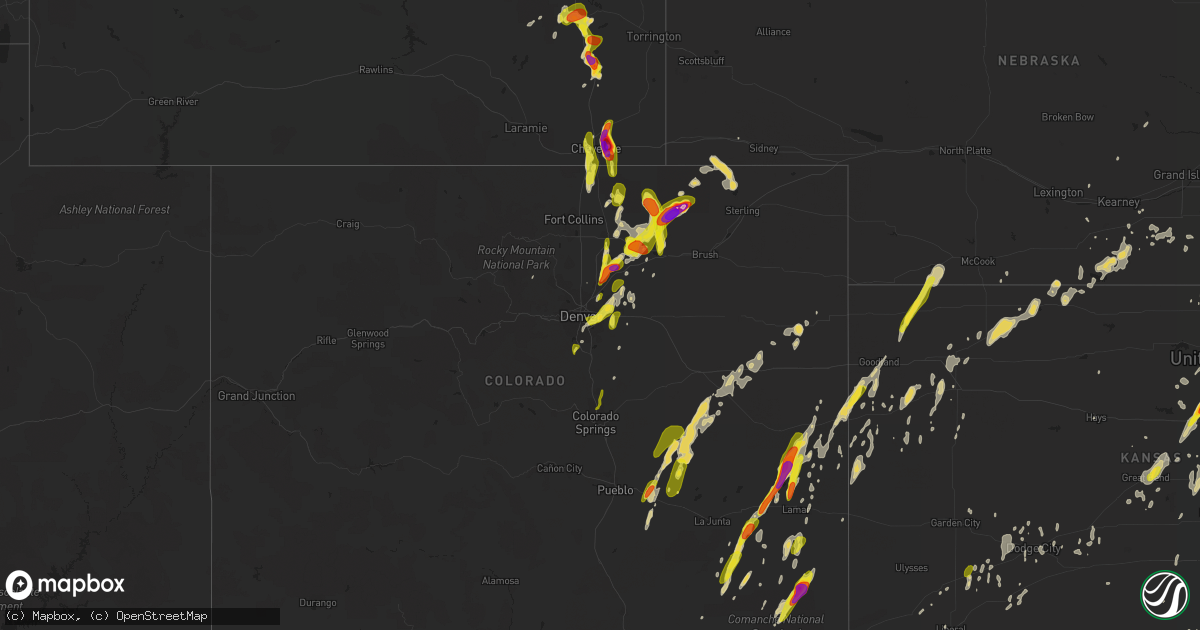
Hail Map on May 26, 2019
Get this storm
May 26 map
$229
one time, instant access
Download today. No call, no setup
Keep the $229
Bought the map and want the full workflow? Apply the entire $229 to a subscription within 7 days. None of it is wasted.
Every map, not just this one
This buys you this map. Subscription and you get every map we run, in the markets you choose from a few cities to whole states to nationwide. Plus real-time alerts the moment a storm fires.
Contact data
Name, contact info, occupancy, even credit band for addresses in the footprint. You go from where it hit to who to call.
Become the source they trust
Unlimited branding weather history reports on demand. You already have the documented answer ready for the property owner, and you are the one who showed up with it.
Property data and RoofTrace estimates
Pull up any address you have got, its value and the exact code rules for that jurisdiction, straight from One Click Code. Then RoofTrace estimates the squares, pitch, and roof value, priced the way you price.
States Impacted by Hail Map on May 26, 2019
Storm reports
Nebraska
| Date | Description |
|---|---|
| 05/26/20196:56 PM CDT | Heavy rainfall with it |
| 05/26/20195:45 PM CDT | Quarter sized hail with torrential rainfall |
| 05/26/20194:10 AM CDT | One carport lifted onto house... Another blown into the trees. 20 inch diameter tree snapped. Several trees uprooted. Time estimated by radar. |
| 05/26/20193:57 AM CDT | At 857 PM CDT, severe thunderstorms were located along a line extending from near Giltner to near Saronville to near Clay Center to Edgar, moving east at 30 mph. HAZARD...60 mph wind gusts. SOURCE...Radar indicated. IMPACT...Expect damage to roofs, siding, and trees. Locations impacted include... Geneva, Sutton, Harvard, Henderson, Clay Center, Fairmont, Edgar, McCool Junction, Fairfield, Giltner, Shickley, Grafton, Ong, Saronville, Stockham, Lushton and Strang.This includes Interstate 80 between mile markers 330 and 352. |
| 05/26/20193:52 AM CDT | At 852 PM CDT, a severe thunderstorm was located 12 miles northwest of Atwood, moving northeast at 45 mph. HAZARD...Half dollar size hail. SOURCE...Radar indicated. IMPACT...Damage to vehicles is expected. Locations impacted include... Trenton, Culbertson, Palisade and Stratton. |
| 05/26/20193:30 AM CDT | At 830 PM CDT, severe thunderstorms were located along a line extending from near Inland to near Glenvil to near Lawrence, moving east at 45 mph. HAZARD...60 mph wind gusts. SOURCE...Radar indicated. IMPACT...Expect damage to roofs, siding, and trees. Locations impacted include... Hastings, Sutton, Harvard, Henderson, Clay Center, Edgar, Fairfield, Shickley, Glenvil, Lawrence, Davenport, Grafton, Inland, Deweese, Ong, Saronville and Stockham. |
| 05/26/20193:00 AM CDT | Mesonet station cw6705 fairbury. |
| 05/26/20192:26 AM CDT | At 726 PM CDT, severe thunderstorms were located along a line extending from near Minden to near Upland to near Franklin, moving east at 50 mph. HAZARD...70 mph wind gusts. SOURCE...Radar indicated. IMPACT...Expect considerable tree damage. Damage is likely to mobile homes, roofs, and outbuildings. Locations impacted include... Blue Hill, Campbell, Bladen, Roseland, Holstein, Upland, Ayr, Norman, Cowles and Rosemont. |
| 05/26/20192:02 AM CDT | At 701 PM CDT, severe thunderstorms were located along a line extending from Wilcox to near Huntley to near Harlan County Dam, moving east at 35 mph. HAZARD...60 mph wind gusts. SOURCE...Radar indicated. IMPACT...Expect damage to roofs, siding, and trees. Locations impacted include... Franklin, Hildreth, Wilcox, Republican City, Upland, Naponee, Bloomington, Riverton, Huntley, Ragan and Harlan County Dam. |
| 05/26/20191:52 AM CDT | At 652 PM CDT, a severe thunderstorm was located 10 miles southeast of Springview, moving east at 20 mph. HAZARD...Half dollar size hail. SOURCE...Radar indicated. IMPACT...Damage to vehicles is expected. Locations impacted include... Brocksburg and Mariaville. This includes Highway 12 between mile markers 74 and 80. |
| 05/26/201912:13 AM CDT | Tree blown onto home. Power lines also blown down. |
| 05/25/201911:59 PM CDT | Hail damaged numerous car windows on interstate 76 from the colorado state line east to big springs. Several semi tractor trailers sustained broken windows at the big s |
| 05/25/201911:59 PM CDT | Reports of trees and power lines down in orchard. Started around 11:11pm cdt. |
| 05/25/201910:25 PM CDT | At 324 AM MDT, a severe thunderstorm was located 7 miles northwest of Oliver Campground, or 14 miles northwest of Kimball, moving northeast at 20 mph. This storm has had a history of producing lots of hail covering the ground. HAZARD...Quarter size hail. SOURCE...Radar indicated. IMPACT...Damage to vehicles is possible. Locations impacted include... Harrisburg and Bushnell. |
| 05/25/20199:43 PM CDT | At 240 AM MDT, a severe thunderstorm was located near Pine Bluffs, or 25 miles west of Kimball, moving northeast at 25 mph. This storm has a history of producing a large amount of hail as it moved northeast through the Burns area. HAZARD...Half dollar size hail. SOURCE...Radar indicated. IMPACT...Damage to vehicles is possible. Locations impacted include... Pine Bluffs, Albin, Oliver Campground and Bushnell. This includes the following highways... Interstate 80 in Wyoming between mile markers 393 and 402. Interstate 80 in Nebraska between mile markers 1 and 8. |
| 05/25/20197:21 PM CDT | Delayed report of brief ef-1 tornado 6 miles southwest of upland on sunday evening. Please refer to earlier-issued public info statement for further details. |
| 05/25/20197:20 PM CDT | Law enforcement and spotters reported one farmstead had outbuilding and power line damage. Another farmstead to its west had notable tree damage. There was also at leas |
Virginia
| Date | Description |
|---|---|
| 05/26/20194:50 PM CDT | Multiple trees down across the county. |
| 05/26/20194:20 PM CDT | Tree down on power lines on route 20 just north of keene. |
| 05/26/20194:15 PM CDT | Large branches down on rt. 20 just north of keene... Va. |
| 05/26/20193:58 PM CDT | Multiple trees and powerpoles knocked down across/along us-360 between sr-600 and sr-721. Time estimated from radar. |
| 05/26/20193:55 PM CDT | Tree downed onto power line on va-30 between mangohick and calno. |
| 05/26/20193:02 PM CDT | Reports relayed via social media of trees down along shannon hill road near i-64. |
| 05/26/20192:58 PM CDT | Multiple trees downed/uprooted. Time estimated from radar. |
| 05/26/20192:52 PM CDT | Power lines down along bull church rd near ladysmith. Time estimated via radar. |
| 05/26/20192:40 PM CDT | Tree down in the 10000 block of wallers road near partlow. |
| 05/26/20192:33 PM CDT | Tree down in the 5900 block of partlow road. |
| 05/26/20192:30 PM CDT | Three trees uprooted and three trees snapped. One tree fell on a home and another broke windows. All trees fell down in the same direction. |
| 05/26/20192:29 PM CDT | Trees down along evergreen rd. Time estimated via radar. |
| 05/26/20192:24 PM CDT | Trees down around zion crossroads with thunderstorm passage. Time estimated via radar data. |
| 05/26/20192:02 PM CDT | Tree down on louisa road near black cat road. |
| 05/26/20191:53 PM CDT | Tree down on the 3400 block of stony point road. |
| 05/26/20191:50 PM CDT | Tree down on the 2000 block of hawkshill lane. |
| 05/26/20191:46 PM CDT | Tree down on georgetown road near terrell road e. |
| 05/26/20191:35 PM CDT | Tree down on 3900 block of free union road. |
| 05/26/20197:46 AM CDT | At 1246 AM EDT, severe thunderstorms were located along a line extending from near Lunenburg to Rehoboth to Chase City, moving east at 35 mph. HAZARD...60 mph wind gusts and quarter size hail. SOURCE...Radar indicated. IMPACT...Minor damage to vehicles is possible. Expect wind damage to trees and powerlines. Severe thunderstorms will be near, Victoria and Lunenburg around 1255 AM EDT. Kenbridge around 100 AM EDT. Dundas around 115 AM EDT. South Hill and La Crosse around 120 AM EDT. Brodnax and Alberta around 125 AM EDT.Other locations impacted by these severe thunderstorms include BaconsFork, Cochran, Wilburn, Spanish Grove, Gills Corner, Arvins Store,Dolphin, Nutbush, Finneywood and Meredithville. |
| 05/26/20195:52 AM CDT | At 1051 PM EDT, a severe thunderstorm was located 7 miles southeast of Tangier, or 16 miles north of Exmore, moving east at 25 mph. HAZARD...60 mph wind gusts and quarter size hail. SOURCE...Radar indicated. IMPACT...Minor damage to vehicles is possible. Expect wind damage to trees and powerlines. This severe thunderstorm will be near, Onancock around 1105 PM EDT. Onley around 1110 PM EDT. Parksley around 1120 PM EDT.Other locations impacted by this severe thunderstorm includeTemperanceville, Nelsonia, Modest Town, Mappsville, Clam, Guilford,Bloxom, Assawoman, Tasley and Accomac. |
| 05/26/20194:40 AM CDT | At 939 PM EDT, severe thunderstorms were located along a line extending from near Flat Top to near Rocky Gap to near Atkins, moving east at 55 mph. HAZARD...60 mph wind gusts. SOURCE...Radar indicated. IMPACT...Expect damage to roofs, siding, and trees. Locations impacted include... Radford... Pulaski... Wytheville... Bland... and Princeton. |
| 05/26/20193:15 AM CDT | At 815 PM EDT, a severe thunderstorm was located over Culpeper, moving east at 15 mph. HAZARD...60 mph wind gusts and quarter size hail. SOURCE...Radar indicated. IMPACT...Damaging winds will cause some trees and large branches to fall. This could injure those outdoors, as well as damage homes and vehicles. Roadways may become blocked by downed trees. Localized power outages are possible. Unsecured light objects may become projectiles. Locations impacted include... Culpeper, Winston, Lignum, Elkwood, Catalpa, Stevensburg, Mitchells, Brandy Station and Richardsville. |
| 05/26/20192:32 AM CDT | At 731 PM EDT, a severe thunderstorm was located over Amburgey, or over Hindman, moving east at 45 mph. HAZARD...60 mph wind gusts. SOURCE...Radar indicated. IMPACT...Expect damage to roofs, siding, and trees. Locations impacted include... Hazard, Whitesburg, Hindman, Letcher, Bath, Jenkins, Elkhorn City, Wheelwright, Fleming-Neon, Pippa Passes, Vicco and Blackey. |
| 05/26/20191:38 AM CDT | At 638 PM EDT, a severe thunderstorm was located near Culpeper, moving east at 25 mph. HAZARD...60 mph wind gusts and quarter size hail. SOURCE...Radar indicated. IMPACT...Damaging winds will cause some trees and large branches to fall. This could injure those outdoors, as well as damage homes and vehicles. Roadways may become blocked by downed trees. Localized power outages are possible. Unsecured light objects may become projectiles. Locations impacted include... Culpeper, Warrenton, Bealeton, Opal, Remington, Catlett, Calverton, Midland, Elkwood, Catalpa, Brandy Station, Auburn, Lois, Casanova, Jeffersonton, Turnbull, Cardova, Rixeyville, Morrisville and Alanthus. |
| 05/26/201912:39 AM CDT | At 538 PM EDT, a severe thunderstorm was located near Palmyra, moving east at 25 mph. HAZARD...60 mph wind gusts and quarter size hail. SOURCE...Radar indicated. IMPACT...Minor damage to vehicles is possible. Expect wind damage to trees and powerlines. This severe thunderstorm will be near, Palmyra around 550 PM EDT. Fork Union around 555 PM EDT. Columbia and Kents Store around 605 PM EDT. Duncan around 610 PM EDT. Hadensville, Cartersville and Fife around 620 PM EDT.Other locations impacted by this severe thunderstorm include Dixie,Nahor, Stage Junction, Shores, Zion Crossroads, Central Plains, BremoBluff, Antioch, Tamworth and Union Mills. |
| 05/26/201912:33 AM CDT | At 533 PM EDT, a severe thunderstorm was located over Warrenton, moving east at 15 mph. HAZARD...60 mph wind gusts and quarter size hail. SOURCE...Radar indicated. IMPACT...Damaging winds will cause some trees and large branches to fall. This could injure those outdoors, as well as damage homes and vehicles. Roadways may become blocked by downed trees. Localized power outages are possible. Unsecured light objects may become projectiles. Locations impacted include... Warrenton, Bealeton, New Baltimore, Opal, Catlett, Calverton, Midland, Turnbull, Auburn and Casanova. |
| 05/26/201912:15 AM CDT | At 515 PM EDT, a severe thunderstorm was located 10 miles northeast of Schuyler, or 11 miles south of Charlottesville, moving east at 20 mph. HAZARD...60 mph wind gusts and quarter size hail. SOURCE...Radar indicated. IMPACT...Damaging winds will cause some trees and large branches to fall. This could injure those outdoors, as well as damage homes and vehicles. Roadways may become blocked by downed trees. Localized power outages are possible. Unsecured light objects may become projectiles. Locations impacted include... Scottsville, Esmont, Keene, Glendower, Overton, Alberene and Woodridge. |
| 05/26/201912:10 AM CDT | At 509 PM EDT, a severe thunderstorm was located near Stevensville, or near King William, moving southeast at 30 mph. HAZARD...60 mph wind gusts and quarter size hail. SOURCE...Radar indicated. IMPACT...Minor damage to vehicles is possible. Expect wind damage to trees and powerlines. Locations impacted include... King And Queen Court House, Stevensville, Jamaica, Little Plymouth, Laneview, Ino, Dragonville, Walkerton, Montague, Crouch, Henley Fork, Bruington and Velma. |
| 05/25/201911:35 PM CDT | At 435 PM EDT, a severe thunderstorm was located over Mangohick, or 10 miles west of Saint Stephens Church, moving southeast at 30 mph. HAZARD...60 mph wind gusts and quarter size hail. SOURCE...Radar indicated. IMPACT...Minor damage to vehicles is possible. Expect wind damage to trees and powerlines. This severe thunderstorm will be near, Beulahville and Newtown around 440 PM EDT. Saint Stephens Church, Aylett and Manquin around 455 PM EDT. King William around 510 PM EDT.Other locations impacted by this severe thunderstorm include Enfield,Central Garage, Owenton, Upshaw, Etna Mills, Walkerton, Epworth,Biscoe, Gether and Calno. |
| 05/25/201910:56 PM CDT | At 356 PM EDT, a severe thunderstorm was located near Hadensville, moving southeast at 20 mph. HAZARD...60 mph wind gusts and quarter size hail. SOURCE...Radar indicated. IMPACT...Minor damage to vehicles is possible. Expect wind damage to trees and powerlines. This severe thunderstorm will be near, Hadensville around 405 PM EDT. Fife around 410 PM EDT. Gum Spring around 425 PM EDT. Goochland around 440 PM EDT.Other locations impacted by this severe thunderstorm include Orchid,Sandy Hook, Rock Castle, Stage Junction, Three Square, Irwin,Caledonia, Dabneys, Yanceyville and Georges Tavern. |
| 05/25/201910:38 PM CDT | At 337 PM EDT, a severe thunderstorm was located near Ladysmith, or 13 miles west of Milford, moving southeast at 25 mph. HAZARD...60 mph wind gusts and quarter size hail. SOURCE...Radar indicated. IMPACT...Minor damage to vehicles is possible. Expect wind damage to trees and powerlines. Locations impacted include... Bowling Green, Milford, Ladysmith, Dawn, Fort A.p. Hill, Kings Dominion, Chilesburg, Rappahannock Academy, Sparta, Golansville, Villboro, Guinea, Corbin, Hewlett, Doswell, Penola, Noel, Burruss Corner, Nancy Wrights Corner and Cedar Fork. |
| 05/25/201910:21 PM CDT | At 321 PM EDT, a severe thunderstorm was located near Boswells Tavern, or 9 miles west of Louisa, moving southeast at 25 mph. HAZARD...60 mph wind gusts and quarter size hail. SOURCE...Radar indicated. IMPACT...Minor damage to vehicles is possible. Expect wind damage to trees and powerlines. This severe thunderstorm will be near, Ferncliff and Kents Store around 335 PM EDT. Louisa around 340 PM EDT. Mineral around 350 PM EDT. Hadensville around 355 PM EDT.Other locations impacted by this severe thunderstorm include Orchid,Pendleton, Louisa Airport, Green Springs, Zion Crossroads, Cuckoo,Bybee, Yanceyville, Fredericks Hall and Waldrop. |
| 05/25/201910:03 PM CDT | At 303 PM EDT, a severe thunderstorm was located 12 miles east of Orange, moving southeast at 25 mph. HAZARD...60 mph wind gusts and quarter size hail. SOURCE...Radar indicated. IMPACT...Damaging winds will cause some trees and large branches to fall. This could injure those outdoors, as well as damage homes and vehicles. Roadways may become blocked by downed trees. Localized power outages are possible. Unsecured light objects may become projectiles. Locations impacted include... Massaponax, Spotsylvania, Mine Run, Brokenburg, Parker, Verdiersville, Locust Grove, Snell, Alsop, Gold Dale, Gatewood, Thornhill, Logan, Partlow, Lahore, Glenora, Post Oak and Thornburg. |
| 05/25/20199:57 PM CDT | At 257 PM EDT, a severe thunderstorm was located 9 miles northwest of Boswells Tavern, or 10 miles northeast of Charlottesville, moving southeast at 25 mph. HAZARD...60 mph wind gusts and quarter size hail. SOURCE...Radar indicated. IMPACT...Damaging winds will cause some trees and large branches to fall. This could injure those outdoors, as well as damage homes and vehicles. Roadways may become blocked by downed trees. Localized power outages are possible. Unsecured light objects may become projectiles. Locations impacted include... Campbell, Westmoreland, Hollymead, Cobham, Cismont, Boyd Tavern, Keswick and Stony Point. |
| 05/25/20199:45 PM CDT | At 245 PM EDT, a severe thunderstorm was located 7 miles east of Free Union, or 8 miles northeast of Charlottesville, moving southeast at 30 mph. HAZARD...60 mph wind gusts and quarter size hail. SOURCE...Radar indicated. IMPACT...Damaging winds will cause some trees and large branches to fall. This could injure those outdoors, as well as damage homes and vehicles. Roadways may become blocked by downed trees. Localized power outages are possible. Unsecured light objects may become projectiles. Locations impacted include... Campbell, Westmoreland, Hollymead, Cobham, Cismont, Boyd Tavern, Keswick, Stony Point, Advance Mills, Carrsbrook and Earlysville. |
| 05/25/20199:35 PM CDT | Large oak tree down across pearman road in preston forest subdivision on brush mountain north of blacksburg. Location approximately 1 mile from intersection with coal b |
| 05/25/20199:22 PM CDT | Trees down for about a mile along freestone valley rd near the smyth and tazewell county line. |
| 05/25/20199:17 PM CDT | 3 trees down on mountain lake road. Time from radar. |
| 05/25/20199:12 PM CDT | Tree down on route 644 at newbern road. Time from radar. |
| 05/25/20198:50 PM CDT | Tree down near the intersection of wilderness rd and rt 42. Time estimated by radar. |
| 05/25/20198:47 PM CDT | Powerlines down on skydusky rd. Time estimated by radar. |
| 05/25/20198:38 PM CDT | Tree down on grapefield rd. Time estimated by radar. |
| 05/25/20198:36 PM CDT | One tree down. Time from radar. |
| 05/25/20198:32 PM CDT | Multiple trees down. |
| 05/25/20198:29 PM CDT | Tree down. |
| 05/25/20198:25 PM CDT | Trees and limbs down. Time from radar. |
| 05/25/20198:24 PM CDT | Tree down. |
| 05/25/20198:22 PM CDT | Tree down. Time from radar. |
| 05/25/20198:22 PM CDT | Multiple trees down. Time from radar. |
| 05/25/20198:20 PM CDT | Tree down. Time from radar. |
| 05/25/20198:18 PM CDT | Trees down. |
| 05/25/20198:18 PM CDT | Corrects previous tstm wnd dmg report from 4 wsw asberrys. Trees down for about a mile along freestone valley rd near the smyth and tazewell county line. Time estimated |
| 05/25/20198:17 PM CDT | Multiple trees down. |
| 05/25/20198:17 PM CDT | Multiple trees down. Time from radar. |
| 05/25/20198:15 PM CDT | Tree down. |
| 05/25/20198:15 PM CDT | Tree down. Time from radar. |
| 05/25/20198:06 PM CDT | Trees down. |
| 05/25/20198:06 PM CDT | Tree down. |
| 05/25/20198:03 PM CDT | Corrects previous tstm wnd dmg report from 2 s bandy. Tree down. Time from radar. |
| 05/25/20198:02 PM CDT | Corrects previous tstm wnd dmg report from 1 e cedar bluff. Tree down. Time from radar. |
| 05/25/20198:00 PM CDT | Tree down. Time from radar. |
| 05/25/20198:00 PM CDT | Corrects previous tstm wnd dmg report from 1 se raven. Large tree down. Time from radar. |
| 05/25/20198:00 PM CDT | Large tree down blocking both lanes of u.s. Route 460 west. |
| 05/25/20197:56 PM CDT | Corrects previous tstm wnd dmg report from 2 n raven. Large tree down blocking both lanes of u.s. Route 460 west. |
| 05/25/20197:50 PM CDT | Power outage due to tree out of row. Via outage map... Time estimated via radar. |
| 05/25/20197:40 PM CDT | Power outage due to tree damage. Via outage map... Time based on outage time and radar. |
| 05/25/20197:25 PM CDT | Numerous tree limbs and small trees down between grundy and the state border with ky. Time estimated via radar. |
| 05/25/20197:20 PM CDT | Power outage due to tree out of row. Via outage map... Time estimated via radar. |
| 05/25/20197:13 PM CDT | Power outage due to tree out of row. Via outage map... Time estimated via radar. |
Indiana
| Date | Description |
|---|---|
| 05/26/20193:07 PM CDT | Large tree branch down. Time estimated from radar data. |
| 05/25/201911:51 PM CDT | At 450 AM EDT, severe thunderstorms were located along a line extending from near Wabash to near La Fontaine to near Windfall City, moving east at 60 mph. HAZARD...60 mph wind gusts. SOURCE...Radar indicated. IMPACT...Expect damage to roofs, siding, and trees. Locations impacted include... Marion, Wabash, Gas City, Upland, Fairmount, Jonesboro, Sweetser, Swayzee, La Fontaine, Van Buren, Matthews, Sims, Converse, Lancaster, Fowlerton, Mount Etna, Landess, Mier, Herbst and Majenica.At 443 AM EDT, a gust to 66 mph was measured at Kokomo.This includes Interstate 69 in Indiana between mile markers 252 and278. |
| 05/25/201911:34 PM CDT | At 433 AM EDT, severe thunderstorms were located along a line extending from 6 miles east of Logansport to near Walton to 6 miles northwest of Kokomo, moving east at 35 mph. The Cass County Airport in Logansport recorded a 52 mph wind gust with this line of storms. HAZARD...60 mph wind gusts and penny size hail. SOURCE...Radar indicated. IMPACT...Expect damage to roofs, siding, and trees. Locations impacted include... Peru, Grissom Afb, Walton, Bunker Hill, Lincoln, Wells, Galveston, Miami, Converse, Amboy, Onward, Bennetts Switch, Santa Fe, Wawpecong, Peoria and Nead. |
| 05/25/201911:09 PM CDT | At 406 AM EDT, severe thunderstorms were located along a line extending from 8 miles southeast of Delphi to near Frankfort to 8 miles east of Rockville, moving east at 45 mph. HAZARD...60 mph wind gusts and nickel size hail. SOURCE...Radar indicated. IMPACT...Expect damage to roofs, siding, and trees. Locations impacted include... Kokomo, Frankfort, Brownsburg, Lebanon, Zionsville, Danville, Tipton, Windfall, Westfield, Pittsboro, Whitestown, Sheridan, Greentown, Flora, Rossville, Thorntown, Russiaville, Ladoga, Jamestown and Roachdale.This includes the following highways... Interstate 65 between mile markers 128 and 155. Interstate 74 between mile markers 41 and 67. |
| 05/25/201911:07 PM CDT | At 407 PM EDT, a severe thunderstorm was located near Rising Sun, moving east at 40 mph. HAZARD...60 mph wind gusts and quarter size hail. SOURCE...Radar indicated. IMPACT...Minor hail damage to vehicles is possible. Expect wind damage to trees and power lines. Locations impacted include... Cincinnati, Florence, Erlanger, Elsmere, Cheviot, Villa Hills, Lawrenceburg, Greendale, Aurora, Walton, Rising Sun, Oakbrook, Burlington, Union, Shawnee, Delhi Township, Delhi Hills, Bridgetown, Mack and Wilmington.This includes the following Interstates... I-71 in Kentucky between mile markers 71 and 77. I-75 in Kentucky between mile markers 170 and 183. |
| 05/25/201910:46 PM CDT | At 346 AM EDT, a severe thunderstorm was located near Rockville, or 23 miles southwest of Crawfordsville, moving east at 50 mph. HAZARD...60 mph wind gusts and nickel size hail. SOURCE...Radar indicated. IMPACT...Expect damage to roofs, siding, and trees. Locations impacted include... Rockville, Newport, Montezuma, Ladoga, Roachdale, Bainbridge, New Market, Waveland, Russellville, New Ross, Mecca, Bloomingdale, Marshall, Carpentersville, Cecil Harden Lake, Lodi, Groveland, Turkey Run State Park, Shades State Park and Judson. |
| 05/25/201910:35 PM CDT | At 331 AM EDT, severe thunderstorms were located along a line extending from near Otterbein to 6 miles east of Veedersburg to near Newport, moving east at 50 mph. HAZARD...60 mph wind gusts and nickel size hail. SOURCE...Radar indicated. IMPACT...Expect damage to roofs, siding, and trees. Locations impacted include... Lafayette, Frankfort, Crawfordsville, West Lafayette, Delphi, Rossville, Shadeland, Thorntown, Dayton, Battle Ground, Mulberry, Waynetown, Darlington, Linden, Colfax, Clarks Hill, New Ross, New Richmond, Wingate and Alamo.This includes the following highways... Interstate 65 between mile markers 148 and 184. Interstate 74 between mile markers 24 and 48. |
| 05/25/20199:29 PM CDT | At 228 PM CDT, a severe thunderstorm was located over Melody Hill, moving east at 45 mph. HAZARD...60 mph wind gusts and penny size hail. SOURCE...Radar indicated. IMPACT...Expect damage to roofs, siding, and trees. Locations impacted include... Evansville, Boonville, Chandler, Melody Hill, Darmstadt and Elberfeld. |
| 05/25/20198:45 PM CDT | At 145 AM CDT/245 AM EDT/, severe thunderstorms were located along a line extending from Claytonville to near Rankin, moving east at 45 mph. HAZARD...60 mph wind gusts. SOURCE...Radar indicated. IMPACT...Expect damage to roofs, siding, and trees. Severe thunderstorms will be near, Milford around 155 AM CDT. Stockland around 205 AM CDT. Freeland Park and Dunnington around 310 AM EDT. Talbot around 315 AM EDT. Boswell around 320 AM EDT. Fowler and Barce around 325 AM EDT. Templeton, Lochiel, Wadena, Atkinson and Oxford around 330 AM EDT. Foresman around 335 AM EDT.Other locations impacted by these severe thunderstorms include Ambiaand Wellington. |
Montana
| Date | Description |
|---|---|
| 05/26/20195:31 PM CDT | A local report indicates 1.50 inch wind near RAPELJE |
| 05/26/20195:30 PM CDT | Dime to ping pong ball size hail. |
| 05/26/20194:51 PM CDT | A local report indicates 2.00 inch wind near ALZADA |
| 05/26/20194:41 PM CDT | A local report indicates 1.00 inch wind near 7 ESE LIVINGSTON |
| 05/26/20194:26 AM CDT | At 925 PM MDT, a severe thunderstorm was located 16 miles east of Roundup, moving southeast at 10 mph. HAZARD...Half dollar size hail and torrential rain. SOURCE...Radar indicated. IMPACT...Damage to vehicles is expected. Rapid rises on creeks and streams could cause water to cross roads. This severe thunderstorm will remain over mainly rural areas of southeastern Musselshell County. |
| 05/26/20194:15 AM CDT | At 914 PM MDT, a severe thunderstorm was located near Shepherd, or 11 miles north of Billings, moving southeast at 15 mph. HAZARD...Ping pong ball size hail and 60 mph wind gusts, along with very heavy rainfall. Localized flash flooding is possible. SOURCE...Spotters indicated. IMPACT...People and animals outdoors will be injured. Expect hail damage to roofs, siding, windows, and vehicles. Expect wind damage to roofs, siding, and trees. Locations impacted include... Shepherd, Huntley, Worden and Ballantine. This warning does not include the city of Billings. |
| 05/26/20192:52 AM CDT | At 751 PM MDT, a severe thunderstorm was located 16 miles northwest of Billings Heights, or 19 miles northwest of Billings, moving east at 10 mph. HAZARD...Quarter size hail. SOURCE...Radar indicated. IMPACT...Damage to vehicles is expected. Locations impacted include... Shepherd, Broadview, Acton and Comanche. This warning does not include the city of Billings.This replaces the warning previously in effect for this area. |
| 05/26/20192:04 AM CDT | At 700 PM MDT, a cluster of severe thunderstorms extending from Broadview southwestward toward Rapelje, or approximately 25 miles northwest of Billings, and is nearly stationary. HAZARD...Quarter size hail. IMPACT...Damage to vehicles is expected. Locations impacted include... Broadview, Halfbreed Lake Wildlife, Hailstone Wildlife Refuge, Rapelje, Molt and Comanche.This warning does not include the city of Billings. |
| 05/26/20191:10 AM CDT | At 609 PM MDT, a severe thunderstorm was located 21 miles west of Ridgeway, or 23 miles east of Broadus, moving north at 20 mph. HAZARD...Ping pong ball size hail and 60 mph wind gusts, along with heavy rain and frequent lightning. SOURCE...Radar indicated. IMPACT...People and animals outdoors will be injured. Expect hail damage to roofs, siding, windows, and vehicles. Expect wind damage to roofs, siding, and trees. This severe thunderstorm will remain over mainly rural areas of southwestern Carter and northeastern Powder River Counties, to the north of Highway 212. |
| 05/25/201911:37 PM CDT | At 436 PM MDT, a severe thunderstorm was located near Alzada, or 40 miles northwest of Belle Fourche, moving north at 25 mph. This storm will cross Highway 212 near and west of Alzada. HAZARD...Ping pong ball size hail and 60 mph wind gusts, along with heavy rain and frequent lightning. SOURCE...Radar indicated. IMPACT...People and animals outdoors will be injured. Expect hail damage to roofs, siding, windows, and vehicles. Expect wind damage to roofs, siding, and trees. Locations impacted include... Alzada. |
| 05/25/201911:31 PM CDT | At 430 PM MDT, a severe thunderstorm was located 3 miles northwest of Recluse, or 37 miles north of Gillette, moving northeast at 30 mph. HAZARD...Ping pong ball size hail. SOURCE...Radar indicated. IMPACT...People and animals outdoors will be injured. Expect damage to roofs, siding, windows, and vehicles. Locations impacted include... Spotted Horse and Recluse. |
| 05/25/201911:23 PM CDT | At 420 PM MDT, a severe thunderstorm was located 18 miles south of Ryegate, or 27 miles north of Columbus, moving north at 25 mph. HAZARD...60 mph wind gusts, quarter size hail and torrential rainfall. IMPACT...Hail damage to vehicles is expected. Expect wind damage to roofs, siding, and trees. Locations impacted include... Ryegate, Halfbreed Lake Wildlife, Hailstone Wildlife Refuge and Rapelje. |
| 05/25/201911:12 PM CDT | At 410 PM MDT, a severe thunderstorm was located 12 miles northeast of Alzada, or 38 miles northwest of Belle Fourche, moving north at 25 mph. HAZARD...60 mph wind gusts and quarter size hail, along with heavy rain and frequent lightning. SOURCE...Radar indicated. IMPACT...Hail damage to vehicles is expected. Expect wind damage to roofs, siding, and trees. Locations impacted include... Albion.This replaces the warning previously in effect for southeastern Carter County. |
| 05/25/201911:09 PM CDT | At 408 PM MDT, a severe thunderstorm was located 10 miles southeast of Absarokee, or 14 miles north of Red Lodge, moving northeast at 15 mph toward Cooney Reservoir State Park. HAZARD...60 mph wind gusts and quarter size hail. IMPACT...Hail damage to vehicles is expected. Expect wind damage to roofs, siding, and trees. Locations impacted include... Joliet, Cooney Reservoir State Park, Roberts, Rockvale, Boyd and Silesia. |
| 05/25/201910:31 PM CDT | At 331 PM MDT, a severe thunderstorm was located 7 miles southeast of Alzada, or 29 miles northwest of Belle Fourche, moving north at 30 mph. HAZARD...Golf ball size hail and 60 mph wind gusts, along with heavy rainfall. SOURCE...Radar indicated. IMPACT...People and animals outdoors will be injured. Expect hail damage to roofs, siding, windows, and vehicles. Expect wind damage to roofs, siding, and trees. Locations impacted include... Alzada, Capitol and Albion. |
| 05/25/201910:16 PM CDT | A local report indicates 1.75 inch wind near 9 N BILLINGS |
| 05/25/201910:12 PM CDT | Occuring at time of report |
| 05/25/201910:10 PM CDT | A few quarter but mostly smaller |
| 05/25/201910:08 PM CDT | A local report indicates 1.75 inch wind near 8 NNE BILLINGS |
| 05/25/20197:31 PM CDT | A local report indicates 1.50 inch wind near RAPELJE |
New Mexico
| Date | Description |
|---|---|
| 05/26/20196:54 PM CDT | Ktcc asos. |
| 05/26/20196:52 PM CDT | A local report indicates 60 MPH wind near 2 NNW MELROSE |
| 05/26/20196:52 PM CDT | Ktcc asos. |
| 05/26/20196:48 PM CDT | A local report indicates 1.00 inch wind near 10 WSW SENECA |
| 05/26/20196:45 PM CDT | Residents and utility workers report 2 transmission lines down north of ft sumner in de baca county. Power went out in ft. Sumner at 5...45pm. |
| 05/26/20196:45 PM CDT | Residents and utility workers report 2 transmission lines down north of ft sumner in de baca county. Power went out in ft. Sumner at 5...45pm. |
| 05/26/20196:30 PM CDT | Roof blown off a barn along sr-278 |
| 05/26/20196:27 PM CDT | A local report indicates 3.00 inch wind near 11 SSE MOUNT DORA |
| 05/26/20196:25 PM CDT | A local report indicates 3.00 inch wind near 12 WSW CLAYTON |
| 05/26/20196:25 PM CDT | A local report indicates a tornado near 1 W CLAYTON |
| 05/26/20196:23 PM CDT | A local report indicates 3.00 inch wind near 11 SE MOUNT DORA |
| 05/26/20196:23 PM CDT | A local report indicates 3.00 inch wind near 11 SE DORA |
| 05/26/20196:22 PM CDT | A local report indicates 2.50 inch wind near 12 S MOUNT DORA |
| 05/26/20196:22 PM CDT | A local report indicates 2.50 inch wind near 12 S DORA |
| 05/26/20196:22 PM CDT | A local report indicates 2.50 inch wind near 12 S MOUNT DORA |
| 05/26/20196:20 PM CDT | A local report indicates a tornado near CLAYTON |
| 05/26/20196:15 PM CDT | A local report indicates 3.00 inch wind near 11 SE MOUNT DORA |
| 05/26/20196:10 PM CDT | A local report indicates 1.50 inch wind near 11 SSE MOUNT DORA |
| 05/26/20196:05 PM CDT | A local report indicates a tornado near 14 S MOUNT DORA |
| 05/26/20196:02 PM CDT | Video via twitter. |
| 05/26/20195:55 PM CDT | A local report indicates a tornado near 8 WSW CLAYTON |
| 05/26/20195:55 PM CDT | Minor damage to rooftops on barns and residences |
| 05/26/20195:00 PM CDT | Large barn destroyed by outflow winds |
| 05/26/20194:45 PM CDT | Large branch down on silver and 12th |
| 05/26/20194:40 PM CDT | Kabq asos. |
| 05/26/20194:25 PM CDT | A local report indicates 60 MPH wind near LOS LUNAS |
| 05/26/20194:15 PM CDT | Cerro colorado landfill |
| 05/26/20197:13 AM CDT | At 1213 PM MDT, a severe thunderstorm was located near Kenton, or 31 miles northwest of Boise City, moving northeast at 50 mph. HAZARD...60 mph wind gusts and half dollar size hail. SOURCE...Radar indicated. IMPACT...Hail damage to vehicles is expected. Expect wind damage to roofs, siding, and trees. Locations impacted include... Campo. |
| 05/26/20196:55 AM CDT | At 1155 AM MDT, a severe thunderstorm was located 10 miles southwest of Kenton, or 24 miles north of Clayton, moving northeast at 55 mph. HAZARD...60 mph wind gusts and half dollar size hail. SOURCE...Radar indicated. IMPACT...Hail damage to vehicles is expected. Expect wind damage to roofs, siding, and trees. Locations impacted include... Moses. |
| 05/26/20192:37 AM CDT | At 736 PM CDT, severe thunderstorms were located along a line extending from 10 miles south of Glenrio to 10 miles southeast of Elida, moving east at 35 mph. HAZARD...60 mph wind gusts and quarter size hail. SOURCE...Radar indicated. IMPACT...Hail damage to vehicles is expected. Expect wind damage to roofs, siding, and trees. Locations impacted include... Muleshoe, Friona, Bovina, Farwell, Summerfield, Needmore, Lazbuddie, Progress, Oklahoma Lane, Lariat, West Camp, Black, Rhea and Maple. |
| 05/26/20191:28 AM CDT | At 627 PM MDT, severe thunderstorms were located along a line extending from 9 miles west of Romero to 11 miles northeast of Logan, moving east at 30 mph. These are very dangerous storms. HAZARD...Three inch hail. SOURCE...Radar indicated. IMPACT...People and animals outdoors will be severely injured. Expect shattered windows, extensive damage to roofs, siding, and vehicles. Locations impacted include... Nara Visa and US Highway 54 |
| 05/26/201912:24 AM CDT | At 524 PM MDT, a severe thunderstorm was located 15 miles west of Elkins, or 26 miles northeast of Roswell, moving northeast at 45 mph. HAZARD...70 mph wind gusts and ping pong ball size hail. SOURCE...Radar indicated. IMPACT...People and animals outdoors will be injured. Expect hail damage to roofs, siding, windows, and vehicles. Expect considerable tree damage. Wind damage is also likely to mobile homes, roofs, and outbuildings. This severe thunderstorm will remain over mainly rural areas of southeastern De Baca and north central Chaves Counties. |
| 05/26/201912:22 AM CDT | At 522 PM MDT, a severe thunderstorm was located 15 miles northeast of Bottomless Lakes State Park, or 25 miles east of Roswell, moving northeast at 30 mph. HAZARD...60 mph wind gusts and half dollar size hail. SOURCE...Radar indicated. IMPACT...Hail damage to vehicles is expected. Expect wind damage to roofs, siding, and trees. Locations impacted include... Elkins. |
| 05/26/201912:09 AM CDT | At 508 PM MDT, a severe thunderstorm was located near Bueyeros, or 25 miles west of Amistad, moving northeast at 30 mph. HAZARD...70 mph wind gusts and quarter size hail. SOURCE...Radar indicated. IMPACT...Hail damage to vehicles is expected. Expect considerable tree damage. Wind damage is also likely to mobile homes, roofs, and outbuildings. Locations impacted include... Bueyeros. |
| 05/25/201911:53 PM CDT | At 453 PM MDT, severe thunderstorms were located along a line extending from 17 miles southeast of Mosquero to 11 miles south of Montoya, moving northeast at 40 mph. HAZARD...70 mph wind gusts and quarter size hail. SOURCE...Radar indicated. IMPACT...Hail damage to vehicles is expected. Expect considerable tree damage. Wind damage is also likely to mobile homes, roofs, and outbuildings. Locations impacted include... Tucumcari and Montoya. This includes Interstate 40 between Mile Markers 309 and 343. |
| 05/25/201911:46 PM CDT | At 445 PM MDT, a severe thunderstorm was located 13 miles east of Chicosa Lake State Park, or 21 miles north of Mosquero, moving north at 30 mph. HAZARD...60 mph wind gusts and quarter size hail. SOURCE...Radar indicated. IMPACT...Hail damage to vehicles is expected. Expect wind damage to roofs, siding, and trees. Locations impacted include... Gladstone, Yatyes, US Highway 56, and NM Highway 453. |
| 05/25/201911:35 PM CDT | At 435 PM MDT, a severe thunderstorm was located over Santa Rosa, moving northeast at 30 mph. HAZARD...60 mph wind gusts and half dollar size hail. SOURCE...Radar indicated. IMPACT...Hail damage to vehicles is expected. Expect wind damage to roofs, siding, and trees. Locations impacted include... Santa Rosa, Santa Rosa Lake State Park and Colonias. This includes Interstate 40 between Mile Markers 265 and 289. |
| 05/25/201911:26 PM CDT | At 425 PM MDT, a severe thunderstorm was located over Mosquero, moving northeast at 40 mph. HAZARD...60 mph wind gusts and half dollar size hail. SOURCE...Radar indicated. IMPACT...Hail damage to vehicles is expected. Expect wind damage to roofs, siding, and trees. Locations impacted include... Mosquero and Solano. |
| 05/25/201911:14 PM CDT | At 412 PM MDT, a severe thunderstorm was located 8 miles northwest of Bueyeros, or 23 miles northeast of Mosquero, moving north at 20 mph. HAZARD...60 mph wind gusts and quarter size hail. SOURCE...Radar indicated. IMPACT...Hail damage to vehicles is expected. Expect wind damage to roofs, siding, and trees. This severe thunderstorm will remain over mainly rural areas of north central Harding and west central Union Counties including US Highway 56 and NM Highway 453. |
| 05/25/201910:40 PM CDT | At 340 PM MDT, a severe thunderstorm was located near South Valley, or near Albuquerque, moving northeast at 45 mph. HAZARD...60 mph wind gusts. SOURCE...Radar indicated. IMPACT...Expect damage to roofs, siding, and trees. Locations impacted include... Albuquerque, Los Ranchos De Albuquerque, Tijeras, South Valley, North Valley, Alameda, Carnuel and Cedar Crest.This includes the following highways... Interstate 40 between Mile Markers 157 and 174. Interstate 25 between Mile Markers 216 and 235. |
| 05/25/20198:55 PM CDT | A local report indicates a tornado near 8 NNE CAUSEY |
| 05/25/20198:49 PM CDT | A local report indicates a tornado near 4 ESE ROGERS |
| 05/25/20198:40 PM CDT | A local report indicates a tornado near 5 E DORA |
| 05/25/20198:36 PM CDT | Reported via twitter. |
| 05/25/20197:25 PM CDT | A local report indicates a tornado near 1 SW PEP |
| 05/25/20197:15 PM CDT | A local report indicates 1.00 inch wind near 1 SW WHEATLAND |
| 05/25/20197:04 PM CDT | Photo via twitter. |
| 05/25/20197:04 PM CDT | A local report indicates 58 MPH wind near LOGAN |
Colorado
| Date | Description |
|---|---|
| 05/26/20196:38 PM CDT | Brief touchdown... Then became quickly rain wrapped and not visible. No damage reported. |
| 05/26/20196:37 PM CDT | Brief touchdown approximately 1 mile south of front range airport. No damage reported. |
| 05/26/20196:32 PM CDT | On ground for an estimated 5 minutes in open field. |
| 05/26/20196:10 PM CDT | A local report indicates 1.00 inch wind near 3 W AURORA |
| 05/26/20196:05 PM CDT | A local report indicates 1.00 inch wind near 3 NNE CHERRY HILLS VILL |
| 05/26/20195:53 PM CDT | Corrects previous tornado report from 6 nw roggen. Brief touchdown... Then became quickly rain wrapped and not visible. No damage reported. |
| 05/26/20195:38 PM CDT | Brief touchdown in open field. No damage reported. |
| 05/26/20195:33 PM CDT | A local report indicates 1.00 inch wind near EVANS |
| 05/26/20195:32 PM CDT | A local report indicates 60 MPH wind near 3 WNW KEENESBURG |
| 05/26/20195:27 PM CDT | A local report indicates 1.50 inch wind near 5 SSE MILTON RESERVOIR |
| 05/26/20195:23 PM CDT | . |
| 05/26/20195:20 PM CDT | A local report indicates 1.25 inch wind near 4 S BARR LAKE |
| 05/26/20195:13 PM CDT | A local report indicates 1.25 inch wind near 4 N HUDSON |
| 05/26/20195:12 PM CDT | . |
| 05/26/20195:10 PM CDT | On the ground about 1 minute. |
| 05/26/20195:05 PM CDT | . |
| 05/26/20195:03 PM CDT | . |
| 05/26/20195:00 PM CDT | . |
| 05/26/20195:00 PM CDT | A local report indicates 1.25 inch wind near ORCHARD |
| 05/26/20194:53 PM CDT | A local report indicates 61 MPH wind near CORTEZ-MONTEZUMA AIRPOR |
| 05/26/20194:33 PM CDT | . |
| 05/26/20194:25 PM CDT | . |
| 05/26/20194:17 PM CDT | . |
| 05/26/20194:15 PM CDT | . |
| 05/26/20194:15 PM CDT | . |
| 05/26/20194:10 PM CDT | . |
| 05/26/20193:54 PM CDT | Tornado sighted 6 miles south of spotters position. On the ground about 1 minute. |
| 05/26/20193:38 PM CDT | Corrects previous tornado report from 3 ne lamar. Reports of same tornado also received from prowers county sheriff dispatch and trained spotter. |
| 05/26/20193:08 PM CDT | . |
| 05/26/20192:22 PM CDT | . |
| 05/26/20192:13 PM CDT | . |
| 05/26/20192:10 PM CDT | . |
| 05/26/20192:08 PM CDT | . |
| 05/26/20192:07 PM CDT | . |
| 05/26/20192:01 PM CDT | . |
| 05/26/20191:59 PM CDT | . |
| 05/26/20191:55 PM CDT | . |
| 05/26/201912:53 PM CDT | A local report indicates 60 MPH wind near MONTROSE REGIONAL AIRPO |
| 05/26/20197:43 AM CDT | At 1243 PM MDT, a severe thunderstorm was located 10 miles south of Springfield, moving northeast at 45 mph. HAZARD...60 mph wind gusts and half dollar size hail. SOURCE...Radar indicated. IMPACT...Hail damage to vehicles is expected. Expect wind damage to roofs, siding, and trees. Locations impacted include... Springfield, Walsh, Pritchett, Vilas, Two Buttes and Two Buttes Reservoir. |
| 05/26/20192:05 AM CDT | At 705 PM CDT, a severe thunderstorm was located over Seneca, or 13 miles north of Clayton, moving northeast at 55 mph. HAZARD...Ping pong ball size hail and 60 mph wind gusts. SOURCE...Radar indicated. IMPACT...Minor damage to roofs, siding, and trees is possible. People and animals outdoors will be injured. Expect hail damage to roofs, siding, windows, and vehicles. Locations impacted include... Boise City, Keyes, Kenton, Wheeless, Black Mesa Park, Felt and Sturgis. |
| 05/26/20191:59 AM CDT | At 658 PM MDT, a severe thunderstorm was located 6 miles northwest of Seibert, moving east at 50 mph. HAZARD...60 mph wind gusts and nickel size hail. SOURCE...Radar indicated. IMPACT...Expect damage to roofs, siding, and trees. Locations impacted include... Stratton, Seibert, Bonny Reservoir, Bethune, Vona, Joes and Hale. This includes the following highways... Interstate 70 in Colorado between mile markers 397 and 428. Highway 385 between mile markers 190 and 223. |
| 05/26/20191:41 AM CDT | At 641 PM MDT, a severe thunderstorm was located 5 miles north of New Raymer, or 29 miles north of Fort Morgan, moving northeast at 30 mph. HAZARD...Tennis ball size hail and 60 mph wind gusts. SOURCE...Radar indicated. IMPACT...Expect damage to roofs, siding, and trees. People and animals outdoors will be injured. Expect hail damage to roofs, siding, windows, and vehicles. Locations impacted include... New Raymer and Pawnee Buttes. |
| 05/26/20191:14 AM CDT | At 614 PM MDT, a severe thunderstorm was located 11 miles south of Burlington, moving northeast at 30 mph. HAZARD...60 mph wind gusts and quarter size hail. SOURCE...Radar indicated. IMPACT...Hail damage to vehicles is expected. Expect wind damage to roofs, siding, and trees. Locations impacted include... Burlington.This includes the following highways... Interstate 70 in Colorado between mile markers 430 and 450. Highway 385 between mile markers 171 and 206, and near mile marker211. |
| 05/26/20191:12 AM CDT | At 612 PM MDT, a severe thunderstorm was located 8 miles northwest of Two Buttes Reservoir, or 23 miles north of Springfield, moving north at 35 mph. HAZARD...60 mph wind gusts and quarter size hail. SOURCE...Radar indicated. IMPACT...Hail damage to vehicles is expected. Expect wind damage to roofs, siding, and trees. This severe thunderstorm will remain over mainly rural areas of southwestern Prowers County. |
| 05/26/201912:56 AM CDT | At 556 PM MDT, a severe thunderstorm was located near Natural Fort, or 11 miles south of Cheyenne, moving north at 15 mph. HAZARD...Ping pong ball size hail and 60 mph wind gusts. SOURCE...Radar indicated. IMPACT...People and animals outdoors will be injured. Expect hail damage to roofs, siding, windows, and vehicles. Expect wind damage to roofs, siding, and trees. Locations impacted include... Cheyenne, South Greeley, Warren AFB, Frontier Park, Warren Af Base, Ranchettes, Fox Farm-College and South Greeley High.This includes the following highways... Interstate 25 in Wyoming between mile markers 1 and 14. Interstate 80 in Wyoming between mile markers 351 and 368. |
| 05/26/201912:25 AM CDT | At 525 PM MDT, a severe thunderstorm was located 4 miles southwest of Cheyenne Wells, moving northeast at 30 mph. HAZARD...60 mph wind gusts and quarter size hail. SOURCE...Radar indicated. IMPACT...Hail damage to vehicles is expected. Expect wind damage to roofs, siding, and trees. Locations impacted include... Cheyenne Wells, Arapahoe and Firstview. This includes Highway 385 between mile markers 139 and 168. |
| 05/26/201912:23 AM CDT | At 523 PM MDT, a severe thunderstorm was located 4 miles north of Buckley AFB, or 13 miles east of Denver, moving northeast at 15 mph. HAZARD...60 mph wind gusts and half dollar size hail. SOURCE...Radar indicated. IMPACT...Expect damage to roofs, siding, and trees. Hail damage to vehicles is expected. Locations impacted include... Northeastern Denver, Aurora, eastern Commerce City, Denver International Airport, D.I.A Terminal and Concourses and Watkins. |
| 05/26/201912:17 AM CDT | At 516 PM MDT, a severe thunderstorm was located 8 miles southwest of Forder, or 42 miles north of La Junta, moving northeast at 30 mph. HAZARD...Ping pong ball size hail and 60 mph wind gusts. SOURCE...Radar indicated. IMPACT...Expect damage to roofs, siding, and trees. People and animals outdoors will be injured. Expect hail damage to roofs, siding, windows, and vehicles. Locations impacted include... Forder, Punkin Center and Karval. |
| 05/26/201912:12 AM CDT | At 511 PM MDT, a severe thunderstorm was located 10 miles northeast of Rockport, or 13 miles southeast of Cheyenne, moving north at 25 mph. HAZARD...60 mph wind gusts and quarter size hail. SOURCE...Radar indicated. IMPACT...Hail damage to vehicles is expected. Expect wind damage to roofs, siding, and trees. Locations impacted include... Cheyenne, Ranchettes and Fox Farm-College. This includes Interstate 80 in Wyoming between mile markers 364 and377. |
| 05/26/201912:04 AM CDT | At 504 PM MDT, a severe thunderstorm was located 8 miles southeast of Kersey, or 18 miles east of Greeley, moving north at 25 mph. HAZARD...60 mph wind gusts and half dollar size hail. SOURCE...Radar indicated. IMPACT...Expect damage to roofs, siding, and trees. Hail damage to vehicles is expected. Locations impacted include... Kersey, Purcell, Galeton, Gill, Riverside Reservoir, Briggsdale, Barnesville and Roggen. |
| 05/25/201911:41 PM CDT | At 441 PM MDT, a severe thunderstorm was located 17 miles northeast of Pueblo Depot, or 32 miles northeast of Pueblo, moving northeast at 15 mph. HAZARD...60 mph wind gusts and half dollar size hail. SOURCE...Radar indicated. IMPACT...Hail damage to vehicles is expected. Expect wind damage to roofs, siding, and trees. This severe thunderstorm will remain over mainly rural areas of southeastern El Paso, northwestern Crowley and northeastern Pueblo Counties. |
| 05/25/201911:39 PM CDT | At 439 PM MDT, a severe thunderstorm was located 7 miles west of Keota, or 34 miles northeast of Greeley, moving north at 40 mph. HAZARD...60 mph wind gusts and half dollar size hail. SOURCE...Radar indicated. IMPACT...Expect damage to roofs, siding, and trees. Hail damage to vehicles is expected. Locations impacted include... Grover and Hereford. |
| 05/25/201911:30 PM CDT | At 429 PM MDT, a severe thunderstorm was located 11 miles southwest of Fowler, or 26 miles southeast of Pueblo, moving north at 35 mph. HAZARD...60 mph wind gusts and quarter size hail. SOURCE...Radar indicated. IMPACT...Hail damage to vehicles is expected. Expect wind damage to roofs, siding, and trees. This severe thunderstorm will remain over mainly rural areas of west central Crowley and east central Pueblo Counties. |
| 05/25/201911:20 PM CDT | At 418 PM MDT, a severe thunderstorm was located 15 miles west of Kim, or 30 miles northeast of Des Moines. Another severe thunderstorm was 10 miles east of Branson. These storms were moving to the northeast at 40 mph. HAZARD...60 mph wind gusts and quarter size hail. SOURCE...Radar indicated. IMPACT...Hail damage to vehicles is expected. Expect wind damage to roofs, siding, and trees. Locations impacted include... Kim and open country of eastern Las Animas county. |
| 05/25/201911:20 PM CDT | At 420 PM MDT, a severe thunderstorm was located 8 miles southeast of Kersey, or 17 miles east of Greeley, moving north at 25 mph. HAZARD...60 mph wind gusts and half dollar size hail. SOURCE...Radar indicated. IMPACT...Expect damage to roofs, siding, and trees. Hail damage to vehicles is expected. Locations impacted include... Barnesville, Riverside Reservoir and Gill. |
| 05/25/201911:17 PM CDT | At 417 PM MDT, a severe thunderstorm was located 6 miles northwest of Weskan, or 16 miles east of Cheyenne Wells, moving northeast at 20 mph. HAZARD...60 mph wind gusts and half dollar size hail. SOURCE...Radar indicated. IMPACT...Hail damage to vehicles is expected. Expect wind damage to roofs, siding, and trees. Locations impacted include... Weskan. |
| 05/25/201911:13 PM CDT | At 413 PM MDT, a severe thunderstorm was located 8 miles north of Jackson Reservoir, or 23 miles northwest of Fort Morgan, moving north at 40 mph. HAZARD...60 mph wind gusts and quarter size hail. SOURCE...Radar indicated. IMPACT...Expect damage to roofs, siding, and trees. Hail damage to vehicles is expected. Locations impacted include... Wiggins, New Raymer, Keota, Orchard, Weldona, Jackson Reservoir, Riverside Reservoir and Goodrich. |
| 05/25/201911:13 PM CDT | At 412 PM MDT, a severe thunderstorm was located near Eads, or 26 miles north of Lamar, moving northeast at 40 mph. There have been reports of 2.0 inch hail 5 miles north of Sweetwater Reservoir. This storm is a tornado warned cell. HAZARD...Two inch hail and 60 mph wind gusts. SOURCE...Trained weather spotters. IMPACT...People and animals outdoors will be injured. Expect hail damage to roofs, siding, windows, and vehicles. Expect wind damage to roofs, siding, and trees. Locations impacted include... Eads, Chivington, Neeoshe Reservoir, Queens Reservoir and Sweetwater Reservoir. |
| 05/25/201910:57 PM CDT | At 357 PM MDT, a severe thunderstorm was located over Goodrich, or 16 miles west of Fort Morgan, moving north at 50 mph. HAZARD...60 mph wind gusts and quarter size hail. SOURCE...Radar indicated. IMPACT...Expect damage to roofs, siding, and trees. Hail damage to vehicles is expected. Locations impacted include... Wiggins, New Raymer, Keota, Orchard, Weldona, Jackson Reservoir, Riverside Reservoir and Goodrich. |
| 05/25/201910:51 PM CDT | At 351 PM MDT, a severe thunderstorm was located over Brighton, or 20 miles northeast of Denver, moving northeast at 30 mph. HAZARD...60 mph wind gusts and quarter size hail. SOURCE...Radar indicated. IMPACT...Expect damage to roofs, siding, and trees. Hail damage to vehicles is expected. Locations impacted include... Brighton, Fort Lupton, Lochbuie, Hudson, Keenesburg, Milton Reservoir and Todd Creek. |
| 05/25/201910:41 PM CDT | At 340 PM MDT, a severe thunderstorm was located near Folsom, or 8 miles northwest of Des Moines, moving northeast at 45 mph. HAZARD...60 mph wind gusts and quarter size hail. SOURCE...Radar indicated. IMPACT...Hail damage to vehicles is expected. Expect wind damage to roofs, siding, and trees. Locations impacted include... Folsom and Capulin. |
| 05/25/201910:40 PM CDT | At 340 PM MDT, a severe thunderstorm was located near McClave, or 16 miles northwest of Lamar, moving northeast at 35 mph. HAZARD...Ping pong ball size hail and 60 mph wind gusts. SOURCE...Radar indicated. IMPACT...People and animals outdoors will be injured. Expect hail damage to roofs, siding, windows, and vehicles. Expect wind damage to roofs, siding, and trees. Locations impacted include... Eads, Neeoshe Reservoir, McClave, Sweetwater Reservoir, Chivington, Neegronda Reservoir and Queens Reservoir. |
| 05/25/201910:37 PM CDT | At 337 PM MDT, a severe thunderstorm was located over Air Force Academy, or 11 miles north of Colorado Springs, moving north at 40 mph. HAZARD...Quarter size hail. SOURCE...Trained weather spotters. IMPACT...Damage to vehicles is expected. Locations impacted include... Northwestern Colorado Springs, Monument, Air Force Academy, Black Forest and Gleneagle. |
| 05/25/201910:12 PM CDT | At 310 PM MDT, a severe thunderstorm was located over Hasty, or 20 miles west of Lamar, moving northeast at 35 mph. HAZARD...Golf ball size hail and 60 mph wind gusts. SOURCE...Radar indicated. IMPACT...People and animals outdoors will be injured. Expect hail damage to roofs, siding, windows, and vehicles. Expect wind damage to roofs, siding, and trees. Locations impacted include... Hasty, McClave, John Martin Reservoir and Caddoa. |
| 05/25/20199:47 PM CDT | At 247 PM MDT, a severe thunderstorm was located 11 miles south of Las Animas, or 20 miles east of North La Junta, moving north at 35 mph. There is also a tornado warning for this storm. HAZARD...Tennis ball size hail and 70 mph wind gusts. SOURCE...Radar indicated. IMPACT...People and animals outdoors will be injured. Expect hail damage to roofs, siding, windows, and vehicles. Expect considerable tree damage. Wind damage is also likely to mobile homes, roofs, and outbuildings. Locations impacted include... Las Animas, Hasty, McClave, John Martin Reservoir, Fort Lyon and Caddoa. |
| 05/25/20199:25 PM CDT | At 225 PM MDT, a severe thunderstorm was located near Wiley, or 10 miles north of Lamar, moving north at 40 mph. HAZARD...60 mph wind gusts and half dollar size hail. SOURCE...Radar indicated. IMPACT...Hail damage to vehicles is expected. Expect wind damage to roofs, siding, and trees. Locations impacted include... Chivington, Neeoshe Reservoir, Queens Reservoir and Neegronda Reservoir. |
| 05/25/20199:18 PM CDT | At 218 PM MDT, a severe thunderstorm was located 14 miles east of Higbee, or 19 miles southeast of North La Junta, moving north at 35 mph. HAZARD...60 mph wind gusts and quarter size hail. SOURCE...Radar indicated. IMPACT...Hail damage to vehicles is expected. Expect wind damage to roofs, siding, and trees. Locations impacted include... Las Animas, John Martin Reservoir and Fort Lyon. |
| 05/25/20199:07 PM CDT | At 207 PM MDT, a severe thunderstorm was located 7 miles southeast of Towner, or 12 miles west of Tribune, moving northeast at 55 mph. HAZARD...60 mph wind gusts and half dollar size hail. SOURCE...Radar indicated. IMPACT...Hail damage to vehicles is expected. Expect wind damage to roofs, siding, and trees. Locations impacted include... Sharon Springs, Tribune, Weskan, Horace and Wallace. |
| 05/25/20199:01 PM CDT | At 200 AM MDT, a severe thunderstorm was located 7 miles south of Hillsdale, or 15 miles east of Cheyenne, moving northeast at 25 mph. HAZARD...Half dollar size hail. SOURCE...Radar indicated. IMPACT...Damage to vehicles is possible. Locations impacted include... Burns, Hillsdale and Carpenter. This includes Interstate 80 in Wyoming between mile markers 373 and398. |
| 05/25/20198:31 PM CDT | At 130 PM MDT, a severe thunderstorm was located 17 miles north of Kim, or 34 miles south of North La Junta, moving north at 30 mph. HAZARD...60 mph wind gusts and half dollar size hail. SOURCE...Radar indicated. IMPACT...Hail damage to vehicles is expected. Expect wind damage to roofs, siding, and trees. This severe thunderstorm will remain over mainly rural areas of southeastern Otero, east central Las Animas and southwestern Bent Counties. |
| 05/25/20198:12 PM CDT | At 112 PM MDT, a severe thunderstorm was located near Springfield, moving northeast at 30 mph. There was 1.25 inch hail reported in Springfield, Colorado. HAZARD...Two inch hail and 60 mph wind gusts. SOURCE...Trained weather spotters. IMPACT...People and animals outdoors will be injured. Expect hail damage to roofs, siding, windows, and vehicles. Expect wind damage to roofs, siding, and trees. Locations impacted include... Springfield, Vilas, Two Buttes and Two Buttes Reservoir. |
| 05/25/20198:07 PM CDT | At 107 PM CDT, a severe thunderstorm was located over Kenton, or 29 miles northwest of Boise City, moving northeast at 55 mph. HAZARD...60 mph wind gusts and half dollar size hail. SOURCE...Radar indicated. IMPACT...Minor damage to roofs, siding, and trees is possible. Hail damage to vehicles is expected. Locations impacted include... Black Mesa Park and Kenton. |
| 05/25/20197:37 PM CDT | A local report indicates 2.50 inch wind near 2 NNE NEW RAYMER |
| 05/25/20197:35 PM CDT | A local report indicates 3.00 inch wind near 3 W NEW RAYMER |
| 05/25/20197:30 PM CDT | A local report indicates 1.75 inch wind near SLATER |
| 05/25/20197:21 PM CDT | Asos station kitr burlington co airport. |
| 05/25/20197:20 PM CDT | Delayed storm chaser report. Still photo shows tornado crossing us-385 8 n of sheridan lake. |
| 05/25/20197:08 PM CDT | Lincoln sheriff reported tornado on the ground. Radar indicated this may have been on the ground for over 10 minutes in open country. No damage reported. |
South Dakota
| Date | Description |
|---|---|
| 05/26/20196:30 PM CDT | A local report indicates 1.00 inch wind near DOWNTOWN STURGIS |
| 05/26/20194:18 PM CDT | A local report indicates 1.25 inch wind near 8 W DOWNTOWN BELLE FOUR |
| 05/26/20192:09 AM CDT | At 709 PM CDT, a severe thunderstorm was located 12 miles southwest of Butte, or 16 miles southwest of Spencer, moving northeast at 20 mph. HAZARD...Half dollar size hail. SOURCE...Radar indicated. IMPACT...Damage to vehicles is expected. Locations impacted include... Spencer, Butte, Bristow, Dustin, Anoka, Spencer Dam, Parshall Bridge State Wildlife Management Area, Hull Lake State Wildlife Management Area and Anncar.This includes the following highways... Highway 281 between mile markers 206 and 223. Highway 12 between mile markers 102 and 125. |
| 05/26/201912:21 AM CDT | At 521 PM MDT, a severe thunderstorm was located over Sturgis, moving northeast at 15 mph. HAZARD...Quarter size hail. SOURCE...Radar indicated. IMPACT...Damage to vehicles is expected. Locations impacted include... Sturgis, Fort Meade and Bear Butte State Park. This includes Interstate 90 in South Dakota between Mile Markers 29and 34. |
| 05/26/201912:11 AM CDT | At 511 AM MDT, a severe thunderstorm was located over southwestern Badlands National Park, or 36 miles east of Hot Springs, moving northeast at 30 mph. HAZARD...Half dollar size hail. SOURCE...Radar indicated. IMPACT...Damage to vehicles is expected. Locations impacted include... Red Shirt, Red Shirt Table Overlook, Intersection of Red Shirt and Cuny Table Roads and southwestern Badlands National Park. |
Kansas
| Date | Description |
|---|---|
| 05/26/20195:55 PM CDT | Ed oneal reported high winds over 60mph while driving near garnett and 108 rd. |
| 05/26/20195:00 PM CDT | Wind gust of 59 mph. |
| 05/26/20194:45 PM CDT | Public reported via facebook that storm chaser live storms media uploaded video footage on youtube of a tornado 12 miles south of colby... Kansas. Information on timing |
| 05/26/20194:36 PM CDT | Spotter reported rain wrapped tornado. |
| 05/26/20194:35 PM CDT | Facebook report of penny to quarter size hail. |
| 05/26/20194:07 PM CDT | A local report indicates 60 MPH wind near 7 WNW KALVESTA |
| 05/26/20196:51 AM CDT | At 1150 PM CDT, severe thunderstorms were located along a line extending from Hopewell to 11 miles south of Aetna, moving east at 60 mph. HAZARD...70 mph wind gusts and quarter size hail. SOURCE...Radar indicated. IMPACT...Hail damage to vehicles is expected. Expect considerable tree damage. Wind damage is also likely to mobile homes, roofs, and outbuildings. Locations impacted include... Kingman, Anthony, Cheney, Harper, Attica, Argonia, Norwich, Cunningham, Nashville, Murdock, Waterloo, Willowdale, Zenda, Spivey, Bluff City, Cleveland, Danville, Penalosa, Freeport and Cheney Lake. |
| 05/26/20196:51 AM CDT | At 1151 PM CDT, severe thunderstorms were located along a line extending from near Ash Valley to Wellsford to near Aetna, moving east at 45 mph. HAZARD...70 mph wind gusts and penny size hail. SOURCE...Radar indicated. IMPACT...Expect considerable tree damage. Damage is likely to mobile homes, roofs, and outbuildings. Locations impacted include... Pratt, Larned, Medicine Lodge, St. John, Stafford, Kiowa, Haviland, Macksville, Hardtner, Iuka, Preston, Sharon, Hudson, Sawyer, Cullison, Hazelton, Isabel, Belpre, Coats and Seward. |
| 05/26/20196:40 AM CDT | At 1139 PM CDT, severe thunderstorms were located along a line extending from near Nekoma to near Lewis to near Wilmore, moving northeast at 60 mph. HAZARD...70 mph wind gusts and quarter size hail. SOURCE...Radar indicated. IMPACT...Hail damage to vehicles is expected. Expect considerable tree damage. Wind damage is also likely to mobile homes, roofs, and outbuildings. Locations impacted include... Hutchinson, Great Bend, Russell, Lyons, Ellsworth, Hoisington, South Hutchinson, Sterling, Ellinwood, Inman, Buhler, Haven, Nickerson, Wilson, Pretty Prairie, Claflin, Kanopolis, Little River, Chase and Arlington.This includes Interstate 70 between Mile Markers 176 and 219. |
| 05/26/20196:24 AM CDT | At 1124 PM CDT, severe thunderstorms were located along a line extending from 12 miles north of Selman to 7 miles south of Buffalo to 6 miles west of Shattuck, moving northeast at 65 mph. HAZARD...70 mph wind gusts and penny size hail. SOURCE...Radar indicated. IMPACT...Expect considerable tree damage. Damage is likely to mobile homes, roofs, and outbuildings. Locations impacted include... Woodward, Shattuck, Laverne, Buffalo, Mooreland, Gage, Fargo, Fort Supply, Freedom, May, Rosston, Alabaster Caverns State Park, Selman, Quinlan, Tangier, Catesby and Camp Houston. |
| 05/26/20196:21 AM CDT | At 1121 PM CDT, severe thunderstorms were located along a line extending from near Pendennis to near Jetmore, moving east at 45 mph. HAZARD...60 mph wind gusts and nickel size hail. SOURCE...Radar indicated. IMPACT...Expect damage to roofs, siding, and trees. Locations impacted include... Ellis, Ness City, La Crosse, Bazine, Ransom, Bison, Schoenchen, McCracken, Ogallah, Rush Center, Utica, Liebenthal, Timken, Alexander, Brownell, Trego Center, Cedar Bluff, Beeler, Arnold and Nekoma. |
| 05/26/20195:53 AM CDT | At 1052 PM CDT, severe thunderstorms were located along a line extending from 3 miles southwest of Englewood to 3 miles north of Slapout to 5 miles southeast of Darrouzett, moving northeast at 65 mph. HAZARD...60 mph wind gusts and quarter size hail. SOURCE...Radar indicated. IMPACT...Hail damage to vehicles is expected. Expect wind damage to roofs, siding, and trees. Locations impacted include... Laverne, Buffalo, May, Rosston and Catesby. |
| 05/26/20195:43 AM CDT | At 1042 PM CDT, severe thunderstorms were located along a line extending from near Manning to 12 miles northwest of Kalvesta to near Cimarron, moving east at 50 mph. HAZARD...70 mph wind gusts and nickel size hail. The Garden City Airport reported a 65 mph wind gust at 1037 PM. SOURCE...Radar indicated. IMPACT...Expect considerable tree damage. Damage is likely to mobile homes, roofs, and outbuildings. Locations impacted include... Dighton, Jetmore, Pierceville, Utica, Alamota, Grigston, Scott State Lake, Manning, Beeler, Pendennis, Amy, Healy, Kalvesta and Shields. |
| 05/26/20195:35 AM CDT | At 1035 PM CDT, a severe thunderstorm was located near Montezuma, moving northeast at 50 mph. HAZARD...60 mph wind gusts and nickel size hail. SOURCE...Radar indicated. IMPACT...Expect damage to roofs, siding, and trees. Locations impacted include... Dodge City, Cimarron, Montezuma, Spearville, Ingalls, Ford, Ensign, Charleston, Howell, Wright, Bellefont, Windhorst, The Haggard Elev and Ft. Dodge. |
| 05/26/20194:46 AM CDT | At 946 PM CDT, a severe thunderstorm was located 10 miles north of Ellsworth, moving northeast at 55 mph. HAZARD...60 mph wind gusts and quarter size hail. SOURCE...Radar indicated. IMPACT...Hail damage to vehicles is expected. Expect wind damage to roofs, siding, and trees. Locations impacted include... Lincoln, Beverly and Barnard. This includes Interstate 70 between Mile Markers 212 and 227. |
| 05/26/20194:36 AM CDT | At 936 PM CDT, severe thunderstorms were located along a line extending from 7 miles north of Optima to 11 miles south of Hardesty to 7 miles southwest of Spearman, moving northeast at 60 mph. HAZARD...60 mph wind gusts and quarter size hail. SOURCE...Radar indicated. IMPACT...Minor damage to roofs, siding, and trees is possible. Hail damage to vehicles is expected. Locations impacted include... Perryton, Spearman, Lipscomb, Beaver, Hooker, Booker, Tyrone, Forgan, Optima, Darrouzett, Hardesty, Knowles, Wolf Creek Park, Elmwood, Adams, Farnsworth, Boyd, Waka, Floris and Bryans Corner. |
| 05/26/20194:06 AM CDT | 1 large outbuilding destroyed. Powerlines also down. 0.5 miles east... An old abandoned house was damaged and large trees were snapped. Radar estimated time. |
| 05/26/20193:23 AM CDT | At 823 PM CDT, a severe thunderstorm was located 5 miles south of McDonald, or 18 miles southwest of Atwood, moving northeast at 50 mph. HAZARD...60 mph wind gusts and half dollar size hail. SOURCE...Radar indicated. IMPACT...Hail damage to vehicles is expected. Expect wind damage to roofs, siding, and trees. Locations impacted include... McDonald and Beardsley. |
| 05/26/20193:14 AM CDT | Ranged from 45 to 65 mph. |
| 05/26/20193:03 AM CDT | At 803 PM CDT, a severe thunderstorm was located near Claflin, moving northeast at 50 mph. HAZARD...60 mph wind gusts and half dollar size hail. SOURCE...Radar indicated. IMPACT...Hail damage to vehicles is expected. Expect wind damage to roofs, siding, and trees. Locations impacted include... Ellsworth, Hoisington, Wilson, Claflin, Holyrood, Bushton, Dorrance, Lorraine, Ellsworth Airport, Cheyenne Bottoms, Wilson State Park, Wilson Lake and Odin.This includes Interstate 70 between Mile Markers 198 and 229. |
| 05/26/20193:00 AM CDT | Shed and several trees were damaged. Radar estimated time. |
| 05/26/20192:40 AM CDT | Large hayshed barn blown down. Radar estimated time. |
| 05/26/20192:38 AM CDT | At 738 PM CDT, a severe thunderstorm was located near Great Bend, moving northeast at 55 mph. HAZARD...60 mph wind gusts and quarter size hail. SOURCE...Radar indicated. IMPACT...Hail damage to vehicles is expected. Expect wind damage to roofs, siding, and trees. Locations impacted include... Great Bend, Hoisington, Ellinwood, Claflin, Susank, Great Bend Airport, Cheyenne Bottoms and Odin. |
| 05/26/20192:28 AM CDT | A local report indicates 70 MPH wind near 3 SW JUNCTION CITY |
| 05/26/20192:28 AM CDT | A local report indicates 70 MPH wind near 5 NE CHAPMAN |
| 05/26/20192:25 AM CDT | A local report indicates 60 MPH wind near EL DORADO |
| 05/26/20192:24 AM CDT | A few trees and tree limbs are down... Trash dumpster was blown over. |
| 05/26/20192:22 AM CDT | Damage to the high school roof and windows... A mechanic shop destroyed... Power poles snapped... Numerous trees down. Radar estimated time. |
| 05/26/20192:02 AM CDT | A local report indicates 58 MPH wind near JABARA AIRPORT |
| 05/26/20191:52 AM CDT | Delayed report...received picture via social media of large tree limb downed in east wichita. Time estimated based on radar |
| 05/26/20191:52 AM CDT | Delayed report...a 3 feet diameter cottonwood tree was uprooted and a 1 foot diameter tree was snapped 8 feet above the ground. Emergency manager estimated 80 mph wind |
| 05/26/20191:45 AM CDT | Three to four inch diameter tree limbs downed. |
| 05/26/20191:41 AM CDT | A local report indicates 62 MPH wind near NEW CAMBRIA |
| 05/26/20191:33 AM CDT | A local report indicates 60 MPH wind near GODDARD |
| 05/26/20191:32 AM CDT | A local report indicates 76 MPH wind near SALINA |
| 05/26/20191:30 AM CDT | A local report indicates 62 MPH wind near 7 W SALINA |
| 05/26/20191:30 AM CDT | Several streets blocked across the city due to downed trees and powerlines. |
| 05/26/20191:29 AM CDT | A local report indicates 71 MPH wind near MCPHERSON |
| 05/26/20191:27 AM CDT | Spotter very confident in a 70 mph wind gust. |
| 05/26/20191:27 AM CDT | Personal weather station approximately 10 miles south-southwest of beloit. |
| 05/26/20191:27 AM CDT | A local report indicates 63 MPH wind near MCPHERSON |
| 05/26/20191:16 AM CDT | A local report indicates 65 MPH wind near LINCOLN |
| 05/26/20191:13 AM CDT | Corrects previous tornado report from 1 nne tipton. Brief touchdown. Ef-0. One home impacted. Small portion of roof pealed off. Attic insulation plastered onto home and |
| 05/26/20191:07 AM CDT | A local report indicates 64 MPH wind near 7 S SYLVAN GROVE |
| 05/26/20191:05 AM CDT | 4 to 5 inch tree limbs downed. City lost power. |
| 05/26/20191:00 AM CDT | A couple power poles downed. |
| 05/26/201912:51 AM CDT | At 550 PM CDT, a severe thunderstorm was located near Almena, or 14 miles northeast of Norton, moving north at 45 mph. HAZARD...60 mph wind gusts and quarter size hail. SOURCE...Radar indicated. IMPACT...Hail damage to vehicles is expected. Expect wind damage to roofs, siding, and trees. Locations impacted include... Alma, Oxford, Orleans, Stamford, Long Island, Prairie View, Atlanta, Huntley, Ragan, Hollinger and Woodruff. |
| 05/26/201912:50 AM CDT | At 550 PM CDT, a severe thunderstorm was located 9 miles southwest of Jetmore, moving east at 35 mph. HAZARD...60 mph wind gusts and nickel size hail. SOURCE...Radar indicated. IMPACT...Expect damage to roofs, siding, and trees. Locations impacted include... Jetmore, Hanston and Bellefont. |
| 05/26/201912:47 AM CDT | A local report indicates 65 MPH wind near 1 W GENESEO |
| 05/26/201912:44 AM CDT | A local report indicates 70 MPH wind near TURON |
| 05/26/201912:43 AM CDT | Town lost power. |
| 05/26/201912:42 AM CDT | Large tree downed across a road. |
| 05/26/201912:39 AM CDT | Delayed report of vehicles blown over at a truck repair business. Power poles were also broken at that location. Time estimated based on radar. |
| 05/26/201912:36 AM CDT | Delayed report. Two foot diameter well-established cedar tree snapped off near the base. |
| 05/26/201912:32 AM CDT | At 532 PM CDT, a severe thunderstorm was located 5 miles south of Jennings, or 18 miles northeast of Hoxie, moving northeast at 45 mph. HAZARD...70 mph wind gusts and quarter size hail. SOURCE...Radar indicated. IMPACT...Hail damage to vehicles is expected. Expect considerable tree damage. Wind damage is also likely to mobile homes, roofs, and outbuildings. Locations impacted include... Norton, Almena, Lenora, Norcatur, Clayton, Edmond and New Almelo. |
| 05/26/201912:31 AM CDT | A local report indicates 60 MPH wind near 4 S CUNNINGHAM |
| 05/26/201912:31 AM CDT | A local report indicates 70 MPH wind near BEVERLY |
| 05/26/201912:28 AM CDT | Shed blown around 100 yards and doors blown off barn. Also tree damage reported at this location. |
| 05/26/201912:20 AM CDT | Large machine shed that had large roll up doors blown in on one end and blown out on the other. Time estimated from radar. |
| 05/26/201912:20 AM CDT | Measured at the pratt airport. |
| 05/26/201912:17 AM CDT | Animal shelter roof blown off pictured from social media. Time estimated from radar. |
| 05/26/201912:16 AM CDT | Rail road crossing guard snapped off. |
| 05/26/201912:15 AM CDT | At 514 PM CDT, a severe thunderstorm was located near Howell, moving north at 45 mph. HAZARD...60 mph wind gusts and nickel size hail. SOURCE...Radar indicated. IMPACT...Expect damage to roofs, siding, and trees. Locations impacted include... Cimarron, Ensign, The Haggard Elev, Howell and Kalvesta. |
| 05/26/201912:15 AM CDT | Awos station kptt pratt indust. |
| 05/26/201912:15 AM CDT | A local report indicates 60 MPH wind near GREAT BEND |
| 05/26/201912:13 AM CDT | At 513 AM CDT, a severe thunderstorm was located 8 miles southwest of Alden, or 11 miles southwest of Sterling, moving northeast at 55 mph. HAZARD...60 mph wind gusts and quarter size hail. SOURCE...Radar indicated. IMPACT...Hail damage to vehicles is expected. Expect wind damage to roofs, siding, and trees. Locations impacted include... Lyons, Sterling, Inman, Nickerson, Little River, Sylvia, Alden, Windom, Plevna, Raymond, Willowbrook and Mcpherson Airport. |
| 05/26/201912:13 AM CDT | Tree blown down. Time estimated from radar. |
| 05/26/201912:13 AM CDT | At 513 PM CDT, a severe thunderstorm was located 4 miles southwest of Selden, or 12 miles northwest of Hoxie, moving northeast at 45 mph. HAZARD...70 mph wind gusts and nickel size hail. SOURCE...Radar indicated. IMPACT...Expect considerable tree damage. Damage is likely to mobile homes, roofs, and outbuildings. Locations impacted include... Hoxie, Selden, Norcatur, Jennings, Clayton, Dresden and Leoville. |
| 05/26/201912:10 AM CDT | Grain bin blown down. Report from twitter. Time estimated from radar. |
| 05/26/201912:02 AM CDT | A local report indicates 70 MPH wind near CULLISON |
| 05/26/201912:00 AM CDT | The co-op observer estimated the gusts ranged from 60-70 mph. The time of the event is estimated. |
| 05/26/201912:00 AM CDT | The co-op observer estimated the gusts ranged from 60-70 mph. The time of the event is estimated. The location of the event was corrected from 6s windom to 7s windom. |
| 05/26/201912:00 AM CDT | Qlcs based tornado with an approximate path length of 8.87 miles. |
| 05/25/201911:55 PM CDT | At 455 AM CDT, a severe thunderstorm was located 10 miles south of Aetna, moving east at 25 mph. HAZARD...60 mph wind gusts and quarter size hail. SOURCE...Radar indicated. IMPACT...Hail damage to vehicles is expected. Expect wind damage to roofs, siding, and trees. Locations impacted include... Camp Houston. |
| 05/25/201911:32 PM CDT | At 432 AM CDT, a severe thunderstorm was located 8 miles southeast of Buttermilk, moving east at 25 mph. HAZARD...60 mph wind gusts and quarter size hail. SOURCE...Radar indicated. IMPACT...Hail damage to vehicles is expected. Expect wind damage to roofs, siding, and trees. Locations impacted include... Aetna. |
| 05/25/201911:28 PM CDT | Qlcs based tornado with an approximate path length of 1.27 miles. |
| 05/25/201911:26 PM CDT | Cattle shed and poles associated with shed severely damaged. A 2 by 10 piece of wood stuck in side of barn. Time estimated from radar. |
| 05/25/201911:25 PM CDT | Irrigation sprinklers tipped over power poles snapped off time estimated from radar. |
| 05/25/201911:19 PM CDT | A local report indicates 71 MPH wind near 1 W JETMORE |
| 05/25/201911:15 PM CDT | 4-5 inch diameter tree limbs blown down. |
| 05/25/201911:14 PM CDT | Qlcs based tornado with an approximate path length of 1.71 miles. |
| 05/25/201911:10 PM CDT | A local report indicates 60 MPH wind near 8 ENE KALVESTA |
| 05/25/201911:07 PM CDT | Qlcs based tornado with an approximate path length of 3.09 miles. |
| 05/25/201911:00 PM CDT | At 400 PM CDT, a severe thunderstorm was located 7 miles northwest of Kalvesta, moving north at 45 mph. HAZARD...Ping pong ball size hail and 60 mph wind gusts. SOURCE...Radar indicated. IMPACT...People and animals outdoors will be injured. Expect hail damage to roofs, siding, windows, and vehicles. Expect wind damage to roofs, siding, and trees. Locations impacted include... Dighton, Alamota, Pendennis, Kalvesta and Shields. |
| 05/25/201911:00 PM CDT | Trampoline blown into/knocking down wood fence pictured from social media. |
| 05/25/201911:00 PM CDT | A local report indicates 60 MPH wind near 2 NNE DODGE CITY |
| 05/25/201910:58 PM CDT | At 357 PM CDT, a severe thunderstorm was located near Tice, moving north at 45 mph. A second severe storm located near Moscow is moving northeast at 45 mph. HAZARD...Ping pong ball size hail and 60 mph wind gusts. SOURCE...Radar indicated. IMPACT...People and animals outdoors will be injured. Expect hail damage to roofs, siding, windows, and vehicles. Expect wind damage to roofs, siding, and trees. Locations impacted include... Garden City, Sublette, Satanta, Pierceville, Moscow, Copeland, Ingalls, Charleston, Tice, Ryus, Cave and Plymell. |
| 05/25/201910:55 PM CDT | Trees uprooted pictured on social media. Time estimated from radar. |
| 05/25/201910:52 PM CDT | Qlcs based tornado with an approximate path length of 1.68 miles. |
| 05/25/201910:51 PM CDT | Qlcs based tornado with a path length of approximately 1.85 miles. |
| 05/25/201910:49 PM CDT | Qlcs based tornado with a path length of approximately 0.75 miles. |
| 05/25/201910:45 PM CDT | Significant siding damage pictured from social media. |
| 05/25/201910:45 PM CDT | Mesonet station up313 fowler. |
| 05/25/201910:36 PM CDT | Reported at garden city regional airport. |
| 05/25/201910:35 PM CDT | A local report indicates 70 MPH wind near 2 ENE GARDEN CITY |
| 05/25/201910:30 PM CDT | Semis blown over. Irrigation pivots blown over. Power lines snapped. |
| 05/25/201910:20 PM CDT | Camper blown over pictured from social media. Time estimated from radar. |
| 05/25/201910:01 PM CDT | A local report indicates 1.00 inch wind near LINCOLN |
| 05/25/201910:00 PM CDT | Mesonet station up407 shmrck. |
| 05/25/20199:57 PM CDT | Along highway k14 |
| 05/25/20199:56 PM CDT | A local report indicates 58 MPH wind near 1 WSW LIBERAL |
| 05/25/20199:54 PM CDT | A local report indicates 77 MPH wind near 1 WSW LIBERAL |
| 05/25/20199:46 PM CDT | At 245 PM MDT/345 PM CDT/, a severe thunderstorm was located 6 miles west of Winona, or 22 miles south of Brewster, moving north at 45 mph. HAZARD...60 mph wind gusts and half dollar size hail. SOURCE...Radar indicated. IMPACT...Hail damage to vehicles is expected. Expect wind damage to roofs, siding, and trees. Locations impacted include... Winona. |
| 05/25/20199:43 PM CDT | A local report indicates 1.00 inch wind near 8 N ELLSWORTH |
| 05/25/20198:50 PM CDT | A local report indicates 60 MPH wind near 2 N BEARDSLEY |
| 05/25/20198:39 PM CDT | At 138 PM MDT/238 PM CDT/, a severe thunderstorm was located 8 miles southwest of Sharon Springs, moving east at 30 mph. HAZARD...60 mph wind gusts and half dollar size hail. SOURCE...Radar indicated. IMPACT...Hail damage to vehicles is expected. Expect wind damage to roofs, siding, and trees. Locations impacted include... Sharon Springs and Wallace. |
| 05/25/20198:34 PM CDT | A local report indicates 1.00 inch wind near MCDONALD |
| 05/25/20198:10 PM CDT | Spotter reported gusty winds from approximately 7:45 pm through 8:20 pm... Peaking with an estimated 60 mph gust around 8:10 pm. Photo showed tree damage in town. Repor |
| 05/25/20198:00 PM CDT | Emergency manager reported winds of at least 50 mph in plainville from 800-820 pm. Numerous tree limbs down around town... Of unknown diameter. A carport was damaged on |
| 05/25/20197:53 PM CDT | Copious amounts of quarter size hail in great bend. |
Ohio
| Date | Description |
|---|---|
| 05/26/20196:18 PM CDT | Power lines torn down on sulda road. |
| 05/26/20195:03 PM CDT | Numerous trees down across property. Time estimated from radar. |
| 05/26/20194:50 PM CDT | Via twitter with picture. Mostly nickel to quarter sized... But some larger pieces. Estimated based on picture. |
| 05/26/20192:55 PM CDT | Multiple trees down due to high wind along angel ridge road. |
| 05/26/20192:26 PM CDT | A 3-inch diameter tree fell. Time estimated from radar. |
| 05/26/20192:25 PM CDT | Power outage due to tree out of row. Coincident with convergence aloft. Via outage map... Time estimated based on radar. |
| 05/26/20192:23 PM CDT | A local report indicates 1.00 inch wind near ATHENS |
| 05/26/20192:15 PM CDT | 1 tree down on peach ridge road in athens... Ohio. |
| 05/26/20192:15 PM CDT | Golf ball size hail observed by a deputy sheriff in stroud run state park. |
| 05/26/20192:10 PM CDT | Corrected location. Combination of 911 report of trees down in county in past hour... Spotter report of storm and power outage at 310 pm... And radar data. |
| 05/26/20192:10 PM CDT | Corrected location. Combination of 911 report of trees down in county in past hour... Spotter report of storm and power outage at 310 pm... And radar data. |
| 05/26/20192:10 PM CDT | Combination of 911 report of trees down in county in past hour... Spotter report of storm and power outage at 310 pm... And radar data. |
| 05/26/20192:03 PM CDT | Quarter size hail reported near route 33 and columbus road. Also pictures submitted of trees down. |
| 05/26/20191:55 PM CDT | A local report indicates 1.25 inch wind near THE PLAINS |
| 05/26/20191:40 PM CDT | 1 large tree down due to strong winds along rt 775. |
| 05/26/20191:20 PM CDT | By cedar falls. Photo verified. Time estimated from radar. |
| 05/26/20191:19 PM CDT | A local report indicates 1.75 inch wind near 1 SSE HOCKING HILLS SP |
| 05/26/20191:02 PM CDT | Photo verified. Time estimated from radar. |
| 05/26/201912:58 PM CDT | Photo verified. Time estimated from radar. |
| 05/26/201912:58 PM CDT | Photo verified. Time estimated from radar. |
| 05/26/201912:57 PM CDT | Photo verified. Time estimated from radar. |
| 05/26/20198:26 AM CDT | Couple of trees/power lines down via picture from twitter. Time estimated from radar. |
| 05/26/20197:00 AM CDT | Corrects previous tstm wnd dmg report from 2 ssw lexington. Couple of trees/power lines down via picture from twitter. Time estimated from radar. Corrected time. |
| 05/26/20192:31 AM CDT | At 730 AM EDT, severe thunderstorms were located along a line extending from near Ashley to Dublin, moving east at 35 mph. HAZARD...60 mph wind gusts. SOURCE...Radar indicated. IMPACT...Expect damage to trees and power lines. Locations impacted include... Columbus, Dublin, Westerville, Reynoldsburg, Delaware, Gahanna, Worthington, Pataskala, Powell, Johnstown, Sunbury, Utica, Ashley, Minerva Park, Polaris, Easton, Summit Station, Beechwood Trails, New Albany and Jersey.This includes I-71 in Ohio between mile markers 115 and 138. |
| 05/26/20192:23 AM CDT | At 723 AM EDT, severe thunderstorms were located along a line extending from near Sycamore to 6 miles southwest of Bucyrus to near Cardington, moving east at 45 mph. HAZARD...60 mph wind gusts and penny size hail. SOURCE...Radar indicated. IMPACT...Expect damage to trees and power lines. Locations impacted include... Bucyrus, Mount Gilead, Galion, Crestline, Cardington, Ashley, New Washington, Chesterville, Chatfield, Sparta, Benton, Edison, Marengo, Tiro, Fulton, North Robinson, Oceola, Sulpher Springs, Iberia and Shauck. |
| 05/26/20192:08 AM CDT | At 708 AM EDT, a severe thunderstorm was located near Prospect, moving east at 50 mph. HAZARD...60 mph wind gusts. SOURCE...Radar indicated. IMPACT...Expect damage to trees and power lines. Locations impacted include... Delaware, Sunbury, Richwood, Ashley, Radnor, Magnetic Springs, Interstate 71 at US Route 36/State Route 37, Delaware State Park, Olive Green, Warrensburg, Pharisburg, Leonardsburg and Kilbourne.This includes I-71 in Ohio between mile markers 131 and 138. |
| 05/26/20191:58 AM CDT | At 658 AM EDT, a severe thunderstorm was located near La Rue, or 9 miles east of Kenton, moving east at 40 mph. HAZARD...60 mph wind gusts and quarter size hail. SOURCE...Radar indicated. IMPACT...Minor damage to vehicles is possible. Expect damage to trees and power lines. Locations impacted include... Marion, Prospect, La Rue, Morral, Waldo, Caledonia, New Bloomington, Green Camp and State Route 229 at US Route 23. |
| 05/26/20191:56 AM CDT | At 655 AM EDT, a severe thunderstorm was located near Kenton, moving east at 50 mph. HAZARD...60 mph wind gusts and quarter size hail. SOURCE...Radar indicated. IMPACT...Minor hail damage to vehicles is possible. Expect wind damage to trees and power lines. Locations impacted include... Kenton, Mount Victory, Ridgeway, Hepburn, Silver Creek, Mentzer, Big Springs, Essex and Pfeiffer. |
| 05/26/20191:56 AM CDT | At 656 PM EDT, a severe thunderstorm was located near Caldwell, moving east at 20 mph. HAZARD...Wind gusts to 60 mph and half dollar-size hail. SOURCE...Radar. IMPACT...Minor hail damage to vehicles is possible. Expect wind damage to trees and power lines, resulting in some power outages. Locations impacted include... Caldwell... Dudley... Summerfield... Belle Valley... Sarahsville... Dexter City... Harriettsville... Wolf Run State Park...This includes Interstate 77 in Ohio between mile markers 18 and 34. |
| 05/26/20191:33 AM CDT | A dozen or so large oak trees down in a well defined path just off of pumpkin ridge rd approximately .50 miles north of the vinton county airport. |
| 05/26/20191:11 AM CDT | At 611 AM EDT, severe thunderstorms were located along a line extending from near Newport to near Bradford, moving east at 50 mph. HAZARD...60 mph wind gusts. SOURCE...Radar indicated. IMPACT...Expect damage to trees and power lines. Locations impacted include... Troy, Sidney, Piqua, Tipp City, Covington, Newport, Bradford, Pleasant Hill, Brown, Hardin, Russia, Fletcher, Casstown, Lockington, Polo, Newbern, Bloomer, Haven View, Ballou and Plattsville.This includes I-75 in Ohio between mile markers 68 and 92. |
| 05/26/201912:53 AM CDT | At 553 AM EDT, severe thunderstorms were located along a line extending from 6 miles northwest of Ansonia to near New Madison, moving east at 40 mph. HAZARD...60 mph wind gusts. SOURCE...Radar indicated. IMPACT...Expect damage to trees and power lines. Locations impacted include... Greenville, Versailles, Arcanum, Bradford, Ansonia, New Madison, Webster, Wayne Lakes, Gettysburg, Pitsburg, Osgood, Burkettsville, North Star, Gordon, Rossburg, Palestine, New Weston, Ithaca, Castine and Yorkshire. |
| 05/26/201912:38 AM CDT | At 538 AM EDT, a severe thunderstorm was located near Muncie, moving east at 45 mph. HAZARD...60 mph wind gusts and penny size hail. SOURCE...Radar indicated. IMPACT...Expect damage to roofs, siding, and trees. Locations impacted include... Muncie, Winchester, Yorktown, Union City, Albany, Eaton, Parker City, Farmland, Selma, Ridgeville, Saratoga, Ball State University and Prairie Creek Reservoir. |
| 05/25/201910:39 PM CDT | At 339 PM EDT, a severe thunderstorm was located near Albany, moving east at 25 mph. HAZARD...60 mph wind gusts and half dollar size hail. SOURCE...Radar indicated. IMPACT...Hail damage to vehicles is expected. Expect wind damage to roofs, siding, and trees. Locations impacted include... Athens, Albany, Darwin and Carpenter. |
| 05/25/201910:03 PM CDT | At 303 PM EDT, a severe thunderstorm was located over Sharonville, moving east at 30 mph. HAZARD...60 mph wind gusts and quarter size hail. SOURCE...Radar indicated. IMPACT...Minor hail damage to vehicles is possible. Expect wind damage to trees and power lines. Locations impacted include... Cincinnati, Mason, Lebanon, Sharonville, Blue Ash, Loveland, Springdale, Reading, Montgomery, Madeira, Wyoming, Milford, Deer Park, West Chester, Morrow, Camp Dennison, Highpoint, Remington, Concorde Hills and Kings Island.This includes the following Interstates... I-71 in Ohio between mile markers 12 and 30. I-75 in Ohio between mile markers 10 and 23. |
| 05/25/20199:56 PM CDT | At 256 PM EDT, a severe thunderstorm was located near The Plains, moving east at 35 mph. HAZARD...60 mph wind gusts and half dollar size hail. SOURCE...Radar indicated. IMPACT...Hail damage to vehicles is expected. Expect wind damage to roofs, siding, and trees. Locations impacted include... Athens, Stroud Run State Park and The Plains. |
| 05/25/20199:28 PM CDT | At 227 PM EDT, a severe thunderstorm was located 8 miles east of Lake Vesuvius, moving east at 25 mph. HAZARD...60 mph wind gusts and quarter size hail. SOURCE...Radar indicated. IMPACT...Hail damage to vehicles is expected. Expect wind damage to roofs, siding, and trees. Locations impacted include... Aid, Crown City, Green Bottom, Scottown and Ashton. |
| 05/25/20199:19 PM CDT | At 218 PM EDT, a severe thunderstorm was located over Hocking Hills State Park, or 10 miles southwest of Logan, moving east at 25 mph. HAZARD...Two inch hail and 60 mph wind gusts. SOURCE...Radar indicated. IMPACT...People and animals outdoors will be injured. Expect hail damage to roofs, siding, windows, and vehicles. Expect wind damage to roofs, siding, and trees. Locations impacted include... Nelsonville, Glouster, Chauncey, Buchtel, Jacksonville, Trimble, Amesville, Burr Oak State Park and The Plains. |
| 05/25/20199:00 PM CDT | At 200 PM EDT, a severe thunderstorm was located 8 miles west of Hocking Hills State Park, moving east at 20 mph. HAZARD...Two inch hail and 60 mph wind gusts. SOURCE...Radar indicated. IMPACT...People and animals outdoors will be injured. Expect hail damage to roofs, siding, windows, and vehicles. Expect wind damage to trees and power lines. Locations impacted include... Logan, Nelsonville, Hocking Hills State Park, Starr, Laurelville, Murray City, Buena Vista in Hocking County, Gibisonville, Ilesboro, Haydenville, Lake Logan State Park, South Bloomingville, Enterprise, Union Furnace, Rockbridge, Oreville and Carbon Hill. |
| 05/25/20198:37 PM CDT | At 137 PM EDT, a severe thunderstorm was located over Kingston, moving east at 20 mph. HAZARD...60 mph wind gusts and quarter size hail. SOURCE...Radar indicated. IMPACT...Minor hail damage to vehicles is possible. Expect wind damage to trees and power lines. Locations impacted include... Logan, Kingston, Hocking Hills State Park, Laurelville, Sugar Grove, Adelphi, Tarlton, Buena Vista in Hocking County, Gibisonville, Ilesboro, Lake Logan State Park, Whisler, South Bloomingville, Enterprise, Rockbridge and Hallsville. |
Texas
| Date | Description |
|---|---|
| 05/26/20194:04 PM CDT | Late report of thunderstorm wind gust to 60 mph. |
| 05/26/20196:42 AM CDT | At 1142 PM CDT, a severe thunderstorm was located 13 miles northwest of Adrian, or 20 miles southeast of Nara Visa, moving northeast at 40 mph. HAZARD...60 mph wind gusts and half dollar size hail. SOURCE...Radar indicated. IMPACT...Minor damage to roofs, siding, and trees is possible. Hail damage to vehicles is expected. This severe thunderstorm will remain over mainly rural areas of central Oldham and south central Hartley Counties. |
| 05/26/20196:28 AM CDT | At 1127 PM CDT, a severe thunderstorm was located 7 miles southeast of Happy, or 9 miles north of Tulia, moving northeast at 30 mph. HAZARD...Golf ball size hail and 70 mph wind gusts. SOURCE...Radar indicated. IMPACT...People and animals outdoors will be injured. Expect hail damage to roofs, siding, windows, and vehicles. Expect considerable tree damage. Wind damage is also likely to mobile homes, roofs, and outbuildings. This severe thunderstorm will remain over mainly rural areas of northeastern Swisher County. |
| 05/26/20196:21 AM CDT | At 1120 PM CDT, a severe thunderstorm was located 6 miles southeast of Happy, or 10 miles north of Tulia, moving northeast at 40 mph. HAZARD...60 mph wind gusts and half dollar size hail. SOURCE...Radar indicated. IMPACT...Minor damage to roofs, siding, and trees is possible. Hail damage to vehicles is expected. Locations impacted include... Wayside. |
| 05/26/20196:14 AM CDT | At 1113 PM CDT, a severe thunderstorm was located over Vega, moving northeast at 40 mph. HAZARD...60 mph wind gusts and half dollar size hail. SOURCE...Radar indicated. IMPACT...Minor damage to roofs, siding, and trees is possible. Hail damage to vehicles is expected. Locations impacted include... Amarillo, Vega, Boys Ranch, Wildorado and Valley De Oro. |
| 05/26/20195:51 AM CDT | At 1051 PM CDT, a severe thunderstorm was located 10 miles northwest of Simms, or 24 miles southwest of Vega, moving northeast at 30 mph. HAZARD...60 mph wind gusts and half dollar size hail. SOURCE...Radar indicated. IMPACT...Minor damage to roofs, siding, and trees is possible. Hail damage to vehicles is expected. Locations impacted include... Vega, Adrian and Simms. |
| 05/26/20195:38 AM CDT | At 1038 PM CDT, a severe thunderstorm was located 8 miles southwest of Darrouzett, or 11 miles northwest of Lipscomb, moving northeast at 60 mph. HAZARD...60 mph wind gusts and quarter size hail. SOURCE...Radar indicated. IMPACT...Minor damage to roofs, siding, and trees is possible. Hail damage to vehicles is expected. Locations impacted include... Booker, Follett, Darrouzett and Slapout. |
| 05/26/20194:46 AM CDT | At 946 PM CDT, a severe thunderstorm was located over Hereford, moving northeast at 55 mph. HAZARD...60 mph wind gusts and quarter size hail. SOURCE...Radar indicated. IMPACT...Minor damage to roofs, siding, and trees is possible. Hail damage to vehicles is expected. Locations impacted include... Hereford, Dawn and Umbarger. |
| 05/26/20194:42 AM CDT | At 941 PM CDT, severe thunderstorms were located along a line extending from 7 miles northeast of Amarillo to 4 miles southeast of Mescalero Park, moving northeast at 45 mph. HAZARD...60 mph wind gusts and quarter size hail. SOURCE...Emergency management. At 934 PM CDT, quarter size hail was reported in Amarillo. IMPACT...Minor damage to roofs, siding, and trees is possible. Hail damage to vehicles is expected. Locations impacted include... Amarillo, Canyon, Panhandle, Claude, White Deer, Lake Tanglewood, Skellytown, Mescalero Park, Washburn, Goodnight, Timbercreek Canyon and Pantex. |
| 05/26/20193:52 AM CDT | At 851 PM CDT, severe thunderstorms were located along a line extending from 5 miles southwest of Valley De Oro to 3 miles southwest of Wildorado to 7 miles north of Hereford, moving east at 55 mph. HAZARD...70 mph wind gusts and quarter size hail. SOURCE...Radar indicated. IMPACT...Expect some tree damage. Damage is likely to mobile homes, roofs, and outbuildings. Hail damage to vehicles is expected. Locations impacted include... Amarillo, Canyon, Borger, Panhandle, Fritch, Lake Tanglewood, Bushland, Valley De Oro, Washburn, Umbarger, Wildorado, Palo Duro Canyon, Mescalero Park, Dawn, Boys Ranch, Buffalo Lake, Timbercreek Canyon and Pantex. |
| 05/26/20193:05 AM CDT | At 805 PM CDT, severe thunderstorms were located along a line extending from 19 miles southeast of Romero to 10 miles southwest of Adrian to 8 miles west of Bootleg, moving east at 40 mph. HAZARD...60 mph wind gusts and quarter size hail. SOURCE...Radar indicated. IMPACT...Minor damage to roofs, siding, and trees is possible. Hail damage to vehicles is expected. Locations impacted include... Hereford, Vega, Adrian, Buffalo Lake, Bushland, Dawn, Valley De Oro, Boys Ranch, Umbarger, Bootleg, Wildorado and Simms. |
| 05/26/20192:29 AM CDT | A local report indicates 1.00 inch wind near 5 NW HIGGINS |
| 05/26/20192:09 AM CDT | At 709 PM CDT, severe thunderstorms were located along a line extending from 6 miles north of San Jon to near Grady to 8 miles north of Saint Vrain, moving northeast at 60 mph. HAZARD...70 mph wind gusts and quarter size hail. SOURCE...Automated weather equipment. At 654 PM CDT, a 72 mph wind gust was reported in Tucumcari New Mexico. IMPACT...Expect some tree damage. Damage is likely to mobile homes, roofs, and outbuildings. Hail damage to vehicles is expected. Locations impacted include... Hereford, Vega, Adrian, Glenrio, Bootleg, Simms and Wildorado. |
| 05/26/20192:02 AM CDT | At 701 PM CDT, severe thunderstorms were located along a line extending from 6 miles west of Sedan to 7 miles southwest of Amistad to 9 miles north of Logan, moving northeast at 50 mph. HAZARD...70 mph wind gusts and quarter size hail. SOURCE...Radar indicated. IMPACT...Expect some tree damage. Damage is likely to mobile homes, roofs, and outbuildings. Hail damage to vehicles is expected. Locations impacted include... Dalhart, Hartley, Ware and Romero. |
| 05/26/20191:59 AM CDT | Quarter size hail with 50 mph winds. |
| 05/26/20191:49 AM CDT | At 648 PM MDT, severe thunderstorms were located along a line extending from near Bellview to 6 miles south of Kenna, moving east at 35 mph. HAZARD...70 mph wind gusts and quarter size hail. SOURCE...Radar indicated. IMPACT...Hail damage to vehicles is expected. Expect considerable tree damage. Wind damage is also likely to mobile homes, roofs, and outbuildings. Locations impacted include... Clovis, Portales, Texico, Elida, Dora, Floyd, Causey, Ranchvale, Arch and Oasis State Park. |
| 05/26/20191:31 AM CDT | A local report indicates 60 MPH wind near STINNETT |
| 05/26/20191:12 AM CDT | At 612 PM MDT, a severe thunderstorm was located 7 miles southeast of Kenna, or 35 miles southwest of Portales, moving east at 50 mph. HAZARD...70 mph wind gusts and quarter size hail. SOURCE...Radar indicated. IMPACT...Hail damage to vehicles is expected. Expect considerable tree damage. Wind damage is also likely to mobile homes, roofs, and outbuildings. Locations impacted include... Elida, Dora, Causey, Milnesand, Kenna, Lingo, Arch, Pep and Rogers. |
| 05/26/20191:10 AM CDT | Live broadcast showed a brief tornado touchdown that lasted 1 minute. |
| 05/26/201912:53 AM CDT | At 553 PM MDT, severe thunderstorms were located along a line extending from 10 miles south of Ute Lake State Park to 7 miles southeast of Ragland, moving east at 50 mph. HAZARD...70 mph wind gusts and quarter size hail. SOURCE...Radar indicated. IMPACT...Hail damage to vehicles is expected. Expect considerable tree damage. Wind damage is also likely to mobile homes, roofs, and outbuildings. Locations impacted include... Quay, Tucumcari, San Jon, Ragland, Wheatland, Forrest and Bard. This includes Interstate 40 between Mile Markers 332 and 373. |
| 05/26/201912:51 AM CDT | Late report of crosswinds along u.s. Highway 287 up to 60 mph... And 2 inch hail. |
| 05/26/201912:51 AM CDT | Late report of crosswinds along u.s. Highway 287 up to 60 mph... And 2 inch hail. |
| 05/26/201912:51 AM CDT | A local report indicates 1.00 inch wind near FRITCH |
| 05/26/201912:46 AM CDT | At 546 PM MDT, severe thunderstorms were located along a line extending from 9 miles southeast of Ragland to 18 miles northwest of Elida, moving northeast at 50 mph. HAZARD...60 mph wind gusts and half dollar size hail. SOURCE...Radar indicated. IMPACT...Hail damage to vehicles is expected. Expect wind damage to roofs, siding, and trees. Locations impacted include... Clovis, Portales, Farwell, Texico, Melrose, Floyd, Grady, Saint Vrain, Ranchvale and Oasis State Park. |
| 05/26/201912:25 AM CDT | Late report of tornado touchdown... With power flashes noted. |
| 05/26/201912:04 AM CDT | A local report indicates 1.25 inch wind near VALLEY DE ORO |
| 05/26/201912:00 AM CDT | A local report indicates 1.00 inch wind near 1 W VALLEY DE ORO |
| 05/25/201911:42 PM CDT | A local report indicates 60 MPH wind near GLAZIER |
| 05/25/201911:42 PM CDT | A local report indicates 1.00 inch wind near GLAZIER |
| 05/25/201911:26 PM CDT | Late report of 70 mph wind gust that lasted a few minutes. |
| 05/25/201911:24 PM CDT | Late report of ping pong ball size hail on i-40. |
| 05/25/201911:20 PM CDT | Late report of ping pong ball size hail on i-40. |
| 05/25/201911:20 PM CDT | Late report of 70 mph thunderstorm wind gust. Some tree limbs were taken down as a result. |
| 05/25/201911:20 PM CDT | Sheriff reported half dollar size hail. |
| 05/25/201911:15 PM CDT | Report received via facebook. |
| 05/25/201910:46 PM CDT | Late report of wind gust to 60 mph and numerous washed out roads due to 2 to 3 inches of rain in 30 minutes. |
| 05/25/201910:43 PM CDT | At 343 PM CDT, severe thunderstorms were located along a line extending from 14 miles southwest of Hardesty to 12 miles south of Spearman to 6 miles northwest of Skellytown, moving east at 55 mph. HAZARD...70 mph wind gusts and quarter size hail. SOURCE...Radar indicated. IMPACT...Expect some tree damage. Damage is likely to mobile homes, roofs, and outbuildings. Hail damage to vehicles is expected. Locations impacted include... Guymon, Perryton, Spearman, Canadian, Miami, Booker, Gruver, Hardesty, Wolf Creek Park, Elmwood, Farnsworth, Boyd, Waka, Bryans Corner, Lora and Balko. |
| 05/25/201910:42 PM CDT | Tornado confirmed crossing fm 194 between dimmitt and hart. Location is estimated from radar. Tornado was moving northeast. |
| 05/25/201910:35 PM CDT | Small cone tornado sighted... Looking northeast from fm 145 and highway 385. The location is estimated from radar. |
| 05/25/201910:26 PM CDT | Truncated cone tornado observed north of sunnyside by two spotters. The tornado was just west of highway 385. |
| 05/25/201910:11 PM CDT | Ongoing rope tornado north of earth about 4 miles. The spotter was sitting 1 mile north of earth... Looking north... And the tornado was just to the west of fm 1055. |
| 05/25/201910:10 PM CDT | Late report of tree damage and estimated 70 mph wind gusts north of perryton. Time estimated from radar. |
| 05/25/201910:10 PM CDT | Late report of tree damage and estimated 70 mph wind gusts north of perryton. Time estimated from radar. |
| 05/25/20199:57 PM CDT | Tornado being reported between muleshoe and earth just crossing highway 70. Location estimated from radar. |
| 05/25/20199:42 PM CDT | At 242 PM CDT, a severe thunderstorm was located near Amarillo, moving northeast at 40 mph. HAZARD...Quarter size hail. SOURCE...Radar indicated. IMPACT...Damage to vehicles is expected. Locations impacted include... Amarillo, Lake Tanglewood, Mescalero Park, Timbercreek Canyon and Pantex. |
| 05/25/20199:41 PM CDT | Late report of thunderstorm wind gust with squall line of 70 to 80 mph. |
| 05/25/20199:39 PM CDT | Late report of room damage and destroyed patio. Time estimated from radar. |
| 05/25/20199:34 PM CDT | A local report indicates 1.00 inch wind near 4 N AMARILLO |
| 05/25/20199:31 PM CDT | A local report indicates 1.75 inch wind near 4 N AMARILLO |
| 05/25/20199:23 PM CDT | A local report indicates 1.00 inch wind near 7 WNW AMARILLO |
| 05/25/20199:22 PM CDT | Brief tornado touchdown reported near lariat. Tornado was no longer on the ground. |
| 05/25/20199:20 PM CDT | A local report indicates 1.00 inch wind near 8 ESE BUSHLAND |
| 05/25/20199:17 PM CDT | A local report indicates 1.00 inch wind near 1 N BUSHLAND |
| 05/25/20199:14 PM CDT | Late report of wind damage to powerlines. |
| 05/25/20199:12 PM CDT | At 212 PM CDT, a severe thunderstorm was located 14 miles northeast of Ware, or 21 miles north of Dalhart, moving northeast at 50 mph. HAZARD...Half dollar size hail. SOURCE...Radar indicated. IMPACT...Damage to vehicles is expected. Locations impacted include... Boise City and Griggs. |
| 05/25/20198:25 PM CDT | A local report indicates 70 MPH wind near 7 SSW VEGA |
| 05/25/20198:14 PM CDT | Late report from nws employee and storm chaser of 6 minute tornado touchdown 10 miles ese of hartley that later crossed u.s. Highway 87. |
| 05/25/20198:07 PM CDT | Late report from rancher of wind gusts up to 60 mph. |
| 05/25/20198:04 PM CDT | Late report from nws employees and chasers of 3 minute tornado touchdown 7 wnw of hartley. |
| 05/25/20197:22 PM CDT | Late report of tornado damage with a metal cattle feeder larger than a pickup truck was lofted 300 yards. |
Illinois
| Date | Description |
|---|---|
| 05/26/20193:10 PM CDT | Tree limbs and power lines down. Power outages in johnston city area. Late report. Time estimated by radar. |
| 05/26/20197:56 AM CDT | At 1256 PM CDT, a severe thunderstorm was located 8 miles south of Fairfield, moving east at 40 mph. HAZARD...60 mph wind gusts and nickel size hail. SOURCE...Radar indicated. IMPACT...Expect damage to roofs, siding, and trees. Locations impacted include... Mill Shoals, Springerton, Golden Gate and Burnt Prairie. |
| 05/26/20197:50 AM CDT | At 1250 AM CDT, severe thunderstorms were located along a line extending from 6 miles northwest of Weldon to near Oreana, moving east at 45 mph. HAZARD...60 mph wind gusts and nickel size hail. SOURCE...Radar indicated. IMPACT...Expect damage to roofs, siding, and trees. Locations impacted include... Decatur, Clinton, Monticello, Forsyth, Farmer City, Maroa, Bement, Cerro Gordo, Harristown, Long Creek, Atwood, Warrensburg, Argenta, Mansfield, Oreana, Wapella, Hammond, De Land, Weldon and Kenney.This includes the following highways... Interstate 72 between mile markers 131 and 173. Interstate 74 between mile markers 156 and 168. |
| 05/26/20197:50 AM CDT | At 1249 AM CDT, severe thunderstorms were located along a line extending from near Colfax to near Saybrook, moving east at 40 mph. HAZARD...60 mph wind gusts and quarter size hail. SOURCE...Radar indicated. IMPACT...Hail damage to vehicles is expected. Expect wind damage to roofs, siding, and trees. Severe thunderstorms will be near, Gibson City around 100 AM CDT. Paxton around 125 AM CDT. Buckley around 130 AM CDT. Cissna Park around 140 AM CDT.Other locations impacted by these severe thunderstorms includeMelvin, Sibley, Loda, Roberts and Elliott.Including the following interstate... I-57 between mile markers 258 and 274. |
| 05/26/20197:29 AM CDT | At 1229 AM CDT, severe thunderstorms were located along a line extending from near Lexington to 6 miles northeast of Downs to near Le Roy, moving east at 40 mph. HAZARD...60 mph wind gusts. SOURCE...Radar indicated. IMPACT...Expect damage to roofs, siding, and trees. Locations impacted include... Le Roy, Colfax, Downs, Saybrook, Towanda, Cooksville, Pleasant Hill, Bellflower, Arrowsmith, Cropsey, Ellsworth, Anchor, Holder and Moraine View State Park.This includes the following highways... Interstate 55 between mile markers 172 and 177. Interstate 74 between mile markers 142 and 154. |
| 05/26/20197:15 AM CDT | At 1214 AM CDT, a severe thunderstorm was located over Springfield, moving east at 40 mph. HAZARD...60 mph wind gusts. SOURCE...Radar indicated. At 1204 AM, a 53 mph wind gust was reported at Abraham Lincoln Capital Airport. IMPACT...Expect damage to roofs, siding, and trees. Locations impacted include... Chatham, Sherman, Rochester, Riverton, Williamsville, Edinburg, Illiopolis, Mechanicsburg, Mount Auburn, Jerome, Southern View, Leland Grove, Grandview, Spaulding, Dawson, Buffalo, Berry, Clear Lake and Sangchris Lake State Park.This includes the following highways... Interstate 55 between mile markers 85 and 106. Interstate 72 between mile markers 93 and 124. |
| 05/26/20193:58 AM CDT | Trees and limbs down. |
| 05/25/20199:51 PM CDT | At 249 AM EDT, severe thunderstorms were located along a line extending from near Rankin to Broadlands, moving east at 45 mph. HAZARD...60 mph wind gusts and nickel size hail. SOURCE...Radar indicated. IMPACT...Expect damage to roofs, siding, and trees. Locations impacted include... Covington, Veedersburg, Williamsport, Newport, Attica, Cayuga, West Lebanon, Hillsboro, Kingman, Perrysville, Newtown, Pine Village, Mellott, State Line City, Wallace, Lodi, Pence, Foster, Tab and Turkey Run State Park.This includes Interstate 74 between mile markers 1 and 23. |
| 05/25/20198:30 PM CDT | At 129 AM CDT, severe thunderstorms were located along a line extending from near Gifford to near Pesotum, moving east at 40 mph. HAZARD...60 mph wind gusts. SOURCE...Radar indicated. At 125 AM, a wind gust of 63 mph was reported at Willard Airport near Savoy. IMPACT...Expect damage to roofs, siding, and trees. Locations impacted include... Champaign, Danville, Rantoul, Urbana, Savoy, Hoopeston, St. Joseph, Georgetown, Tolono, Westville, Tilton, Catlin, Oakwood, Philo, Rossville, Sidney, Homer, Thomasboro, Gifford and Ridge Farm. |
| 05/25/20198:05 PM CDT | At 105 PM CDT, a severe thunderstorm was located near Herrin, moving east at 30 mph. HAZARD...60 mph wind gusts and quarter size hail. SOURCE...Radar indicated. IMPACT...Hail damage to vehicles is expected. Expect wind damage to roofs, siding, and trees. Locations impacted include... Carbondale, Marion, Herrin, West Frankfort, Carterville, Johnston City, Zeigler, Crainville, Cambria, Royalton, Energy, Pittsburg, Thompsonville, Orient, Freeman Spur, Bush, Whiteash, Colp and Spillertown. |
North Carolina
| Date | Description |
|---|---|
| 05/26/20197:55 AM CDT | At 1255 AM EDT, a severe thunderstorm was located 11 miles southeast of Graham, moving east at 25 mph. HAZARD...60 mph wind gusts and nickel size hail. SOURCE...Radar indicated. IMPACT...Expect damage to roofs, siding, and trees. Locations impacted include... Durham, Chapel Hill, Carrboro, Parkwood, Fearrington, Sutphin, Lake Jordan, Cane Creek Reservoir, Saxapahaw and Eno River State Park. |
| 05/26/20197:44 AM CDT | At 1244 AM EDT, a severe thunderstorm was located 8 miles northwest of Siler City, moving east at 30 mph. HAZARD...60 mph wind gusts and penny size hail. SOURCE...Radar indicated. IMPACT...Expect damage to roofs, siding, and trees. Locations impacted include... Pittsboro, Siler City, Liberty, Ramseur, Franklinville, Staley, Bynum, Snow Camp, Hasty and Sutphin. |
Oklahoma
| Date | Description |
|---|---|
| 05/26/20197:48 AM CDT | At 1248 AM CDT, severe thunderstorms were located along a line extending from 3 miles west of Stonebluff to 2 miles southwest of Henryetta, moving east at 50 mph. HAZARD...60 mph wind gusts. SOURCE...Radar indicated. IMPACT...Expect damage to roofs, siding, and trees. Locations in or near the path include... Muskogee... Okmulgee... Wagoner... Coweta... Henryetta... Checotah... Haskell... Morris... Dewar... Okay... Porter... Schulter... Oktaha... Taft... Boynton... Grayson... Council Hill... Rentiesville... Hoffman... Tullahassee...This includes Interstate 40 in Oklahoma between mile markers 236 and274. |
| 05/26/20197:29 AM CDT | At 1229 AM CDT, severe thunderstorms were located along a line extending from 3 miles northwest of Beggs to 2 miles east of Okfuskee, moving east at 30 mph. HAZARD...60 mph wind gusts. SOURCE...Radar indicated. IMPACT...Expect damage to roofs, siding, and trees. Locations in or near the path include... Okmulgee... Beggs... Bald Hill... Preston... Okmulgee State Park... Hectorville... |
| 05/26/20196:13 AM CDT | At 1113 PM CDT, severe thunderstorms were located along a line extending from 7 miles southwest of Lefors to 5 miles south of Goodnight, moving northeast at 60 mph. HAZARD...70 mph wind gusts. SOURCE...Radar indicated. IMPACT...Expect some tree damage. Damage is likely to mobile homes, roofs, and outbuildings. Locations impacted include... Wellington, Clarendon, Shamrock, Wheeler, Mclean, Groom, Lefors, Howardwick, Hedley, Dodson, Lutie, Lelia Lake, Lake Mcclellan, Twitty, Lela, Quail, Samnorwood, Kellerville, Goodnight and Dozier. |
| 05/26/20196:12 AM CDT | At 1112 PM CDT, severe thunderstorms were located along a line extending from 5 miles west of Lipscomb to 5 miles southwest of Codman, moving northeast at 40 mph. HAZARD...70 mph wind gusts. SOURCE...Radar indicated. IMPACT...Expect some tree damage. Damage is likely to mobile homes, roofs, and outbuildings. Locations impacted include... Pampa, Lipscomb, Canadian, Miami, Briscoe, Higgins, New Mobeetie, Allison, Glazier, Lake Marvin, Lora, Codman and Mobeetie. |
| 05/26/20196:07 AM CDT | At 1106 PM CDT, severe thunderstorms were located along a line extending from 6 miles northwest of Spearville to 9 miles east of Clark State Lake to 7 miles north of Buffalo, moving northeast at 70 mph. HAZARD...70 mph wind gusts and penny size hail. SOURCE...Radar indicated. IMPACT...Expect considerable tree damage. Damage is likely to mobile homes, roofs, and outbuildings. Locations impacted include... Pratt, Gray, Larned, Kinsley, St. John, Jetmore, Coldwater, Bucklin, Greensburg, Spearville, Haviland, Macksville, Protection, Lewis, Mullinville, Burdett, Ford, Hanston, Offerle and Garfield. |
| 05/26/20195:22 AM CDT | At 1022 PM CDT, severe thunderstorms were located along a line extending from near Montezuma to near Meade to 9 miles west of Slapout, moving east at 50 mph. HAZARD...70 mph wind gusts and nickel size hail. SOURCE...Radar indicated. IMPACT...Expect considerable tree damage. Damage is likely to mobile homes, roofs, and outbuildings. Locations impacted include... Meade, Ashland, Coldwater, Bucklin, Minneola, Fowler, Protection, Mullinville, Ford, Bloom, Englewood, Sitka, Clark State Lake, Kingsdown, Missler, Lake Coldwater, Acres and Buttermilk. |
| 05/26/20194:40 AM CDT | At 939 PM CDT, a severe thunderstorm was located near Hooker, or 15 miles southwest of Liberal, moving northeast at 45 mph. HAZARD...60 mph wind gusts and nickel size hail. SOURCE...Radar indicated. IMPACT...Expect damage to roofs, siding, and trees. Locations impacted include... Liberal, Meade, Kismet, Meade State Park, Hayne, Woods, Missler and Plains. |
| 05/26/20193:40 AM CDT | At 840 PM CDT, severe thunderstorms were located along a line extending from 6 miles southeast of Keyes to 6 miles southeast of Conlen to 9 miles east of Channing, moving east at 55 mph. HAZARD...70 mph wind gusts and quarter size hail. SOURCE...Radar indicated. IMPACT...Expect some tree damage. Damage is likely to mobile homes, roofs, and outbuildings. Hail damage to vehicles is expected. Locations impacted include... Dumas, Borger, Guymon, Spearman, Stratford, Cactus, Fritch, Sunray, Hooker, Stinnett, Goodwell, Gruver, Optima, Hardesty, Sanford, Griggs, Pringle, Four Way, Masterson and Lake Meredith. |
| 05/26/20192:52 AM CDT | At 752 PM CDT, severe thunderstorms were located along a line extending from 9 miles north of Felt to near Ware to 9 miles east of Romero, moving east at 55 mph. HAZARD...70 mph wind gusts and ping pong ball size hail. SOURCE...Radar indicated. IMPACT...Expect some tree damage. Damage is likely to mobile homes, roofs, and outbuildings. People and animals outdoors will be injured. Expect hail damage to roofs, siding, windows, and vehicles. Locations impacted include... Dumas, Dalhart, Stratford, Boise City, Hartley, Cactus, Fritch, Sunray, Channing, Keyes, Felt, Griggs, Eva, Ware, Four Way, Conlen, Masterson, Lake Meredith, Texhoma and Sturgis. |
| 05/26/20191:08 AM CDT | At 608 PM MDT, a severe thunderstorm was located over Seneca, or 11 miles north of Clayton, moving north at 30 mph. This is a very dangerous storm. HAZARD...Three inch hail and 70 mph wind gusts. SOURCE...Radar indicated. IMPACT...People and animals outdoors will be severely injured. Expect shattered windows, extensive damage to roofs, siding, and vehicles. Locations impacted include... Seneca and Moses. |
| 05/26/201912:37 AM CDT | At 537 PM MDT, severe thunderstorms were located along a line extending from 15 miles northwest of Sedan to near Ute Lake State Park, moving northeast at 40 mph. HAZARD...70 mph wind gusts and ping pong ball size hail. SOURCE...Radar indicated. IMPACT...People and animals outdoors will be injured. Expect hail damage to roofs, siding, windows, and vehicles. Expect considerable tree damage. Wind damage is also likely to mobile homes, roofs, and outbuildings. Locations impacted include... Clayton, Logan, Amistad, Nara Visa, Hayden, Ute Lake State Park, Sedan and Rosebud. |
| 05/26/201912:17 AM CDT | At 517 AM CDT, a severe thunderstorm was located 5 miles northwest of Alva, moving east at 35 mph. HAZARD...60 mph wind gusts and quarter size hail. SOURCE...Radar indicated. IMPACT...Hail damage to vehicles is expected. Expect wind damage to roofs, siding, and trees. Locations impacted include... Alva, Cherokee, Burlington, Amorita, Byron, Ingersoll, Driftwood and Capron. |
| 05/25/201911:26 PM CDT | At 426 AM CDT, a severe thunderstorm was located 10 miles south of Buttermilk, moving east at 25 mph. HAZARD...60 mph wind gusts and quarter size hail. SOURCE...Radar indicated. IMPACT...Hail damage to vehicles is expected. Expect wind damage to roofs, siding, and trees. This severe thunderstorm will remain over mainly rural areas of northwestern Woods County. |
| 05/25/201911:02 PM CDT | At 402 AM CDT, a severe thunderstorm was located 9 miles northwest of Freedom, moving east at 30 mph. HAZARD...60 mph wind gusts and quarter size hail. SOURCE...Radar indicated. IMPACT...Hail damage to vehicles is expected. Expect wind damage to roofs, siding, and trees. Locations impacted include... Freedom and Camp Houston. |
| 05/25/20199:45 PM CDT | Downed power line and two sets of bleachers destroyed. |
| 05/25/20199:40 PM CDT | A local report indicates 82 MPH wind near 1 W HOOKER |
| 05/25/20199:37 PM CDT | Several power poles leaning over near mile 38 and road m north of optima. |
| 05/25/20199:22 PM CDT | Numerous tree limbs down... Car port destroyed and roof damage to school. |
| 05/25/20199:22 PM CDT | A local report indicates 71 MPH wind near 2 W GUYMON |
| 05/25/20199:15 PM CDT | A local report indicates 58 MPH wind near GOODWELL |
| 05/25/20199:13 PM CDT | At 213 AM CDT, severe thunderstorms were located along a line extending from 4 miles west of South West City to 5 miles northeast of Colcord to 4 miles northwest of Westville, moving east at 45 mph. HAZARD...60 mph wind gusts. SOURCE...Radar indicated. IMPACT...Expect damage to roofs, siding, and trees. Locations in or near the path include... Fayetteville... Springdale... Rogers... Bentonville... Siloam Springs... Bella Vista... Lowell... Farmington... Pea Ridge... Prairie Grove... Gentry... Elkins... Tontitown... Bethel Heights... Gravette... West Fork... Cave Springs... Decatur... Greenland... West Siloam Springs...This includes Interstate 49 between mile markers 54 and 93. |
| 05/25/20199:10 PM CDT | Goodwell firefighter reports estimated 75 to 80 mph with initial gust front. A friend of his 3 miles north of town lost power. |
| 05/25/20199:01 PM CDT | At 201 AM CDT, severe thunderstorms were located along a line extending from 2 miles northeast of Ketchum to 5 miles northeast of Chloeta, moving east at 50 mph. HAZARD...60 mph wind gusts. SOURCE...Radar indicated. IMPACT...Expect damage to roofs, siding, and trees. Locations in or near the path include... Grove... Bernice... Cleora... Honey Creek State Park... Bernice State Park... Dodge... Cayuga... Zena... |
| 05/25/20198:34 PM CDT | At 134 AM CDT, severe thunderstorms were located along a line extending from 3 miles south of Peggs to 2 miles west of Fort Gibson to 4 miles east of Rentiesville, moving east at 40 mph. HAZARD...60 mph wind gusts. SOURCE...Radar indicated. IMPACT...Expect damage to roofs, siding, and trees. Locations in or near the path include... Muskogee... Tahlequah... Sallisaw... Fort Gibson... Checotah... Warner... Vian... Gore... Okay... Webbers Falls... Hulbert... Marble City... Braggs... Rentiesville... Peggs... Greenleaf State Park... Pumpkin Center... Cookson... Brushy Lake State Park... Cherokee Landing State Park...This includes Interstate 40 in Oklahoma between mile markers 273 and299. |
| 05/25/20198:30 PM CDT | At 130 AM CDT, severe thunderstorms were located along a line extending from near Watova to 3 miles southwest of Chelsea to Pryor, moving northeast at 45 mph. HAZARD...60 mph wind gusts. SOURCE...Radar indicated. IMPACT...Expect damage to roofs, siding, and trees. Locations in or near the path include... Vinita... Pryor... Pryor Creek... Chelsea... Langley... Adair... Ketchum... Spavinaw... Disney... Big Cabin... Pensacola... New Alluwe... Hoot Owl... Cherokee State Park... Spavinaw State Park... Watova... White Oak... Strang... Centrailia... Disney Little Blue State Park...This includes Interstate 44 between mile markers 260 and 292. |
| 05/25/20198:07 PM CDT | Late report from cimarron county sheriff's office of 70 mph wind gust. |
| 05/25/20198:01 PM CDT | At 101 AM CDT, severe thunderstorms were located along a line extending from 2 miles southwest of Ramona to near Collinsville to 3 miles east of Owasso, moving northeast at 50 mph. HAZARD...60 mph wind gusts. SOURCE...Radar indicated. IMPACT...Expect damage to roofs, siding, and trees. Locations in or near the path include... Claremore... Owasso... Collinsville... Chelsea... Oologah... Foyil... Talala... Vera... New Alluwe... Watova... Bushyhead... This includes Interstate 44 between mile markers 260 and 266. |
| 05/25/20197:48 PM CDT | A local report indicates 1.25 inch wind near FELT |
Iowa
| Date | Description |
|---|---|
| 05/26/20196:54 AM CDT | Lawn furniture/heavy hammock blown over - delayed report. |
| 05/26/20195:50 AM CDT | Measured on personal weather station. |
| 05/25/20198:02 PM CDT | At 101 AM CDT, a severe thunderstorm was located 12 miles south of Corydon, moving northeast at 25 mph. HAZARD...60 mph wind gusts and quarter size hail. SOURCE...Radar indicated. IMPACT...Hail damage to vehicles is expected. Expect wind damage to roofs, siding, and trees. Locations impacted include... Corydon, Seymour and Promise City. |
Delaware
| Date | Description |
|---|---|
| 05/26/20195:09 AM CDT | At 1008 PM EDT, a severe thunderstorm was located over Hazlettville, or 8 miles southwest of Dover, moving southeast at 35 mph. HAZARD...60 mph wind gusts and quarter size hail. SOURCE...Radar indicated. IMPACT...Minor damage to vehicles is possible. Wind damage to roofs, siding, trees, and power lines is possible. Locations impacted include... Dover, Milford, Harrington, Camden, Lewes, Milton, Cheswold, Ellendale, Bowers, Woodside, Viola, Rising Sun-Lebanon, Hazlettville, Dover Base Housing, Dover Speedway, Sandtown, Rising Sun, Big Stone Beach, Wyoming and Felton. |
| 05/26/20195:01 AM CDT | At 1000 PM EDT, a severe thunderstorm was located over Bodkin Point, moving southeast at 35 mph. HAZARD...60 mph wind gusts and quarter size hail. SOURCE...Radar indicated. IMPACT...Minor damage to vehicles is possible. Wind damage to roofs, siding, trees, and power lines is possible. Locations impacted include... Easton, Centerville, Denton, Centreville, Greensboro, Oakland, Ridgely, Rock Hall, Preston, Queen Anne, Old Town, Grasonville, Starr, Copperville, Jumptown, Choptank, Tanyard, Harmony, Stevensville and Skipton. |
| 05/26/20194:45 AM CDT | At 945 PM EDT, a severe thunderstorm was located over Crumpton, or 14 miles northeast of Centerville, moving southeast at 30 mph. HAZARD...60 mph wind gusts and quarter size hail. SOURCE...Radar indicated. IMPACT...Minor damage to vehicles is possible. Wind damage to roofs, siding, trees, and power lines is possible. Locations impacted include... Chestertown, Church Hill, Millington, Sudlersville, Goldsboro, Hartly, Hazlettville, Morgnec, Crumpton, Sandtown, Henderson, Marydel, Templeville, Barclay and Kingstown. |
| 05/26/20193:18 AM CDT | At 817 PM EDT, a severe thunderstorm was located over Dover Speedway, moving southeast at 35 mph. HAZARD...60 mph wind gusts and quarter size hail. SOURCE...Radar indicated. IMPACT...Minor damage to vehicles is possible. Wind damage to roofs, siding, trees, and power lines is possible. Locations impacted include... Dover, Camden, Bowers, Rising Sun-Lebanon, Rising Sun, Dover Base Housing, Dover Speedway, Wyoming, Little Creek, Leipsic, Rodney Village, Kent Acres and Highland Acres. |
| 05/25/20199:17 PM CDT | Several trees down across the area. Three homes had trees fallen onto them. Time estimated from radar. |
| 05/25/20199:15 PM CDT | Several trees split and knocked down in camden/wyoming delaware. |
| 05/25/20199:01 PM CDT | Several trees reported down between hartly and marydel. |
| 05/25/20197:40 PM CDT | Delayed report. Downed power lines near route 8 west of dover from thunderstorm wind gusts. Time estimated from radar. |
New York
| Date | Description |
|---|---|
| 05/26/20194:51 PM CDT | Tree down on car in southbound lane of the major deegan expressway near fordham road. |
| 05/26/20194:45 PM CDT | Trees and wires down on route 32 at orrs mills road. Power out in the area. |
| 05/26/20194:30 PM CDT | Tree down completely crushing a car on drumgoole road. |
| 05/26/20194:15 PM CDT | Tree down on house. |
| 05/26/201912:47 AM CDT | At 547 PM EDT, a severe thunderstorm was located over Harlem, or over Mott Haven, moving southeast at 35 mph. HAZARD...60 mph wind gusts. SOURCE...Radar indicated. IMPACT...Expect damage to trees and power lines. This severe thunderstorm will be near... Laguardia Airport and Jackson Heights around 555 PM EDT. Flushing and Throgs Neck Bridge around 600 PM EDT. Jamaica and Great Neck around 605 PM EDT. Kennedy Airport and Manhasset around 610 PM EDT. Valley Stream and Garden City around 615 PM EDT. Lynbrook and Westbury around 620 PM EDT. Levittown and Freeport around 625 PM EDT. Massapequa and Jones Beach around 630 PM EDT. |
| 05/26/201912:29 AM CDT | At 529 PM EDT, a severe thunderstorm was located over Paterson, moving east at 40 mph. HAZARD...60 mph wind gusts. SOURCE...Radar indicated. IMPACT...Expect damage to trees and power lines. This severe thunderstorm will be near... Hackensack and Oradell around 535 PM EDT. Bergenfield and Ridgefield around 540 PM EDT. Fort Lee around 545 PM EDT. |
Maryland
| Date | Description |
|---|---|
| 05/26/20194:35 AM CDT | At 935 PM EDT, a severe thunderstorm was located over Arbutus, or near Baltimore, moving southeast at 35 mph. HAZARD...60 mph wind gusts and quarter size hail. SOURCE...Radar indicated. IMPACT...Damaging winds will cause some trees and large branches to fall. This could injure those outdoors, as well as damage homes and vehicles. Roadways may become blocked by downed trees. Localized power outages are possible. Unsecured light objects may become projectiles. Locations impacted include... Baltimore, Columbia, Severn, Pikesville, Middle River, Elkridge, Riviera Beach, Baltimore-Washington Airport, Bodkin Point, Sillery Bay, Millers Island, North Point State Park, Sparrows Point, Back River, Glen Burnie, Ellicott City, Dundalk, Catonsville, Essex and Woodlawn. |
| 05/26/20193:59 AM CDT | At 858 PM EDT, a severe thunderstorm was located near Sykesville, or 11 miles northeast of Damascus, moving east at 40 mph. HAZARD...60 mph wind gusts and quarter size hail. SOURCE...Emergency management reported trees down in Frederick County in Lewistown at 826 PM. IMPACT...Damaging winds will cause some trees and large branches to fall. This could injure those outdoors, as well as damage homes and vehicles. Roadways may become blocked by downed trees. Localized power outages are possible. Unsecured light objects may become projectiles. Locations impacted include... Baltimore, Columbia, Pikesville, Elkridge, Ellicott City, Towson, Catonsville, Woodlawn, Randallstown, Parkville, Owings Mills, Eldersburg, Milford Mill, Reisterstown, Lochearn, Arbutus, Brooklyn Park, Mount Airy, Sykesville and Oakland. |
| 05/26/20193:46 AM CDT | At 846 PM EDT, a severe thunderstorm was located near Pleasant Hills, or 8 miles northeast of Middle River, moving east at 40 mph. HAZARD...60 mph wind gusts and quarter size hail. SOURCE...Radar indicated. IMPACT...Damaging winds will cause some trees and large branches to fall. This could injure those outdoors, as well as damage homes and vehicles. Roadways may become blocked by downed trees. Localized power outages are possible. Unsecured light objects may become projectiles. Locations impacted include... Aberdeen, Aberdeen Proving Ground, Bel Air South, Bel Air North, Perry Hall, White Marsh, Fallston, Riverside, Kingsville, Pleasant Hills, Perryman, Edgewood, Joppatowne, Benson, Magnolia, Chase, Bradshaw, Harford Furnace, Abingdon and Joppa. |
| 05/26/20193:21 AM CDT | At 821 PM EDT, a severe thunderstorm was located near Wolfsville, or 7 miles northwest of Frederick, moving east at 35 mph. HAZARD...60 mph wind gusts and quarter size hail. SOURCE...Radar indicated. IMPACT...Damaging winds will cause some trees and large branches to fall. This could injure those outdoors, as well as damage homes and vehicles. Roadways may become blocked by downed trees. Localized power outages are possible. Unsecured light objects may become projectiles. Locations impacted include... Frederick, Westminster, Thurmont, Harry Grove Stadium, Eldersburg, Ballenger Creek, Mount Airy, Walkersville, Sykesville, Braddock Heights, New Market, Gamber, Clover Hill, Discovery-Spring Garden, Green Valley, Wolfsville, Linganore-Bartonsville, Myersville, New Windsor and Woodsboro. |
| 05/26/20193:11 AM CDT | At 811 PM EDT, a severe thunderstorm was located near Emmitsburg, moving east at 15 mph. HAZARD...60 mph wind gusts and quarter size hail. SOURCE...Radar indicated. IMPACT...Damaging winds will cause some trees and large branches to fall. This could injure those outdoors, as well as damage homes and vehicles. Roadways may become blocked by downed trees. Localized power outages are possible. Unsecured light objects may become projectiles. Locations impacted include... Westminster, Thurmont, Emmitsburg, Taneytown, New Windsor, Union Bridge, New Midway, Ladiesburg, Rocky Ridge, Linwood, Detour, Uniontown, Wagners Mill, Keysville, Keymar and Graceham. |
| 05/26/20193:07 AM CDT | At 807 PM EDT, a severe thunderstorm was located near Jarrettsville, or 12 miles north of Cockeysville, moving east at 30 mph. HAZARD...60 mph wind gusts and quarter size hail. SOURCE...Radar indicated. IMPACT...Damaging winds will cause some trees and large branches to fall. This could injure those outdoors, as well as damage homes and vehicles. Roadways may become blocked by downed trees. Localized power outages are possible. Unsecured light objects may become projectiles. Locations impacted include... Bel Air South, Bel Air North, Fallston, Pleasant Hills, Jarrettsville, Edgewood, Pylesville, Cardiff, Benson, Norrisville, Scarboro, Forest Hill, Chrome Hill, Bynum, Street, Rocks, Hereford, Monkton, Hickory and Whiteford. |
| 05/26/20192:05 AM CDT | At 705 PM EDT, a severe thunderstorm was located over Kent Point, or near Shady Side, moving east at 30 mph. HAZARD...60 mph wind gusts and quarter size hail. SOURCE...Radar indicated. IMPACT...Minor damage to vehicles is possible. Wind damage to roofs, siding, trees, and power lines is possible. Locations impacted include... Easton, Talbot, Romancoke, Trappe, St. Michaels, Oxford, Wye Mills, Tilghman Island, Hambleton, Skipton, Copperville and Cordova. |
| 05/26/20191:35 AM CDT | At 635 PM EDT, a severe thunderstorm was located near Marlton, or near Upper Marlboro, moving east at 20 mph. HAZARD...60 mph wind gusts and quarter size hail. SOURCE...Radar indicated. IMPACT...Damaging winds will cause some trees and large branches to fall. This could injure those outdoors, as well as damage homes and vehicles. Roadways may become blocked by downed trees. Localized power outages are possible. Unsecured light objects may become projectiles. Locations impacted include... Shady Side, Chesapeake Beach, Deale, Marlton, Dunkirk, Owings, Friendship, Mount Harmony and Tracys Landing. |
| 05/25/201911:56 PM CDT | At 456 PM EDT, a severe thunderstorm was located near Taylors Island, moving east at 30 mph. HAZARD...60 mph wind gusts and quarter size hail. SOURCE...Radar indicated. IMPACT...Minor damage to vehicles is possible. Expect wind damage to trees and powerlines. This severe thunderstorm will be near, University Of Maryland Center For Environmental Studies around 510 PM EDT. Cambridge around 515 PM EDT.Other locations impacted by this severe thunderstorm include Madison,Taylors Island, Woolford, Andrews, Hudson, Church Creek, Bucktown andLloyds. |
| 05/25/20199:33 PM CDT | Delayed report. Power lines down near centreville from thunderstorm wind gusts. Time estimated from radar. |
| 05/25/20198:58 PM CDT | Tree down near i-97 and generals highway |
| 05/25/20198:58 PM CDT | Tree down near intersection of herald harbor road and wilson road. Second tree down nearby at intersection of herald harbor road and rosewood trail |
| 05/25/20198:58 PM CDT | Delayed report. Blown debris from straight-line thunderstorm wind gusts forced the closure of state highway 302 at woodyard road. Time estimated from radar. |
| 05/25/20198:55 PM CDT | Tree down near intersection of waterbury road and severn chapel road |
| 05/25/20198:55 PM CDT | Tree down near intersection of sunrise beach road and whitneys landing drive |
| 05/25/20198:47 PM CDT | Delayed report. Downed utility forced the closure of state highway 313 between state highway 300 and state highway 544. Time estimated from radar. |
| 05/25/20198:47 PM CDT | Delayed report. Downed utility forced the closure of state highway 313 between groff road and state highway 544. Time estimated from radar. |
| 05/25/20198:45 PM CDT | Several reports of trees down between crumpton and sudlersville. Time estimated from radar. |
| 05/25/20198:35 PM CDT | Multiple trees down in halethorpe |
| 05/25/20198:30 PM CDT | Numerous trees down including onto state route 291. Time estimated from radar. |
| 05/25/20198:29 PM CDT | Tree down in poplar hill |
| 05/25/20198:25 PM CDT | Storm survey concluded that straight line winds estimated to 75 mph impacted the area of worton and still pond. Numerous large tree limbs were downed... With a number o |
| 05/25/20198:23 PM CDT | Several reports of trees down in the area. Small hail was also reported as the storm passed through. |
| 05/25/20198:16 PM CDT | Tree down on liberty road |
| 05/25/20198:15 PM CDT | 7-10 trees uprooted or snapped on 2 adjacent properties. One large tree fell across the road. Another destroyed a metal fence and multiple holly trees. Numerous large a |
| 05/25/20198:13 PM CDT | Multiple trees down... Barn displaced from its foundation along tunnell road between henryton road and marriottsville road |
| 05/25/20197:53 PM CDT | Tree reported down on haverhill road near joppa farm road. |
| 05/25/20197:52 PM CDT | Tree down on trimble road and erwin drive. |
| 05/25/20197:48 PM CDT | Tree down on the 1000 block of plaza circle. |
| 05/25/20197:26 PM CDT | Tree down on monroe street near rt. 34. |
| 05/25/20197:26 PM CDT | Trees down in the lewistown area of frederick county. |
| 05/25/20197:13 PM CDT | Trees reported down near emmitsburg. |
| 05/25/20197:13 PM CDT | Large branches down in myersville. |
| 05/25/20197:07 PM CDT | Tree down on vernon rd. |
West Virginia
| Date | Description |
|---|---|
| 05/26/20196:50 PM CDT | A local report indicates 1.00 inch wind near MORGANTOWN |
| 05/26/20196:42 PM CDT | Power outage due to tree out of row. Via outage map... Time estimated via radar. |
| 05/26/20196:20 PM CDT | Four trees down along triplet rd due to high wind. |
| 05/26/20196:15 PM CDT | Power outage due to tree damage. Via outage map... Time estimated via radar. |
| 05/26/20195:55 PM CDT | 2 trees down due to high wind on greenhills rd. |
| 05/26/20195:43 PM CDT | Several trees down due to high wind along flatwoods rd. |
| 05/26/20195:33 PM CDT | 1 inch diameter tree limbs broken. Shingles blown off a roof. Time estimated from radar |
| 05/26/20194:55 PM CDT | Multiple... Large... Healthy... Hardwood trees down across city. Basketball backboard and hoop blown from in-ground support. Pictures provided via twitter. |
| 05/26/20194:51 PM CDT | Picture of hail from mason. |
| 05/26/20194:10 PM CDT | Power outage due to tree damage. Via outage map... Time estimated via radar. |
| 05/26/20194:10 PM CDT | Power outage due to tree damage. Via outage map... Time estimated via radar. |
| 05/26/20194:05 PM CDT | Power outage due to tree damage. Via outage map... Time estimated via radar. |
| 05/26/20194:00 PM CDT | ** corrected time ** power outage due to tree damage. Via outage map... Time estimated via radar. |
| 05/26/20193:42 PM CDT | Power outage due to tree damage. Via outage map... Time estimated via radar. |
| 05/26/20193:40 PM CDT | Several trees down due to to high wind on rt 47 near smithville. |
| 05/26/20193:31 PM CDT | Power outage due to tree damage. Via outage map. |
| 05/26/20193:30 PM CDT | Estimated golf ball size hail reported by storm spotter in pettyville wv. |
| 05/26/20193:30 PM CDT | Power outage due to tree damage. Via outage map. |
| 05/26/20193:15 PM CDT | A local report indicates 1.00 inch wind near WALKER |
| 05/26/20193:15 PM CDT | Power outage due to tree damage. Via outage map... Time estimated via radar. |
| 05/26/20193:15 PM CDT | Power outage due to tree damage. Via outage map... Time estimated via radar. |
| 05/26/20193:07 PM CDT | Slightly larger than quarter size hail reported in davisville... Wv. |
| 05/26/20193:07 PM CDT | Picture of two inch hail from davisville |
| 05/26/20193:05 PM CDT | Corrects previous tstm wnd dmg report from 2 ssw davisville. 1 inch diameter tree limbs broken. Shingles blown off a roof. Time estimated from radar. |
| 05/26/20193:03 PM CDT | Corrects previous hail report from 2 nw mineralwells. Estimated golf ball size hail reported by storm spotter in pettyville wv. |
| 05/26/20195:13 AM CDT | At 1012 PM EDT, severe thunderstorms were located along a line extending from Laurel Branch to near Maggie to Fairlawn to near Byllesby, moving east at 60 mph. HAZARD...60 mph wind gusts. SOURCE...Radar indicated. IMPACT...Expect damage to roofs, siding, and trees. Locations impacted include... Roanoke... Blacksburg... Salem... Christiansburg... and Radford.This includes The following Locations Virginia Tech, The SalemFairgrounds, and Roanoke Regional Airport. |
| 05/26/20194:05 AM CDT | At 905 PM EDT, severe thunderstorms were located along a line extending from near Camp Creek State Park to near Gary to 8 miles west of Allison Gap, moving east at 45 mph. Trees have already been reported down in Richlands. HAZARD...60 mph wind gusts. SOURCE...Law enforcement. IMPACT...Expect damage to roofs, siding, and trees. Locations impacted include... Bluefield... Bland... Princeton... Richlands... and Tazewell.This includes The following Location Mercer County Airport. |
| 05/26/20193:40 AM CDT | At 839 PM EDT, a severe thunderstorm was located near Webster Springs, moving east at 50 mph. HAZARD...60 mph wind gusts and quarter size hail. SOURCE...Radar indicated. IMPACT...Hail damage to vehicles is expected. Expect wind damage to roofs, siding, and trees. Locations impacted include... Webster Springs, Addison (Webster Springs), Snowshoe, Mingo, Cowen, Diana, Monterville, Slaty Fork, Upper Glade, Waneta, Boggs, Valley Head, Bergoo and Erbacon. |
| 05/26/20193:27 AM CDT | At 825 PM EDT, a severe thunderstorm was located near Hancock, moving east at 20 mph. HAZARD...60 mph wind gusts and quarter size hail. SOURCE...Radar indicated. IMPACT...Damaging winds will cause some trees and large branches to fall. This could injure those outdoors, as well as damage homes and vehicles. Roadways may become blocked by downed trees. Localized power outages are possible. Unsecured light objects may become projectiles. Locations impacted include... Hagerstown, Wilson-Conococheague, Williamsport, Saint James, Halfway, Falling Waters, Fairplay, Clear Spring, Pecktonville, Big Spring, Big Pool, Cherry Run, Johnsontown and Spruce Pine Hollow. |
| 05/26/20193:13 AM CDT | At 813 PM EDT, a severe thunderstorm was located over Fishtrap Lake, or 9 miles east of Pikeville, moving east at 50 mph. HAZARD...60 mph wind gusts. SOURCE...Radar indicated. IMPACT...Expect damage to roofs, siding, and trees. Locations impacted include... Pikeville, Coal Run Village, Elkhorn City, Jamboree, Fishtrap Lake, Zebulon, Garden Village, Phyllis, Ashcamp, Toonerville, Marrowbone and Raccoon. |
| 05/26/20192:40 AM CDT | At 739 PM EDT, a severe thunderstorm was located over Granville, or over Star City, moving east at 35 mph. HAZARD...Wind gusts to 60 mph and quarter-size hail. SOURCE...Radar. IMPACT...Minor hail damage to vehicles is possible. Expect wind damage to trees and power lines, resulting in some power outages. Locations impacted include... Morgantown... Westover... Star City... Granville... Cassville... Brookhaven... Masontown... Brandonville... Bruceton Mills... Valley Point... Booth... Laurel Run...This includes the following highways... Interstate 68 in West Virginia between mile markers 1 and 25. Interstate 79 in West Virginia between mile markers 148 and 158. |
| 05/26/20192:40 AM CDT | At 740 PM EDT, a severe thunderstorm was located over Wilson-Conococheague, or near Hagerstown, moving southeast at 20 mph. HAZARD...60 mph wind gusts and quarter size hail. SOURCE...Radar indicated. IMPACT...Damaging winds will cause some trees and large branches to fall. This could injure those outdoors, as well as damage homes and vehicles. Roadways may become blocked by downed trees. Localized power outages are possible. Unsecured light objects may become projectiles. Locations impacted include... Hagerstown, Thurmont, Municipal Stadium, Robinwood, Fountainhead-Orchard Hills, Boonsboro, Smithsburg, Braddock Heights, Paramount-Long Meadow, Wilson-Conococheague, Williamsport, Mount Aetna, Mount Lena, San Mar, Long Meadow, Wolfsville, Saint James, Halfway, Maugansville and Myersville. |
| 05/26/20192:27 AM CDT | At 727 PM EDT, a severe thunderstorm was located over Oppy, or 10 miles northwest of Williamson, moving east at 50 mph. HAZARD...60 mph wind gusts. SOURCE...Radar indicated. IMPACT...Expect damage to roofs, siding, and trees. Locations impacted include... Inez, Warfield, Beauty, Rural, Moree, Pilgrim, Bradbury, Hatfield Station, Coalpoint, Whitepost, Hode and Oppy. |
| 05/26/20192:09 AM CDT | At 708 PM EDT, a severe thunderstorm was located 8 miles northwest of Spencer, moving east at 20 mph. HAZARD...60 mph wind gusts and quarter size hail. SOURCE...Radar indicated. IMPACT...Hail damage to vehicles is expected. Expect wind damage to roofs, siding, and trees. Locations impacted include... Spencer, Reedy, Annamoriah, Leroy and Gay.Torrential rainfall is also occurring with this storm, and may lead to flash flooding. Do not drive your vehicle through flooded roadways. |
| 05/26/20191:48 AM CDT | At 647 PM EDT, a severe thunderstorm was located near Racine, moving east at 25 mph. HAZARD...60 mph wind gusts and quarter size hail. SOURCE...Radar indicated. IMPACT...Hail damage to vehicles is expected. Expect wind damage to roofs, siding, and trees. Locations impacted include... Ripley, Racine, Ravenswood, Sandyville, Cottageville, Mount Alto, Evans, Leroy and Gay.This includes Interstate 77 in West Virginia between mile markers 134and 153.Torrential rainfall is occurring with this storm, and may lead to flash flooding. Do not drive your vehicle through flooded roadways. |
| 05/25/201911:28 PM CDT | At 427 PM EDT, a severe thunderstorm was located near North Bend State Park, or 8 miles southwest of Harrisville, moving east at 30 mph. HAZARD...60 mph wind gusts and quarter size hail. SOURCE...Radar indicated. IMPACT...Hail damage to vehicles is expected. Expect wind damage to roofs, siding, and trees. Locations impacted include... Harrisville, Elizabeth, North Bend State Park, Cairo, Pullman, Auburn, Smithville, Blandville, Baldwin, Avon, Grove, Leopold, Troy, New Milton, Newberne, Alum Bridge, Coxs Mills, Linn, Berea and Brohard. |
| 05/25/201910:52 PM CDT | At 352 PM EDT, a severe thunderstorm was located over Lubeck, or near Belpre, moving east at 30 mph. HAZARD...60 mph wind gusts and half dollar size hail. SOURCE...Radar indicated. IMPACT...Hail damage to vehicles is expected. Expect wind damage to roofs, siding, and trees. Locations impacted include... Parkersburg, Belpre, Vienna, Washington, Mineralwells, Lubeck, Walker, Nutter Farm, Petroleum, Schultz, Freeport, Blennerhassett, Davisville and Greencastle.This includes the following highways... Interstate 77 in West Virginia between mile markers 167 and 179. Route 50 in West Virginia between mile markers 1 and 29. |
| 05/25/20198:26 PM CDT | Numerous trees down mainly across the southern portion of the county. |
| 05/25/20197:50 PM CDT | A few large trees down due to high wind. |
| 05/25/20197:23 PM CDT | Pictures of tree blown down into and damaging a house. |
| 05/25/20197:00 PM CDT | Power outage due to weather - high winds |
Wyoming
| Date | Description |
|---|---|
| 05/26/20196:35 PM CDT | A local report indicates 2.00 inch wind near 5 E CHEYENNE |
| 05/26/20196:35 PM CDT | A local report indicates 1.75 inch wind near 2 ENE CHEYENNE |
| 05/26/20196:30 PM CDT | A local report indicates 2.75 inch wind near 5 E CHEYENNE |
| 05/26/20196:30 PM CDT | A local report indicates 1.50 inch wind near 1 E WHEATLAND |
| 05/26/20196:30 PM CDT | A local report indicates 1.00 inch wind near 1 S HILLSDALE |
| 05/26/20196:20 PM CDT | A local report indicates 4.25 inch wind near 5 E CHEYENNE |
| 05/26/20196:05 PM CDT | A local report indicates 1.00 inch wind near WHEATLAND |
| 05/26/20195:34 PM CDT | A local report indicates 1.00 inch wind near SPOTTED HORSE |
| 05/26/20194:30 PM CDT | Broken car windshield |
| 05/26/20194:30 PM CDT | Broken car windshield |
| 05/26/20197:33 AM CDT | At 1232 AM MDT, a severe thunderstorm was located 7 miles northeast of Nunn, or 24 miles northeast of Fort Collins, moving northeast at 25 mph. HAZARD...Half dollar size hail. SOURCE...Radar indicated. IMPACT...Damage to vehicles is expected. This severe thunderstorm will remain over mainly rural areas of northwestern Weld County. |
| 05/26/20191:45 AM CDT | At 645 PM MDT, a severe thunderstorm was located over Chugwater, or 20 miles southeast of Wheatland, moving southeast at 10 mph. HAZARD...Ping pong ball size hail and 60 mph wind gusts. SOURCE...Radar indicated. IMPACT...People and animals outdoors will be injured. Expect hail damage to roofs, siding, windows, and vehicles. Expect wind damage to roofs, siding, and trees. Locations impacted include... Chugwater and Slater. This includes Interstate 25 in Wyoming between mile markers 42 and61. |
| 05/26/20191:12 AM CDT | At 611 PM MDT, a severe thunderstorm was located near Slater, or 12 miles south of Wheatland, moving south at 15 mph. HAZARD...60 mph wind gusts and half dollar size hail. SOURCE...Radar indicated. IMPACT...Hail damage to vehicles is expected. Expect wind damage to roofs, siding, and trees. Locations impacted include... Chugwater and Slater. This includes Interstate 25 in Wyoming between mile markers 54 and68. |
| 05/26/201912:49 AM CDT | At 549 PM MDT, a severe thunderstorm was located over Bordeaux, or 7 miles southeast of Wheatland, moving south at 15 mph. HAZARD...60 mph wind gusts and quarter size hail. SOURCE...Radar indicated. IMPACT...Hail damage to vehicles is expected. Expect wind damage to roofs, siding, and trees. Locations impacted include... Bordeaux and Slater. This includes Interstate 25 in Wyoming between mile markers 58 and74. |
| 05/26/201912:35 AM CDT | At 534 PM MDT, public reported golf ball size hail east of Cheyenne. A severe thunderstorm was located near Ranchettes, or near Cheyenne, moving north at 30 mph. HAZARD...Golf ball size hail and 60 mph wind gusts. SOURCE...Public. IMPACT...People and animals outdoors will be injured. Expect hail damage to roofs, siding, windows, and vehicles. Expect wind damage to roofs, siding, and trees. Locations impacted include... Cheyenne, North Cheyenne, Whitaker, Ranchettes and Fox Farm-College.This includes the following highways... Interstate 25 in Wyoming between mile markers 26 and 34. Interstate 80 in Wyoming between mile markers 364 and 374. |
| 05/26/201912:33 AM CDT | At 533 PM MDT, a severe thunderstorm was located 7 miles south of Carr, or 19 miles northeast of Fort Collins, moving north at 20 mph. HAZARD...60 mph wind gusts and quarter size hail. SOURCE...Radar indicated. IMPACT...Expect damage to roofs, siding, and trees. Hail damage to vehicles is expected. Locations impacted include... Carr, Rockport and Natural Fort. |
| 05/26/201912:29 AM CDT | At 529 PM MDT, a severe thunderstorm was located over Chugcreek, or near Wheatland, moving southeast at 15 mph. HAZARD...60 mph wind gusts and quarter size hail. SOURCE...Radar indicated. IMPACT...Hail damage to vehicles is expected. Expect wind damage to roofs, siding, and trees. Locations impacted include... Wheatland, Chugcreek, Y-O Ranch and Slater. This includes Interstate 25 in Wyoming between mile markers 65 and68. |
| 05/26/201912:15 AM CDT | At 505 PM MDT, the public reported quarter size hail in Wheatland. A severe thunderstorm was located over Lakeview North, or near Wheatland, moving southeast at 5 mph. HAZARD...60 mph wind gusts and quarter size hail. SOURCE...Public. IMPACT...Hail damage to vehicles is expected. Expect wind damage to roofs, siding, and trees. Locations impacted include... Wheatland, Chugcreek, Lakeview North, Bordeaux, Y-O Ranch and Slater.This includes Interstate 25 in Wyoming between mile markers 70 and84. |
| 05/25/201911:42 PM CDT | At 442 PM MDT, a severe thunderstorm was located over Lakeview North, or near Wheatland, moving southeast at 5 mph. HAZARD...60 mph wind gusts and quarter size hail. SOURCE...Radar indicated. IMPACT...Hail damage to vehicles is expected. Expect wind damage to roofs, siding, and trees. Locations impacted include... Wheatland, Chugcreek, Lakeview North and Y-O Ranch. This includes Interstate 25 in Wyoming between mile markers 77 and86. |
| 05/25/201911:18 PM CDT | At 418 PM MDT, a severe thunderstorm was located 8 miles north of Lakeview North, or 11 miles north of Wheatland, moving east at 10 mph. HAZARD...60 mph wind gusts and half dollar size hail. SOURCE...Radar indicated. IMPACT...Hail damage to vehicles is expected. Expect wind damage to roofs, siding, and trees. Locations impacted include... Grayrocks Reservoir and Lakeview North. This includes Interstate 25 in Wyoming between mile markers 83 and89. |
| 05/25/201910:41 PM CDT | At 339 PM MDT, a severe thunderstorm was located 11 miles north of Lakeview North, or 14 miles north of Wheatland, moving northeast at 35 mph. HAZARD...Ping pong ball size hail and 60 mph wind gusts. SOURCE...Radar indicated. At 338 PM MDT, a spotter 15 miles north northwest of Wheatland reported quarter size hail. IMPACT...People and animals outdoors will be injured. Expect hail damage to roofs, siding, windows, and vehicles. Expect wind damage to roofs, siding, and trees. This severe thunderstorm will be near... Guernsey Campground around 405 PM MDT. Rawhide Buttes around 445 PM MDT.Other locations impacted by this severe thunderstorm includeHartville.This includes Interstate 25 in Wyoming between mile markers 87 and102. |
| 05/25/201910:33 PM CDT | At 332 PM MDT, a severe thunderstorm was located over Clareton, or 27 miles southwest of Newcastle, moving northeast at 25 mph. HAZARD...60 mph wind gusts and half dollar size hail. SOURCE...Radar indicated. IMPACT...Hail damage to vehicles is expected. Expect wind damage to roofs, siding, and trees. Locations impacted include... Clareton. |
| 05/25/201910:24 PM CDT | At 323 PM MDT, a severe thunderstorm was located 8 miles southeast of Alzada, or 28 miles northwest of Belle Fourche, moving north at 25 mph. HAZARD...Ping pong ball size hail and 60 mph wind gusts. SOURCE...Radar indicated. IMPACT...People and animals outdoors will be injured. Expect hail damage to roofs, siding, windows, and vehicles. Expect wind damage to roofs, siding, and trees. This severe thunderstorm will remain over mainly rural areas of northeastern Crook County. |
| 05/25/201910:18 PM CDT | At 318 PM MDT, a severe thunderstorm was located 8 miles west of Belle Fourche, moving north at 25 mph. HAZARD...Ping pong ball size hail and 60 mph wind gusts. SOURCE...Radar indicated. IMPACT...People and animals outdoors will be injured. Expect hail damage to roofs, siding, windows, and vehicles. Expect wind damage to roofs, siding, and trees. Locations impacted include... Northern Belle Fourche and Colony. |
| 05/25/201910:04 PM CDT | At 303 PM MDT, a severe thunderstorm was located 10 miles southeast of Harris Park, or 17 miles northwest of Wheatland, moving north at 20 mph. HAZARD...60 mph wind gusts and quarter size hail. SOURCE...Radar indicated. IMPACT...Hail damage to vehicles is expected. Expect wind damage to roofs, siding, and trees. This severe thunderstorm will be near... Sibley Peak around 350 PM MDT. Glendo, Glendo Reservoir and Two Moon Campground around 400 PM MDT.This includes Interstate 25 in Wyoming between mile markers 95 and113. |
| 05/25/20197:30 PM CDT | A local report indicates 1.75 inch wind near 5 N CHUGWATER |
| 05/25/20197:20 PM CDT | Reported at the f.e. Warren air force base campground. |
New Jersey
| Date | Description |
|---|---|
| 05/26/20194:50 PM CDT | Tree down on tuxedo square. |
| 05/26/20194:45 PM CDT | Tree down on garrison avenue between beverly road and beatrice street. |
| 05/26/20194:44 PM CDT | Multiple reports of trees and wires down around town including trees down on cars at cottage place and haring place...reade street and hirliman road...the park view apa |
| 05/26/20194:30 PM CDT | Large tree fell taking down wires and upturning the sidewalk on hawthorne avenue near mahwiney avenue. |
| 05/26/201912:25 AM CDT | At 524 PM EDT, severe thunderstorms were located along a line extending from near Phoenixville to Honey Brook, moving east at 50 mph. HAZARD...60 mph wind gusts and quarter size hail. SOURCE...Radar indicated. IMPACT...Minor damage to vehicles is possible. Wind damage to roofs, siding, trees, and power lines is possible. Locations impacted include... Philadelphia, West Chester, Norristown, Chester, Phoenixville, West Norriton, Coatesville, Yeadon, Westtown, Downingtown, Conshohocken, Folcroft, Swarthmore, Kennett Square, Royersford, Narberth and Parkesburg. |
Pennsylvania
| Date | Description |
|---|---|
| 05/26/20194:02 PM CDT | Tree down blocking clay road near the middle creek crossing. |
| 05/26/20193:59 PM CDT | Tree and wires down across route 501 north of brickervile. |
| 05/26/20193:48 PM CDT | Numerous trees and some wires were downed... Closing a stretch of route 422. |
| 05/26/20193:47 PM CDT | Wires down on weavertown road. |
| 05/26/20193:36 PM CDT | Half-dollar sized hail reported southeast of fredericksburg. |
| 05/25/201911:55 PM CDT | At 455 PM EDT, a severe thunderstorm was located along a line extending from Myerstown to near Cornwall, moving southeast at 50 mph. HAZARD...60 mph wind gusts and quarter size hail. SOURCE...Radar indicated. IMPACT...Hail damage to vehicles is expected. Expect wind damage to trees, roofs, and siding. Locations impacted include... Ephrata, Lititz, New Holland, Cornwall, Akron, Myerstown, Leola, Paradise, Denver, Reamstown, Rothsville, Newmanstown, Lebanon South, Gap, Adamstown, Avon, Richland, Brickerville, Terre Hill and Schaefferstown.This includes The Pennsylvania Turnpike from mile markers 267 to 295. |
| 05/25/201911:31 PM CDT | At 431 PM EDT, a severe thunderstorm was located over Sand Hill, moving southeast at 30 mph. HAZARD...60 mph wind gusts and quarter size hail. SOURCE...Radar indicated. IMPACT...Hail damage to vehicles is expected. Expect wind damage to trees, roofs, and siding. Locations impacted include... Lebanon, Myerstown, Sand Hill, Newmanstown, Lebanon South, Avon, Richland, Fredericksburg, Schaefferstown, Kleinfeltersville, Jonestown and Avon Heights.This includes Interstate 78 from mile markers 4 to 8. |
| 05/25/20198:23 PM CDT | At 123 PM EDT, a severe thunderstorm was located over Richfield, moving east at 45 mph. HAZARD...60 mph wind gusts. SOURCE...Radar indicated. IMPACT...Expect damage to trees, roofs, and siding. Locations impacted include... Port Trevorton, Beaver Springs, Richfield, Mount Pleasant Mills, Paxtonville, Meiserville, Fremont, Beavertown and Freeburg. |
Maine
| Date | Description |
|---|---|
| 05/25/20199:34 PM CDT | At 232 PM EDT, a severe thunderstorm was located near Wiscasset, moving southeast at 35 mph. HAZARD...60 mph wind gusts and quarter size hail. SOURCE...Radar indicated. IMPACT...Hail damage to vehicles is expected. Expect wind damage to roofs, siding, and trees. Locations impacted include... Damariscotta, Wiscasset, Bristol, Bremen, Woolwich, Boothbay, Bowdoinham, Dresden, Edgecomb, Friendship, Alna, South Bristol, Newcastle, Richmond and Westport.This also includes... Pemaquid Beach. |
Kentucky
| Date | Description |
|---|---|
| 05/26/20196:58 PM CDT | Trees down in the blaze branch area. |
| 05/26/20196:48 PM CDT | Downed trees in the bevinsville area. |
| 05/26/20196:31 PM CDT | Tree down on south ky 15 near robert w combs elementary school. Also a powerline down on lotts creek road to the north. Time estimated from radar. |
| 05/26/20196:30 PM CDT | Tree down on wolf creek road at mile marker 5. |
| 05/26/20196:13 PM CDT | Tree down along hwy 476. Time estimated from radar. |
| 05/26/20196:04 PM CDT | Tree down near buckhorn lake on hwy 1833 |
| 05/26/20195:45 PM CDT | Tree down along lower wolfe creek rd. |
| 05/26/20195:26 PM CDT | Trees down across the central part of the county... Including mckee. Also responding to an electric pole that has caught fire on hwy 1071 se of mckee. Time based on rad |
| 05/26/20195:07 PM CDT | Trees reported down across rockcastle county... Including across several roads near broadhead as well as mt. Vernon. |
| 05/26/20195:07 PM CDT | Tree down on w-70 covering one lane of the road. |
| 05/26/20194:45 PM CDT | Tree down on ky hwy 198. |
| 05/26/20194:42 PM CDT | Tree down on hwy 1194 near stanford. |
| 05/26/20193:30 PM CDT | Large tree down. Time estimated from radar data. |
| 05/26/20193:30 PM CDT | Large tree fell on yard near intersection of manslick and knight road. |
| 05/26/20193:30 PM CDT | Corrects previous tstm wnd dmg report from st. Joseph. Nws damage survey determined microburst with peak winds near 90 mph extended from st joseph to west louisville. A |
| 05/26/20193:27 PM CDT | Wind strong enough to move a barge in the industrial drive/river road area of owensboro. |
| 05/26/20193:23 PM CDT | Multiple barn/building roofs damaged... Major tree damage with up to 8-10ft diameter trees uprooted. Multiple trees fell on vehicles at diamond lake campground near wes |
| 05/26/20192:54 PM CDT | Large tree blown onto a house. |
| 05/26/20191:20 PM CDT | Broadcast media relayed a public report of a tree on a building near dixie highway and noble rd. |
| 05/26/20191:56 AM CDT | At 656 PM EDT, a severe thunderstorm was located over Turkey, or 8 miles southwest of Jackson, moving east at 55 mph. HAZARD...60 mph wind gusts. SOURCE...Radar indicated. IMPACT...Expect damage to roofs, siding, and trees. Locations impacted include... Hazard, Jackson, Hindman, Booneville, Estill, Bath, Pippa Passes, Wayland, Vicco, Buckhorn, Turin and Elic. |
| 05/26/20191:20 AM CDT | At 620 PM EDT, a severe thunderstorm was located over Sand Springs, or 7 miles north of McKee, moving east at 50 mph. HAZARD...60 mph wind gusts. SOURCE...Radar indicated. IMPACT...Expect damage to roofs, siding, and trees. Locations impacted include... Jackson, Beattyville, McKee, Booneville, Simpson, Fincastle, Buckhorn, Turin, Travellers Rest, White Ash, Blake and Leeco. |
| 05/26/20191:03 AM CDT | At 603 PM EDT/503 PM CDT/, a severe thunderstorm was located 9 miles southwest of Liberty, moving east at 45 mph. HAZARD...60 mph wind gusts. SOURCE...Radar indicated. IMPACT...Expect damage to roofs, siding, and trees. Locations impacted include... Mintonville, Pellyton, Teddy, Dunnville, Gilpin, Bethelridge, Rubert Ford, Cantown, Evans Ford and Evona. |
| 05/26/20191:00 AM CDT | At 559 PM EDT, a severe thunderstorm was located near Richmond, moving east at 50 mph. HAZARD...60 mph wind gusts. SOURCE...Radar indicated. IMPACT...Expect damage to roofs, siding, and trees. Locations impacted include... Irvine, Mount Vernon, McKee, Boone, Ravenna, Donaro, Bummer, Robinet, Gum Sulphur, Shop Branch, Tyner and Privett. |
| 05/26/201912:56 AM CDT | At 556 PM EDT, a severe thunderstorm was located 7 miles southwest of Richmond, moving east at 30 mph. HAZARD...60 mph wind gusts. SOURCE...Radar indicated. IMPACT...Expect damage to roofs, siding, and trees. Locations impacted include... Richmond, Lancaster, Mccreary, Berea, Round Hill, Caleast, Duluth, Peytontown, Bighill and Gilbert. |
| 05/26/201912:40 AM CDT | At 540 PM EDT, a severe thunderstorm was located near Stanford, moving east at 50 mph. HAZARD...60 mph wind gusts. SOURCE...Radar indicated. IMPACT...Expect damage to roofs, siding, and trees. Locations impacted include... Stanford, Berea, Crab Orchard, Boneyville, Cartersville, Preachersville, Rowland, Halls Gap, Walnut Flat and Maywood. |
| 05/25/201910:32 PM CDT | At 332 PM CDT, severe thunderstorms were located along a line extending from near Rockport to near Owensboro to near St. Joseph, moving east at 50 mph. HAZARD...60 mph wind gusts. SOURCE...Radar indicated. IMPACT...Expect damage to roofs, siding, and trees. Locations impacted include... Owensboro, Rockport, Grandview, Whitesville, Masonville, Knottsville and Moseleyville. |
| 05/25/201910:30 PM CDT | At 329 PM CDT, a severe thunderstorm was located over Rockport, moving east at 55 mph. HAZARD...60 mph wind gusts. SOURCE...Radar indicated. IMPACT...Expect damage to roofs, siding, and trees. Locations impacted include... Tell City, Hawesville, Lewisport, Cannelton, Troy, Petri, Skillman, Goering, Adair and Lilly Dale. |
| 05/25/20197:27 PM CDT | Trees down on highway 194 near phelps. |
Missouri
| Date | Description |
|---|---|
| 05/26/20197:14 AM CDT | At 1214 AM CDT, a severe thunderstorm was located near Lawson, moving northeast at 45 mph. HAZARD...60 mph wind gusts. SOURCE...Radar indicated. IMPACT...Expect damage to roofs, siding, and trees. Locations impacted include... Excelsior Springs, Cameron, Kearney, Lawson, Plattsburg, Lathrop, Hamilton, Maysville, Polo, Holt, Osborn, Breckenridge, Crystal Lakes, Kingston, Cowgill, Excelsior Estates, Woods Heights, Kidder, Winston and Rayville.This includes Interstate 35 in Missouri between mile markers 23 and64. |
| 05/26/20197:03 AM CDT | At 1159 PM CDT, a severe thunderstorm was located near Holt, or near Lathrop, moving northeast at 65 mph. HAZARD...60 mph wind gusts and quarter size hail. SOURCE...Radar indicated. IMPACT...Hail damage to vehicles is expected. Expect wind damage to roofs, siding, and trees. Locations impacted include... Excelsior Springs, Cameron, Kearney, Lawson, Lathrop, Hamilton, Polo, Holt, Crystal Lakes, Kingston, Excelsior Estates, Woods Heights, Mosby, Homestead, Prathersville and Elmira.This includes Interstate 35 in Missouri between mile markers 24 and53. |
| 05/26/20195:20 AM CDT | From social media. Numerous trees uprooted and trees over 12 inches in diameter snapped in half in stanberry. |
| 05/26/20195:20 AM CDT | A local report indicates 65 MPH wind near STANBERRY |
| 05/25/20199:54 PM CDT | At 254 AM CDT, severe thunderstorms were located along a line extending from 3 miles east of Bentonville to 4 miles east of Bethel Heights to 4 miles east of Fayetteville, moving east at 45 mph. HAZARD...60 mph wind gusts. SOURCE...Radar indicated. IMPACT...Expect damage to roofs, siding, and trees. Locations in or near the path include... Fayetteville... Rogers... Bentonville... Berryville... Huntsville... Eureka Springs... Pea Ridge... Elkins... Garfield... Beaver... Hindsville... Wesley... Kingston... Forum... Aurora... Hobbs State Park... Clifty... Withrow Springs State Park... War Eagle... Japton...This includes Interstate 49 between mile markers 87 and 89. |
| 05/25/20199:14 PM CDT | At 213 AM CDT, severe thunderstorms were located along a line extending from near Grove to near Maysville to near Colcord to West Siloam Springs, moving northeast at 55 mph. HAZARD...60 mph wind gusts. SOURCE...Radar indicated. IMPACT...Expect damage to roofs, siding, and trees. Locations impacted include... Big Sugar Creek State Park... Anderson... Noel... Dodge... Goodman... South West City... Pineville... Lanagan... Cayuga... Powell... Tiff City... Rocky Comfort...This includes Interstate 49 between mile markers 1 and 14. |
Washington
| Date | Description |
|---|---|
| 05/26/201912:04 AM CDT | At 503 PM PDT, a severe thunderstorm was located 8 miles east of Burbank, or 12 miles east of Pasco, moving west at 15 mph. HAZARD...Quarter size hail. SOURCE...Radar indicated. IMPACT...Damage to vehicles is expected. Locations impacted include... Wallula and Touchet. |
Arkansas
| Date | Description |
|---|---|
| 05/25/20198:58 PM CDT | At 158 AM CDT, severe thunderstorms were located along a line extending from 3 miles southeast of Oaks to 3 miles west of Eldon to 5 miles northwest of Cherokee Landing State Park, moving east at 35 mph. HAZARD...60 mph wind gusts. SOURCE...Radar indicated. IMPACT...Expect damage to roofs, siding, and trees. Locations in or near the path include... Tahlequah... Stilwell... Westville... Watts... Eldon... Adair State Park... Proctor... Christie... Maryetta... Cookson... Cherokee Landing State Park... Scraper... Bunch... Baron... Ballard... |
Idaho
| Date | Description |
|---|---|
| 05/26/20193:55 PM CDT | Mesonet station san sand dunes. |
| 05/26/20193:22 PM CDT | Corrects previous tstm wnd dmg report from 1 s moreland. Tree limb damage with additional damage to green house. Ripped the cover off & twisted the poles and connection |
| 05/26/20192:57 PM CDT | Nws storm survey confirms an ef-0 tornado. The duration was approximately 15 minutes with a path length of approximately 1.8 miles. The tornado formed near the intersec |
| 05/26/20192:15 PM CDT | Time estimated from radar. Photo sent in on social media. |
| 05/26/20191:39 PM CDT | Mesonet station nffi1 7 nnw ketchum. |
| 05/26/20191:04 PM CDT | Observed hail taking leaves off trees. |
| 05/26/20197:11 AM CDT | At 1210 PM MDT, a severe thunderstorm was located near Gannett or 8 miles west of Picabo, and is nearly stationary. HAZARD...Quarter size hail. SOURCE...Radar indicated. IMPACT...Damage to vehicles is expected. Locations impacted include... Hailey, Bellevue and Gannett. |
| 05/25/20199:30 PM CDT | At 229 PM MDT, a severe thunderstorm was located 7 miles northwest of Southeast Inl or 17 miles southwest of Terreton, moving northwest at 15 mph. HAZARD...60 mph wind gusts and quarter size hail. SOURCE...Radar indicated. IMPACT...Hail damage to vehicles is expected. Expect wind damage to roofs, siding, and trees. Locations impacted include... Northwest Inl.Several thunderstorms today have produced funnel clouds. A tornado may occur at any time. |
| 05/25/20199:05 PM CDT | At 204 PM MDT, a severe thunderstorm was located over Craters Of The Moon or 15 miles southwest of Arco, and is moving north at 20 mph. HAZARD...Quarter size hail. SOURCE...Radar indicated. IMPACT...Damage to vehicles is expected. Locations impacted include... Grouse, Craters Of The Moon and Darlington. |
| 05/25/20198:36 PM CDT | At 136 PM MDT, a severe thunderstorm was located over Lake Lowell, or 7 miles southwest of Nampa, moving northwest at 15 mph. HAZARD...Quarter size hail. SOURCE...Radar indicated. IMPACT...Damage to vehicles is expected. This severe thunderstorm will be near... Marsing and Huston around 200 PM MDT. Homedale and Wilder around 210 PM MDT. |
Cities Impacted by Hail Map on May 26, 2019
- De Witt, NE
- Smithville, WV
- Big Springs, WV
- Auburn, WV
- Brohard, WV
- Sand Fork, WV
- Harrisville, WV
- Linn, WV
- Big Bend, WV
- Troy, WV
- Coxs Mills, WV
- Burnsville, WV
- Glenville, WV
- Fowler, KS
- Jonestown, PA
- Lebanon, PA
- Myerstown, PA
- The Plains, OH
- Athens, OH
- New Marshfield, OH
- Causey, NM
- Pep, NM
- Aberdeen, ID
- Brashear, MO
- Pampa, TX
- Dumas, TX
- Channing, TX
- Elizabeth, WV
- Palestine, WV
- Perryton, TX
- Canadian, TX
- Lipscomb, TX
- Follett, TX
- Higgins, TX
- Booker, TX
- Hereford, TX
- Mud Butte, SD
- Union Center, SD
- Almena, KS
- Mineral Wells, WV
- Parkersburg, WV
- Davisville, WV
- Walker, WV
- Leoti, KS
- Winona, KS
- Martell, NE
- Firth, NE
- Hallam, NE
- Hickman, NE
- Roca, NE
- Lincoln, NE
- Cortland, NE
- South Bloomingville, OH
- Chillicothe, OH
- Adelphi, OH
- Rockbridge, OH
- Laurelville, OH
- Kingston, OH
- Logan, OH
- Mosquero, NM
- Kirk, CO
- Joes, CO
- Cheyenne, WY
- New Raymer, CO
- McArthur, OH
- Wilkesville, OH
- Albany, OH
- Briggsdale, CO
- Rogers, NM
- Rixeyville, VA
- Culpeper, VA
- Carr, CO
- Reedy, WV
- Wiggins, CO
- Weldona, CO
- Orchard, CO
- Whitewood, SD
- Sturgis, SD
- Belle Fourche, SD
- Morgantown, WV
- Granville, WV
- Springview, NE
- Bladen, NE
- Ayr, NE
- Eads, CO
- Kit Carson, CO
- Sheridan Lake, CO
- Wiley, CO
- Hasty, CO
- Las Animas, CO
- McClave, CO
- Cheyenne Wells, CO
- Kim, CO
- Cedar Vale, KS
- Willow Wood, OH
- Glenwood, WV
- Crown City, OH
- Scottown, OH
- Lesage, WV
- Amarillo, TX
- New Plymouth, OH
- Stewart, OH
- Nelsonville, OH
- Guysville, OH
- Coolville, OH
- Clayton, NM
- Nunn, CO
- Burbank, WA
- Kaycee, WY
- Mayfield, KS
- Milan, KS
- Mcconnelsville, OH
- Caldwell, OH
- Scottsville, VA
- Long Pine, NE
- Mills, NE
- Bassett, NE
- Newport, NE
- Vale, SD
- Trenton, NE
- Padroni, CO
- Myersville, MD
- Colby, KS
- Le Roy, KS
- Westphalia, KS
- Frederick, MD
- Fairplay, MD
- Middletown, MD
- Keedysville, MD
- Williamsport, MD
- Boonsboro, MD
- Funkstown, MD
- Hagerstown, MD
- Dalhart, TX
- Denver, CO
- Aurora, CO
- Norton, KS
- Cumberland, OH
- Malta, OH
- White Hall, MD
- Grenville, NM
- Alzada, MT
- Eaton, CO
- Gill, CO
- Nazareth, TX
- Tulia, TX
- Owensboro, KY
- Lynch, NE
- Chugwater, WY
- Wheatland, WY
- Sterling, CO
- Dix, NE
- Kimball, NE
- Peetz, CO
- Mcalister, NM
- Grady, NM
- San Jon, NM
- Springfield, CO
- Hudson, CO
- Keenesburg, CO
- Pomeroy, OH
- Mason, WV
- Bidwell, OH
- Cheshire, OH
- Middleport, OH
- West Columbia, WV
- Hartford, WV
- Letart, WV
- Racine, OH
- Syracuse, OH
- Conchas Dam, NM
- Tucumcari, NM
- Osage, WV
- Kersey, CO
- Spearville, KS
- Accomac, VA
- Laverne, OK
- Grover, CO
- Roggen, CO
- New Haven, WV
- Milford, DE
- Upper Falls, MD
- Edgewood, MD
- Glen Arm, MD
- Kennedyville, MD
- Dover Afb, DE
- Viola, DE
- Worton, MD
- Kingsville, MD
- Fork, MD
- Hartly, DE
- Sudlersville, MD
- Aberdeen Proving Ground, MD
- Crumpton, MD
- Frederica, DE
- Marydel, DE
- Marydel, MD
- Woodside, DE
- Chestertown, MD
- Fallston, MD
- Clayton, DE
- Barclay, MD
- Hydes, MD
- Felton, DE
- Millington, MD
- Joppa, MD
- Dover, DE
- Galena, MD
- Gunpowder, MD
- Magnolia, DE
- Camden Wyoming, DE
- Baldwin, MD
- Palmyra, VA
- Stuart, NE
- Atkinson, NE
- Bruceton Mills, WV
- Parkton, MD
- Corydon, IN
- Rexford, KS
- Clovis, NM
- Sharon Springs, KS
- Roswell, NM
- Creola, OH
- Kinsley, KS
- Hulett, WY
- Douglass, KS
- Hugo, CO
- Ramah, CO
- Portales, NM
- Elida, NM
- Sudan, TX
- Weskan, KS
- Arapahoe, CO
- Kanorado, KS
- Goodland, KS
- Faith, SD
- Pierce, CO
- White Deer, TX
- Gordonsville, VA
- Troy, VA
- Louisa, VA
- Vona, CO
- Stratton, CO
- Anthony, KS
- Freeport, KS
- Bluff City, KS
- Sterling, KS
- Lyons, KS
- Gallipolis, OH
- Robards, KY
- Carmen, OK
- Goltry, OK
- Jet, OK
- Cherokee, OK
- Helena, OK
- Shattuck, OK
- Gage, OK
- Woodward, OK
- Arnett, OK
- Sharon, OK
- Fargo, OK
- Littleton, CO
- Aladdin, WY
- Minneola, KS
- Commerce City, CO
- English, IN
- Sulphur, IN
- McDonald, KS
- Stratton, NE
- Rush, CO
- Ordway, CO
- Little Hocking, OH
- Petroleum, WV
- Circleville, OH
- Washington, WV
- Point Pleasant, WV
- Montezuma, KS
- Plains, KS
- Bard, NM
- Broadview, NM
- Aylett, VA
- Greeley, CO
- Lake Lynn, PA
- Walkerton, VA
- Ruther Glen, VA
- Saint Stephens Church, VA
- Dodge City, KS
- Meade, KS
- Texline, TX
- Felt, OK
- Boise City, OK
- Olney Springs, CO
- Dimmitt, TX
- Hart, TX
- Ault, CO
- Minden, NE
- Wheeler, TX
- Briscoe, TX
- Lincoln, KS
- Spencer, WV
- Garrett, WY
- Bennett, CO
- Stinnett, TX
- Melrose, NM
- Happy, TX
- Wayside, TX
- Pond Creek, OK
- Watkins, CO
- Earth, TX
- Muleshoe, TX
- Claude, TX
- Weston, WY
- Russell, KS
- Copeland, KS
- Boulder, MT
- Medicine Lodge, KS
- Fritch, TX
- Borger, TX
- Evansville, IN
- Dupree, SD
- Sunray, TX
- Wildorado, TX
- Vega, TX
- Groom, TX
- Naponee, NE
- Republican City, NE
- Alma, NE
- Cimarron, KS
- Jetmore, KS
- Lamar, CO
- Boulder, CO
- Kanopolis, KS
- Ellsworth, KS
- Floyd, NM
- Ashton, NE
- Sylvan Grove, KS
- Hunter, KS
- Touchet, WA
- Fort Lupton, CO
- Wadesville, IN
- Nara Visa, NM
- Englewood, CO
- Sedgwick, KS
- Valley Center, KS
- Nash, OK
- Jennings, KS
- Dresden, KS
- Selden, KS
- Offerle, KS
- Miami, TX
- Atwood, KS
- Bird City, KS
- Ryegate, MT
- Berkeley Springs, WV
- Fredonia, KS
- Mooreland, OK
- Alva, OK
- Freedom, OK
- Blue Hill, NE
- Lawrence, NE
- Geuda Springs, KS
- South Haven, KS
- Panhandle, TX
- Logan, NM
- Onley, VA
- Onancock, VA
- Holdrege, NE
- Whitesville, KY
- Utica, KY
- Hartford, KY
- Texhoma, OK
- Goodwell, OK
- Cooksville, MD
- Woodbine, MD
- Westminster, MD
- Mount Airy, MD
- Sykesville, MD
- Brandenburg, KY
- Fe Warren Afb, WY
- Spencer, NE
- Oneill, NE
- Boyes, MT
- Amanda, OH
- Lancaster, OH
- Tarlton, OH
- Sandyville, WV
- Campo, CO
- Burden, KS
- Cambridge, KS
- Upland, NE
- Cottageville, WV
- Boone, CO
- Hedgesville, WV
- Monument, KS
- Holly, CO
- Cambridge, MD
- Madison, MD
- Manchester, OK
- Medford, OK
- White Owl, SD
- Howes, SD
- Edson, KS
- Corning, OH
- Crooksville, OH
- New Lexington, OH
- Argonia, KS
- Masterson, TX
- Sugar Grove, OH
- Larned, KS
- Roy, NM
- Solano, NM
- Atlanta, KS
- Platteville, CO
- La Salle, CO
- Brighton, CO
- Taylors Island, MD
- Tribune, KS
- Long Island, KS
- Shady Side, MD
- Churchton, MD
- Great Bend, KS
- Claflin, KS
- Ellinwood, KS
- Maidsville, WV
- Pursglove, WV
- Prairie View, KS
- Smithsburg, MD
- Elizabeth, CO
- Waynoka, OK
- Deadwood, SD
- Fort Meade, SD
- Caldwell, KS
- Adrian, TX
- Ward, CO
- Dexter, KS
- Lone Tree, CO
- Catonsville, MD
- Halethorpe, MD
- Baltimore, MD
- Ellicott City, MD
- Amorita, OK
- Phillipsburg, KS
- Bloomington, NE
- Bobtown, PA
- Dilliner, PA
- Greensboro, PA
- Guymon, OK
- Wellington, KS
- Seibert, CO
- Herrin, IL
- Carterville, IL
- Le Roy, WV
- Waldron, KS
- Canyon, TX
- Beaver City, NE
- Flagler, CO
- Arriba, CO
- Karval, CO
- Fowler, CO
- Munday, WV
- Macfarlan, WV
- Mount Alto, WV
- Millwood, WV
- Moorcroft, WY
- Linthicum Heights, MD
- Brooklyn, MD
- Glen Burnie, MD
- Spearman, TX
- Beaver, OK
- Gem, KS
- Burlington, OK
- Creston, WV
- Elm Creek, NE
- Johnstown, NE
- Liberal, KS
- Holstein, NE
- Shade, OH
- Emmitsburg, MD
- Thurmont, MD
- Keymar, MD
- Rocky Ridge, MD
- Franklin, NE
- Hildreth, NE
- Wilcox, NE
- Hooker, OK
- Tyrone, OK
- Mclean, TX
- Carmi, IL
- Genoa, CO
- Two Buttes, CO
- Glenvil, NE
- Roseland, NE
- Grinnell, KS
- Abingdon, MD
- Massey, MD
- Arkansas City, KS
- Maple City, KS
- Shidler, OK
- Campbell, NE
- Shamrock, TX
- Philippi, WV
- Winfield, KS
- Erie, KS
- Saint Paul, KS
- Mobeetie, TX
- Lorraine, KS
- Hallwood, VA
- Temperanceville, VA
- Sanford, VA
- Partlow, VA
- Wright, KS
- Saint Croix, IN
- Leavenworth, IN
- Garden City, KS
- Kents Store, VA
- Keswick, VA
- Wilson, KS
- Parksley, VA
- Bloxom, VA
- Dacoma, OK
- Spearfish, SD
- Clatonia, NE
- New Windsor, MD
- Union Bridge, MD
- Woodstock, MD
- Marriottsville, MD
- New Market, MD
- Newell, SD
- Ray, OH
- Londonderry, OH
- Woodford, VA
- St John, KS
- Union, NE
- Albright, WV
- Jarrettsville, MD
- Monkton, MD
- Oakley, KS
- Geneseo, KS
- Chase, KS
- Webster, KY
- Payneville, KY
- Murdock, KS
- Belleville, WV
- Reedsville, OH
- Ravenswood, WV
- Long Bottom, OH
- Melfa, VA
- Bushton, KS
- Des Moines, NM
- Hardesty, OK
- Fredericksburg, PA
- Annville, PA
- Newmanstown, PA
- Depauw, IN
- Littleton, WV
- Beloit, KS
- Enfield, IL
- Kenton, OK
- Sublette, KS
- Sedan, KS
- Turpin, OK
- Pritchett, CO
- Shawnee, OH
- Lititz, PA
- Schaefferstown, PA
- Ono, PA
- Danbury, NE
- Spotsylvania, VA
- Clarendon, TX
- Clayton, KS
- Oberlin, KS
- Balko, OK
- Lamont, OK
- Nebo, WV
- Chloe, WV
- Wright, WY
- Ainsworth, NE
- Hartley, TX
- Walsenburg, CO
- Sylvia, KS
- Udall, KS
- Mulvane, KS
- Portland, OH
- Leon, WV
- Hudson, KS
- Mankato, KS
- Plainville, KS
- Orleans, NE
- Rockport, WV
- Charlottesville, VA
- Keene, VA
- Esmont, VA
- Bremo Bluff, VA
- Kiowa, KS
- Hays, KS
- Cunningham, KS
- Elbert, CO
- Rose Hill, KS
- Ketchum, ID
- Hailey, ID
- Aberdeen, MD
- Still Pond, MD
- Betterton, MD
- Springlake, TX
- Millfield, OH
- Amesville, OH
- Arvada, WY
- Gillette, WY
- Butte, NE
- Colorado Springs, CO
- Usaf Academy, CO
- Yoder, CO
- Evans, CO
- Louviers, CO
- Livingston, MT
- Rapelje, MT
- Big Timber, MT
- Shepherd, MT
- Billings, MT
- Musselshell, MT
- Roundup, MT
- Crow Agency, MT
- Saint Xavier, MT