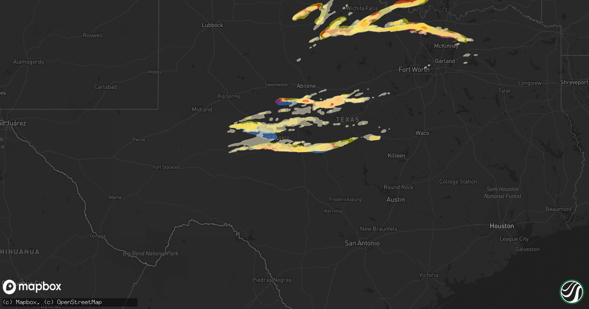
Hail Map in Texas on May 25, 2024
Get this storm
May 25 map
$229
one time, instant access
Download today. No call, no setup
Keep the $229
Bought the map and want the full workflow? Apply the entire $229 to a subscription within 7 days. None of it is wasted.
Every map, not just this one
This buys you this map. Subscription and you get every map we run, in the markets you choose from a few cities to whole states to nationwide. Plus real-time alerts the moment a storm fires.
Contact data
Name, contact info, occupancy, even credit band for addresses in the footprint. You go from where it hit to who to call.
Become the source they trust
Unlimited branding weather history reports on demand. You already have the documented answer ready for the property owner, and you are the one who showed up with it.
Property data and RoofTrace estimates
Pull up any address you have got, its value and the exact code rules for that jurisdiction, straight from One Click Code. Then RoofTrace estimates the squares, pitch, and roof value, priced the way you price.
Storm reports in Texas
Texas
| Date | Description |
|---|---|
| 05/25/20246:45 PM CDT | Report of ping pong ball size hail se of gorman. |
| 05/25/20245:47 PM CDT | Tornado reported by trained spotter 6 w of rising star. |
| 05/25/20245:42 PM CDT | Law enforcement reported a brief tornado touching down right on the callahan/eastland county line. |
| 05/25/20245:37 PM CDT | A local report indicates a tornado near 5 WSW Bluegrove |
| 05/25/20245:16 PM CDT | Tornado observed near windthorst... Starting at 516 pm and lasting until approximately 525pm. |
| 05/25/20245:12 PM CDT | Report from mping: quarter . |
| 05/25/20245:12 PM CDT | Report from mping: quarter |
| 05/25/20245:06 PM CDT | A local report indicates 2.50 inch wind near 10 W Cross Plains |
| 05/25/20245:02 PM CDT | Time estimated based on radar. |
| 05/25/20244:52 PM CDT | Photo of tennis ball hail 10 e of cross plains shared on social media. |
| 05/25/20244:40 PM CDT | Coleman co. Dispatch reported in tennis to golf ball size hail along the coleman-callahan county line on 206. |
| 05/25/20243:50 PM CDT | Hen egg to tennis ball sized hail falling near lawn. |
| 05/25/20243:48 PM CDT | Tornado on ground reported by trained spotter on fm1770 and fm382 looking north 1 to 2 miles. Visible dirt and dust kicking up from the base. |
| 05/25/20243:44 PM CDT | A local report indicates 1.75 inch wind near Lawn |
| 05/25/20243:44 PM CDT | Ne. |
| 05/25/20243:43 PM CDT | Taylor co. Sheriff called to report a tornado on the ground south of lawn just north of the runnels county line. |
| 05/25/20243:20 PM CDT | A local report indicates 1.00 inch wind near 5 SE Seymour |
| 05/25/20242:32 PM CDT | A local report indicates 72 MPH wind near Blackwell |
| 05/25/20242:12 PM CDT | Report from mping: hen egg |
| 05/25/202411:40 AM CDT | Delayed report quarter-size hail reported just south of van alstyne. |
| 05/25/20245:04 AM CDT | Multiple trees blown over or snapped. |
| 05/25/20244:33 AM CDT | So reports golf ball size hail in eden. Time estimated via radar. |
| 05/25/20243:30 AM CDT | Report of quarter size hail via social media. Time estimated from radar. |
| 05/25/20243:21 AM CDT | A local report indicates 1.00 inch wind near Mertzon |
| 05/25/20241:45 AM CDT | Delayed report. Several reports of wind damage in the carlsbad area... Including large tree limbs and small trees knocked down. |
| 05/25/20241:40 AM CDT | Delayed report. Several reports of wind damage in the water valley area... Including large tree limbs... Small trees knocked down... Property damage and metal sheets to |
| 05/25/20241:05 AM CDT | Quarter size hail falling in sterling city. |
| 05/24/202411:36 PM CDT | Delayed report mping report of ping pong sized hail on the south side of sherman. |
| 05/24/202411:34 PM CDT | Report from mping: quarter |
| 05/24/202411:22 PM CDT | Delayed report received multiple reports of a tornado crossing hwy 289 north of celina with reports of residential damage near hwy 289 and cr 100. More structural damag |
| 05/24/202411:20 PM CDT | Report from mping: quarter |
| 05/24/202411:04 PM CDT | Report of measured 70 mph wind gust at near bus 377 and fm 377. Time estimated via radar. |
| 05/24/202410:50 PM CDT | Delayed report golf ball sized hail reported north of valley view. |
| 05/24/202410:44 PM CDT | Received multiple reports of tornado damage from spotters and social media near lone oak rd and i35 in between valley view and sanger near the cooke and denton county l |
| 05/24/202410:40 PM CDT | Downer power lines east of sanger. |
| 05/24/202410:40 PM CDT | Delayed report 3 inch hail reported in mountain springs... East of valley view. |
| 05/24/202410:34 PM CDT | Report of moderate amount of nickel to quarter sized hail in era. |
| 05/24/202410:22 PM CDT | Measured 70 mph wind gust off of fm 922 near rosston tower. |
| 05/24/202410:00 PM CDT | Delayed report half-dollar sized hail reported 2 miles north of forestburg in montague county. |
| 05/24/20249:55 PM CDT | Delayed report received several reports of tornado damage south of forestburg in southeast montague county toward rosston in southwest cooke county. Significant tree da |
| 05/24/20249:37 PM CDT | Union pacific track inspector encountered a large tree down across the tracks approximately 3 miles south of bowie... Tx. Time estimated via radar. |
| 05/24/20249:10 PM CDT | Ping pong ball size hail at jordan and brush road southeast of bowie. |
| 05/24/20248:39 PM CDT | Ping pong ball size hail at cole and 101 south of bowie. |
All States Impacted by Hail Map on May 25, 2024
Cities Impacted by Hail Map on May 25, 2024
- Lebanon, TN
- Hartsville, TN
- Riddleton, TN
- Dixon Springs, TN
- Scotts Hill, TN
- Sardis, TN
- Reagan, TN
- Decaturville, TN
- Monticello, AR
- Crossville, AL
- Albertville, AL
- Springville, AL
- Ashville, AL
- Odenville, AL
- Grady, AR
- Dumas, AR
- Jasper, TN
- Tillar, AR
- Steele, AL
- Pell City, AL
- Talladega, AL
- Pickens, AR
- Winchester, AR
- Ragland, AL
- Lincoln, AL
- Riverside, AL
- Alpine, AL
- Goodwater, AL
- Clanton, AL
- Autaugaville, AL
- Billingsley, AL
- Rockford, AL
- Verbena, AL
- Prattville, AL
- Deatsville, AL
- Marbury, AL
- Jefferson, OH
- Pierpont, OH
- Dacula, GA
- Wetumpka, AL
- Equality, AL
- Montgomery, AL
- Conneautville, PA
- Titus, AL
- Transfer, PA
- Greenville, PA
- Cambridge Springs, PA
- Mercer, PA
- Fredonia, PA
- Macon, GA
- Ramer, AL
- Mathews, AL
- Grady, AL
- Goshen, AL
- Troy, AL
- Knox, PA
- Shippenville, PA
- Purlear, NC
- Cadwell, GA
- Marble, PA
- Butler, PA
- Rentz, GA
- Kellyton, AL
- Aliquippa, PA
- Monaca, PA
- Letohatchee, AL
- Soperton, GA
- Alamo, GA
- McRae Helena, GA
- Dublin, GA
- Brundidge, AL
- Ariton, AL
- Cordele, GA
- Delta, UT
- Blackwell, TX
- Enterprise, AL
- Ozark, AL
- Arabi, GA
- New Zion, SC
- Verona, PA
- Oakmont, PA
- Portal, GA
- Statesboro, GA
- Allison Park, PA
- Glenshaw, PA
- Greenville, AL
- Fort Deposit, AL
- Weinert, TX
- Fort Rucker, AL
- Marion, AL
- Marion Junction, AL
- Vero Beach, FL
- Maryneal, TX
- Selma, AL
- Pittsburgh, PA
- Cheswick, PA
- Pineview, GA
- Indianola, PA
- Tuscola, TX
- Wingate, TX
- Crowell, TX
- Seymour, TX
- Throckmorton, TX
- Haskell, TX
- Fort Pierce, FL
- Titusville, FL
- Munday, TX
- Goree, TX
- Georgetown, SC
- Salem, OH
- Columbiana, OH
- Leetonia, OH
- Millbrook, AL
- Gypsum, CO
- Eagle, CO
- Wolcott, CO
- Bond, CO
- Vail, CO
- Silverthorne, CO
- Avon, CO
- Edwards, CO
- Ovalo, TX
- Jones, AL
- Coosada, AL
- Prosperity, PA
- Washington, PA
- Pamplico, SC
- Noxapater, MS
- Chillicothe, TX
- Tyler, AL
- Lawn, TX
- Scooba, MS
- Emelle, AL
- Rutledge, AL
- Luverne, AL
- Cocoa, FL
- Eclectic, AL
- Amity, PA
- Acme, PA
- Mount Pleasant, PA
- Philadelphia, MS
- Odell, TX
- Vernon, TX
- Epes, AL
- Stamford, TX
- Hamlin, TX
- Newcastle, TX
- Louisville, MS
- Electra, TX
- Washingtonville, OH
- Merritt Island, FL
- Goldsboro, TX
- Clyde, TX
- Holliday, TX
- Olney, TX
- Hayneville, AL
- Davidson, OK
- Frederick, OK
- Dodson, MT
- Livingston, AL
- Shuqualak, MS
- Olustee, OK
- Elmer, OK
- Harrold, TX
- Oklaunion, TX
- Eldorado, OK
- Hay Springs, NE
- Headrick, OK
- Altus, OK
- Tipton, OK
- Malta, MT
- Macon, MS
- Aliceville, AL
- Hookstown, PA
- Baird, TX
- Cross Plains, TX
- Industry, PA
- Georgetown, PA
- Midland, PA
- Shippingport, PA
- Clinton, PA
- Snyder, OK
- Abilene, TX
- Chadron, NE
- Hoboken, GA
- Hollister, OK
- Imperial, PA
- Blair, OK
- Mountain Park, OK
- Bulger, PA
- McDonald, PA
- Coraopolis, PA
- Oakdale, PA
- Burgettstown, PA
- Roseboro, NC
- Brooksville, MS
- Avella, PA
- Roosevelt, OK
- Hobart, OK
- Mckeesport, PA
- North Versailles, PA
- McKees Rocks, PA
- Beaver, OK
- Laverne, OK
- Gate, OK
- Beaver, PA
- Windthorst, TX
- Andrews, SC
- Kingstree, SC
- Lone Wolf, OK
- Loveland, OK
- Burkett, TX
- Gotebo, OK
- Mountain View, OK
- Cordell, OK
- Carnegie, OK
- Carnegie, PA
- Presto, PA
- Morgan, PA
- Bridgeville, PA
- Altus Afb, OK
- Mangum, OK
- Dill City, OK
- Sentinel, OK
- Rocky, OK
- Indiahoma, OK
- Cache, OK
- Chattanooga, OK
- Lawton, OK
- Wexford, PA
- Valencia, PA
- Gibsonia, PA
- Randlett, OK
- Lowndesboro, AL
- Forgan, OK
- Sewickley, PA
- Burkburnett, TX
- Houston, PA
- Canonsburg, PA
- Strabane, PA
- Eighty Four, PA
- Cisco, TX
- Rising Star, TX
- Baden, PA
- Archer City, TX
- Crawford, MS
- Starkville, MS
- Conway, PA
- Ambridge, PA
- Freedom, PA
- De Kalb, MS
- Scotland, TX
- New Kensington, PA
- Carrollton, AL
- Eutaw, AL
- Devol, OK
- Canadian, TX
- Arnett, OK
- Homestead, PA
- Englewood, KS
- Rosston, OK
- Warrendale, PA
- Mars, PA
- Bradfordwoods, PA
- Meade, KS
- South Park, PA
- Bethel Park, PA
- Higgins, TX
- Grover, CO
- Ashland, KS
- Minneola, KS
- Bucklin, KS
- Ford, KS
- Colony, OK
- Corn, OK
- Hydro, OK
- Hinton, OK
- Apache, OK
- Ralph, AL
- Knoxville, AL
- Porterville, MS
- Bazine, KS
- Ness City, KS
- Shattuck, OK
- Henrietta, TX
- Iowa Park, TX
- Anadarko, OK
- Zebulon, NC
- Abbeville, GA
- Foss, OK
- Bessie, OK
- Clinton, OK
- Weatherford, OK
- North Lima, OH
- Fargo, OK
- Gage, OK
- Woodward, OK
- Sharon, OK
- Merriman, NE
- Comanche, OK
- Walters, OK
- Geary, OK
- Reform, AL
- Sycamore, PA
- Buhl, AL
- Protection, KS
- Wichita Falls, TX
- Coleman, TX
- Fayetteville, NC
- Fort Supply, OK
- Buffalo, OK
- Mooreland, OK
- Mullinville, KS
- Offerle, KS
- Spearville, KS
- Greensburg, KS
- Kinsley, KS
- Carbon, TX
- Watonga, OK
- Coldwater, KS
- Tuscaloosa, AL
- Fosters, AL
- Greenfield, OK
- Plainville, KS
- Ringgold, TX
- Nocona, TX
- Bellevue, TX
- Calumet, OK
- Waynesburg, PA
- Mount Morris, PA
- Morgantown, WV
- Pursglove, WV
- Maidsville, WV
- Mutual, OK
- Chester, OK
- De Leon, TX
- Gorman, TX
- Seiling, OK
- Taloga, OK
- Spraggs, PA
- Gainesville, AL
- Elrod, AL
- Gordo, AL
- Echola, AL
- Kingfisher, OK
- Northport, AL
- Omega, OK
- Comanche, TX
- Freedom, OK
- Alva, OK
- Thomas, OK
- Okarche, OK
- Hitchcock, OK
- Ames, OK
- Loyal, OK
- Okeene, OK
- Isabella, OK
- Dover, OK
- Hennessey, OK
- Waukomis, OK
- Drummond, OK
- Bison, OK
- Fairview, OK
- Wilmore, KS
- Lake City, KS
- Natoma, KS
- Ellis, KS
- Cottondale, AL
- Bogue, KS
- Otis, CO
- Hardtner, KS
- Hill City, KS
- Miami, FL
- Longdale, OK
- Ringwood, OK
- Meno, OK
- Ryan, OK
- Terral, OK
- Midway, PA
- Cedarbluff, MS
- Medicine Lodge, KS
- Fellsmere, FL
- Sumter, SC
- Brookwood, AL
- Kiowa, KS
- Sharon, KS
- Lahoma, OK
- Carrier, OK
- Enid, OK
- Hazelton, KS
- Kremlin, OK
- Nash, OK
- Stockton, KS
- Penokee, KS
- West Point, MS
- Cleo Springs, OK
- Dublin, TX
- Ringling, OK
- Pond Creek, OK
- Glade, KS
- Kirwin, KS
- Seven Springs, NC
- Mount Olive, NC
- Wilson, OK
- Preston, MS
- Summerton, SC
- Waynoka, OK
- Waldron, KS
- Attica, KS
- Anthony, KS
- Harper, KS
- Goltry, OK
- Helena, OK
- Jet, OK
- Cherokee, OK
- Carmen, OK
- Burlington, OK
- Amorita, OK
- Bluff City, KS
- Manchester, OK
- Wakita, OK
- Osborne, KS
- Bonneau, SC
- Carmichaels, PA
- Woodston, KS
- Downs, KS
- Medford, OK
- Caldwell, KS
- Aline, OK
- Burneyville, OK
- Leon, OK
- Dacoma, OK
- Kinston, NC
- New Smyrna Beach, FL
- Daytona Beach, FL
- La Grange, NC
- Deep Run, NC
- Stephenville, TX
- Gaylord, KS
- Alton, KS
- Glen Elder, KS
- Trenton, NE
- Tipton, KS
- Marietta, OK
- Overbrook, OK
- Douglas, OK
- Fairmont, OK
- Isabel, KS
- Ardmore, OK
- Cawker City, KS
- Mankato, KS
- Beloit, KS
- Garber, OK
- Covington, OK
- Perry, OK
- Lucien, OK
- Randall, KS
- Portis, KS
- Culbertson, NE
- Danville, KS
- Hunter, OK
- Ranger, TX
- Desdemona, TX
- Marshall, OK
- Madill, OK
- Orlando, OK
- Norway, KS
- McCook, NE
- Jewell, KS
- Cedar, KS
- Curtis, NE
- Chandlersville, OH
- Blue Rock, OH
- Bowie, TX
- Jamestown, KS
- Stillwater, OK
- Freeport, KS
- Argonia, KS
- Mayfield, KS
- Milan, KS
- South Haven, KS
- Wellington, KS
- Viola, KS
- Conway Springs, KS
- Clearwater, KS
- Goddard, KS
- Colwich, KS
- Wichita, KS
- Peck, KS
- Sedgwick, KS
- Bentley, KS
- Haysville, KS
- Belle Plaine, KS
- Valley Center, KS
- Maize, KS
- Mulvane, KS
- Newton, KS
- Derby, KS
- Geuda Springs, KS
- Oxford, KS
- Mcconnell Afb, KS
- Kechi, KS
- Rose Hill, KS
- Greenwich, KS
- Andover, KS
- Augusta, KS
- Benton, KS
- Billings, OK
- Red Rock, OK
- Winfield, KS
- Arkansas City, KS
- Andale, KS
- Garden Plain, KS
- Cheney, KS
- Milton, KS
- Norwich, KS
- Eustis, NE
- Concordia, KS
- Scandia, KS
- Belleville, KS
- Tonkawa, OK
- Mahaska, KS
- Jacksboro, TX
- Lamont, OK
- Blackwell, OK
- Ponca City, OK
- Morrison, OK
- Glencoe, OK
- Sunset, TX
- Forestburg, TX
- Montague, TX
- Bluff Dale, TX
- Udall, KS
- Maple City, KS
- Dexter, KS
- Haddam, KS
- Narka, KS
- Esbon, KS
- Agenda, KS
- Cuba, KS
- Morrowville, KS
- Washington, KS
- Saint Jo, TX
- Tolar, TX
- Columbus, MS
- Pawnee, OK
- Mannsville, OK
- Muenster, TX
- Rosston, TX
- Naponee, NE
- Bloomington, NE
- Rock, KS
- Atlanta, KS
- Ethelsville, AL
- Lewisville, OH
- Hollenberg, KS
- Hanover, KS
- Gainesville, TX
- Valley View, TX
- Marysville, KS
- Bremen, KS
- Odell, NE
- Sylvan Grove, KS
- Woodsfield, OH
- Marland, OK
- Lucas, KS
- Hunter, KS
- Burden, KS
- Diller, NE
- Clyde, KS
- Douglass, KS
- Latham, KS
- Leon, KS
- Cambridge, KS
- Lewis, KS
- Beatrice, NE
- De Witt, NE
- Pickrell, NE
- Alma, NE
- Sterling, KS
- Sardis, OH
- Halstead, KS
- North Newton, KS
- Whitewater, KS
- Walton, KS
- Peabody, KS
- Elbing, KS
- Florence, KS
- Burns, KS
- Towanda, KS
- El Dorado, KS
- Potwin, KS
- Oketo, KS
- Waterville, KS
- Home, KS
- Blue Rapids, KS
- Frankfort, KS
- Beattie, KS
- Fairfax, OK
- Ralston, OK
- Barnard, KS
- Era, TX
- Barnes, KS
- Greenleaf, KS
- Hesston, KS
- Lyons, KS
- Little River, KS
- Brookville, KS
- Salina, KS
- Tescott, KS
- Randolph, KS
- Bennington, KS
- Minneapolis, KS
- Clay Center, KS
- Ellsworth, KS
- Green, KS
- Kanopolis, KS
- Olsburg, KS
- Herington, KS
- Riley, KS
- Woodbine, KS
- Lost Springs, KS
- Fort Riley, KS
- Junction City, KS
- Marion, KS
- Manhattan, KS
- Lincolnville, KS
- Ramona, KS
- Waldo, KS
- Russell, KS
- Luray, KS
- Clifton, KS
- Palmer, KS
- Aurora, KS
- Victoria, KS
- Glasco, KS
- Hays, KS
- Burbank, OK
- Galva, KS
- Canton, KS
- Lincoln, KS
- Seneca, KS
- Summerfield, KS
- Axtell, KS
- Burchard, NE
- Wymore, NE
- Hominy, OK
- Beverly, KS
- Hillsboro, KS
- Pawnee City, NE
- Baileyville, KS
- Lehigh, KS
- Durham, KS
- Decatur, TX
- Wynona, OK
- Saint Paul, KS
- Cleveland, OK
- Sanger, TX
- Pawhuska, OK
- Barnsdall, OK
- Skiatook, OK
- Du Bois, NE
- Centralia, KS
- Westmoreland, KS
- Silver Creek, NE
- Schuyler, NE
- Osceola, NE
- Falls City, NE
- Onaga, KS
- Clarks, NE
- Venetia, PA
- Finleyville, PA
- McCune, KS
- Girard, KS
- Vermillion, KS
- Kennebec, SD
- Rogers, NE
- Delphos, KS
- Prue, OK
- Ramona, OK
- Paola, KS
- Osawatomie, KS
- Spring Hill, KS
- Bucyrus, KS
- Drexel, MO
- Louisburg, KS
- Stilwell, KS
- Cleveland, MO
- Raymore, MO
- Belton, MO
- Peculiar, MO
- Freeman, MO
- Harrisonville, MO
- Pleasant Hill, MO
- Bern, KS
- Sabetha, KS
- Oneida, KS
- Wetmore, KS
- Fairview, KS
- Netawaka, KS
- Goff, KS
- Corning, KS
- Tampa, KS
- Columbus, NE
- Bellwood, NE
- Franklin, NE
- Riverton, NE
- Craig, MO
- Collinsville, TX
- Weir, KS
- Pittsburg, KS
- Cherokee, KS
- Tioga, TX
- Burdick, KS
- Dodge, NE
- Orleans, NE
- Pilot Point, TX
- Lindsay, TX
- Humboldt, NE
- Table Rock, NE
- Fullerton, NE
- Hooper, NE
- Scribner, NE
- Phillipsburg, KS
- Wilsey, KS
- Morrill, KS
- Powhattan, KS
- Collinsville, OK
- Vera, OK
- Talala, OK
- Oologah, OK
- Gunter, TX
- North Bend, NE
- Fairfax, MO
- Agra, KS
- Kensington, KS
- Kansas City, MO
- Olathe, KS
- New Century, KS
- Gardner, KS
- Edgerton, KS
- Lenexa, KS
- Leawood, KS
- Overland Park, KS
- Grandview, MO
- Prairie Village, KS
- Blue Springs, MO
- Grain Valley, MO
- Sibley, MO
- Lees Summit, MO
- Oak Grove, MO
- Buckner, MO
- Independence, MO
- Greenwood, MO
- Odessa, MO
- Bates City, MO
- Holden, MO
- Lone Jack, MO
- Kingsville, MO
- Napoleon, MO
- Strasburg, MO
- Council Grove, KS
- Horton, KS
- Whiting, KS
- Claremore, OK
- Longford, KS
- Rock Port, MO
- Celina, TX
- Howe, TX
- Van Alstyne, TX
- Anna, TX
- Owasso, OK
- Chelsea, OK
- Adair, OK
- Pryor, OK
- Alma, KS
- Alta Vista, KS
- Allen, KS
- Herman, NE
- Craig, NE
- Hiawatha, KS
- Mondamin, IA
- Genoa, NE
- Monroe, NE
- Everest, KS
- Whitewright, TX
- Blue Ridge, TX
- Honey Creek, IA
- McClelland, IA
- Council Bluffs, IA
- Carter Lake, IA
- Crescent, IA
- Omaha, NE
- Underwood, IA
- Highland, KS
- White Cloud, KS
- Robinson, KS
- Troy, KS
- Oregon, MO
- Denton, KS
- Bendena, KS
- Wathena, KS
- Lancaster, KS
- Atchison, KS
- Muscotah, KS
- Effingham, KS
- Tekamah, NE
- Norton, KS
- Cuddy, PA
- Sturgeon, PA
- Big Cabin, OK
- Strang, OK
- Emlenton, PA
- Kennerdell, PA
- Hadley, PA
- West Mifflin, PA
- Hickory, PA
- Chapman, KS
- Leonard, TX
- Trenton, TX
- Chester, WV
- Pisgah, IA
- Milford, KS
- Harrisonville, PA
- Mission, KS
- Levasy, MO
- Shawnee, KS
- Kansas City, KS
- Lebanon, KS
- Fair Play, MO
- Celeste, TX
- Cedar Vale, KS
- Eskridge, KS
- Harveyville, KS
- Reading, KS
- Vinita, OK
- Salina, OK
- Spavinaw, OK
- Farmersville, TX
- Republican City, NE
- Dunnegan, MO
- Lexington, MO
- Orrick, MO
- Wellington, MO
- Braman, OK
- Newkirk, OK
- Shidler, OK
- Burlingame, KS
- Osage City, KS
- Jay, OK
- Eucha, OK
- Colcord, OK
- Burr Oak, KS
- Wolfe City, TX
- Bolivar, MO
- Appleton City, MO
- Greenville, TX
- La Vista, NE
- Bellevue, NE
- Papillion, NE
- Gretna, NE
- Boys Town, NE
- Springfield, NE
- Eufaula, OK
- Garden City, TX
- Scranton, KS
- Sedan, KS
- Antlers, OK
- Checotah, OK
- Peru, KS
- Chautauqua, KS
- Cambridge, IA
- Nevada, IA
- Ames, IA
- Moyers, OK
- Diagonal, IA
- Courtland, KS
- Quenemo, KS
- Overbrook, KS
- Sterling City, TX
- Maysville, AR
- Gravette, AR
- Decatur, AR
- Commerce, TX
- Gentry, AR
- Formoso, KS
- Maple Hill, KS
- Story City, IA
- Niotaze, KS
- Caney, KS
- Roland, IA
- Havana, KS
- Topeka, KS
- Sherman, TX
- Porum, OK
- Carlsbad, TX
- Unionville, MO
- Murray, IA
- Mertzon, TX
- Robert Lee, TX
- Independence, KS
- Big Lake, TX
- Elk City, KS
- Iowa Falls, IA
- Eldora, IA
- Tyro, KS
- Coffeyville, KS
- Copan, OK
- Hiwasse, AR
- Bentonville, AR
- Wann, OK
- Centerton, AR
- Bella Vista, AR
- Livonia, MO
- Wellsburg, IA
- Dearing, KS
- Liberty, KS
- S Coffeyville, OK
- Bartlesville, OK
- Dewey, OK
- Lytton, IA
- Sac City, IA
- San Angelo, TX
- Steamboat Rock, IA
- Ackley, IA
- Bronte, TX
- Aplington, IA
- Moulton, IA
- Exline, IA
- Glenwood, MO
- Lancaster, MO
- Wagoner, OK
- Hulbert, OK
- Rogers, AR
- Fort Gibson, OK
- Lenapah, OK
- Downing, MO
- Cincinnati, IA
- Pea Ridge, AR
- Garfield, AR
- Bloomfield, IA
- Cherryvale, KS
- Winters, TX
- Coatsville, MO
- Memphis, MO
- Pulaski, IA
- Welch, OK
- Edna, KS
- Delaware, OK
- Henryetta, OK
- Austinville, IA
- Bluejacket, OK
- Mound Valley, KS
- Bartlett, KS
- Chetopa, KS
- Goodfellow Afb, TX
- High Hill, MO
- Cantril, IA
- Afton, OK
- Drakesville, IA
- Albia, IA
- Milton, IA
- Belle Plaine, IA
- Marengo, IA
- New Florence, MO
- Mount Pleasant, IA
- White City, KS
- Dwight, KS
- Philadelphia, MO
- Monroe City, MO
- Eureka Springs, AR
- Lowell, AR
- Cave Springs, AR
- Hindsville, AR
- Picher, OK
- Miami, OK
- Mitchellville, IA
- Montgomery City, MO
- Ballinger, TX
- Blairstown, IA
- Van Horne, IA
- Norton, TX
- Miles, TX
- Grove, OK
- Wyandotte, OK
- Anderson, MO
- Tiff City, MO
- Mount Union, IA
- State Center, IA
- Rhodes, IA
- Miltonvale, KS
- Abilene, KS
- Solomon, KS
- Luzerne, IA
- New London, IA
- Winfield, IA
- Palmyra, MO
- Fairland, OK
- Colfax, IA
- Springdale, AR
- Huntsville, AR
- Middletown, MO
- Bellflower, MO
- New London, MO
- Strong City, KS
- Emporia, KS
- Neosho, MO
- Seneca, MO
- Nowata, OK
- Commerce, OK
- Quapaw, OK
- North Miami, OK
- Stockton, MO
- Grinnell, IA
- Keystone, IA
- Mingo, IA
- Novice, TX
- Barnhart, TX
- Berryville, AR
- Morning Sun, IA
- Yarmouth, IA
- Malcom, IA
- Goodman, MO
- Hull, IL
- Hannibal, MO
- Sully, IA
- Lynnville, IA
- Newton, IA
- Talpa, TX
- Rowena, TX
- Joplin, MO
- Victor, IA
- Montezuma, IA
- Brooklyn, IA
- Hartwick, IA
- Marshalltown, IA
- Ladora, IA
- Talmage, KS
- Liberty, IL
- Kinderhook, IL
- Plainville, IL
- Barry, IL
- Payson, IL
- Green Forest, AR
- Valera, TX
- Alpena, AR
- Harrison, AR
- Omaha, AR
- Granby, MO
- North Liberty, IA
- Solon, IA
- Powell, MO
- Pineville, MO
- Garwin, IA
- Traer, IA
- Gladbrook, IA
- Toledo, IA
- Chelsea, IA
- South West City, MO
- Stella, MO
- Stark City, MO
- Camp Point, IL
- Clayton, IL
- Walnut Shade, MO
- Forsyth, MO
- Clutier, IA
- Elberon, IA
- Parsons, KS
- Rocky Comfort, MO
- Norway, IA
- Galena, KS
- Fairview, MO
- Purdy, MO
- Exeter, MO
- Cassville, MO
- Butterfield, MO
- Wheaton, MO
- Washburn, MO
- Buckingham, IA
- Basco, IL
- Carthage, IL
- Watkins, IA
- Amana, IA
- La Porte City, IA
- May, TX
- Brownwood, TX
- Dysart, IA
- Ely, IA
- Warrensburg, MO
- Higginsville, MO
- Centerview, MO
- Hudson, IA
- Taneyville, MO
- Lanagan, MO
- Noel, MO
- Pierce City, MO
- Santa Anna, TX
- Columbus Junction, IA
- Centertown, MO
- Marble Falls, AR
- Compton, AR
- Seligman, MO
- Sulphur Springs, AR
- Everton, AR
- Bradleyville, MO
- Ava, MO
- Seymour, MO
- Sarcoxie, MO
- Golden City, MO
- Lockwood, MO
- Iowa City, IA
- Cedar Rapids, IA
- Mount Vernon, IA
- Monett, MO
- Dallas City, IL
- Aurora, MO
- Shell Knob, MO
- Bangs, TX
- Keithsburg, IL
- Muscatine, IA
- Letts, IA
- Mount Sterling, IL
- Yellville, AR
- Yates Center, KS
- Jesup, IA
- Eagle Rock, MO
- Christoval, TX
- Seaton, IL
- Concordia, MO
- Pyatt, AR
- Rushville, IL
- Vinton, IA
- Kimberling City, MO
- Lampe, MO
- Golden, MO
- Galena, MO
- Reeds Spring, MO
- Cape Fair, MO
- Blue Eye, MO
- Waterloo, IA
- Springville, IA
- Mechanicsville, IA
- Martelle, IA
- Lisbon, IA
- Frederick, IL
- Browning, IL
- Wall, TX
- Eola, TX
- Murrayville, IL
- Winchester, IL
- Hartsburg, MO
- Ashland, MO
- Baxter Springs, KS
- Summit, AR
- Columbus, KS
- Riverton, KS
- Moran, KS
- Flippin, AR
- Bull Shoals, AR
- Lakeview, AR
- Cotter, AR
- Gassville, AR
- Vancourt, TX
- Mansfield, MO
- Astoria, IL
- Chandlerville, IL
- Bath, IL
- Jacksonville, IL
- Oak Grove, AR
- Ridgedale, MO
- Carthage, MO
- Mountain Home, AR
- Webb City, MO
- Paint Rock, TX
- Anamosa, IA
- Millington, TN
- Bronson, KS
- Branson, MO
- Hollister, MO
- Midway, AR
- Henderson, AR
- Elizabeth, AR
- Aledo, IL
- Chanute, KS
- Benedict, KS
- Eden, TX
- Kirbyville, MO
- Drummonds, TN
- Munford, TN
- Cedarcreek, MO
- Lead Hill, AR
- Chestnutridge, MO
- Spokane, MO
- Reeds, MO
- Norfork, AR
- Protem, MO
- Peel, AR
- Drury, MO
- Brixey, MO
- Vanzant, MO
- Melvin, TX
- Lohn, TX
- Brady, TX
- Arlington, TX
- Early, TX
- Humboldt, KS
- Millersview, TX
- Alexis, IL
- Rockaway Beach, MO
- Calico Rock, AR
- Isabella, MO
- Theodosia, MO
- Gainesville, MO
- Pontiac, MO
- Rueter, MO
- Oakland, AR
- Puxico, MO
- Mountain Grove, MO
- Viola, AR
- Salem, AR
- Grand Prairie, TX
- Rio, IL
- Oneida, IL
- Woodhull, IL
- Alpha, IL
- Zephyr, TX
- Mullin, TX
- Irving, TX
- Verona, MO
- Gustine, TX
- Priddy, TX
- Gepp, AR
- Petersburg, IL
- Bexar, AR
- Dolph, AR
- Topeka, IL
- Manito, IL
- Rochelle, TX
- Richland Springs, TX
- Sturkie, AR
- Western Grove, AR
- Cabool, MO
- Hamilton, TX
- Camp, AR
- Gamaliel, AR
- Clarkridge, AR
- Pineville, AR
- Valley Springs, AR
- Mammoth Spring, AR
- Royse City, TX
- Birch Tree, MO
- Winona, MO
- Wideman, AR
- Oxford, AR
- Glencoe, AR
- Wiseman, AR
- Violet Hill, AR
- Horseshoe Bend, AR
- Ash Flat, AR
- Goldthwaite, TX
- Fremont, MO
- Terrell, TX
- Thayer, MO
- Zalma, MO
- Caddo Mills, TX
- Couch, MO
- Hardy, AR
- Ravenden, AR
- San Saba, TX
- Lone Oak, TX
- Alton, MO
- West Plains, MO
- Cherokee Village, AR
- Koshkonong, MO
- Pocahontas, AR
- Myrtle, MO
- Quinlan, TX
- Van Buren, MO
- Frontenac, KS
- Brockwell, AR
- Ravenden Springs, AR
- Franklin, AR
- Ellsinore, MO
- Williford, AR
- Union City, TN
- Hickman, KY
- Mindenmines, MO
- Asbury, MO
- Doniphan, MO
- Bell City, MO
- Imboden, AR
- Warm Springs, AR
- Gatewood, MO
- Jonesboro, TX
- Grandin, MO
- Black Rock, AR
- Maynard, AR
- Mill Spring, MO
- East Prairie, MO
- Lamar, MO
- Jasper, MO
- Liberal, MO
- Oronogo, MO
- Poplar Bluff, MO
- Oran, MO
- Peach Orchard, AR
- Corning, AR
- Biggers, AR
- Delaplaine, AR
- Paragould, AR
- Rector, AR
- Knobel, AR
- Datto, AR
- Lafe, AR
- Clinton, IL
- Maroa, IL
- Williamsville, MO
- Star, TX
- Evant, TX
- Fairdealing, MO
- Harviell, MO
- Neelyville, MO
- Clinton, KY
- Naylor, MO
- Success, AR
- Benton, MO
- Oxly, MO
- Pollard, AR
- Qulin, MO
- Piggott, AR
- Marmaduke, AR
- Greenway, AR
- Campbell, MO
- Broseley, MO
- Fisk, MO
- Dudley, MO
- Lometa, TX
- Kell, IL
- Bernie, MO
- Malden, MO
- Downs, IL
- Wapella, IL
- Logan, KS
- Mckinney, TX


