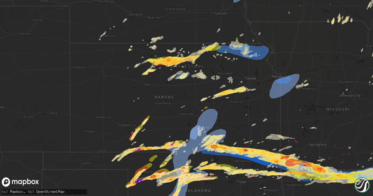
Hail Map in Kansas on May 25, 2024
Get this storm
May 25 map
$229
one time, instant access
Download today. No call, no setup
Keep the $229
Bought the map and want the full workflow? Apply the entire $229 to a subscription within 7 days. None of it is wasted.
Every map, not just this one
This buys you this map. Subscription and you get every map we run, in the markets you choose from a few cities to whole states to nationwide. Plus real-time alerts the moment a storm fires.
Contact data
Name, contact info, occupancy, even credit band for addresses in the footprint. You go from where it hit to who to call.
Become the source they trust
Unlimited branding weather history reports on demand. You already have the documented answer ready for the property owner, and you are the one who showed up with it.
Property data and RoofTrace estimates
Pull up any address you have got, its value and the exact code rules for that jurisdiction, straight from One Click Code. Then RoofTrace estimates the squares, pitch, and roof value, priced the way you price.
Storm reports in Kansas
Kansas
| Date | Description |
|---|---|
| 05/25/20246:55 PM CDT | Report was from social media with pictures. |
| 05/25/20246:55 PM CDT | A local report indicates 1.50 inch wind near Medicine Lodge |
| 05/25/20246:30 PM CDT | Corrects time of previous hail report from 7 ne plainville. |
| 05/25/20246:20 PM CDT | A local report indicates 1.00 inch wind near 7 NE Plainville |
| 05/25/20246:17 PM CDT | A local report indicates 1.50 inch wind near Plainville |
| 05/25/20246:00 PM CDT | Report received from social media. |
| 05/25/20246:00 PM CDT | Mostly pea size hail or smaller. Hail was covering the ground. Did have a few hail stones as large as a half dollar. Report was from social media with pictures. |
| 05/25/20245:54 PM CDT | Report from mping: half dollar |
| 05/25/20245:50 PM CDT | Report received through social media with picture. |
| 05/25/20245:50 PM CDT | A local report indicates 1.75 inch wind near 3 S Buttermilk |
| 05/25/20245:30 PM CDT | Skylights were broken. Window panes were broken and window frames were dented. |
| 05/25/20245:25 PM CDT | A local report indicates 1.00 inch wind near 3 ENE Englewood |
| 05/25/20242:06 AM CDT | A local report indicates 1.50 inch wind near 2 SW Bartlett |
| 05/25/20241:54 AM CDT | Report from mping: quarter |
| 05/25/20241:34 AM CDT | Report from mping: golf ball |
| 05/25/20241:32 AM CDT | A local report indicates 2.50 inch wind near Tyro |
| 05/25/20241:19 AM CDT | A local report indicates 1.75 inch wind near 2 S Tyro |
| 05/25/20241:18 AM CDT | A local report indicates 80 MPH wind near Caney |
| 05/25/20241:13 AM CDT | A local report indicates 1.00 inch wind near 2 S Havana |
| 05/25/20241:10 AM CDT | A local report indicates 1.75 inch wind near Caney |
| 05/25/202412:00 AM CDT | Tree uprooted near 5th street and t street. |
| 05/24/202411:58 PM CDT | Asos station kwld strother field airport. |
| 05/24/202411:54 PM CDT | Knocked down trees and power lines. Delayed report. Time estimated by radar. |
| 05/24/202411:52 PM CDT | Trees and powerlines knocked down. Delayed report. Time estimated by radar. |
| 05/24/202411:40 PM CDT | A local report indicates 1.25 inch wind near 4 ESE Council Grove |
| 05/24/202411:38 PM CDT | Multiple reports of hail ranging from nickel to half dollar in size in the town of norton. |
| 05/24/202411:36 PM CDT | 60 mph wind gusts estimated in huron. |
| 05/24/202411:34 PM CDT | Relayed via kvoe radio. |
| 05/24/202411:25 PM CDT | A local report indicates 1.75 inch wind near 4 E Wilsey |
| 05/24/202411:20 PM CDT | Tree limbs down near state line and 50th. Time estimated from radar. |
| 05/24/202411:20 PM CDT | Several trees down. |
| 05/24/202411:17 PM CDT | Approximately 25 medium to large-sized tree limbs down near ward and 85th. Time estimated from radar. |
| 05/24/202411:15 PM CDT | Powerlines down. |
| 05/24/202411:15 PM CDT | Down trees 12 inches in diameter on the university of kansas edwards campus. |
| 05/24/202411:10 PM CDT | Several large trees blown on to a house near shawnee mission pkwy and antioch. Time estimated. |
| 05/24/202411:07 PM CDT | 5 inch diameter tree limb down... Estimated 60 mph wind... And power out. |
| 05/24/202411:04 PM CDT | A local report indicates 84 MPH wind near 1 NE Lenexa |
| 05/24/202411:03 PM CDT | Large tree down... Time estimated from radar. |
| 05/24/202411:00 PM CDT | A local report indicates 60 MPH wind near 2 NNW Lackmans |
| 05/24/202410:45 PM CDT | A local report indicates 68 MPH wind near 4 W Stanley |
| 05/24/202410:43 PM CDT | A local report indicates 61 MPH wind near 1 WNW Clare |
| 05/24/202410:35 PM CDT | A local report indicates 60 MPH wind near Louisburg |
| 05/24/202410:34 PM CDT | Time estimated via radar. |
| 05/24/202410:26 PM CDT | Trees knocked down. |
| 05/24/202410:22 PM CDT | A local report indicates 58 MPH wind near 3 NNE Vermillion |
| 05/24/202410:20 PM CDT | 50-60 mph wind gust and penny-sized hail reported. |
| 05/24/20249:45 PM CDT | A local report indicates 60 MPH wind near Marysville |
| 05/24/20249:39 PM CDT | Delayed report. 1-inch tree limbs broken; shingles blown off. Time estimated by radar. |
| 05/24/20249:35 PM CDT | Along highway 36 and 5th road. |
| 05/24/20249:32 PM CDT | Reported tree limbs and power lines down in the city. |
| 05/24/20249:19 PM CDT | A local report indicates 70 MPH wind near Udall |
| 05/24/20249:11 PM CDT | Trees and debris blocking sw 60th road. |
| 05/24/20249:10 PM CDT | Report from mping: quarter |
| 05/24/20249:09 PM CDT | A local report indicates 1.00 inch wind near Concordia |
| 05/24/20249:05 PM CDT | A local report indicates 60 MPH wind near Washington |
| 05/24/20248:59 PM CDT | A local report indicates 60 MPH wind near Douglass |
| 05/24/20248:57 PM CDT | A local report indicates 69 MPH wind near 4 ENE Newton |
| 05/24/20248:56 PM CDT | Also estimating 50 mph winds. |
| 05/24/20248:56 PM CDT | Also estimating 50 mph winds. time estimated from radar. |
| 05/24/20248:55 PM CDT | Golf ball size hail via social media. |
| 05/24/20248:55 PM CDT | Corrects previous tstm wnd gst report from udall. |
| 05/24/20248:55 PM CDT | A local report indicates 62 MPH wind near Colwich |
| 05/24/20248:54 PM CDT | A local report indicates 69 MPH wind near 4 ENE Newton |
| 05/24/20248:53 PM CDT | Power lines down reported. |
| 05/24/20248:53 PM CDT | Powerlines are down in the city of halstead. |
| 05/24/20248:49 PM CDT | Mulitple reports of trees down in the city. |
| 05/24/20248:40 PM CDT | A local report indicates 1.25 inch wind near Cawker City |
| 05/24/20248:40 PM CDT | L . |
| 05/24/20248:40 PM CDT | 332 report from mping... Quarter 1.00 in. |
| 05/24/20248:39 PM CDT | Estimated 60-70 mph. |
| 05/24/20248:30 PM CDT | Dispatch center reported ping pong to golf ball size hail ongoing in downs. |
| 05/24/20248:30 PM CDT | Report via picture on social media. |
| 05/24/20248:30 PM CDT | A local report indicates 59 MPH wind near Colwich |
| 05/24/20248:25 PM CDT | Powerlines are reported down. |
| 05/24/20248:24 PM CDT | 8 inch diameter tree snapped onto vehicles. |
| 05/24/20248:24 PM CDT | A local report indicates 78 MPH wind near 1 N Goddard |
| 05/24/20248:21 PM CDT | A local report indicates 72 MPH wind near 1 S Wichita Eisenhower |
| 05/24/20248:16 PM CDT | A local report indicates 1.00 inch wind near 3 SW Portis |
| 05/24/20248:15 PM CDT | Dispatch reported ping pong ball to golf ball size hail in town. |
| 05/24/20248:14 PM CDT | A local report indicates 1.00 inch wind near 4 ENE Glen Elder |
| 05/24/20248:10 PM CDT | Estimated 70-75 mph with 6-10 inch diameter tree limb down. |
| 05/24/20248:00 PM CDT | Photo on social media of hail of varying sizes compared. Largest hailstone was comparable to a quarter. |
| 05/24/20247:58 PM CDT | Trained spotter indicated a roof completely removed off of house. Power lines down as well. |
| 05/24/20247:55 PM CDT | Corrects previous hail report from cawker city. |
| 05/24/20247:55 PM CDT | . |
| 05/24/20247:50 PM CDT | Dispatcher reported ping pong ball size hail falling in town. |
| 05/24/20247:43 PM CDT | A local report indicates 60 MPH wind near 6 N Arkansas City |
| 05/24/20247:42 PM CDT | A local report indicates 74 MPH wind near 7 N Arkansas City |
| 05/24/20247:35 PM CDT | A local report indicates 1.00 inch wind near 5 S Corwin |
| 05/24/20247:32 PM CDT | A local report indicates 2.00 inch wind near 11 NNW Waldron |
| 05/24/20247:32 PM CDT | Delayed report. Trees and powerlines reported down near downtown arkansas city. |
| 05/24/20247:31 PM CDT | Delayed report of a tornado 10 miles west-southwest of anthony. The spotter observed damage. |
| 05/24/20247:27 PM CDT | A local report indicates 1.25 inch wind near 6 S Attica |
| 05/24/20247:20 PM CDT | Report of suspected tornado. |
| 05/24/20247:15 PM CDT | Ef0 tornado developed in hazelton and went ne 1 mile. |
| 05/24/20247:07 PM CDT | A local report indicates 1.75 inch wind near 2 S Medicine Lodge |
| 05/24/20247:00 PM CDT | Cocorahs observer comments noted hail up to quarter size. Time estimated from radar. |
All States Impacted by Hail Map on May 25, 2024
Cities Impacted by Hail Map on May 25, 2024
- Lebanon, TN
- Hartsville, TN
- Riddleton, TN
- Dixon Springs, TN
- Scotts Hill, TN
- Sardis, TN
- Reagan, TN
- Decaturville, TN
- Monticello, AR
- Crossville, AL
- Albertville, AL
- Springville, AL
- Ashville, AL
- Odenville, AL
- Grady, AR
- Dumas, AR
- Jasper, TN
- Tillar, AR
- Steele, AL
- Pell City, AL
- Talladega, AL
- Pickens, AR
- Winchester, AR
- Ragland, AL
- Lincoln, AL
- Riverside, AL
- Alpine, AL
- Goodwater, AL
- Clanton, AL
- Autaugaville, AL
- Billingsley, AL
- Rockford, AL
- Verbena, AL
- Prattville, AL
- Deatsville, AL
- Marbury, AL
- Jefferson, OH
- Pierpont, OH
- Dacula, GA
- Wetumpka, AL
- Equality, AL
- Montgomery, AL
- Conneautville, PA
- Titus, AL
- Transfer, PA
- Greenville, PA
- Cambridge Springs, PA
- Mercer, PA
- Fredonia, PA
- Macon, GA
- Ramer, AL
- Mathews, AL
- Grady, AL
- Goshen, AL
- Troy, AL
- Knox, PA
- Shippenville, PA
- Purlear, NC
- Cadwell, GA
- Marble, PA
- Butler, PA
- Rentz, GA
- Kellyton, AL
- Aliquippa, PA
- Monaca, PA
- Letohatchee, AL
- Soperton, GA
- Alamo, GA
- McRae Helena, GA
- Dublin, GA
- Brundidge, AL
- Ariton, AL
- Cordele, GA
- Delta, UT
- Blackwell, TX
- Enterprise, AL
- Ozark, AL
- Arabi, GA
- New Zion, SC
- Verona, PA
- Oakmont, PA
- Portal, GA
- Statesboro, GA
- Allison Park, PA
- Glenshaw, PA
- Greenville, AL
- Fort Deposit, AL
- Weinert, TX
- Fort Rucker, AL
- Marion, AL
- Marion Junction, AL
- Vero Beach, FL
- Maryneal, TX
- Selma, AL
- Pittsburgh, PA
- Cheswick, PA
- Pineview, GA
- Indianola, PA
- Tuscola, TX
- Wingate, TX
- Crowell, TX
- Seymour, TX
- Throckmorton, TX
- Haskell, TX
- Fort Pierce, FL
- Titusville, FL
- Munday, TX
- Goree, TX
- Georgetown, SC
- Salem, OH
- Columbiana, OH
- Leetonia, OH
- Millbrook, AL
- Gypsum, CO
- Eagle, CO
- Wolcott, CO
- Bond, CO
- Vail, CO
- Silverthorne, CO
- Avon, CO
- Edwards, CO
- Ovalo, TX
- Jones, AL
- Coosada, AL
- Prosperity, PA
- Washington, PA
- Pamplico, SC
- Noxapater, MS
- Chillicothe, TX
- Tyler, AL
- Lawn, TX
- Scooba, MS
- Emelle, AL
- Rutledge, AL
- Luverne, AL
- Cocoa, FL
- Eclectic, AL
- Amity, PA
- Acme, PA
- Mount Pleasant, PA
- Philadelphia, MS
- Odell, TX
- Vernon, TX
- Epes, AL
- Stamford, TX
- Hamlin, TX
- Newcastle, TX
- Louisville, MS
- Electra, TX
- Washingtonville, OH
- Merritt Island, FL
- Goldsboro, TX
- Clyde, TX
- Holliday, TX
- Olney, TX
- Hayneville, AL
- Davidson, OK
- Frederick, OK
- Dodson, MT
- Livingston, AL
- Shuqualak, MS
- Olustee, OK
- Elmer, OK
- Harrold, TX
- Oklaunion, TX
- Eldorado, OK
- Hay Springs, NE
- Headrick, OK
- Altus, OK
- Tipton, OK
- Malta, MT
- Macon, MS
- Aliceville, AL
- Hookstown, PA
- Baird, TX
- Cross Plains, TX
- Industry, PA
- Georgetown, PA
- Midland, PA
- Shippingport, PA
- Clinton, PA
- Snyder, OK
- Abilene, TX
- Chadron, NE
- Hoboken, GA
- Hollister, OK
- Imperial, PA
- Blair, OK
- Mountain Park, OK
- Bulger, PA
- McDonald, PA
- Coraopolis, PA
- Oakdale, PA
- Burgettstown, PA
- Roseboro, NC
- Brooksville, MS
- Avella, PA
- Roosevelt, OK
- Hobart, OK
- Mckeesport, PA
- North Versailles, PA
- McKees Rocks, PA
- Beaver, OK
- Laverne, OK
- Gate, OK
- Beaver, PA
- Windthorst, TX
- Andrews, SC
- Kingstree, SC
- Lone Wolf, OK
- Loveland, OK
- Burkett, TX
- Gotebo, OK
- Mountain View, OK
- Cordell, OK
- Carnegie, OK
- Carnegie, PA
- Presto, PA
- Morgan, PA
- Bridgeville, PA
- Altus Afb, OK
- Mangum, OK
- Dill City, OK
- Sentinel, OK
- Rocky, OK
- Indiahoma, OK
- Cache, OK
- Chattanooga, OK
- Lawton, OK
- Wexford, PA
- Valencia, PA
- Gibsonia, PA
- Randlett, OK
- Lowndesboro, AL
- Forgan, OK
- Sewickley, PA
- Burkburnett, TX
- Houston, PA
- Canonsburg, PA
- Strabane, PA
- Eighty Four, PA
- Cisco, TX
- Rising Star, TX
- Baden, PA
- Archer City, TX
- Crawford, MS
- Starkville, MS
- Conway, PA
- Ambridge, PA
- Freedom, PA
- De Kalb, MS
- Scotland, TX
- New Kensington, PA
- Carrollton, AL
- Eutaw, AL
- Devol, OK
- Canadian, TX
- Arnett, OK
- Homestead, PA
- Englewood, KS
- Rosston, OK
- Warrendale, PA
- Mars, PA
- Bradfordwoods, PA
- Meade, KS
- South Park, PA
- Bethel Park, PA
- Higgins, TX
- Grover, CO
- Ashland, KS
- Minneola, KS
- Bucklin, KS
- Ford, KS
- Colony, OK
- Corn, OK
- Hydro, OK
- Hinton, OK
- Apache, OK
- Ralph, AL
- Knoxville, AL
- Porterville, MS
- Bazine, KS
- Ness City, KS
- Shattuck, OK
- Henrietta, TX
- Iowa Park, TX
- Anadarko, OK
- Zebulon, NC
- Abbeville, GA
- Foss, OK
- Bessie, OK
- Clinton, OK
- Weatherford, OK
- North Lima, OH
- Fargo, OK
- Gage, OK
- Woodward, OK
- Sharon, OK
- Merriman, NE
- Comanche, OK
- Walters, OK
- Geary, OK
- Reform, AL
- Sycamore, PA
- Buhl, AL
- Protection, KS
- Wichita Falls, TX
- Coleman, TX
- Fayetteville, NC
- Fort Supply, OK
- Buffalo, OK
- Mooreland, OK
- Mullinville, KS
- Offerle, KS
- Spearville, KS
- Greensburg, KS
- Kinsley, KS
- Carbon, TX
- Watonga, OK
- Coldwater, KS
- Tuscaloosa, AL
- Fosters, AL
- Greenfield, OK
- Plainville, KS
- Ringgold, TX
- Nocona, TX
- Bellevue, TX
- Calumet, OK
- Waynesburg, PA
- Mount Morris, PA
- Morgantown, WV
- Pursglove, WV
- Maidsville, WV
- Mutual, OK
- Chester, OK
- De Leon, TX
- Gorman, TX
- Seiling, OK
- Taloga, OK
- Spraggs, PA
- Gainesville, AL
- Elrod, AL
- Gordo, AL
- Echola, AL
- Kingfisher, OK
- Northport, AL
- Omega, OK
- Comanche, TX
- Freedom, OK
- Alva, OK
- Thomas, OK
- Okarche, OK
- Hitchcock, OK
- Ames, OK
- Loyal, OK
- Okeene, OK
- Isabella, OK
- Dover, OK
- Hennessey, OK
- Waukomis, OK
- Drummond, OK
- Bison, OK
- Fairview, OK
- Wilmore, KS
- Lake City, KS
- Natoma, KS
- Ellis, KS
- Cottondale, AL
- Bogue, KS
- Otis, CO
- Hardtner, KS
- Hill City, KS
- Miami, FL
- Longdale, OK
- Ringwood, OK
- Meno, OK
- Ryan, OK
- Terral, OK
- Midway, PA
- Cedarbluff, MS
- Medicine Lodge, KS
- Fellsmere, FL
- Sumter, SC
- Brookwood, AL
- Kiowa, KS
- Sharon, KS
- Lahoma, OK
- Carrier, OK
- Enid, OK
- Hazelton, KS
- Kremlin, OK
- Nash, OK
- Stockton, KS
- Penokee, KS
- West Point, MS
- Cleo Springs, OK
- Dublin, TX
- Ringling, OK
- Pond Creek, OK
- Glade, KS
- Kirwin, KS
- Seven Springs, NC
- Mount Olive, NC
- Wilson, OK
- Preston, MS
- Summerton, SC
- Waynoka, OK
- Waldron, KS
- Attica, KS
- Anthony, KS
- Harper, KS
- Goltry, OK
- Helena, OK
- Jet, OK
- Cherokee, OK
- Carmen, OK
- Burlington, OK
- Amorita, OK
- Bluff City, KS
- Manchester, OK
- Wakita, OK
- Osborne, KS
- Bonneau, SC
- Carmichaels, PA
- Woodston, KS
- Downs, KS
- Medford, OK
- Caldwell, KS
- Aline, OK
- Burneyville, OK
- Leon, OK
- Dacoma, OK
- Kinston, NC
- New Smyrna Beach, FL
- Daytona Beach, FL
- La Grange, NC
- Deep Run, NC
- Stephenville, TX
- Gaylord, KS
- Alton, KS
- Glen Elder, KS
- Trenton, NE
- Tipton, KS
- Marietta, OK
- Overbrook, OK
- Douglas, OK
- Fairmont, OK
- Isabel, KS
- Ardmore, OK
- Cawker City, KS
- Mankato, KS
- Beloit, KS
- Garber, OK
- Covington, OK
- Perry, OK
- Lucien, OK
- Randall, KS
- Portis, KS
- Culbertson, NE
- Danville, KS
- Hunter, OK
- Ranger, TX
- Desdemona, TX
- Marshall, OK
- Madill, OK
- Orlando, OK
- Norway, KS
- McCook, NE
- Jewell, KS
- Cedar, KS
- Curtis, NE
- Chandlersville, OH
- Blue Rock, OH
- Bowie, TX
- Jamestown, KS
- Stillwater, OK
- Freeport, KS
- Argonia, KS
- Mayfield, KS
- Milan, KS
- South Haven, KS
- Wellington, KS
- Viola, KS
- Conway Springs, KS
- Clearwater, KS
- Goddard, KS
- Colwich, KS
- Wichita, KS
- Peck, KS
- Sedgwick, KS
- Bentley, KS
- Haysville, KS
- Belle Plaine, KS
- Valley Center, KS
- Maize, KS
- Mulvane, KS
- Newton, KS
- Derby, KS
- Geuda Springs, KS
- Oxford, KS
- Mcconnell Afb, KS
- Kechi, KS
- Rose Hill, KS
- Greenwich, KS
- Andover, KS
- Augusta, KS
- Benton, KS
- Billings, OK
- Red Rock, OK
- Winfield, KS
- Arkansas City, KS
- Andale, KS
- Garden Plain, KS
- Cheney, KS
- Milton, KS
- Norwich, KS
- Eustis, NE
- Concordia, KS
- Scandia, KS
- Belleville, KS
- Tonkawa, OK
- Mahaska, KS
- Jacksboro, TX
- Lamont, OK
- Blackwell, OK
- Ponca City, OK
- Morrison, OK
- Glencoe, OK
- Sunset, TX
- Forestburg, TX
- Montague, TX
- Bluff Dale, TX
- Udall, KS
- Maple City, KS
- Dexter, KS
- Haddam, KS
- Narka, KS
- Esbon, KS
- Agenda, KS
- Cuba, KS
- Morrowville, KS
- Washington, KS
- Saint Jo, TX
- Tolar, TX
- Columbus, MS
- Pawnee, OK
- Mannsville, OK
- Muenster, TX
- Rosston, TX
- Naponee, NE
- Bloomington, NE
- Rock, KS
- Atlanta, KS
- Ethelsville, AL
- Lewisville, OH
- Hollenberg, KS
- Hanover, KS
- Gainesville, TX
- Valley View, TX
- Marysville, KS
- Bremen, KS
- Odell, NE
- Sylvan Grove, KS
- Woodsfield, OH
- Marland, OK
- Lucas, KS
- Hunter, KS
- Burden, KS
- Diller, NE
- Clyde, KS
- Douglass, KS
- Latham, KS
- Leon, KS
- Cambridge, KS
- Lewis, KS
- Beatrice, NE
- De Witt, NE
- Pickrell, NE
- Alma, NE
- Sterling, KS
- Sardis, OH
- Halstead, KS
- North Newton, KS
- Whitewater, KS
- Walton, KS
- Peabody, KS
- Elbing, KS
- Florence, KS
- Burns, KS
- Towanda, KS
- El Dorado, KS
- Potwin, KS
- Oketo, KS
- Waterville, KS
- Home, KS
- Blue Rapids, KS
- Frankfort, KS
- Beattie, KS
- Fairfax, OK
- Ralston, OK
- Barnard, KS
- Era, TX
- Barnes, KS
- Greenleaf, KS
- Hesston, KS
- Lyons, KS
- Little River, KS
- Brookville, KS
- Salina, KS
- Tescott, KS
- Randolph, KS
- Bennington, KS
- Minneapolis, KS
- Clay Center, KS
- Ellsworth, KS
- Green, KS
- Kanopolis, KS
- Olsburg, KS
- Herington, KS
- Riley, KS
- Woodbine, KS
- Lost Springs, KS
- Fort Riley, KS
- Junction City, KS
- Marion, KS
- Manhattan, KS
- Lincolnville, KS
- Ramona, KS
- Waldo, KS
- Russell, KS
- Luray, KS
- Clifton, KS
- Palmer, KS
- Aurora, KS
- Victoria, KS
- Glasco, KS
- Hays, KS
- Burbank, OK
- Galva, KS
- Canton, KS
- Lincoln, KS
- Seneca, KS
- Summerfield, KS
- Axtell, KS
- Burchard, NE
- Wymore, NE
- Hominy, OK
- Beverly, KS
- Hillsboro, KS
- Pawnee City, NE
- Baileyville, KS
- Lehigh, KS
- Durham, KS
- Decatur, TX
- Wynona, OK
- Saint Paul, KS
- Cleveland, OK
- Sanger, TX
- Pawhuska, OK
- Barnsdall, OK
- Skiatook, OK
- Du Bois, NE
- Centralia, KS
- Westmoreland, KS
- Silver Creek, NE
- Schuyler, NE
- Osceola, NE
- Falls City, NE
- Onaga, KS
- Clarks, NE
- Venetia, PA
- Finleyville, PA
- McCune, KS
- Girard, KS
- Vermillion, KS
- Kennebec, SD
- Rogers, NE
- Delphos, KS
- Prue, OK
- Ramona, OK
- Paola, KS
- Osawatomie, KS
- Spring Hill, KS
- Bucyrus, KS
- Drexel, MO
- Louisburg, KS
- Stilwell, KS
- Cleveland, MO
- Raymore, MO
- Belton, MO
- Peculiar, MO
- Freeman, MO
- Harrisonville, MO
- Pleasant Hill, MO
- Bern, KS
- Sabetha, KS
- Oneida, KS
- Wetmore, KS
- Fairview, KS
- Netawaka, KS
- Goff, KS
- Corning, KS
- Tampa, KS
- Columbus, NE
- Bellwood, NE
- Franklin, NE
- Riverton, NE
- Craig, MO
- Collinsville, TX
- Weir, KS
- Pittsburg, KS
- Cherokee, KS
- Tioga, TX
- Burdick, KS
- Dodge, NE
- Orleans, NE
- Pilot Point, TX
- Lindsay, TX
- Humboldt, NE
- Table Rock, NE
- Fullerton, NE
- Hooper, NE
- Scribner, NE
- Phillipsburg, KS
- Wilsey, KS
- Morrill, KS
- Powhattan, KS
- Collinsville, OK
- Vera, OK
- Talala, OK
- Oologah, OK
- Gunter, TX
- North Bend, NE
- Fairfax, MO
- Agra, KS
- Kensington, KS
- Kansas City, MO
- Olathe, KS
- New Century, KS
- Gardner, KS
- Edgerton, KS
- Lenexa, KS
- Leawood, KS
- Overland Park, KS
- Grandview, MO
- Prairie Village, KS
- Blue Springs, MO
- Grain Valley, MO
- Sibley, MO
- Lees Summit, MO
- Oak Grove, MO
- Buckner, MO
- Independence, MO
- Greenwood, MO
- Odessa, MO
- Bates City, MO
- Holden, MO
- Lone Jack, MO
- Kingsville, MO
- Napoleon, MO
- Strasburg, MO
- Council Grove, KS
- Horton, KS
- Whiting, KS
- Claremore, OK
- Longford, KS
- Rock Port, MO
- Celina, TX
- Howe, TX
- Van Alstyne, TX
- Anna, TX
- Owasso, OK
- Chelsea, OK
- Adair, OK
- Pryor, OK
- Alma, KS
- Alta Vista, KS
- Allen, KS
- Herman, NE
- Craig, NE
- Hiawatha, KS
- Mondamin, IA
- Genoa, NE
- Monroe, NE
- Everest, KS
- Whitewright, TX
- Blue Ridge, TX
- Honey Creek, IA
- McClelland, IA
- Council Bluffs, IA
- Carter Lake, IA
- Crescent, IA
- Omaha, NE
- Underwood, IA
- Highland, KS
- White Cloud, KS
- Robinson, KS
- Troy, KS
- Oregon, MO
- Denton, KS
- Bendena, KS
- Wathena, KS
- Lancaster, KS
- Atchison, KS
- Muscotah, KS
- Effingham, KS
- Tekamah, NE
- Norton, KS
- Cuddy, PA
- Sturgeon, PA
- Big Cabin, OK
- Strang, OK
- Emlenton, PA
- Kennerdell, PA
- Hadley, PA
- West Mifflin, PA
- Hickory, PA
- Chapman, KS
- Leonard, TX
- Trenton, TX
- Chester, WV
- Pisgah, IA
- Milford, KS
- Harrisonville, PA
- Mission, KS
- Levasy, MO
- Shawnee, KS
- Kansas City, KS
- Lebanon, KS
- Fair Play, MO
- Celeste, TX
- Cedar Vale, KS
- Eskridge, KS
- Harveyville, KS
- Reading, KS
- Vinita, OK
- Salina, OK
- Spavinaw, OK
- Farmersville, TX
- Republican City, NE
- Dunnegan, MO
- Lexington, MO
- Orrick, MO
- Wellington, MO
- Braman, OK
- Newkirk, OK
- Shidler, OK
- Burlingame, KS
- Osage City, KS
- Jay, OK
- Eucha, OK
- Colcord, OK
- Burr Oak, KS
- Wolfe City, TX
- Bolivar, MO
- Appleton City, MO
- Greenville, TX
- La Vista, NE
- Bellevue, NE
- Papillion, NE
- Gretna, NE
- Boys Town, NE
- Springfield, NE
- Eufaula, OK
- Garden City, TX
- Scranton, KS
- Sedan, KS
- Antlers, OK
- Checotah, OK
- Peru, KS
- Chautauqua, KS
- Cambridge, IA
- Nevada, IA
- Ames, IA
- Moyers, OK
- Diagonal, IA
- Courtland, KS
- Quenemo, KS
- Overbrook, KS
- Sterling City, TX
- Maysville, AR
- Gravette, AR
- Decatur, AR
- Commerce, TX
- Gentry, AR
- Formoso, KS
- Maple Hill, KS
- Story City, IA
- Niotaze, KS
- Caney, KS
- Roland, IA
- Havana, KS
- Topeka, KS
- Sherman, TX
- Porum, OK
- Carlsbad, TX
- Unionville, MO
- Murray, IA
- Mertzon, TX
- Robert Lee, TX
- Independence, KS
- Big Lake, TX
- Elk City, KS
- Iowa Falls, IA
- Eldora, IA
- Tyro, KS
- Coffeyville, KS
- Copan, OK
- Hiwasse, AR
- Bentonville, AR
- Wann, OK
- Centerton, AR
- Bella Vista, AR
- Livonia, MO
- Wellsburg, IA
- Dearing, KS
- Liberty, KS
- S Coffeyville, OK
- Bartlesville, OK
- Dewey, OK
- Lytton, IA
- Sac City, IA
- San Angelo, TX
- Steamboat Rock, IA
- Ackley, IA
- Bronte, TX
- Aplington, IA
- Moulton, IA
- Exline, IA
- Glenwood, MO
- Lancaster, MO
- Wagoner, OK
- Hulbert, OK
- Rogers, AR
- Fort Gibson, OK
- Lenapah, OK
- Downing, MO
- Cincinnati, IA
- Pea Ridge, AR
- Garfield, AR
- Bloomfield, IA
- Cherryvale, KS
- Winters, TX
- Coatsville, MO
- Memphis, MO
- Pulaski, IA
- Welch, OK
- Edna, KS
- Delaware, OK
- Henryetta, OK
- Austinville, IA
- Bluejacket, OK
- Mound Valley, KS
- Bartlett, KS
- Chetopa, KS
- Goodfellow Afb, TX
- High Hill, MO
- Cantril, IA
- Afton, OK
- Drakesville, IA
- Albia, IA
- Milton, IA
- Belle Plaine, IA
- Marengo, IA
- New Florence, MO
- Mount Pleasant, IA
- White City, KS
- Dwight, KS
- Philadelphia, MO
- Monroe City, MO
- Eureka Springs, AR
- Lowell, AR
- Cave Springs, AR
- Hindsville, AR
- Picher, OK
- Miami, OK
- Mitchellville, IA
- Montgomery City, MO
- Ballinger, TX
- Blairstown, IA
- Van Horne, IA
- Norton, TX
- Miles, TX
- Grove, OK
- Wyandotte, OK
- Anderson, MO
- Tiff City, MO
- Mount Union, IA
- State Center, IA
- Rhodes, IA
- Miltonvale, KS
- Abilene, KS
- Solomon, KS
- Luzerne, IA
- New London, IA
- Winfield, IA
- Palmyra, MO
- Fairland, OK
- Colfax, IA
- Springdale, AR
- Huntsville, AR
- Middletown, MO
- Bellflower, MO
- New London, MO
- Strong City, KS
- Emporia, KS
- Neosho, MO
- Seneca, MO
- Nowata, OK
- Commerce, OK
- Quapaw, OK
- North Miami, OK
- Stockton, MO
- Grinnell, IA
- Keystone, IA
- Mingo, IA
- Novice, TX
- Barnhart, TX
- Berryville, AR
- Morning Sun, IA
- Yarmouth, IA
- Malcom, IA
- Goodman, MO
- Hull, IL
- Hannibal, MO
- Sully, IA
- Lynnville, IA
- Newton, IA
- Talpa, TX
- Rowena, TX
- Joplin, MO
- Victor, IA
- Montezuma, IA
- Brooklyn, IA
- Hartwick, IA
- Marshalltown, IA
- Ladora, IA
- Talmage, KS
- Liberty, IL
- Kinderhook, IL
- Plainville, IL
- Barry, IL
- Payson, IL
- Green Forest, AR
- Valera, TX
- Alpena, AR
- Harrison, AR
- Omaha, AR
- Granby, MO
- North Liberty, IA
- Solon, IA
- Powell, MO
- Pineville, MO
- Garwin, IA
- Traer, IA
- Gladbrook, IA
- Toledo, IA
- Chelsea, IA
- South West City, MO
- Stella, MO
- Stark City, MO
- Camp Point, IL
- Clayton, IL
- Walnut Shade, MO
- Forsyth, MO
- Clutier, IA
- Elberon, IA
- Parsons, KS
- Rocky Comfort, MO
- Norway, IA
- Galena, KS
- Fairview, MO
- Purdy, MO
- Exeter, MO
- Cassville, MO
- Butterfield, MO
- Wheaton, MO
- Washburn, MO
- Buckingham, IA
- Basco, IL
- Carthage, IL
- Watkins, IA
- Amana, IA
- La Porte City, IA
- May, TX
- Brownwood, TX
- Dysart, IA
- Ely, IA
- Warrensburg, MO
- Higginsville, MO
- Centerview, MO
- Hudson, IA
- Taneyville, MO
- Lanagan, MO
- Noel, MO
- Pierce City, MO
- Santa Anna, TX
- Columbus Junction, IA
- Centertown, MO
- Marble Falls, AR
- Compton, AR
- Seligman, MO
- Sulphur Springs, AR
- Everton, AR
- Bradleyville, MO
- Ava, MO
- Seymour, MO
- Sarcoxie, MO
- Golden City, MO
- Lockwood, MO
- Iowa City, IA
- Cedar Rapids, IA
- Mount Vernon, IA
- Monett, MO
- Dallas City, IL
- Aurora, MO
- Shell Knob, MO
- Bangs, TX
- Keithsburg, IL
- Muscatine, IA
- Letts, IA
- Mount Sterling, IL
- Yellville, AR
- Yates Center, KS
- Jesup, IA
- Eagle Rock, MO
- Christoval, TX
- Seaton, IL
- Concordia, MO
- Pyatt, AR
- Rushville, IL
- Vinton, IA
- Kimberling City, MO
- Lampe, MO
- Golden, MO
- Galena, MO
- Reeds Spring, MO
- Cape Fair, MO
- Blue Eye, MO
- Waterloo, IA
- Springville, IA
- Mechanicsville, IA
- Martelle, IA
- Lisbon, IA
- Frederick, IL
- Browning, IL
- Wall, TX
- Eola, TX
- Murrayville, IL
- Winchester, IL
- Hartsburg, MO
- Ashland, MO
- Baxter Springs, KS
- Summit, AR
- Columbus, KS
- Riverton, KS
- Moran, KS
- Flippin, AR
- Bull Shoals, AR
- Lakeview, AR
- Cotter, AR
- Gassville, AR
- Vancourt, TX
- Mansfield, MO
- Astoria, IL
- Chandlerville, IL
- Bath, IL
- Jacksonville, IL
- Oak Grove, AR
- Ridgedale, MO
- Carthage, MO
- Mountain Home, AR
- Webb City, MO
- Paint Rock, TX
- Anamosa, IA
- Millington, TN
- Bronson, KS
- Branson, MO
- Hollister, MO
- Midway, AR
- Henderson, AR
- Elizabeth, AR
- Aledo, IL
- Chanute, KS
- Benedict, KS
- Eden, TX
- Kirbyville, MO
- Drummonds, TN
- Munford, TN
- Cedarcreek, MO
- Lead Hill, AR
- Chestnutridge, MO
- Spokane, MO
- Reeds, MO
- Norfork, AR
- Protem, MO
- Peel, AR
- Drury, MO
- Brixey, MO
- Vanzant, MO
- Melvin, TX
- Lohn, TX
- Brady, TX
- Arlington, TX
- Early, TX
- Humboldt, KS
- Millersview, TX
- Alexis, IL
- Rockaway Beach, MO
- Calico Rock, AR
- Isabella, MO
- Theodosia, MO
- Gainesville, MO
- Pontiac, MO
- Rueter, MO
- Oakland, AR
- Puxico, MO
- Mountain Grove, MO
- Viola, AR
- Salem, AR
- Grand Prairie, TX
- Rio, IL
- Oneida, IL
- Woodhull, IL
- Alpha, IL
- Zephyr, TX
- Mullin, TX
- Irving, TX
- Verona, MO
- Gustine, TX
- Priddy, TX
- Gepp, AR
- Petersburg, IL
- Bexar, AR
- Dolph, AR
- Topeka, IL
- Manito, IL
- Rochelle, TX
- Richland Springs, TX
- Sturkie, AR
- Western Grove, AR
- Cabool, MO
- Hamilton, TX
- Camp, AR
- Gamaliel, AR
- Clarkridge, AR
- Pineville, AR
- Valley Springs, AR
- Mammoth Spring, AR
- Royse City, TX
- Birch Tree, MO
- Winona, MO
- Wideman, AR
- Oxford, AR
- Glencoe, AR
- Wiseman, AR
- Violet Hill, AR
- Horseshoe Bend, AR
- Ash Flat, AR
- Goldthwaite, TX
- Fremont, MO
- Terrell, TX
- Thayer, MO
- Zalma, MO
- Caddo Mills, TX
- Couch, MO
- Hardy, AR
- Ravenden, AR
- San Saba, TX
- Lone Oak, TX
- Alton, MO
- West Plains, MO
- Cherokee Village, AR
- Koshkonong, MO
- Pocahontas, AR
- Myrtle, MO
- Quinlan, TX
- Van Buren, MO
- Frontenac, KS
- Brockwell, AR
- Ravenden Springs, AR
- Franklin, AR
- Ellsinore, MO
- Williford, AR
- Union City, TN
- Hickman, KY
- Mindenmines, MO
- Asbury, MO
- Doniphan, MO
- Bell City, MO
- Imboden, AR
- Warm Springs, AR
- Gatewood, MO
- Jonesboro, TX
- Grandin, MO
- Black Rock, AR
- Maynard, AR
- Mill Spring, MO
- East Prairie, MO
- Lamar, MO
- Jasper, MO
- Liberal, MO
- Oronogo, MO
- Poplar Bluff, MO
- Oran, MO
- Peach Orchard, AR
- Corning, AR
- Biggers, AR
- Delaplaine, AR
- Paragould, AR
- Rector, AR
- Knobel, AR
- Datto, AR
- Lafe, AR
- Clinton, IL
- Maroa, IL
- Williamsville, MO
- Star, TX
- Evant, TX
- Fairdealing, MO
- Harviell, MO
- Neelyville, MO
- Clinton, KY
- Naylor, MO
- Success, AR
- Benton, MO
- Oxly, MO
- Pollard, AR
- Qulin, MO
- Piggott, AR
- Marmaduke, AR
- Greenway, AR
- Campbell, MO
- Broseley, MO
- Fisk, MO
- Dudley, MO
- Lometa, TX
- Kell, IL
- Bernie, MO
- Malden, MO
- Downs, IL
- Wapella, IL
- Logan, KS
- Mckinney, TX


