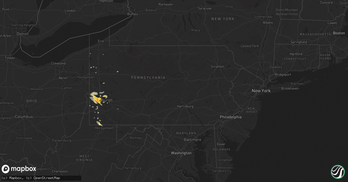
Hail Map in Pennsylvania on May 25, 2024
Get this storm
May 25 map
$229
one time, instant access
Download today. No call, no setup
Keep the $229
Bought the map and want the full workflow? Apply the entire $229 to a subscription within 7 days. None of it is wasted.
Every map, not just this one
This buys you this map. Subscription and you get every map we run, in the markets you choose from a few cities to whole states to nationwide. Plus real-time alerts the moment a storm fires.
Contact data
Name, contact info, occupancy, even credit band for addresses in the footprint. You go from where it hit to who to call.
Become the source they trust
Unlimited branding weather history reports on demand. You already have the documented answer ready for the property owner, and you are the one who showed up with it.
Property data and RoofTrace estimates
Pull up any address you have got, its value and the exact code rules for that jurisdiction, straight from One Click Code. Then RoofTrace estimates the squares, pitch, and roof value, priced the way you price.
Storm reports in Pennsylvania
Pennsylvania
| Date | Description |
|---|---|
| 05/25/20246:11 PM CDT | Tree down on nilan rd |
| 05/25/20246:05 PM CDT | Tree down on sr 166 |
| 05/25/20245:38 PM CDT | Tree down across laird road just west of lake road. |
| 05/25/20245:14 PM CDT | Large branches down on state route 837 at coal bluff road... Blocking the road. Time estimated. |
| 05/25/20244:47 PM CDT | A local report indicates 1.50 inch wind near Hickman |
| 05/25/20244:45 PM CDT | A local report indicates 1.50 inch wind near Rennerdale |
| 05/25/20244:45 PM CDT | Large branches down on route 980... Blocking road. Time estimated from radar. |
| 05/25/20244:41 PM CDT | Picture provided of golf ball hail |
| 05/25/20244:40 PM CDT | A local report indicates 1.00 inch wind near 2 SW Coraopolis |
| 05/25/20244:40 PM CDT | A local report indicates 1.50 inch wind near 3 SSW Coraopolis |
| 05/25/20244:38 PM CDT | Observed along coventry drive |
| 05/25/20244:38 PM CDT | Observed along coventry drive |
| 05/25/20244:37 PM CDT | A local report indicates 1.00 inch wind near N Oakdale |
| 05/25/20244:37 PM CDT | A local report indicates 1.50 inch wind near Avalon |
| 05/25/20244:36 PM CDT | A local report indicates 1.75 inch wind near 1 W Robinson Township |
| 05/25/20244:35 PM CDT | Along prism pl |
| 05/25/20244:34 PM CDT | Golf ball sized hail at the imperial vfd |
| 05/25/20244:34 PM CDT | A local report indicates 1.00 inch wind near 2 E Imperial-Enlow |
| 05/25/20244:33 PM CDT | Penny to half-dollar sized hail |
| 05/25/20244:32 PM CDT | Delayed report - hail measured over 2 inches. |
| 05/25/20244:26 PM CDT | A local report indicates 1.00 inch wind near 1 ENE Clinton |
| 05/25/20244:10 PM CDT | Trees down on mahoning road and university drive. Time estimated from radar. |
| 05/25/20244:03 PM CDT | Tree down on mountain road. Time estimated from radar. |
| 05/25/20244:02 PM CDT | Tree and wires down on rich hill road.... |
| 05/25/20244:00 PM CDT | Trees down along dunbar ohiopyle rd |
| 05/25/20243:59 PM CDT | Trees and wires down on pleasant hills road. Damage connected to a brief ef-0 tornado. |
| 05/25/20243:59 PM CDT | Tree and wires down on pleasant hill road. Possible tornado damage. |
| 05/25/20243:50 PM CDT | Tree down on route 130. Time estimated from radar. |
| 05/25/20243:15 PM CDT | Large branches down on at the 3300 block of vista valley road... Blocking the road. Time estimated. |
| 05/25/20243:00 PM CDT | Tree down on tunnelton road. Time estimated from radar. |
| 05/25/20242:40 PM CDT | Trees down at the intersection of dark hollow road and plum street. Time estimated from radar. |
| 05/25/20242:30 PM CDT | Tree and wires down on ekastown road. Time estimated from radar. |
| 05/25/20242:28 PM CDT | Trees down on cedar run road. Time estimated from radar. |
| 05/25/20242:17 PM CDT | Tree down on rodi road. Time estimated from radar. |
| 05/25/20242:13 PM CDT | Large branches down along oakdale rd just south of us-22 |
| 05/25/20242:10 PM CDT | Trees down at the intersection of sherwodd and morrow roads. Time estimated from radar. |
| 05/25/20242:03 PM CDT | Utility poles and traffic lights down on route 65 |
| 05/25/20242:02 PM CDT | Report from mping: 1-inch tree limbs broken |
| 05/25/20241:55 PM CDT | Tops of trees broken off |
| 05/25/20241:42 PM CDT | Trees down on river road |
| 05/25/20241:40 PM CDT | Trees and wires down in center township |
| 05/25/20241:36 PM CDT | Report from mping: 1-inch tree limbs broken jackson mo 3898 9448 delayed mping report of trees snapped or uprooted in raytown. Time estimated f |
| 05/25/20241:36 PM CDT | Report from mping: 1-inch tree limbs broken |
| 05/25/20241:36 PM CDT | Report from mping: 1-inch tree limbs broken |
| 05/25/20241:34 PM CDT | Trees down on river road |
| 05/25/202412:50 PM CDT | Wires down |
| 05/25/202412:50 PM CDT | Wires down |
| 05/25/202412:02 PM CDT | Down trees |
All States Impacted by Hail Map on May 25, 2024
Cities Impacted by Hail Map on May 25, 2024
- Lebanon, TN
- Hartsville, TN
- Riddleton, TN
- Dixon Springs, TN
- Scotts Hill, TN
- Sardis, TN
- Reagan, TN
- Decaturville, TN
- Monticello, AR
- Crossville, AL
- Albertville, AL
- Springville, AL
- Ashville, AL
- Odenville, AL
- Grady, AR
- Dumas, AR
- Jasper, TN
- Tillar, AR
- Steele, AL
- Pell City, AL
- Talladega, AL
- Pickens, AR
- Winchester, AR
- Ragland, AL
- Lincoln, AL
- Riverside, AL
- Alpine, AL
- Goodwater, AL
- Clanton, AL
- Autaugaville, AL
- Billingsley, AL
- Rockford, AL
- Verbena, AL
- Prattville, AL
- Deatsville, AL
- Marbury, AL
- Jefferson, OH
- Pierpont, OH
- Dacula, GA
- Wetumpka, AL
- Equality, AL
- Montgomery, AL
- Conneautville, PA
- Titus, AL
- Transfer, PA
- Greenville, PA
- Cambridge Springs, PA
- Mercer, PA
- Fredonia, PA
- Macon, GA
- Ramer, AL
- Mathews, AL
- Grady, AL
- Goshen, AL
- Troy, AL
- Knox, PA
- Shippenville, PA
- Purlear, NC
- Cadwell, GA
- Marble, PA
- Butler, PA
- Rentz, GA
- Kellyton, AL
- Aliquippa, PA
- Monaca, PA
- Letohatchee, AL
- Soperton, GA
- Alamo, GA
- McRae Helena, GA
- Dublin, GA
- Brundidge, AL
- Ariton, AL
- Cordele, GA
- Delta, UT
- Blackwell, TX
- Enterprise, AL
- Ozark, AL
- Arabi, GA
- New Zion, SC
- Verona, PA
- Oakmont, PA
- Portal, GA
- Statesboro, GA
- Allison Park, PA
- Glenshaw, PA
- Greenville, AL
- Fort Deposit, AL
- Weinert, TX
- Fort Rucker, AL
- Marion, AL
- Marion Junction, AL
- Vero Beach, FL
- Maryneal, TX
- Selma, AL
- Pittsburgh, PA
- Cheswick, PA
- Pineview, GA
- Indianola, PA
- Tuscola, TX
- Wingate, TX
- Crowell, TX
- Seymour, TX
- Throckmorton, TX
- Haskell, TX
- Fort Pierce, FL
- Titusville, FL
- Munday, TX
- Goree, TX
- Georgetown, SC
- Salem, OH
- Columbiana, OH
- Leetonia, OH
- Millbrook, AL
- Gypsum, CO
- Eagle, CO
- Wolcott, CO
- Bond, CO
- Vail, CO
- Silverthorne, CO
- Avon, CO
- Edwards, CO
- Ovalo, TX
- Jones, AL
- Coosada, AL
- Prosperity, PA
- Washington, PA
- Pamplico, SC
- Noxapater, MS
- Chillicothe, TX
- Tyler, AL
- Lawn, TX
- Scooba, MS
- Emelle, AL
- Rutledge, AL
- Luverne, AL
- Cocoa, FL
- Eclectic, AL
- Amity, PA
- Acme, PA
- Mount Pleasant, PA
- Philadelphia, MS
- Odell, TX
- Vernon, TX
- Epes, AL
- Stamford, TX
- Hamlin, TX
- Newcastle, TX
- Louisville, MS
- Electra, TX
- Washingtonville, OH
- Merritt Island, FL
- Goldsboro, TX
- Clyde, TX
- Holliday, TX
- Olney, TX
- Hayneville, AL
- Davidson, OK
- Frederick, OK
- Dodson, MT
- Livingston, AL
- Shuqualak, MS
- Olustee, OK
- Elmer, OK
- Harrold, TX
- Oklaunion, TX
- Eldorado, OK
- Hay Springs, NE
- Headrick, OK
- Altus, OK
- Tipton, OK
- Malta, MT
- Macon, MS
- Aliceville, AL
- Hookstown, PA
- Baird, TX
- Cross Plains, TX
- Industry, PA
- Georgetown, PA
- Midland, PA
- Shippingport, PA
- Clinton, PA
- Snyder, OK
- Abilene, TX
- Chadron, NE
- Hoboken, GA
- Hollister, OK
- Imperial, PA
- Blair, OK
- Mountain Park, OK
- Bulger, PA
- McDonald, PA
- Coraopolis, PA
- Oakdale, PA
- Burgettstown, PA
- Roseboro, NC
- Brooksville, MS
- Avella, PA
- Roosevelt, OK
- Hobart, OK
- Mckeesport, PA
- North Versailles, PA
- McKees Rocks, PA
- Beaver, OK
- Laverne, OK
- Gate, OK
- Beaver, PA
- Windthorst, TX
- Andrews, SC
- Kingstree, SC
- Lone Wolf, OK
- Loveland, OK
- Burkett, TX
- Gotebo, OK
- Mountain View, OK
- Cordell, OK
- Carnegie, OK
- Carnegie, PA
- Presto, PA
- Morgan, PA
- Bridgeville, PA
- Altus Afb, OK
- Mangum, OK
- Dill City, OK
- Sentinel, OK
- Rocky, OK
- Indiahoma, OK
- Cache, OK
- Chattanooga, OK
- Lawton, OK
- Wexford, PA
- Valencia, PA
- Gibsonia, PA
- Randlett, OK
- Lowndesboro, AL
- Forgan, OK
- Sewickley, PA
- Burkburnett, TX
- Houston, PA
- Canonsburg, PA
- Strabane, PA
- Eighty Four, PA
- Cisco, TX
- Rising Star, TX
- Baden, PA
- Archer City, TX
- Crawford, MS
- Starkville, MS
- Conway, PA
- Ambridge, PA
- Freedom, PA
- De Kalb, MS
- Scotland, TX
- New Kensington, PA
- Carrollton, AL
- Eutaw, AL
- Devol, OK
- Canadian, TX
- Arnett, OK
- Homestead, PA
- Englewood, KS
- Rosston, OK
- Warrendale, PA
- Mars, PA
- Bradfordwoods, PA
- Meade, KS
- South Park, PA
- Bethel Park, PA
- Higgins, TX
- Grover, CO
- Ashland, KS
- Minneola, KS
- Bucklin, KS
- Ford, KS
- Colony, OK
- Corn, OK
- Hydro, OK
- Hinton, OK
- Apache, OK
- Ralph, AL
- Knoxville, AL
- Porterville, MS
- Bazine, KS
- Ness City, KS
- Shattuck, OK
- Henrietta, TX
- Iowa Park, TX
- Anadarko, OK
- Zebulon, NC
- Abbeville, GA
- Foss, OK
- Bessie, OK
- Clinton, OK
- Weatherford, OK
- North Lima, OH
- Fargo, OK
- Gage, OK
- Woodward, OK
- Sharon, OK
- Merriman, NE
- Comanche, OK
- Walters, OK
- Geary, OK
- Reform, AL
- Sycamore, PA
- Buhl, AL
- Protection, KS
- Wichita Falls, TX
- Coleman, TX
- Fayetteville, NC
- Fort Supply, OK
- Buffalo, OK
- Mooreland, OK
- Mullinville, KS
- Offerle, KS
- Spearville, KS
- Greensburg, KS
- Kinsley, KS
- Carbon, TX
- Watonga, OK
- Coldwater, KS
- Tuscaloosa, AL
- Fosters, AL
- Greenfield, OK
- Plainville, KS
- Ringgold, TX
- Nocona, TX
- Bellevue, TX
- Calumet, OK
- Waynesburg, PA
- Mount Morris, PA
- Morgantown, WV
- Pursglove, WV
- Maidsville, WV
- Mutual, OK
- Chester, OK
- De Leon, TX
- Gorman, TX
- Seiling, OK
- Taloga, OK
- Spraggs, PA
- Gainesville, AL
- Elrod, AL
- Gordo, AL
- Echola, AL
- Kingfisher, OK
- Northport, AL
- Omega, OK
- Comanche, TX
- Freedom, OK
- Alva, OK
- Thomas, OK
- Okarche, OK
- Hitchcock, OK
- Ames, OK
- Loyal, OK
- Okeene, OK
- Isabella, OK
- Dover, OK
- Hennessey, OK
- Waukomis, OK
- Drummond, OK
- Bison, OK
- Fairview, OK
- Wilmore, KS
- Lake City, KS
- Natoma, KS
- Ellis, KS
- Cottondale, AL
- Bogue, KS
- Otis, CO
- Hardtner, KS
- Hill City, KS
- Miami, FL
- Longdale, OK
- Ringwood, OK
- Meno, OK
- Ryan, OK
- Terral, OK
- Midway, PA
- Cedarbluff, MS
- Medicine Lodge, KS
- Fellsmere, FL
- Sumter, SC
- Brookwood, AL
- Kiowa, KS
- Sharon, KS
- Lahoma, OK
- Carrier, OK
- Enid, OK
- Hazelton, KS
- Kremlin, OK
- Nash, OK
- Stockton, KS
- Penokee, KS
- West Point, MS
- Cleo Springs, OK
- Dublin, TX
- Ringling, OK
- Pond Creek, OK
- Glade, KS
- Kirwin, KS
- Seven Springs, NC
- Mount Olive, NC
- Wilson, OK
- Preston, MS
- Summerton, SC
- Waynoka, OK
- Waldron, KS
- Attica, KS
- Anthony, KS
- Harper, KS
- Goltry, OK
- Helena, OK
- Jet, OK
- Cherokee, OK
- Carmen, OK
- Burlington, OK
- Amorita, OK
- Bluff City, KS
- Manchester, OK
- Wakita, OK
- Osborne, KS
- Bonneau, SC
- Carmichaels, PA
- Woodston, KS
- Downs, KS
- Medford, OK
- Caldwell, KS
- Aline, OK
- Burneyville, OK
- Leon, OK
- Dacoma, OK
- Kinston, NC
- New Smyrna Beach, FL
- Daytona Beach, FL
- La Grange, NC
- Deep Run, NC
- Stephenville, TX
- Gaylord, KS
- Alton, KS
- Glen Elder, KS
- Trenton, NE
- Tipton, KS
- Marietta, OK
- Overbrook, OK
- Douglas, OK
- Fairmont, OK
- Isabel, KS
- Ardmore, OK
- Cawker City, KS
- Mankato, KS
- Beloit, KS
- Garber, OK
- Covington, OK
- Perry, OK
- Lucien, OK
- Randall, KS
- Portis, KS
- Culbertson, NE
- Danville, KS
- Hunter, OK
- Ranger, TX
- Desdemona, TX
- Marshall, OK
- Madill, OK
- Orlando, OK
- Norway, KS
- McCook, NE
- Jewell, KS
- Cedar, KS
- Curtis, NE
- Chandlersville, OH
- Blue Rock, OH
- Bowie, TX
- Jamestown, KS
- Stillwater, OK
- Freeport, KS
- Argonia, KS
- Mayfield, KS
- Milan, KS
- South Haven, KS
- Wellington, KS
- Viola, KS
- Conway Springs, KS
- Clearwater, KS
- Goddard, KS
- Colwich, KS
- Wichita, KS
- Peck, KS
- Sedgwick, KS
- Bentley, KS
- Haysville, KS
- Belle Plaine, KS
- Valley Center, KS
- Maize, KS
- Mulvane, KS
- Newton, KS
- Derby, KS
- Geuda Springs, KS
- Oxford, KS
- Mcconnell Afb, KS
- Kechi, KS
- Rose Hill, KS
- Greenwich, KS
- Andover, KS
- Augusta, KS
- Benton, KS
- Billings, OK
- Red Rock, OK
- Winfield, KS
- Arkansas City, KS
- Andale, KS
- Garden Plain, KS
- Cheney, KS
- Milton, KS
- Norwich, KS
- Eustis, NE
- Concordia, KS
- Scandia, KS
- Belleville, KS
- Tonkawa, OK
- Mahaska, KS
- Jacksboro, TX
- Lamont, OK
- Blackwell, OK
- Ponca City, OK
- Morrison, OK
- Glencoe, OK
- Sunset, TX
- Forestburg, TX
- Montague, TX
- Bluff Dale, TX
- Udall, KS
- Maple City, KS
- Dexter, KS
- Haddam, KS
- Narka, KS
- Esbon, KS
- Agenda, KS
- Cuba, KS
- Morrowville, KS
- Washington, KS
- Saint Jo, TX
- Tolar, TX
- Columbus, MS
- Pawnee, OK
- Mannsville, OK
- Muenster, TX
- Rosston, TX
- Naponee, NE
- Bloomington, NE
- Rock, KS
- Atlanta, KS
- Ethelsville, AL
- Lewisville, OH
- Hollenberg, KS
- Hanover, KS
- Gainesville, TX
- Valley View, TX
- Marysville, KS
- Bremen, KS
- Odell, NE
- Sylvan Grove, KS
- Woodsfield, OH
- Marland, OK
- Lucas, KS
- Hunter, KS
- Burden, KS
- Diller, NE
- Clyde, KS
- Douglass, KS
- Latham, KS
- Leon, KS
- Cambridge, KS
- Lewis, KS
- Beatrice, NE
- De Witt, NE
- Pickrell, NE
- Alma, NE
- Sterling, KS
- Sardis, OH
- Halstead, KS
- North Newton, KS
- Whitewater, KS
- Walton, KS
- Peabody, KS
- Elbing, KS
- Florence, KS
- Burns, KS
- Towanda, KS
- El Dorado, KS
- Potwin, KS
- Oketo, KS
- Waterville, KS
- Home, KS
- Blue Rapids, KS
- Frankfort, KS
- Beattie, KS
- Fairfax, OK
- Ralston, OK
- Barnard, KS
- Era, TX
- Barnes, KS
- Greenleaf, KS
- Hesston, KS
- Lyons, KS
- Little River, KS
- Brookville, KS
- Salina, KS
- Tescott, KS
- Randolph, KS
- Bennington, KS
- Minneapolis, KS
- Clay Center, KS
- Ellsworth, KS
- Green, KS
- Kanopolis, KS
- Olsburg, KS
- Herington, KS
- Riley, KS
- Woodbine, KS
- Lost Springs, KS
- Fort Riley, KS
- Junction City, KS
- Marion, KS
- Manhattan, KS
- Lincolnville, KS
- Ramona, KS
- Waldo, KS
- Russell, KS
- Luray, KS
- Clifton, KS
- Palmer, KS
- Aurora, KS
- Victoria, KS
- Glasco, KS
- Hays, KS
- Burbank, OK
- Galva, KS
- Canton, KS
- Lincoln, KS
- Seneca, KS
- Summerfield, KS
- Axtell, KS
- Burchard, NE
- Wymore, NE
- Hominy, OK
- Beverly, KS
- Hillsboro, KS
- Pawnee City, NE
- Baileyville, KS
- Lehigh, KS
- Durham, KS
- Decatur, TX
- Wynona, OK
- Saint Paul, KS
- Cleveland, OK
- Sanger, TX
- Pawhuska, OK
- Barnsdall, OK
- Skiatook, OK
- Du Bois, NE
- Centralia, KS
- Westmoreland, KS
- Silver Creek, NE
- Schuyler, NE
- Osceola, NE
- Falls City, NE
- Onaga, KS
- Clarks, NE
- Venetia, PA
- Finleyville, PA
- McCune, KS
- Girard, KS
- Vermillion, KS
- Kennebec, SD
- Rogers, NE
- Delphos, KS
- Prue, OK
- Ramona, OK
- Paola, KS
- Osawatomie, KS
- Spring Hill, KS
- Bucyrus, KS
- Drexel, MO
- Louisburg, KS
- Stilwell, KS
- Cleveland, MO
- Raymore, MO
- Belton, MO
- Peculiar, MO
- Freeman, MO
- Harrisonville, MO
- Pleasant Hill, MO
- Bern, KS
- Sabetha, KS
- Oneida, KS
- Wetmore, KS
- Fairview, KS
- Netawaka, KS
- Goff, KS
- Corning, KS
- Tampa, KS
- Columbus, NE
- Bellwood, NE
- Franklin, NE
- Riverton, NE
- Craig, MO
- Collinsville, TX
- Weir, KS
- Pittsburg, KS
- Cherokee, KS
- Tioga, TX
- Burdick, KS
- Dodge, NE
- Orleans, NE
- Pilot Point, TX
- Lindsay, TX
- Humboldt, NE
- Table Rock, NE
- Fullerton, NE
- Hooper, NE
- Scribner, NE
- Phillipsburg, KS
- Wilsey, KS
- Morrill, KS
- Powhattan, KS
- Collinsville, OK
- Vera, OK
- Talala, OK
- Oologah, OK
- Gunter, TX
- North Bend, NE
- Fairfax, MO
- Agra, KS
- Kensington, KS
- Kansas City, MO
- Olathe, KS
- New Century, KS
- Gardner, KS
- Edgerton, KS
- Lenexa, KS
- Leawood, KS
- Overland Park, KS
- Grandview, MO
- Prairie Village, KS
- Blue Springs, MO
- Grain Valley, MO
- Sibley, MO
- Lees Summit, MO
- Oak Grove, MO
- Buckner, MO
- Independence, MO
- Greenwood, MO
- Odessa, MO
- Bates City, MO
- Holden, MO
- Lone Jack, MO
- Kingsville, MO
- Napoleon, MO
- Strasburg, MO
- Council Grove, KS
- Horton, KS
- Whiting, KS
- Claremore, OK
- Longford, KS
- Rock Port, MO
- Celina, TX
- Howe, TX
- Van Alstyne, TX
- Anna, TX
- Owasso, OK
- Chelsea, OK
- Adair, OK
- Pryor, OK
- Alma, KS
- Alta Vista, KS
- Allen, KS
- Herman, NE
- Craig, NE
- Hiawatha, KS
- Mondamin, IA
- Genoa, NE
- Monroe, NE
- Everest, KS
- Whitewright, TX
- Blue Ridge, TX
- Honey Creek, IA
- McClelland, IA
- Council Bluffs, IA
- Carter Lake, IA
- Crescent, IA
- Omaha, NE
- Underwood, IA
- Highland, KS
- White Cloud, KS
- Robinson, KS
- Troy, KS
- Oregon, MO
- Denton, KS
- Bendena, KS
- Wathena, KS
- Lancaster, KS
- Atchison, KS
- Muscotah, KS
- Effingham, KS
- Tekamah, NE
- Norton, KS
- Cuddy, PA
- Sturgeon, PA
- Big Cabin, OK
- Strang, OK
- Emlenton, PA
- Kennerdell, PA
- Hadley, PA
- West Mifflin, PA
- Hickory, PA
- Chapman, KS
- Leonard, TX
- Trenton, TX
- Chester, WV
- Pisgah, IA
- Milford, KS
- Harrisonville, PA
- Mission, KS
- Levasy, MO
- Shawnee, KS
- Kansas City, KS
- Lebanon, KS
- Fair Play, MO
- Celeste, TX
- Cedar Vale, KS
- Eskridge, KS
- Harveyville, KS
- Reading, KS
- Vinita, OK
- Salina, OK
- Spavinaw, OK
- Farmersville, TX
- Republican City, NE
- Dunnegan, MO
- Lexington, MO
- Orrick, MO
- Wellington, MO
- Braman, OK
- Newkirk, OK
- Shidler, OK
- Burlingame, KS
- Osage City, KS
- Jay, OK
- Eucha, OK
- Colcord, OK
- Burr Oak, KS
- Wolfe City, TX
- Bolivar, MO
- Appleton City, MO
- Greenville, TX
- La Vista, NE
- Bellevue, NE
- Papillion, NE
- Gretna, NE
- Boys Town, NE
- Springfield, NE
- Eufaula, OK
- Garden City, TX
- Scranton, KS
- Sedan, KS
- Antlers, OK
- Checotah, OK
- Peru, KS
- Chautauqua, KS
- Cambridge, IA
- Nevada, IA
- Ames, IA
- Moyers, OK
- Diagonal, IA
- Courtland, KS
- Quenemo, KS
- Overbrook, KS
- Sterling City, TX
- Maysville, AR
- Gravette, AR
- Decatur, AR
- Commerce, TX
- Gentry, AR
- Formoso, KS
- Maple Hill, KS
- Story City, IA
- Niotaze, KS
- Caney, KS
- Roland, IA
- Havana, KS
- Topeka, KS
- Sherman, TX
- Porum, OK
- Carlsbad, TX
- Unionville, MO
- Murray, IA
- Mertzon, TX
- Robert Lee, TX
- Independence, KS
- Big Lake, TX
- Elk City, KS
- Iowa Falls, IA
- Eldora, IA
- Tyro, KS
- Coffeyville, KS
- Copan, OK
- Hiwasse, AR
- Bentonville, AR
- Wann, OK
- Centerton, AR
- Bella Vista, AR
- Livonia, MO
- Wellsburg, IA
- Dearing, KS
- Liberty, KS
- S Coffeyville, OK
- Bartlesville, OK
- Dewey, OK
- Lytton, IA
- Sac City, IA
- San Angelo, TX
- Steamboat Rock, IA
- Ackley, IA
- Bronte, TX
- Aplington, IA
- Moulton, IA
- Exline, IA
- Glenwood, MO
- Lancaster, MO
- Wagoner, OK
- Hulbert, OK
- Rogers, AR
- Fort Gibson, OK
- Lenapah, OK
- Downing, MO
- Cincinnati, IA
- Pea Ridge, AR
- Garfield, AR
- Bloomfield, IA
- Cherryvale, KS
- Winters, TX
- Coatsville, MO
- Memphis, MO
- Pulaski, IA
- Welch, OK
- Edna, KS
- Delaware, OK
- Henryetta, OK
- Austinville, IA
- Bluejacket, OK
- Mound Valley, KS
- Bartlett, KS
- Chetopa, KS
- Goodfellow Afb, TX
- High Hill, MO
- Cantril, IA
- Afton, OK
- Drakesville, IA
- Albia, IA
- Milton, IA
- Belle Plaine, IA
- Marengo, IA
- New Florence, MO
- Mount Pleasant, IA
- White City, KS
- Dwight, KS
- Philadelphia, MO
- Monroe City, MO
- Eureka Springs, AR
- Lowell, AR
- Cave Springs, AR
- Hindsville, AR
- Picher, OK
- Miami, OK
- Mitchellville, IA
- Montgomery City, MO
- Ballinger, TX
- Blairstown, IA
- Van Horne, IA
- Norton, TX
- Miles, TX
- Grove, OK
- Wyandotte, OK
- Anderson, MO
- Tiff City, MO
- Mount Union, IA
- State Center, IA
- Rhodes, IA
- Miltonvale, KS
- Abilene, KS
- Solomon, KS
- Luzerne, IA
- New London, IA
- Winfield, IA
- Palmyra, MO
- Fairland, OK
- Colfax, IA
- Springdale, AR
- Huntsville, AR
- Middletown, MO
- Bellflower, MO
- New London, MO
- Strong City, KS
- Emporia, KS
- Neosho, MO
- Seneca, MO
- Nowata, OK
- Commerce, OK
- Quapaw, OK
- North Miami, OK
- Stockton, MO
- Grinnell, IA
- Keystone, IA
- Mingo, IA
- Novice, TX
- Barnhart, TX
- Berryville, AR
- Morning Sun, IA
- Yarmouth, IA
- Malcom, IA
- Goodman, MO
- Hull, IL
- Hannibal, MO
- Sully, IA
- Lynnville, IA
- Newton, IA
- Talpa, TX
- Rowena, TX
- Joplin, MO
- Victor, IA
- Montezuma, IA
- Brooklyn, IA
- Hartwick, IA
- Marshalltown, IA
- Ladora, IA
- Talmage, KS
- Liberty, IL
- Kinderhook, IL
- Plainville, IL
- Barry, IL
- Payson, IL
- Green Forest, AR
- Valera, TX
- Alpena, AR
- Harrison, AR
- Omaha, AR
- Granby, MO
- North Liberty, IA
- Solon, IA
- Powell, MO
- Pineville, MO
- Garwin, IA
- Traer, IA
- Gladbrook, IA
- Toledo, IA
- Chelsea, IA
- South West City, MO
- Stella, MO
- Stark City, MO
- Camp Point, IL
- Clayton, IL
- Walnut Shade, MO
- Forsyth, MO
- Clutier, IA
- Elberon, IA
- Parsons, KS
- Rocky Comfort, MO
- Norway, IA
- Galena, KS
- Fairview, MO
- Purdy, MO
- Exeter, MO
- Cassville, MO
- Butterfield, MO
- Wheaton, MO
- Washburn, MO
- Buckingham, IA
- Basco, IL
- Carthage, IL
- Watkins, IA
- Amana, IA
- La Porte City, IA
- May, TX
- Brownwood, TX
- Dysart, IA
- Ely, IA
- Warrensburg, MO
- Higginsville, MO
- Centerview, MO
- Hudson, IA
- Taneyville, MO
- Lanagan, MO
- Noel, MO
- Pierce City, MO
- Santa Anna, TX
- Columbus Junction, IA
- Centertown, MO
- Marble Falls, AR
- Compton, AR
- Seligman, MO
- Sulphur Springs, AR
- Everton, AR
- Bradleyville, MO
- Ava, MO
- Seymour, MO
- Sarcoxie, MO
- Golden City, MO
- Lockwood, MO
- Iowa City, IA
- Cedar Rapids, IA
- Mount Vernon, IA
- Monett, MO
- Dallas City, IL
- Aurora, MO
- Shell Knob, MO
- Bangs, TX
- Keithsburg, IL
- Muscatine, IA
- Letts, IA
- Mount Sterling, IL
- Yellville, AR
- Yates Center, KS
- Jesup, IA
- Eagle Rock, MO
- Christoval, TX
- Seaton, IL
- Concordia, MO
- Pyatt, AR
- Rushville, IL
- Vinton, IA
- Kimberling City, MO
- Lampe, MO
- Golden, MO
- Galena, MO
- Reeds Spring, MO
- Cape Fair, MO
- Blue Eye, MO
- Waterloo, IA
- Springville, IA
- Mechanicsville, IA
- Martelle, IA
- Lisbon, IA
- Frederick, IL
- Browning, IL
- Wall, TX
- Eola, TX
- Murrayville, IL
- Winchester, IL
- Hartsburg, MO
- Ashland, MO
- Baxter Springs, KS
- Summit, AR
- Columbus, KS
- Riverton, KS
- Moran, KS
- Flippin, AR
- Bull Shoals, AR
- Lakeview, AR
- Cotter, AR
- Gassville, AR
- Vancourt, TX
- Mansfield, MO
- Astoria, IL
- Chandlerville, IL
- Bath, IL
- Jacksonville, IL
- Oak Grove, AR
- Ridgedale, MO
- Carthage, MO
- Mountain Home, AR
- Webb City, MO
- Paint Rock, TX
- Anamosa, IA
- Millington, TN
- Bronson, KS
- Branson, MO
- Hollister, MO
- Midway, AR
- Henderson, AR
- Elizabeth, AR
- Aledo, IL
- Chanute, KS
- Benedict, KS
- Eden, TX
- Kirbyville, MO
- Drummonds, TN
- Munford, TN
- Cedarcreek, MO
- Lead Hill, AR
- Chestnutridge, MO
- Spokane, MO
- Reeds, MO
- Norfork, AR
- Protem, MO
- Peel, AR
- Drury, MO
- Brixey, MO
- Vanzant, MO
- Melvin, TX
- Lohn, TX
- Brady, TX
- Arlington, TX
- Early, TX
- Humboldt, KS
- Millersview, TX
- Alexis, IL
- Rockaway Beach, MO
- Calico Rock, AR
- Isabella, MO
- Theodosia, MO
- Gainesville, MO
- Pontiac, MO
- Rueter, MO
- Oakland, AR
- Puxico, MO
- Mountain Grove, MO
- Viola, AR
- Salem, AR
- Grand Prairie, TX
- Rio, IL
- Oneida, IL
- Woodhull, IL
- Alpha, IL
- Zephyr, TX
- Mullin, TX
- Irving, TX
- Verona, MO
- Gustine, TX
- Priddy, TX
- Gepp, AR
- Petersburg, IL
- Bexar, AR
- Dolph, AR
- Topeka, IL
- Manito, IL
- Rochelle, TX
- Richland Springs, TX
- Sturkie, AR
- Western Grove, AR
- Cabool, MO
- Hamilton, TX
- Camp, AR
- Gamaliel, AR
- Clarkridge, AR
- Pineville, AR
- Valley Springs, AR
- Mammoth Spring, AR
- Royse City, TX
- Birch Tree, MO
- Winona, MO
- Wideman, AR
- Oxford, AR
- Glencoe, AR
- Wiseman, AR
- Violet Hill, AR
- Horseshoe Bend, AR
- Ash Flat, AR
- Goldthwaite, TX
- Fremont, MO
- Terrell, TX
- Thayer, MO
- Zalma, MO
- Caddo Mills, TX
- Couch, MO
- Hardy, AR
- Ravenden, AR
- San Saba, TX
- Lone Oak, TX
- Alton, MO
- West Plains, MO
- Cherokee Village, AR
- Koshkonong, MO
- Pocahontas, AR
- Myrtle, MO
- Quinlan, TX
- Van Buren, MO
- Frontenac, KS
- Brockwell, AR
- Ravenden Springs, AR
- Franklin, AR
- Ellsinore, MO
- Williford, AR
- Union City, TN
- Hickman, KY
- Mindenmines, MO
- Asbury, MO
- Doniphan, MO
- Bell City, MO
- Imboden, AR
- Warm Springs, AR
- Gatewood, MO
- Jonesboro, TX
- Grandin, MO
- Black Rock, AR
- Maynard, AR
- Mill Spring, MO
- East Prairie, MO
- Lamar, MO
- Jasper, MO
- Liberal, MO
- Oronogo, MO
- Poplar Bluff, MO
- Oran, MO
- Peach Orchard, AR
- Corning, AR
- Biggers, AR
- Delaplaine, AR
- Paragould, AR
- Rector, AR
- Knobel, AR
- Datto, AR
- Lafe, AR
- Clinton, IL
- Maroa, IL
- Williamsville, MO
- Star, TX
- Evant, TX
- Fairdealing, MO
- Harviell, MO
- Neelyville, MO
- Clinton, KY
- Naylor, MO
- Success, AR
- Benton, MO
- Oxly, MO
- Pollard, AR
- Qulin, MO
- Piggott, AR
- Marmaduke, AR
- Greenway, AR
- Campbell, MO
- Broseley, MO
- Fisk, MO
- Dudley, MO
- Lometa, TX
- Kell, IL
- Bernie, MO
- Malden, MO
- Downs, IL
- Wapella, IL
- Logan, KS
- Mckinney, TX


