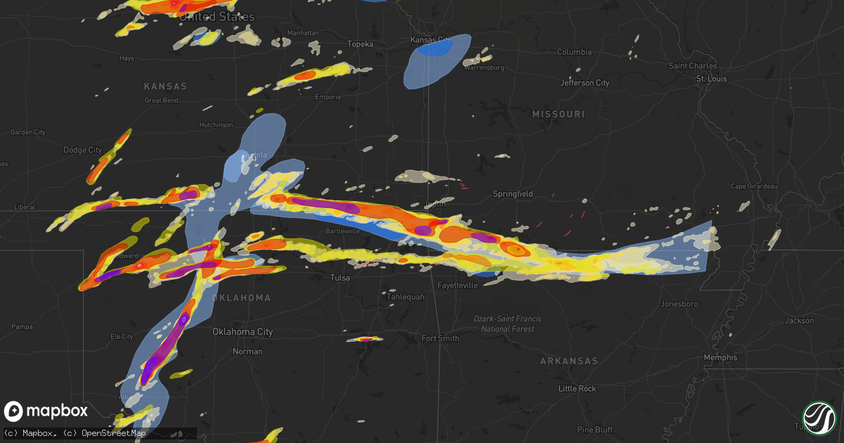
Hail Map on May 25, 2024
Get this storm
May 25 map
$229
one time, instant access
Download today. No call, no setup
Keep the $229
Bought the map and want the full workflow? Apply the entire $229 to a subscription within 7 days. None of it is wasted.
Every map, not just this one
This buys you this map. Subscription and you get every map we run, in the markets you choose from a few cities to whole states to nationwide. Plus real-time alerts the moment a storm fires.
Contact data
Name, contact info, occupancy, even credit band for addresses in the footprint. You go from where it hit to who to call.
Become the source they trust
Unlimited branding weather history reports on demand. You already have the documented answer ready for the property owner, and you are the one who showed up with it.
Property data and RoofTrace estimates
Pull up any address you have got, its value and the exact code rules for that jurisdiction, straight from One Click Code. Then RoofTrace estimates the squares, pitch, and roof value, priced the way you price.
States Impacted by Hail Map on May 25, 2024
Storm reports
Alabama
| Date | Description |
|---|---|
| 05/25/20245:40 PM CDT | Quarter size hail in pic from broadcast media. |
| 05/25/20242:40 PM CDT | A fallen tree caused a power outage to 310 alabama power customers. |
| 05/25/20242:30 PM CDT | Quarter sized hail reported from a trained spotter southwest of ozark... Al near hooper stage field. |
| 05/25/20242:28 PM CDT | Powerline down at 406 ben street. |
| 05/25/20242:20 PM CDT | Trees down on cr11 off of 231. |
| 05/25/20242:20 PM CDT | Trees and powerlines down at 3481 west cr 36. |
| 05/25/20242:09 PM CDT | Trees down on cr138. |
| 05/25/20242:07 PM CDT | Trees down on cr117. |
| 05/25/20242:01 PM CDT | Trees down on cr121. |
| 05/25/20242:00 PM CDT | Trees down on cr107. |
| 05/25/202412:40 PM CDT | Several trees and power lines down along highway 94 near dublin and on centerpoint rd southeast of dublin. |
| 05/25/202411:23 AM CDT | A tree was blown down and blocking cr 9. |
Nebraska
| Date | Description |
|---|---|
| 05/24/202411:47 PM CDT | Estimated 70 mph gusts near 72nd and center. Power out. |
| 05/24/202411:40 PM CDT | Asos station koma omaha eppley airfield. |
| 05/24/202411:30 PM CDT | Delayed report: several 1-3 inch tree limbs down in neighborhood. |
| 05/24/202410:41 PM CDT | A local report indicates 1.00 inch wind near Pawnee City |
Missouri
| Date | Description |
|---|---|
| 05/25/20246:50 AM CDT | A local report indicates 60 MPH wind near 1 S Poplar Bluff |
| 05/25/20246:47 AM CDT | Tree down on a house and a car. Cr 468 in poplar bluff. Many trees and lines down. |
| 05/25/20246:45 AM CDT | A local report indicates 60 MPH wind near 2 NNW Neelyville |
| 05/25/20246:44 AM CDT | Multiple trees and powerlines down. Several very large uprooted tress. Roof off a building. |
| 05/25/20246:42 AM CDT | Telephone poles snapped... Large limbs down... Structural damage to storage barns. |
| 05/25/20246:41 AM CDT | Home damage reported and multiple trees down in the fairdealing/harviell area. Possible tornado. |
| 05/25/20246:41 AM CDT | Home damage reported and multiple trees down in the fairdealing/harviell area. Possible tornado. |
| 05/25/20246:40 AM CDT | Corrects previous tstm wnd dmg report from 4 nw harviell. Shed destroyed. Possible tornado. Time was adjusted based on radar. |
| 05/25/20246:40 AM CDT | Reports of trees down south of doniphan and power lines down in portions of ripley county. |
| 05/25/20246:36 AM CDT | Report of roof blown off of home in naylor mo. |
| 05/25/20246:15 AM CDT | Corrects previous tornado report from 4 s gatewood. Ef-2 tornado... 115 mph. 38.6 mile track. |
| 05/25/20246:08 AM CDT | A local report indicates 1.00 inch wind near 1 ENE Thayer |
| 05/25/20246:07 AM CDT | Delayed report. Significant tree damage with several barns damaged near highway uu. Possible tornado. |
| 05/25/20246:06 AM CDT | Reports of trees down in southern iron co near reynolds co. Location and time approximate from radar. |
| 05/25/20246:05 AM CDT | Delayed report two large trees blown down on highway p west of alton. |
| 05/25/20246:04 AM CDT | Trees down over hwy 49 near black mo with report of car wreck due to downed tree. Time estimate from radar. |
| 05/25/20245:45 AM CDT | Multiple trees down across hwy 21. Location and time estimate from radar. |
| 05/25/20244:22 AM CDT | A local report indicates 2.75 inch wind near 1 N Lebanon |
| 05/25/20244:20 AM CDT | A local report indicates 1.00 inch wind near 3 N Ridgedale |
| 05/25/20244:20 AM CDT | Numerous trees down with some twisted. Possibly associated with the 4 ene willhoit lsr tor. |
| 05/25/20244:20 AM CDT | Radar confirmed tds. |
| 05/25/20244:19 AM CDT | Nws storm survey concluded an ef0 tornado with peak winds around 80 mph started over the caney mountain conservation area east of willhoit and travelled northeast for a |
| 05/25/20244:15 AM CDT | Report from mping... Hen egg+ 2.25 in. Time based on radar. |
| 05/25/20244:15 AM CDT | Report from mping... Quarter 1.00 in. Time based on radar. |
| 05/25/20244:15 AM CDT | Report from mping... Golf ball 1.75 in. |
| 05/25/20244:15 AM CDT | Report from mping... Quarter 1.00 in. |
| 05/25/20244:14 AM CDT | Report from mping... Quarter 1.00 in. |
| 05/25/20244:14 AM CDT | A local report indicates 1.75 inch wind near Blue Eye |
| 05/25/20244:12 AM CDT | Telephone poles and trees down... East side of ash grove. Time based on radar estimate. |
| 05/25/20244:12 AM CDT | 1/2 to 1 hail at my location... West side of branson. |
| 05/25/20244:12 AM CDT | Report from mping... Quarter 1.00 in. Time based on radar estimate. |
| 05/25/20244:12 AM CDT | Corrects previous tstm wnd dmg report from ash grove. Telephone poles and trees down... East side of ash grove. Time based on radar estimate. |
| 05/25/20244:11 AM CDT | A brief ef0 tornado touched down 5 miles southwest of buffalo. Maximum wind speeds of 65 mph with a width of 100 yards. Numerous large branches broken and a few trees s |
| 05/25/20244:06 AM CDT | Report of a tree across the road 95 just north of 14 eastern douglas county. Time based on radar estimate. |
| 05/25/20244:06 AM CDT | A local report indicates 1.00 inch wind near Kimberling City |
| 05/25/20244:05 AM CDT | Report from mping... Golf ball 1.75 in. |
| 05/25/20244:00 AM CDT | A local report indicates 1.50 inch wind near 1 NE Lampe |
| 05/25/20243:54 AM CDT | Report from mping... Quarter 1.00 in. Time based on radar. |
| 05/25/20243:54 AM CDT | 2 rounds of hail at my home in shell knob on the barry/stone line. First was small... Most around pea to marble size... Second was much larger... Well over quarter size |
| 05/25/20243:54 AM CDT | Vis social media. Time based on radar estimated. |
| 05/25/20243:54 AM CDT | Report from mping: golf ball |
| 05/25/20243:54 AM CDT | Delayed report of two full size trees down at lake house near shell knob. |
| 05/25/20243:48 AM CDT | Via social media. |
| 05/25/20243:48 AM CDT | Numerous trees down with some tops off of others. Power outage. |
| 05/25/20243:44 AM CDT | Radar confirmed tds. |
| 05/25/20243:42 AM CDT | Power-lines and trees down. Structures damaged. Possible tor. Time based on radar estimate. 2955 hwy f area. |
| 05/25/20243:39 AM CDT | Early sunday morning... An nws storm survey confirmed an ef 1 tornado touched down 6 miles northwest of mansfield in a hilly wooded area near highway f and quickly inte |
| 05/25/20243:38 AM CDT | Power poles and trees down in butterfield in barry county. Time based on radar estimate. |
| 05/25/20243:38 AM CDT | Power poles and trees down west of cassville and butterfield in barry county. Time based on radar estimate. |
| 05/25/20243:38 AM CDT | Delayed report. Power poles and trees down west of cassville and butterfield in barry county. Time based on radar estimate. |
| 05/25/20243:36 AM CDT | Via social media pictures of large trees down. Time based on radar estimate. |
| 05/25/20243:36 AM CDT | Corrects previous tstm wnd dmg report from 3 sse cassville to 5 wnw eagle rock. Via social media pictures of large trees down. Time based on radar estimate. |
| 05/25/20243:35 AM CDT | Report from mping... 3-inch tree limbs broken; power poles broken. Time based on radar estimate. |
| 05/25/20243:35 AM CDT | Report from mping... 3-inch tree limbs broken; power poles broken. Time based on radar. |
| 05/25/20243:33 AM CDT | Radar confirmed tds just northeast of bradleyville. Continued northeast into douglas county. |
| 05/25/20243:33 AM CDT | Nws storm survey found an ef-0 tornado with maximum winds of 85mph in southwest dade county. Damage to trees and a barn occurred. An irrigation system was also flipped. |
| 05/25/20243:32 AM CDT | Early sunday morning... An ef0 tornado crossed highway 125 1 mile north of bradleyville... Downing tree branches... Then uprooting trees east of the highway. Swirl mark |
| 05/25/20243:31 AM CDT | Powerlines down in wheaton. |
| 05/25/20243:30 AM CDT | Report from mping... 1-inch tree limbs broken; shingles blown off. Time based on radar. |
| 05/25/20243:30 AM CDT | Corrects previous hail report from 3 sse cassville to 5 wnw eagle rock. Via social media picture. Stated e70 mph winds. |
| 05/25/20243:30 AM CDT | Several trees and limbs down in wheaton per le. Time based on radar. |
| 05/25/20243:30 AM CDT | Via social media picture. Stated e70 mph winds. |
| 05/25/20243:30 AM CDT | Report from mping: quarter |
| 05/25/20243:27 AM CDT | Report from mping... Trees uprooted or snapped; roof blown off. Time based on radar. |
| 05/25/20243:25 AM CDT | Report from mping... 3-inch tree limbs broken; power poles broken. Time based on radar. |
| 05/25/20243:24 AM CDT | Just north of stella. |
| 05/25/20243:15 AM CDT | Report from mping: trees uprooted or snapped; roof blown off. Time based on radar. |
| 05/25/20243:10 AM CDT | Report from mping... Quarter 1.00 in. |
| 05/25/20243:03 AM CDT | Report from mping: quarter |
| 05/25/20243:00 AM CDT | Large tree took out several power lines in seneca mo off rhonda/grand ave. Time based on radar. |
| 05/25/20242:59 AM CDT | Golf ball hail 6 miles west of neosho. |
| 05/25/20242:58 AM CDT | Report from mping: hen egg |
| 05/25/20242:58 AM CDT | Report from mping: quarter |
| 05/25/20242:55 AM CDT | Roof blown off in seneca at highway 43. Time estimated radar. |
| 05/25/20242:53 AM CDT | Golf ball hail in neosho on highway 86. |
| 05/25/20241:32 AM CDT | Report of large tree over roadway along palis nichols drive near webster drive. Time estimated from radar. |
| 05/25/20241:28 AM CDT | Corrects previous tstm wnd dmg report from 2 wsw ashland. Report of large tree over roadway along palis nichols drive near webster drive. Time estimated from radar. |
| 05/25/202412:43 AM CDT | Large tree uprooted. Time estimated from radar. |
| 05/25/202412:25 AM CDT | Trees down... Including tree branch on a powerline. Time estimated by radar. |
| 05/25/202412:23 AM CDT | Tree limbs blown down. Time estimated from radar. |
| 05/25/202412:20 AM CDT | Law enforcement reports flying road signs. |
| 05/24/202411:48 PM CDT | Tree blown down. Time estimated from radar. |
| 05/24/202411:22 PM CDT | Mping report of 3 inch tree limbs broken; power poles broken in bates city. |
| 05/24/202411:20 PM CDT | Several large tree branches down reported by the mayor. |
| 05/24/202411:20 PM CDT | Large tree snapped in half near ward and 65th. Time estimated from radar. |
| 05/24/202411:18 PM CDT | Measured gust of 80 mph with large oak trees downed just southwest of downtown independence. |
| 05/24/202411:17 PM CDT | Large trees snapped on truman road north of grain valley. |
| 05/24/202411:15 PM CDT | Three large branches... At least 1 foot in diameter... Down near 97th and wornall. |
| 05/24/202411:15 PM CDT | Delayed mping report of trees snapped or uprooted in raytown. Time estimated from radar. |
| 05/24/202411:15 PM CDT | Peak gust of 81 mph measured from personal weather station just north of independence center. |
| 05/24/202411:11 PM CDT | Power lines downed in blue springs. Power is out. |
| 05/24/202411:10 PM CDT | A local report indicates 74 MPH wind near 2 ENE Unity Village |
| 05/24/202411:10 PM CDT | Mping report of 3 inch tree limbs broken; power poles broken near the grandview triangle. |
| 05/24/202411:09 PM CDT | Delayed report of large tree limbs... A large wooden utility pole... And power lines downed across missouri route 150 just west of the intersection with missouri route |
| 05/24/202411:07 PM CDT | Estimated 60 mph wind gusts at wfo pleasant hill. |
| 05/24/202411:07 PM CDT | Between visual estimation and measured gust from an automated weather station on site... Estimated 65 to 70 mph wind gusts at wfo pleasant hill. |
| 05/24/202411:05 PM CDT | Large tree uprooted near douglas and elm. Another large tree blocking traffic at douglas and orchard. Time estimated from radar. |
| 05/24/202411:05 PM CDT | Large tree branches down. |
| 05/24/202411:03 PM CDT | Large tree branches down. Time estimated via radar. |
| 05/24/202411:00 PM CDT | Large oak tree limb snapped on the west side of raintree lake. |
| 05/24/202410:53 PM CDT | Tree down at foxwood dr and park dr in raymore. |
| 05/24/202410:52 PM CDT | Tree down near lucy webb rd and silvertop ln in raymore. |
| 05/24/202410:49 PM CDT | Large tree over roadway at 203rd st and peculiar dr. |
Kentucky
| Date | Description |
|---|---|
| 05/25/20242:33 AM CDT | Trees were reported to have been blown down. The event time is radar estimated. |
South Carolina
| Date | Description |
|---|---|
| 05/25/20245:57 PM CDT | Spotter reported large trees down and a pecan tree uprooted. Power l |
| 05/25/20245:57 PM CDT | Spotter reported large trees down and a pecan tree uprooted. Power lines down. |
| 05/25/20242:25 PM CDT | Amateur radio operator relayed tree down on house on heather drive in west florence per fire north. |
| 05/25/20242:15 PM CDT | Amateur radio operator relayed tree down on house on heather drive in west florence per fire north. |
| 05/25/202412:35 PM CDT | *** 1 inj *** mccormick county officials reported a collision between vehicle and downed tree in roadway along chestnut ridge road north of mccormick. Driver was taken |
| 05/25/202412:25 PM CDT | Mccormick county officials reported 1 tree on a house and 17 trees down across the savannah lakes subdivision roadways. Time estimated by radar. |
| 05/24/20247:38 PM CDT | Berkeley county emergency management reported a couple of trees down near 2400 n hw-17a. |
| 05/24/20247:38 PM CDT | Berkeley county emergency management reported a tree down near the intersection of edith lane and church of god road. |
| 05/24/20247:36 PM CDT | Two trees reported down along betsy hole road. |
| 05/24/20247:35 PM CDT | Berkeley county emergency management reported a tree down and power lines down near the intersection of barnyard road and full house lane. |
| 05/24/20247:35 PM CDT | Roof and building damage to macedonia middle school and macedonia high school. |
| 05/24/20247:34 PM CDT | Emergency manager reported around 30 trees and 2 power lines down between bonneau and jamestown north of highway 17. |
| 05/24/20247:33 PM CDT | Tree reported down on house. |
| 05/24/20247:30 PM CDT | Berkeley county emergency management reported a tree down in the area of 1800 e church street. |
Mississippi
| Date | Description |
|---|---|
| 05/25/20244:57 PM CDT | A local report indicates 1.00 inch wind near Bigbee Valley |
| 05/25/20244:45 PM CDT | Home sustained roof damage off hwy 388. |
| 05/25/20244:08 PM CDT | Corrects time of previous tstm wnd dmg report from 2 w macon. Several trees and power lines were blown down along gillis road west of macon... And in town several power |
| 05/25/20243:13 PM CDT | Hail chipped a windshield along ms 15 south of noxapater. |
| 05/24/20248:08 PM CDT | Several trees and power lines were blown down along gillis road west of macon... And in town several power outages were reported from downed trees or branches. |
Arkansas
| Date | Description |
|---|---|
| 05/25/20246:36 AM CDT | Large tree down in corning... Blocking a road. Time is radar estimated. |
| 05/25/20246:30 AM CDT | Trees down. |
| 05/25/20246:28 AM CDT | Nws damage survey team has found damage associated with a short track ef-1 tornado that occurred early sunday morning in randolph county. Significant roof loss and othe |
| 05/25/20246:21 AM CDT | Report of multiple roads blocked due to downed trees and power lines. |
| 05/25/20246:20 AM CDT | Nws damage survey team has found damage associated with another ef-1 tornado that occurred early sunday morning in randolph county... South and east of attica. Numerous |
| 05/25/20246:00 AM CDT | **this is a delayed report** mesonet station fw0859 ash flat. |
| 05/25/20246:00 AM CDT | Nws damage survey team has found damage associated with an short lived ef-1 tornado that occurred early sunday morning in sharp county... Just north of williford. A num |
| 05/25/20245:53 AM CDT | Measured at sharp county regional airport. |
| 05/25/20245:08 AM CDT | Nws damage survey has found damage associated with a short track ef-1 tornado that occurred early sunday morning in fulton county. Numerous trees were downed along the |
| 05/25/20244:48 AM CDT | House reported to be damaged on starkey road. This was a radar confirmed tornado at time of report. |
| 05/25/20244:31 AM CDT | Multiple roads in county blocked due to downed trees and power lines. Time estimated by radar observations. |
| 05/25/20244:26 AM CDT | Trees reported down and roof damage reported to homes. Report related by ky3. |
| 05/25/20244:25 AM CDT | Nws damage survey team has preliminarily found low-end ef-3 damage associated with a tornado that occurred early sunday morning in baxter county. Since the team is stil |
| 05/25/20244:19 AM CDT | A local report indicates 2.50 inch wind near Omaha |
| 05/25/20244:07 AM CDT | Trees damaged by thunderstorm wind gust. |
| 05/25/20243:47 AM CDT | Multiple trees and power lines downed. This was a radar confirmed tornado at time of report. |
| 05/25/20243:33 AM CDT | *** 1 fatal *** updated and corrected previously issued tornado report from 1 ssw olvey. House reported to be damaged on starkey road. This was a radar confirmed tornad |
| 05/25/20243:33 AM CDT | Corrects previous tornado report from 1 ssw olvey. House reported to be damaged on starkey road. This was a radar confirmed tornado at time of report. |
| 05/25/20243:33 AM CDT | Corrects previous tornado report from 1 sw olvey. Nws damage survey crew has preliminarily found low-end ef-3 damage associated with a tornado that occurred early this |
| 05/25/20242:53 AM CDT | Report from mping: quarter |
| 05/25/20242:31 AM CDT | A local report indicates 1.00 inch wind near 4 SW Grandview |
| 05/25/20241:52 AM CDT | Reports of damage in rogers...possible tornado. |
| 05/25/20241:52 AM CDT | A local report indicates 62 MPH wind near 3 NNE Rogers |
| 05/25/20241:47 AM CDT | Report from mping: quarter |
| 05/25/20241:47 AM CDT | Extensive tree damage. Multiple trees down. Large tree limb penetrated home. Near intersection of ridgefield and robson way. |
| 05/25/20241:47 AM CDT | Large trees down. |
| 05/25/20241:47 AM CDT | Report from mping: quarter as closed from 2nd street to lost lane in gypsum due to a fallen tree. The road was closed for 40 minutes. |
| 05/25/20241:41 AM CDT | A local report indicates 1.00 inch wind near 2 N Bella Vista |
| 05/25/20241:36 AM CDT | Report from mping: quarter |
| 05/25/20241:15 AM CDT | Anticyclonic tornado with tds on radar. |
| 05/25/20241:10 AM CDT | Tds on radar. |
West Virginia
| Date | Description |
|---|---|
| 05/25/20246:19 PM CDT | Tree down blocking road along berry hollow rd and mason-dixon highway |
| 05/24/202410:51 PM CDT | Tree down on north main st. |
| 05/24/202410:45 PM CDT | Corrects previous tstm wnd dmg report from philippi. Tree down on north main st. Time estimated from radar. |
| 05/24/202410:30 PM CDT | Tree down near intersection of route 119 and upper pleasant creek rd. Time estimated from radar. |
| 05/24/202410:30 PM CDT | Tree down on mcvicker rd. Time estimated from radar. |
| 05/24/202410:30 PM CDT | Tree down reported on simpson road near flemington. |
| 05/24/202410:25 PM CDT | Tree down on lost run rd. Time estimated from radar. |
| 05/24/202410:25 PM CDT | Tree down on webster pike. Time estimated from radar. |
| 05/24/202410:20 PM CDT | Tree down on west olive st. Time estimated from radar. |
| 05/24/202410:20 PM CDT | Tree down on benedum drive. Time estimated from radar. |
| 05/24/202410:00 PM CDT | Tree down reported on pine bluff road. |
Pennsylvania
| Date | Description |
|---|---|
| 05/25/20246:11 PM CDT | Tree down on nilan rd |
| 05/25/20246:05 PM CDT | Tree down on sr 166 |
| 05/25/20245:38 PM CDT | Tree down across laird road just west of lake road. |
| 05/25/20245:14 PM CDT | Large branches down on state route 837 at coal bluff road... Blocking the road. Time estimated. |
| 05/25/20244:47 PM CDT | A local report indicates 1.50 inch wind near Hickman |
| 05/25/20244:45 PM CDT | A local report indicates 1.50 inch wind near Rennerdale |
| 05/25/20244:45 PM CDT | Large branches down on route 980... Blocking road. Time estimated from radar. |
| 05/25/20244:41 PM CDT | Picture provided of golf ball hail |
| 05/25/20244:40 PM CDT | A local report indicates 1.00 inch wind near 2 SW Coraopolis |
| 05/25/20244:40 PM CDT | A local report indicates 1.50 inch wind near 3 SSW Coraopolis |
| 05/25/20244:38 PM CDT | Observed along coventry drive |
| 05/25/20244:38 PM CDT | Observed along coventry drive |
| 05/25/20244:37 PM CDT | A local report indicates 1.50 inch wind near Avalon |
| 05/25/20244:37 PM CDT | A local report indicates 1.00 inch wind near N Oakdale |
| 05/25/20244:36 PM CDT | A local report indicates 1.75 inch wind near 1 W Robinson Township |
| 05/25/20244:35 PM CDT | Along prism pl |
| 05/25/20244:34 PM CDT | A local report indicates 1.00 inch wind near 2 E Imperial-Enlow |
| 05/25/20244:34 PM CDT | Golf ball sized hail at the imperial vfd |
| 05/25/20244:33 PM CDT | Penny to half-dollar sized hail |
| 05/25/20244:32 PM CDT | Delayed report - hail measured over 2 inches. |
| 05/25/20244:26 PM CDT | A local report indicates 1.00 inch wind near 1 ENE Clinton |
| 05/25/20244:10 PM CDT | Trees down on mahoning road and university drive. Time estimated from radar. |
| 05/25/20244:03 PM CDT | Tree down on mountain road. Time estimated from radar. |
| 05/25/20244:02 PM CDT | Tree and wires down on rich hill road.... |
| 05/25/20244:00 PM CDT | Trees down along dunbar ohiopyle rd |
| 05/25/20243:59 PM CDT | Tree and wires down on pleasant hill road. Possible tornado damage. |
| 05/25/20243:59 PM CDT | Trees and wires down on pleasant hills road. Damage connected to a brief ef-0 tornado. |
| 05/25/20243:50 PM CDT | Tree down on route 130. Time estimated from radar. |
| 05/25/20243:15 PM CDT | Large branches down on at the 3300 block of vista valley road... Blocking the road. Time estimated. |
| 05/25/20243:00 PM CDT | Tree down on tunnelton road. Time estimated from radar. |
| 05/25/20242:40 PM CDT | Trees down at the intersection of dark hollow road and plum street. Time estimated from radar. |
| 05/25/20242:30 PM CDT | Tree and wires down on ekastown road. Time estimated from radar. |
| 05/25/20242:28 PM CDT | Trees down on cedar run road. Time estimated from radar. |
| 05/25/20242:17 PM CDT | Tree down on rodi road. Time estimated from radar. |
| 05/25/20242:13 PM CDT | Large branches down along oakdale rd just south of us-22 |
| 05/25/20242:10 PM CDT | Trees down at the intersection of sherwodd and morrow roads. Time estimated from radar. |
| 05/25/20242:03 PM CDT | Utility poles and traffic lights down on route 65 |
| 05/25/20242:02 PM CDT | Report from mping: 1-inch tree limbs broken |
| 05/25/20241:55 PM CDT | Tops of trees broken off |
| 05/25/20241:42 PM CDT | Trees down on river road |
| 05/25/20241:40 PM CDT | Trees and wires down in center township |
| 05/25/20241:36 PM CDT | Report from mping: 1-inch tree limbs broken jackson mo 3898 9448 delayed mping report of trees snapped or uprooted in raytown. Time estimated f |
| 05/25/20241:36 PM CDT | Report from mping: 1-inch tree limbs broken |
| 05/25/20241:36 PM CDT | Report from mping: 1-inch tree limbs broken |
| 05/25/20241:34 PM CDT | Trees down on river road |
| 05/25/202412:50 PM CDT | Wires down |
| 05/25/202412:50 PM CDT | Wires down |
| 05/25/202412:02 PM CDT | Down trees |
Maryland
| Date | Description |
|---|---|
| 05/25/20246:08 PM CDT | Two trees were reported down and blocking the road on fountain head rd near gordon circle. |
| 05/25/20245:41 PM CDT | Numerous trees down in and around clear spring... Md. |
Iowa
| Date | Description |
|---|---|
| 05/25/20247:57 AM CDT | Part of the roof of a farm outbuilding torn off. Possible tornado. |
| 05/25/20241:28 AM CDT | Submitted photo of quarter sized hail in lytton. |
| 05/24/202411:45 PM CDT | A local report indicates 62 MPH wind near 4 WSW Mcclelland |
Texas
| Date | Description |
|---|---|
| 05/25/20246:45 PM CDT | Report of ping pong ball size hail se of gorman. |
| 05/25/20245:47 PM CDT | Tornado reported by trained spotter 6 w of rising star. |
| 05/25/20245:42 PM CDT | Law enforcement reported a brief tornado touching down right on the callahan/eastland county line. |
| 05/25/20245:37 PM CDT | A local report indicates a tornado near 5 WSW Bluegrove |
| 05/25/20245:16 PM CDT | Tornado observed near windthorst... Starting at 516 pm and lasting until approximately 525pm. |
| 05/25/20245:12 PM CDT | Report from mping: quarter . |
| 05/25/20245:12 PM CDT | Report from mping: quarter |
| 05/25/20245:06 PM CDT | A local report indicates 2.50 inch wind near 10 W Cross Plains |
| 05/25/20245:02 PM CDT | Time estimated based on radar. |
| 05/25/20244:52 PM CDT | Photo of tennis ball hail 10 e of cross plains shared on social media. |
| 05/25/20244:40 PM CDT | Coleman co. Dispatch reported in tennis to golf ball size hail along the coleman-callahan county line on 206. |
| 05/25/20243:50 PM CDT | Hen egg to tennis ball sized hail falling near lawn. |
| 05/25/20243:48 PM CDT | Tornado on ground reported by trained spotter on fm1770 and fm382 looking north 1 to 2 miles. Visible dirt and dust kicking up from the base. |
| 05/25/20243:44 PM CDT | A local report indicates 1.75 inch wind near Lawn |
| 05/25/20243:44 PM CDT | Ne. |
| 05/25/20243:43 PM CDT | Taylor co. Sheriff called to report a tornado on the ground south of lawn just north of the runnels county line. |
| 05/25/20243:20 PM CDT | A local report indicates 1.00 inch wind near 5 SE Seymour |
| 05/25/20242:32 PM CDT | A local report indicates 72 MPH wind near Blackwell |
| 05/25/20242:12 PM CDT | Report from mping: hen egg |
| 05/25/202411:40 AM CDT | Delayed report quarter-size hail reported just south of van alstyne. |
| 05/25/20245:04 AM CDT | Multiple trees blown over or snapped. |
| 05/25/20244:33 AM CDT | So reports golf ball size hail in eden. Time estimated via radar. |
| 05/25/20243:30 AM CDT | Report of quarter size hail via social media. Time estimated from radar. |
| 05/25/20243:21 AM CDT | A local report indicates 1.00 inch wind near Mertzon |
| 05/25/20241:45 AM CDT | Delayed report. Several reports of wind damage in the carlsbad area... Including large tree limbs and small trees knocked down. |
| 05/25/20241:40 AM CDT | Delayed report. Several reports of wind damage in the water valley area... Including large tree limbs... Small trees knocked down... Property damage and metal sheets to |
| 05/25/20241:05 AM CDT | Quarter size hail falling in sterling city. |
| 05/24/202411:36 PM CDT | Delayed report mping report of ping pong sized hail on the south side of sherman. |
| 05/24/202411:34 PM CDT | Report from mping: quarter |
| 05/24/202411:22 PM CDT | Delayed report received multiple reports of a tornado crossing hwy 289 north of celina with reports of residential damage near hwy 289 and cr 100. More structural damag |
| 05/24/202411:20 PM CDT | Report from mping: quarter |
| 05/24/202411:04 PM CDT | Report of measured 70 mph wind gust at near bus 377 and fm 377. Time estimated via radar. |
| 05/24/202410:50 PM CDT | Delayed report golf ball sized hail reported north of valley view. |
| 05/24/202410:44 PM CDT | Received multiple reports of tornado damage from spotters and social media near lone oak rd and i35 in between valley view and sanger near the cooke and denton county l |
| 05/24/202410:40 PM CDT | Downer power lines east of sanger. |
| 05/24/202410:40 PM CDT | Delayed report 3 inch hail reported in mountain springs... East of valley view. |
| 05/24/202410:34 PM CDT | Report of moderate amount of nickel to quarter sized hail in era. |
| 05/24/202410:22 PM CDT | Measured 70 mph wind gust off of fm 922 near rosston tower. |
| 05/24/202410:00 PM CDT | Delayed report half-dollar sized hail reported 2 miles north of forestburg in montague county. |
| 05/24/20249:55 PM CDT | Delayed report received several reports of tornado damage south of forestburg in southeast montague county toward rosston in southwest cooke county. Significant tree da |
| 05/24/20249:37 PM CDT | Union pacific track inspector encountered a large tree down across the tracks approximately 3 miles south of bowie... Tx. Time estimated via radar. |
| 05/24/20249:10 PM CDT | Ping pong ball size hail at jordan and brush road southeast of bowie. |
| 05/24/20248:39 PM CDT | Ping pong ball size hail at cole and 101 south of bowie. |
Oklahoma
| Date | Description |
|---|---|
| 05/25/20246:59 PM CDT | Via nwschat. |
| 05/25/20246:57 PM CDT | Via nwschat. |
| 05/25/20246:57 PM CDT | Photo via nwschat; time estimated based on radar. |
| 05/25/20246:56 PM CDT | Delayed report of baseball sized hail near the intersection of boomer and keowee road. |
| 05/25/20246:51 PM CDT | Via nwschat. |
| 05/25/20246:50 PM CDT | Twitter photo; time estimated based on radar. |
| 05/25/20246:50 PM CDT | Twitter photo; time estimated based on radar. |
| 05/25/20246:50 PM CDT | Via nwschat; south end of enid. |
| 05/25/20246:48 PM CDT | Via nwschat. |
| 05/25/20246:45 PM CDT | Twitter photo; time and location estimated based on radar. |
| 05/25/20246:45 PM CDT | A local report indicates 61 MPH wind near 1 WSW Lahoma |
| 05/25/20246:45 PM CDT | Twitter photo; time and location estimated based on radar. |
| 05/25/20246:45 PM CDT | Ron. |
| 05/25/20246:44 PM CDT | Report from mping. |
| 05/25/20246:44 PM CDT | Report from mping. . |
| 05/25/20246:38 PM CDT | Via nwschat; time estimated based on radar. |
| 05/25/20246:29 PM CDT | Tornado observed beginning at 629 pm approximately 3 miles north of chester. |
| 05/25/20246:23 PM CDT | Report from mping; time estimated based on radar. |
| 05/25/20246:19 PM CDT | A local report indicates 1.00 inch wind near 3 N Chester |
| 05/25/20246:14 PM CDT | Time estimated from radar. |
| 05/25/20246:14 PM CDT | Tornado observed approximately from 614 pm to 620 pm. |
| 05/25/20246:13 PM CDT | A local report indicates 2.50 inch wind near 2 NE Mutual |
| 05/25/20245:55 PM CDT | Social media; time estimated based on radar. |
| 05/25/20245:52 PM CDT | Report from mping; time estimated based on radar. |
| 05/25/20245:49 PM CDT | Report from mping; time estimated based on radar. |
| 05/25/20245:44 PM CDT | Report from mping. |
| 05/25/20245:42 PM CDT | Report from mping. |
| 05/25/20245:40 PM CDT | Time estimated based on radar. |
| 05/25/20245:35 PM CDT | Report from mping. |
| 05/25/20245:35 PM CDT | Photo on twitter; location and time estimated based on radar. |
| 05/25/20245:35 PM CDT | A local report indicates 3.50 inch wind near 6 ENE Arnett |
| 05/25/20245:27 PM CDT | Time estimated based on radar. |
| 05/25/20245:25 PM CDT | A local report indicates 2.50 inch wind near 4 SE Hydro |
| 05/25/20245:25 PM CDT | Report from mping; time estimated based on radar. |
| 05/25/20245:25 PM CDT | A local report indicates 63 MPH wind near 4 WSW Weatherford |
| 05/25/20245:21 PM CDT | Report from mping; time estimated based on radar. |
| 05/25/20245:15 PM CDT | Time estimated based on radar. |
| 05/25/20245:12 PM CDT | Report on hwy 54... 10 miles south of weatherford; time estimated based on radar. |
| 05/25/20245:12 PM CDT | Report on hwy 54... 10 miles south of weatherford; time estimated based on radar. |
| 05/25/20244:58 PM CDT | Spotter reported between rocky and 152... North of mountain view. Location estimated based on radar. |
| 05/25/20244:50 PM CDT | Time estimated based on radar. |
| 05/25/20244:47 PM CDT | Report from mping; time estimated based on radar. |
| 05/25/20244:47 PM CDT | Time estimated based on radar. |
| 05/25/20244:42 PM CDT | Time estimated based on radar. |
| 05/25/20244:39 PM CDT | A local report indicates 66 MPH wind near 3 SE Hobart |
| 05/25/20244:28 PM CDT | A local report indicates 2.50 inch wind near Roosevelt |
| 05/25/20244:25 PM CDT | A local report indicates 2.75 inch wind near Roosevelt |
| 05/25/20244:25 PM CDT | Report from mping. Time estimated based on radar. |
| 05/25/20244:20 PM CDT | A local report indicates 58 MPH wind near 4 S Tipton |
| 05/25/20244:07 PM CDT | Tornado from about 407 pm to 410 pm. The tillman county emergency manager reports damage to a barn. |
| 05/25/20244:05 PM CDT | Shingles blow off room. 1-inch tree limbs broken. |
| 05/25/20244:00 PM CDT | A local report indicates 59 MPH wind near 3 S Altus |
| 05/25/20242:54 AM CDT | A local report indicates 2.00 inch wind near 5 NW Tiff City |
| 05/25/20242:42 AM CDT | A local report indicates 1.75 inch wind near Fairland |
| 05/25/20242:30 AM CDT | Report from mping: quarter |
| 05/25/20242:26 AM CDT | Report from mping: golf ball |
| 05/25/20241:27 AM CDT | A local report indicates 1.00 inch wind near 1 NE Mazie |
| 05/25/20241:21 AM CDT | A local report indicates 1.75 inch wind near 4 NNW Hulah |
| 05/25/20241:10 AM CDT | Trees damaged by thunderstorm wind gusts. |
| 05/25/20241:06 AM CDT | A local report indicates 2.00 inch wind near 3 SE Onapa |
| 05/25/202412:52 AM CDT | A local report indicates 1.00 inch wind near 3 SW Onapa |
| 05/25/202412:26 AM CDT | Power poles down and building damage relayed from broadcast media. |
| 05/24/202411:36 PM CDT | Koa campground east of claremore struck by a likely tornado |
| 05/24/202411:28 PM CDT | Tds on radar... Numerous reports of damage in claremore. |
| 05/24/202411:20 PM CDT | Report from mping: 1-inch tree limbs broken; shingles blown off. |
| 05/24/202411:06 PM CDT | Report from mping: quarter |
| 05/24/20249:44 PM CDT | Golf ball sized hail along us177 on the kay/noble county line. |
| 05/24/20249:27 PM CDT | Hal dollar sized hail southeast of billings. |
| 05/24/20248:41 PM CDT | Hail a little smaller than golf balls. |
| 05/24/20248:37 PM CDT | Photo via nwschat. |
| 05/24/20247:53 PM CDT | Report from mping. |
| 05/24/20247:48 PM CDT | Photo via twitter. |
| 05/24/20247:48 PM CDT | Photo on twitter; time estimated based on radar. |
| 05/24/20247:42 PM CDT | A local report indicates 74 MPH wind near 5 SW Breckenridge |
| 05/24/20247:23 PM CDT | Via nwschat. |
| 05/24/20247:20 PM CDT | A local report indicates 58 MPH wind near 0.5 SSW Cherokee |
| 05/24/20247:16 PM CDT | A local report indicates 65 MPH wind near Drummond |
Utah
| Date | Description |
|---|---|
| 05/25/20243:04 PM CDT | Report from mping: 1-inch tree limbs broken; shingles blown off. |
| 05/25/20242:50 PM CDT | Mesonet station pc338 horse haven. |
North Carolina
| Date | Description |
|---|---|
| 05/25/20246:00 PM CDT | Tree on house in the 6000 block of nc 96. |
| 05/25/20245:28 PM CDT | Raleigh dispatch reported a tree fell on powerlines... Knocking out power. This was near the intersection of shepard school rd and rosinburg rd. |
| 05/25/20241:55 PM CDT | Public reported numerous trees blown down northeast of granite falls... Including in dudley shoals and vicinity. |
| 05/25/20246:56 AM CDT | The surry county 911 center reported that a large tree was down at the intersection of pinnacle hotel road and old pinnacle hotel road blocking both lanes of traffic. I |
Colorado
| Date | Description |
|---|---|
| 05/25/20244:08 PM CDT | Mostly marble sized. |
| 05/25/20244:08 PM CDT | Mostly marble sized hailstones. |
| 05/25/20242:35 PM CDT | Awos station k20v kremmling awos. |
| 05/25/20242:26 PM CDT | Mesonet station co092 070e171 dowd jct. |
| 05/25/20241:51 PM CDT | From eagle county alert system: eagle street was closed from 2nd street to lost lane in gypsum due to a fallen tree. The road was closed for 40 minutes. |
| 05/25/20241:42 PM CDT | Awos station kege eagle county rgnl airport. |
Kansas
| Date | Description |
|---|---|
| 05/25/20246:55 PM CDT | A local report indicates 1.50 inch wind near Medicine Lodge |
| 05/25/20246:55 PM CDT | Report was from social media with pictures. |
| 05/25/20246:30 PM CDT | Corrects time of previous hail report from 7 ne plainville. |
| 05/25/20246:20 PM CDT | A local report indicates 1.00 inch wind near 7 NE Plainville |
| 05/25/20246:17 PM CDT | A local report indicates 1.50 inch wind near Plainville |
| 05/25/20246:00 PM CDT | Mostly pea size hail or smaller. Hail was covering the ground. Did have a few hail stones as large as a half dollar. Report was from social media with pictures. |
| 05/25/20246:00 PM CDT | Report received from social media. |
| 05/25/20245:54 PM CDT | Report from mping: half dollar |
| 05/25/20245:50 PM CDT | A local report indicates 1.75 inch wind near 3 S Buttermilk |
| 05/25/20245:50 PM CDT | Report received through social media with picture. |
| 05/25/20245:30 PM CDT | Skylights were broken. Window panes were broken and window frames were dented. |
| 05/25/20245:25 PM CDT | A local report indicates 1.00 inch wind near 3 ENE Englewood |
| 05/25/20242:06 AM CDT | A local report indicates 1.50 inch wind near 2 SW Bartlett |
| 05/25/20241:54 AM CDT | Report from mping: quarter |
| 05/25/20241:34 AM CDT | Report from mping: golf ball |
| 05/25/20241:32 AM CDT | A local report indicates 2.50 inch wind near Tyro |
| 05/25/20241:19 AM CDT | A local report indicates 1.75 inch wind near 2 S Tyro |
| 05/25/20241:18 AM CDT | A local report indicates 80 MPH wind near Caney |
| 05/25/20241:13 AM CDT | A local report indicates 1.00 inch wind near 2 S Havana |
| 05/25/20241:10 AM CDT | A local report indicates 1.75 inch wind near Caney |
| 05/25/202412:00 AM CDT | Tree uprooted near 5th street and t street. |
| 05/24/202411:58 PM CDT | Asos station kwld strother field airport. |
| 05/24/202411:54 PM CDT | Knocked down trees and power lines. Delayed report. Time estimated by radar. |
| 05/24/202411:52 PM CDT | Trees and powerlines knocked down. Delayed report. Time estimated by radar. |
| 05/24/202411:40 PM CDT | A local report indicates 1.25 inch wind near 4 ESE Council Grove |
| 05/24/202411:38 PM CDT | Multiple reports of hail ranging from nickel to half dollar in size in the town of norton. |
| 05/24/202411:36 PM CDT | 60 mph wind gusts estimated in huron. |
| 05/24/202411:34 PM CDT | Relayed via kvoe radio. |
| 05/24/202411:25 PM CDT | A local report indicates 1.75 inch wind near 4 E Wilsey |
| 05/24/202411:20 PM CDT | Several trees down. |
| 05/24/202411:20 PM CDT | Tree limbs down near state line and 50th. Time estimated from radar. |
| 05/24/202411:17 PM CDT | Approximately 25 medium to large-sized tree limbs down near ward and 85th. Time estimated from radar. |
| 05/24/202411:15 PM CDT | Down trees 12 inches in diameter on the university of kansas edwards campus. |
| 05/24/202411:15 PM CDT | Powerlines down. |
| 05/24/202411:10 PM CDT | Several large trees blown on to a house near shawnee mission pkwy and antioch. Time estimated. |
| 05/24/202411:07 PM CDT | 5 inch diameter tree limb down... Estimated 60 mph wind... And power out. |
| 05/24/202411:04 PM CDT | A local report indicates 84 MPH wind near 1 NE Lenexa |
| 05/24/202411:03 PM CDT | Large tree down... Time estimated from radar. |
| 05/24/202411:00 PM CDT | A local report indicates 60 MPH wind near 2 NNW Lackmans |
| 05/24/202410:45 PM CDT | A local report indicates 68 MPH wind near 4 W Stanley |
| 05/24/202410:43 PM CDT | A local report indicates 61 MPH wind near 1 WNW Clare |
| 05/24/202410:35 PM CDT | A local report indicates 60 MPH wind near Louisburg |
| 05/24/202410:34 PM CDT | Time estimated via radar. |
| 05/24/202410:26 PM CDT | Trees knocked down. |
| 05/24/202410:22 PM CDT | A local report indicates 58 MPH wind near 3 NNE Vermillion |
| 05/24/202410:20 PM CDT | 50-60 mph wind gust and penny-sized hail reported. |
| 05/24/20249:45 PM CDT | A local report indicates 60 MPH wind near Marysville |
| 05/24/20249:39 PM CDT | Delayed report. 1-inch tree limbs broken; shingles blown off. Time estimated by radar. |
| 05/24/20249:35 PM CDT | Along highway 36 and 5th road. |
| 05/24/20249:32 PM CDT | Reported tree limbs and power lines down in the city. |
| 05/24/20249:19 PM CDT | A local report indicates 70 MPH wind near Udall |
| 05/24/20249:11 PM CDT | Trees and debris blocking sw 60th road. |
| 05/24/20249:10 PM CDT | Report from mping: quarter |
| 05/24/20249:09 PM CDT | A local report indicates 1.00 inch wind near Concordia |
| 05/24/20249:05 PM CDT | A local report indicates 60 MPH wind near Washington |
| 05/24/20248:59 PM CDT | A local report indicates 60 MPH wind near Douglass |
| 05/24/20248:57 PM CDT | A local report indicates 69 MPH wind near 4 ENE Newton |
| 05/24/20248:56 PM CDT | Also estimating 50 mph winds. time estimated from radar. |
| 05/24/20248:56 PM CDT | Also estimating 50 mph winds. |
| 05/24/20248:55 PM CDT | Corrects previous tstm wnd gst report from udall. |
| 05/24/20248:55 PM CDT | A local report indicates 62 MPH wind near Colwich |
| 05/24/20248:55 PM CDT | Golf ball size hail via social media. |
| 05/24/20248:54 PM CDT | A local report indicates 69 MPH wind near 4 ENE Newton |
| 05/24/20248:53 PM CDT | Powerlines are down in the city of halstead. |
| 05/24/20248:53 PM CDT | Power lines down reported. |
| 05/24/20248:49 PM CDT | Mulitple reports of trees down in the city. |
| 05/24/20248:40 PM CDT | L . |
| 05/24/20248:40 PM CDT | 332 report from mping... Quarter 1.00 in. |
| 05/24/20248:40 PM CDT | A local report indicates 1.25 inch wind near Cawker City |
| 05/24/20248:39 PM CDT | Estimated 60-70 mph. |
| 05/24/20248:30 PM CDT | Dispatch center reported ping pong to golf ball size hail ongoing in downs. |
| 05/24/20248:30 PM CDT | A local report indicates 59 MPH wind near Colwich |
| 05/24/20248:30 PM CDT | Report via picture on social media. |
| 05/24/20248:25 PM CDT | Powerlines are reported down. |
| 05/24/20248:24 PM CDT | A local report indicates 78 MPH wind near 1 N Goddard |
| 05/24/20248:24 PM CDT | 8 inch diameter tree snapped onto vehicles. |
| 05/24/20248:21 PM CDT | A local report indicates 72 MPH wind near 1 S Wichita Eisenhower |
| 05/24/20248:16 PM CDT | A local report indicates 1.00 inch wind near 3 SW Portis |
| 05/24/20248:15 PM CDT | Dispatch reported ping pong ball to golf ball size hail in town. |
| 05/24/20248:14 PM CDT | A local report indicates 1.00 inch wind near 4 ENE Glen Elder |
| 05/24/20248:10 PM CDT | Estimated 70-75 mph with 6-10 inch diameter tree limb down. |
| 05/24/20248:00 PM CDT | Photo on social media of hail of varying sizes compared. Largest hailstone was comparable to a quarter. |
| 05/24/20247:58 PM CDT | Trained spotter indicated a roof completely removed off of house. Power lines down as well. |
| 05/24/20247:55 PM CDT | . |
| 05/24/20247:55 PM CDT | Corrects previous hail report from cawker city. |
| 05/24/20247:50 PM CDT | Dispatcher reported ping pong ball size hail falling in town. |
| 05/24/20247:43 PM CDT | A local report indicates 60 MPH wind near 6 N Arkansas City |
| 05/24/20247:42 PM CDT | A local report indicates 74 MPH wind near 7 N Arkansas City |
| 05/24/20247:35 PM CDT | A local report indicates 1.00 inch wind near 5 S Corwin |
| 05/24/20247:32 PM CDT | Delayed report. Trees and powerlines reported down near downtown arkansas city. |
| 05/24/20247:32 PM CDT | A local report indicates 2.00 inch wind near 11 NNW Waldron |
| 05/24/20247:31 PM CDT | Delayed report of a tornado 10 miles west-southwest of anthony. The spotter observed damage. |
| 05/24/20247:27 PM CDT | A local report indicates 1.25 inch wind near 6 S Attica |
| 05/24/20247:20 PM CDT | Report of suspected tornado. |
| 05/24/20247:15 PM CDT | Ef0 tornado developed in hazelton and went ne 1 mile. |
| 05/24/20247:07 PM CDT | A local report indicates 1.75 inch wind near 2 S Medicine Lodge |
| 05/24/20247:00 PM CDT | Cocorahs observer comments noted hail up to quarter size. Time estimated from radar. |
Ohio
| Date | Description |
|---|---|
| 05/25/20242:52 PM CDT | Poles snapped and wires down along route 46 just north of columbiana with public reports of tree damage in the area too. Time estimated. |
| 05/25/20242:50 PM CDT | A local report indicates 1.00 inch wind near 1 N Columbiana |
| 05/25/20242:50 PM CDT | A local report indicates 1.00 inch wind near 1 N Columbiana |
| 05/25/20241:26 PM CDT | Downed trees blocking roads along route 46. Time estimated. Microburst signature apparent on tpit radar at this time and location. |
Florida
| Date | Description |
|---|---|
| 05/24/20247:57 PM CDT | Trained spotter reports downed trees and powerlines in the vicinity of county road 305 near elkton. |
Georgia
| Date | Description |
|---|---|
| 05/25/20243:18 PM CDT | A low hanging power line at truck level was reported along county line road. |
| 05/25/20243:15 PM CDT | Tree down on lax highway. |
| 05/25/20243:10 PM CDT | Tree down on bethlehem road. |
| 05/25/20242:38 PM CDT | Hail the size of quarters observed in the center of statesboro... Ga. |
| 05/25/20242:38 PM CDT | Hail the size of quarters observed in the center of statesboro... Ga. |
| 05/25/20242:33 PM CDT | Em reported quarter size or slightly larger at the 911 emergency management center. |
| 05/25/20242:07 PM CDT | The turner county dispatch reported one tree down near the intersection of hwy 41 n and warwick hwy. |
| 05/25/20241:58 PM CDT | Recorded at uga weather network vidalia site. |
| 05/25/20241:10 PM CDT | Several small trees were downed on lucy chapel rd. |
| 05/25/20241:00 PM CDT | Trees were downed on highway 96 near the railroad tracks. |
| 05/25/202412:45 PM CDT | A large tree was reported down across key rd. |
| 05/25/202412:45 PM CDT | A tree was blown down onto a power line on sgoda rd. |
| 05/25/202412:33 PM CDT | Lincoln county dispatch reported powerlines down along hidden harbor road. Time estimated by radar. |
| 05/25/202411:22 AM CDT | Powerlines reported down at the 300 block of moreland rd. |
| 05/25/202411:05 AM CDT | Tree reported down across the road at the 900 block of west quilly st. |
| 05/25/202410:38 AM CDT | Tree down along adcock rd and hester town rd. |
| 05/25/202410:30 AM CDT | Tree down on home along crossroads dr. |
| 05/25/202410:30 AM CDT | Tree down along n highway 83 and old good hope rd. |
| 05/25/202410:30 AM CDT | Tree down on home along crossroads dr. |
| 05/25/202410:27 AM CDT | Tree down at laboon rd and lavista drive. |
| 05/25/202410:19 AM CDT | Tree down at maughon rd and barrett wood road. |
| 05/25/202410:18 AM CDT | Tree down along elm drive. |
| 05/25/202410:17 AM CDT | Tree down along tom odum road. |
| 05/25/202410:05 AM CDT | Tree down at north sharon church road and yorkshire ct. |
| 05/25/202410:04 AM CDT | Tree down blocking the intersection of new cut road and highway 53. |
| 05/25/20249:55 AM CDT | Intersection blocked by trees down at thompson mill rd and sprout spring rd. |
| 05/25/20248:26 AM CDT | Tree down at the intersection of prior station road and edwards road. |
Cities Impacted by Hail Map on May 25, 2024
- Lebanon, TN
- Hartsville, TN
- Riddleton, TN
- Dixon Springs, TN
- Scotts Hill, TN
- Sardis, TN
- Reagan, TN
- Decaturville, TN
- Monticello, AR
- Crossville, AL
- Albertville, AL
- Springville, AL
- Ashville, AL
- Odenville, AL
- Grady, AR
- Dumas, AR
- Jasper, TN
- Tillar, AR
- Steele, AL
- Pell City, AL
- Talladega, AL
- Pickens, AR
- Winchester, AR
- Ragland, AL
- Lincoln, AL
- Riverside, AL
- Alpine, AL
- Goodwater, AL
- Clanton, AL
- Autaugaville, AL
- Billingsley, AL
- Rockford, AL
- Verbena, AL
- Prattville, AL
- Deatsville, AL
- Marbury, AL
- Jefferson, OH
- Pierpont, OH
- Dacula, GA
- Wetumpka, AL
- Equality, AL
- Montgomery, AL
- Conneautville, PA
- Titus, AL
- Transfer, PA
- Greenville, PA
- Cambridge Springs, PA
- Mercer, PA
- Fredonia, PA
- Macon, GA
- Ramer, AL
- Mathews, AL
- Grady, AL
- Goshen, AL
- Troy, AL
- Knox, PA
- Shippenville, PA
- Purlear, NC
- Cadwell, GA
- Marble, PA
- Butler, PA
- Rentz, GA
- Kellyton, AL
- Aliquippa, PA
- Monaca, PA
- Letohatchee, AL
- Soperton, GA
- Alamo, GA
- McRae Helena, GA
- Dublin, GA
- Brundidge, AL
- Ariton, AL
- Cordele, GA
- Delta, UT
- Blackwell, TX
- Enterprise, AL
- Ozark, AL
- Arabi, GA
- New Zion, SC
- Verona, PA
- Oakmont, PA
- Portal, GA
- Statesboro, GA
- Allison Park, PA
- Glenshaw, PA
- Greenville, AL
- Fort Deposit, AL
- Weinert, TX
- Fort Rucker, AL
- Marion, AL
- Marion Junction, AL
- Vero Beach, FL
- Maryneal, TX
- Selma, AL
- Pittsburgh, PA
- Cheswick, PA
- Pineview, GA
- Indianola, PA
- Tuscola, TX
- Wingate, TX
- Crowell, TX
- Seymour, TX
- Throckmorton, TX
- Haskell, TX
- Fort Pierce, FL
- Titusville, FL
- Munday, TX
- Goree, TX
- Georgetown, SC
- Salem, OH
- Columbiana, OH
- Leetonia, OH
- Millbrook, AL
- Gypsum, CO
- Eagle, CO
- Wolcott, CO
- Bond, CO
- Vail, CO
- Silverthorne, CO
- Avon, CO
- Edwards, CO
- Ovalo, TX
- Jones, AL
- Coosada, AL
- Prosperity, PA
- Washington, PA
- Pamplico, SC
- Noxapater, MS
- Chillicothe, TX
- Tyler, AL
- Lawn, TX
- Scooba, MS
- Emelle, AL
- Rutledge, AL
- Luverne, AL
- Cocoa, FL
- Eclectic, AL
- Amity, PA
- Acme, PA
- Mount Pleasant, PA
- Philadelphia, MS
- Odell, TX
- Vernon, TX
- Epes, AL
- Stamford, TX
- Hamlin, TX
- Newcastle, TX
- Louisville, MS
- Electra, TX
- Washingtonville, OH
- Merritt Island, FL
- Goldsboro, TX
- Clyde, TX
- Holliday, TX
- Olney, TX
- Hayneville, AL
- Davidson, OK
- Frederick, OK
- Dodson, MT
- Livingston, AL
- Shuqualak, MS
- Olustee, OK
- Elmer, OK
- Harrold, TX
- Oklaunion, TX
- Eldorado, OK
- Hay Springs, NE
- Headrick, OK
- Altus, OK
- Tipton, OK
- Malta, MT
- Macon, MS
- Aliceville, AL
- Hookstown, PA
- Baird, TX
- Cross Plains, TX
- Industry, PA
- Georgetown, PA
- Midland, PA
- Shippingport, PA
- Clinton, PA
- Snyder, OK
- Abilene, TX
- Chadron, NE
- Hoboken, GA
- Hollister, OK
- Imperial, PA
- Blair, OK
- Mountain Park, OK
- Bulger, PA
- McDonald, PA
- Coraopolis, PA
- Oakdale, PA
- Burgettstown, PA
- Roseboro, NC
- Brooksville, MS
- Avella, PA
- Roosevelt, OK
- Hobart, OK
- Mckeesport, PA
- North Versailles, PA
- McKees Rocks, PA
- Beaver, OK
- Laverne, OK
- Gate, OK
- Beaver, PA
- Windthorst, TX
- Andrews, SC
- Kingstree, SC
- Lone Wolf, OK
- Loveland, OK
- Burkett, TX
- Gotebo, OK
- Mountain View, OK
- Cordell, OK
- Carnegie, OK
- Carnegie, PA
- Presto, PA
- Morgan, PA
- Bridgeville, PA
- Altus Afb, OK
- Mangum, OK
- Dill City, OK
- Sentinel, OK
- Rocky, OK
- Indiahoma, OK
- Cache, OK
- Chattanooga, OK
- Lawton, OK
- Wexford, PA
- Valencia, PA
- Gibsonia, PA
- Randlett, OK
- Lowndesboro, AL
- Forgan, OK
- Sewickley, PA
- Burkburnett, TX
- Houston, PA
- Canonsburg, PA
- Strabane, PA
- Eighty Four, PA
- Cisco, TX
- Rising Star, TX
- Baden, PA
- Archer City, TX
- Crawford, MS
- Starkville, MS
- Conway, PA
- Ambridge, PA
- Freedom, PA
- De Kalb, MS
- Scotland, TX
- New Kensington, PA
- Carrollton, AL
- Eutaw, AL
- Devol, OK
- Canadian, TX
- Arnett, OK
- Homestead, PA
- Englewood, KS
- Rosston, OK
- Warrendale, PA
- Mars, PA
- Bradfordwoods, PA
- Meade, KS
- South Park, PA
- Bethel Park, PA
- Higgins, TX
- Grover, CO
- Ashland, KS
- Minneola, KS
- Bucklin, KS
- Ford, KS
- Colony, OK
- Corn, OK
- Hydro, OK
- Hinton, OK
- Apache, OK
- Ralph, AL
- Knoxville, AL
- Porterville, MS
- Bazine, KS
- Ness City, KS
- Shattuck, OK
- Henrietta, TX
- Iowa Park, TX
- Anadarko, OK
- Zebulon, NC
- Abbeville, GA
- Foss, OK
- Bessie, OK
- Clinton, OK
- Weatherford, OK
- North Lima, OH
- Fargo, OK
- Gage, OK
- Woodward, OK
- Sharon, OK
- Merriman, NE
- Comanche, OK
- Walters, OK
- Geary, OK
- Reform, AL
- Sycamore, PA
- Buhl, AL
- Protection, KS
- Wichita Falls, TX
- Coleman, TX
- Fayetteville, NC
- Fort Supply, OK
- Buffalo, OK
- Mooreland, OK
- Mullinville, KS
- Offerle, KS
- Spearville, KS
- Greensburg, KS
- Kinsley, KS
- Carbon, TX
- Watonga, OK
- Coldwater, KS
- Tuscaloosa, AL
- Fosters, AL
- Greenfield, OK
- Plainville, KS
- Ringgold, TX
- Nocona, TX
- Bellevue, TX
- Calumet, OK
- Waynesburg, PA
- Mount Morris, PA
- Morgantown, WV
- Pursglove, WV
- Maidsville, WV
- Mutual, OK
- Chester, OK
- De Leon, TX
- Gorman, TX
- Seiling, OK
- Taloga, OK
- Spraggs, PA
- Gainesville, AL
- Elrod, AL
- Gordo, AL
- Echola, AL
- Kingfisher, OK
- Northport, AL
- Omega, OK
- Comanche, TX
- Freedom, OK
- Alva, OK
- Thomas, OK
- Okarche, OK
- Hitchcock, OK
- Ames, OK
- Loyal, OK
- Okeene, OK
- Isabella, OK
- Dover, OK
- Hennessey, OK
- Waukomis, OK
- Drummond, OK
- Bison, OK
- Fairview, OK
- Wilmore, KS
- Lake City, KS
- Natoma, KS
- Ellis, KS
- Cottondale, AL
- Bogue, KS
- Otis, CO
- Hardtner, KS
- Hill City, KS
- Miami, FL
- Longdale, OK
- Ringwood, OK
- Meno, OK
- Ryan, OK
- Terral, OK
- Midway, PA
- Cedarbluff, MS
- Medicine Lodge, KS
- Fellsmere, FL
- Sumter, SC
- Brookwood, AL
- Kiowa, KS
- Sharon, KS
- Lahoma, OK
- Carrier, OK
- Enid, OK
- Hazelton, KS
- Kremlin, OK
- Nash, OK
- Stockton, KS
- Penokee, KS
- West Point, MS
- Cleo Springs, OK
- Dublin, TX
- Ringling, OK
- Pond Creek, OK
- Glade, KS
- Kirwin, KS
- Seven Springs, NC
- Mount Olive, NC
- Wilson, OK
- Preston, MS
- Summerton, SC
- Waynoka, OK
- Waldron, KS
- Attica, KS
- Anthony, KS
- Harper, KS
- Goltry, OK
- Helena, OK
- Jet, OK
- Cherokee, OK
- Carmen, OK
- Burlington, OK
- Amorita, OK
- Bluff City, KS
- Manchester, OK
- Wakita, OK
- Osborne, KS
- Bonneau, SC
- Carmichaels, PA
- Woodston, KS
- Downs, KS
- Medford, OK
- Caldwell, KS
- Aline, OK
- Burneyville, OK
- Leon, OK
- Dacoma, OK
- Kinston, NC
- New Smyrna Beach, FL
- Daytona Beach, FL
- La Grange, NC
- Deep Run, NC
- Stephenville, TX
- Gaylord, KS
- Alton, KS
- Glen Elder, KS
- Trenton, NE
- Tipton, KS
- Marietta, OK
- Overbrook, OK
- Douglas, OK
- Fairmont, OK
- Isabel, KS
- Ardmore, OK
- Cawker City, KS
- Mankato, KS
- Beloit, KS
- Garber, OK
- Covington, OK
- Perry, OK
- Lucien, OK
- Randall, KS
- Portis, KS
- Culbertson, NE
- Danville, KS
- Hunter, OK
- Ranger, TX
- Desdemona, TX
- Marshall, OK
- Madill, OK
- Orlando, OK
- Norway, KS
- McCook, NE
- Jewell, KS
- Cedar, KS
- Curtis, NE
- Chandlersville, OH
- Blue Rock, OH
- Bowie, TX
- Jamestown, KS
- Stillwater, OK
- Freeport, KS
- Argonia, KS
- Mayfield, KS
- Milan, KS
- South Haven, KS
- Wellington, KS
- Viola, KS
- Conway Springs, KS
- Clearwater, KS
- Goddard, KS
- Colwich, KS
- Wichita, KS
- Peck, KS
- Sedgwick, KS
- Bentley, KS
- Haysville, KS
- Belle Plaine, KS
- Valley Center, KS
- Maize, KS
- Mulvane, KS
- Newton, KS
- Derby, KS
- Geuda Springs, KS
- Oxford, KS
- Mcconnell Afb, KS
- Kechi, KS
- Rose Hill, KS
- Greenwich, KS
- Andover, KS
- Augusta, KS
- Benton, KS
- Billings, OK
- Red Rock, OK
- Winfield, KS
- Arkansas City, KS
- Andale, KS
- Garden Plain, KS
- Cheney, KS
- Milton, KS
- Norwich, KS
- Eustis, NE
- Concordia, KS
- Scandia, KS
- Belleville, KS
- Tonkawa, OK
- Mahaska, KS
- Jacksboro, TX
- Lamont, OK
- Blackwell, OK
- Ponca City, OK
- Morrison, OK
- Glencoe, OK
- Sunset, TX
- Forestburg, TX
- Montague, TX
- Bluff Dale, TX
- Udall, KS
- Maple City, KS
- Dexter, KS
- Haddam, KS
- Narka, KS
- Esbon, KS
- Agenda, KS
- Cuba, KS
- Morrowville, KS
- Washington, KS
- Saint Jo, TX
- Tolar, TX
- Columbus, MS
- Pawnee, OK
- Mannsville, OK
- Muenster, TX
- Rosston, TX
- Naponee, NE
- Bloomington, NE
- Rock, KS
- Atlanta, KS
- Ethelsville, AL
- Lewisville, OH
- Hollenberg, KS
- Hanover, KS
- Gainesville, TX
- Valley View, TX
- Marysville, KS
- Bremen, KS
- Odell, NE
- Sylvan Grove, KS
- Woodsfield, OH
- Marland, OK
- Lucas, KS
- Hunter, KS
- Burden, KS
- Diller, NE
- Clyde, KS
- Douglass, KS
- Latham, KS
- Leon, KS
- Cambridge, KS
- Lewis, KS
- Beatrice, NE
- De Witt, NE
- Pickrell, NE
- Alma, NE
- Sterling, KS
- Sardis, OH
- Halstead, KS
- North Newton, KS
- Whitewater, KS
- Walton, KS
- Peabody, KS
- Elbing, KS
- Florence, KS
- Burns, KS
- Towanda, KS
- El Dorado, KS
- Potwin, KS
- Oketo, KS
- Waterville, KS
- Home, KS
- Blue Rapids, KS
- Frankfort, KS
- Beattie, KS
- Fairfax, OK
- Ralston, OK
- Barnard, KS
- Era, TX
- Barnes, KS
- Greenleaf, KS
- Hesston, KS
- Lyons, KS
- Little River, KS
- Brookville, KS
- Salina, KS
- Tescott, KS
- Randolph, KS
- Bennington, KS
- Minneapolis, KS
- Clay Center, KS
- Ellsworth, KS
- Green, KS
- Kanopolis, KS
- Olsburg, KS
- Herington, KS
- Riley, KS
- Woodbine, KS
- Lost Springs, KS
- Fort Riley, KS
- Junction City, KS
- Marion, KS
- Manhattan, KS
- Lincolnville, KS
- Ramona, KS
- Waldo, KS
- Russell, KS
- Luray, KS
- Clifton, KS
- Palmer, KS
- Aurora, KS
- Victoria, KS
- Glasco, KS
- Hays, KS
- Burbank, OK
- Galva, KS
- Canton, KS
- Lincoln, KS
- Seneca, KS
- Summerfield, KS
- Axtell, KS
- Burchard, NE
- Wymore, NE
- Hominy, OK
- Beverly, KS
- Hillsboro, KS
- Pawnee City, NE
- Baileyville, KS
- Lehigh, KS
- Durham, KS
- Decatur, TX
- Wynona, OK
- Saint Paul, KS
- Cleveland, OK
- Sanger, TX
- Pawhuska, OK
- Barnsdall, OK
- Skiatook, OK
- Du Bois, NE
- Centralia, KS
- Westmoreland, KS
- Silver Creek, NE
- Schuyler, NE
- Osceola, NE
- Falls City, NE
- Onaga, KS
- Clarks, NE
- Venetia, PA
- Finleyville, PA
- McCune, KS
- Girard, KS
- Vermillion, KS
- Kennebec, SD
- Rogers, NE
- Delphos, KS
- Prue, OK
- Ramona, OK
- Paola, KS
- Osawatomie, KS
- Spring Hill, KS
- Bucyrus, KS
- Drexel, MO
- Louisburg, KS
- Stilwell, KS
- Cleveland, MO
- Raymore, MO
- Belton, MO
- Peculiar, MO
- Freeman, MO
- Harrisonville, MO
- Pleasant Hill, MO
- Bern, KS
- Sabetha, KS
- Oneida, KS
- Wetmore, KS
- Fairview, KS
- Netawaka, KS
- Goff, KS
- Corning, KS
- Tampa, KS
- Columbus, NE
- Bellwood, NE
- Franklin, NE
- Riverton, NE
- Craig, MO
- Collinsville, TX
- Weir, KS
- Pittsburg, KS
- Cherokee, KS
- Tioga, TX
- Burdick, KS
- Dodge, NE
- Orleans, NE
- Pilot Point, TX
- Lindsay, TX
- Humboldt, NE
- Table Rock, NE
- Fullerton, NE
- Hooper, NE
- Scribner, NE
- Phillipsburg, KS
- Wilsey, KS
- Morrill, KS
- Powhattan, KS
- Collinsville, OK
- Vera, OK
- Talala, OK
- Oologah, OK
- Gunter, TX
- North Bend, NE
- Fairfax, MO
- Agra, KS
- Kensington, KS
- Kansas City, MO
- Olathe, KS
- New Century, KS
- Gardner, KS
- Edgerton, KS
- Lenexa, KS
- Leawood, KS
- Overland Park, KS
- Grandview, MO
- Prairie Village, KS
- Blue Springs, MO
- Grain Valley, MO
- Sibley, MO
- Lees Summit, MO
- Oak Grove, MO
- Buckner, MO
- Independence, MO
- Greenwood, MO
- Odessa, MO
- Bates City, MO
- Holden, MO
- Lone Jack, MO
- Kingsville, MO
- Napoleon, MO
- Strasburg, MO
- Council Grove, KS
- Horton, KS
- Whiting, KS
- Claremore, OK
- Longford, KS
- Rock Port, MO
- Celina, TX
- Howe, TX
- Van Alstyne, TX
- Anna, TX
- Owasso, OK
- Chelsea, OK
- Adair, OK
- Pryor, OK
- Alma, KS
- Alta Vista, KS
- Allen, KS
- Herman, NE
- Craig, NE
- Hiawatha, KS
- Mondamin, IA
- Genoa, NE
- Monroe, NE
- Everest, KS
- Whitewright, TX
- Blue Ridge, TX
- Honey Creek, IA
- McClelland, IA
- Council Bluffs, IA
- Carter Lake, IA
- Crescent, IA
- Omaha, NE
- Underwood, IA
- Highland, KS
- White Cloud, KS
- Robinson, KS
- Troy, KS
- Oregon, MO
- Denton, KS
- Bendena, KS
- Wathena, KS
- Lancaster, KS
- Atchison, KS
- Muscotah, KS
- Effingham, KS
- Tekamah, NE
- Norton, KS
- Cuddy, PA
- Sturgeon, PA
- Big Cabin, OK
- Strang, OK
- Emlenton, PA
- Kennerdell, PA
- Hadley, PA
- West Mifflin, PA
- Hickory, PA
- Chapman, KS
- Leonard, TX
- Trenton, TX
- Chester, WV
- Pisgah, IA
- Milford, KS
- Harrisonville, PA
- Mission, KS
- Levasy, MO
- Shawnee, KS
- Kansas City, KS
- Lebanon, KS
- Fair Play, MO
- Celeste, TX
- Cedar Vale, KS
- Eskridge, KS
- Harveyville, KS
- Reading, KS
- Vinita, OK
- Salina, OK
- Spavinaw, OK
- Farmersville, TX
- Republican City, NE
- Dunnegan, MO
- Lexington, MO
- Orrick, MO
- Wellington, MO
- Braman, OK
- Newkirk, OK
- Shidler, OK
- Burlingame, KS
- Osage City, KS
- Jay, OK
- Eucha, OK
- Colcord, OK
- Burr Oak, KS
- Wolfe City, TX
- Bolivar, MO
- Appleton City, MO
- Greenville, TX
- La Vista, NE
- Bellevue, NE
- Papillion, NE
- Gretna, NE
- Boys Town, NE
- Springfield, NE
- Eufaula, OK
- Garden City, TX
- Scranton, KS
- Sedan, KS
- Antlers, OK
- Checotah, OK
- Peru, KS
- Chautauqua, KS
- Cambridge, IA
- Nevada, IA
- Ames, IA
- Moyers, OK
- Diagonal, IA
- Courtland, KS
- Quenemo, KS
- Overbrook, KS
- Sterling City, TX
- Maysville, AR
- Gravette, AR
- Decatur, AR
- Commerce, TX
- Gentry, AR
- Formoso, KS
- Maple Hill, KS
- Story City, IA
- Niotaze, KS
- Caney, KS
- Roland, IA
- Havana, KS
- Topeka, KS
- Sherman, TX
- Porum, OK
- Carlsbad, TX
- Unionville, MO
- Murray, IA
- Mertzon, TX
- Robert Lee, TX
- Independence, KS
- Big Lake, TX
- Elk City, KS
- Iowa Falls, IA
- Eldora, IA
- Tyro, KS
- Coffeyville, KS
- Copan, OK
- Hiwasse, AR
- Bentonville, AR
- Wann, OK
- Centerton, AR
- Bella Vista, AR
- Livonia, MO
- Wellsburg, IA
- Dearing, KS
- Liberty, KS
- S Coffeyville, OK
- Bartlesville, OK
- Dewey, OK
- Lytton, IA
- Sac City, IA
- San Angelo, TX
- Steamboat Rock, IA
- Ackley, IA
- Bronte, TX
- Aplington, IA
- Moulton, IA
- Exline, IA
- Glenwood, MO
- Lancaster, MO
- Wagoner, OK
- Hulbert, OK
- Rogers, AR
- Fort Gibson, OK
- Lenapah, OK
- Downing, MO
- Cincinnati, IA
- Pea Ridge, AR
- Garfield, AR
- Bloomfield, IA
- Cherryvale, KS
- Winters, TX
- Coatsville, MO
- Memphis, MO
- Pulaski, IA
- Welch, OK
- Edna, KS
- Delaware, OK
- Henryetta, OK
- Austinville, IA
- Bluejacket, OK
- Mound Valley, KS
- Bartlett, KS
- Chetopa, KS
- Goodfellow Afb, TX
- High Hill, MO
- Cantril, IA
- Afton, OK
- Drakesville, IA
- Albia, IA
- Milton, IA
- Belle Plaine, IA
- Marengo, IA
- New Florence, MO
- Mount Pleasant, IA
- White City, KS
- Dwight, KS
- Philadelphia, MO
- Monroe City, MO
- Eureka Springs, AR
- Lowell, AR
- Cave Springs, AR
- Hindsville, AR
- Picher, OK
- Miami, OK
- Mitchellville, IA
- Montgomery City, MO
- Ballinger, TX
- Blairstown, IA
- Van Horne, IA
- Norton, TX
- Miles, TX
- Grove, OK
- Wyandotte, OK
- Anderson, MO
- Tiff City, MO
- Mount Union, IA
- State Center, IA
- Rhodes, IA
- Miltonvale, KS
- Abilene, KS
- Solomon, KS
- Luzerne, IA
- New London, IA
- Winfield, IA
- Palmyra, MO
- Fairland, OK
- Colfax, IA
- Springdale, AR
- Huntsville, AR
- Middletown, MO
- Bellflower, MO
- New London, MO
- Strong City, KS
- Emporia, KS
- Neosho, MO
- Seneca, MO
- Nowata, OK
- Commerce, OK
- Quapaw, OK
- North Miami, OK
- Stockton, MO
- Grinnell, IA
- Keystone, IA
- Mingo, IA
- Novice, TX
- Barnhart, TX
- Berryville, AR
- Morning Sun, IA
- Yarmouth, IA
- Malcom, IA
- Goodman, MO
- Hull, IL
- Hannibal, MO
- Sully, IA
- Lynnville, IA
- Newton, IA
- Talpa, TX
- Rowena, TX
- Joplin, MO
- Victor, IA
- Montezuma, IA
- Brooklyn, IA
- Hartwick, IA
- Marshalltown, IA
- Ladora, IA
- Talmage, KS
- Liberty, IL
- Kinderhook, IL
- Plainville, IL
- Barry, IL
- Payson, IL
- Green Forest, AR
- Valera, TX
- Alpena, AR
- Harrison, AR
- Omaha, AR
- Granby, MO
- North Liberty, IA
- Solon, IA
- Powell, MO
- Pineville, MO
- Garwin, IA
- Traer, IA
- Gladbrook, IA
- Toledo, IA
- Chelsea, IA
- South West City, MO
- Stella, MO
- Stark City, MO
- Camp Point, IL
- Clayton, IL
- Walnut Shade, MO
- Forsyth, MO
- Clutier, IA
- Elberon, IA
- Parsons, KS
- Rocky Comfort, MO
- Norway, IA
- Galena, KS
- Fairview, MO
- Purdy, MO
- Exeter, MO
- Cassville, MO
- Butterfield, MO
- Wheaton, MO
- Washburn, MO
- Buckingham, IA
- Basco, IL
- Carthage, IL
- Watkins, IA
- Amana, IA
- La Porte City, IA
- May, TX
- Brownwood, TX
- Dysart, IA
- Ely, IA
- Warrensburg, MO
- Higginsville, MO
- Centerview, MO
- Hudson, IA
- Taneyville, MO
- Lanagan, MO
- Noel, MO
- Pierce City, MO
- Santa Anna, TX
- Columbus Junction, IA
- Centertown, MO
- Marble Falls, AR
- Compton, AR
- Seligman, MO
- Sulphur Springs, AR
- Everton, AR
- Bradleyville, MO
- Ava, MO
- Seymour, MO
- Sarcoxie, MO
- Golden City, MO
- Lockwood, MO
- Iowa City, IA
- Cedar Rapids, IA
- Mount Vernon, IA
- Monett, MO
- Dallas City, IL
- Aurora, MO
- Shell Knob, MO
- Bangs, TX
- Keithsburg, IL
- Muscatine, IA
- Letts, IA
- Mount Sterling, IL
- Yellville, AR
- Yates Center, KS
- Jesup, IA
- Eagle Rock, MO
- Christoval, TX
- Seaton, IL
- Concordia, MO
- Pyatt, AR
- Rushville, IL
- Vinton, IA
- Kimberling City, MO
- Lampe, MO
- Golden, MO
- Galena, MO
- Reeds Spring, MO
- Cape Fair, MO
- Blue Eye, MO
- Waterloo, IA
- Springville, IA
- Mechanicsville, IA
- Martelle, IA
- Lisbon, IA
- Frederick, IL
- Browning, IL
- Wall, TX
- Eola, TX
- Murrayville, IL
- Winchester, IL
- Hartsburg, MO
- Ashland, MO
- Baxter Springs, KS
- Summit, AR
- Columbus, KS
- Riverton, KS
- Moran, KS
- Flippin, AR
- Bull Shoals, AR
- Lakeview, AR
- Cotter, AR
- Gassville, AR
- Vancourt, TX
- Mansfield, MO
- Astoria, IL
- Chandlerville, IL
- Bath, IL
- Jacksonville, IL
- Oak Grove, AR
- Ridgedale, MO
- Carthage, MO
- Mountain Home, AR
- Webb City, MO
- Paint Rock, TX
- Anamosa, IA
- Millington, TN
- Bronson, KS
- Branson, MO
- Hollister, MO
- Midway, AR
- Henderson, AR
- Elizabeth, AR
- Aledo, IL
- Chanute, KS
- Benedict, KS
- Eden, TX
- Kirbyville, MO
- Drummonds, TN
- Munford, TN
- Cedarcreek, MO
- Lead Hill, AR
- Chestnutridge, MO
- Spokane, MO
- Reeds, MO
- Norfork, AR
- Protem, MO
- Peel, AR
- Drury, MO
- Brixey, MO
- Vanzant, MO
- Melvin, TX
- Lohn, TX
- Brady, TX
- Arlington, TX
- Early, TX
- Humboldt, KS
- Millersview, TX
- Alexis, IL
- Rockaway Beach, MO
- Calico Rock, AR
- Isabella, MO
- Theodosia, MO
- Gainesville, MO
- Pontiac, MO
- Rueter, MO
- Oakland, AR
- Puxico, MO
- Mountain Grove, MO
- Viola, AR
- Salem, AR
- Grand Prairie, TX
- Rio, IL
- Oneida, IL
- Woodhull, IL
- Alpha, IL
- Zephyr, TX
- Mullin, TX
- Irving, TX
- Verona, MO
- Gustine, TX
- Priddy, TX
- Gepp, AR
- Petersburg, IL
- Bexar, AR
- Dolph, AR
- Topeka, IL
- Manito, IL
- Rochelle, TX
- Richland Springs, TX
- Sturkie, AR
- Western Grove, AR
- Cabool, MO
- Hamilton, TX
- Camp, AR
- Gamaliel, AR
- Clarkridge, AR
- Pineville, AR
- Valley Springs, AR
- Mammoth Spring, AR
- Royse City, TX
- Birch Tree, MO
- Winona, MO
- Wideman, AR
- Oxford, AR
- Glencoe, AR
- Wiseman, AR
- Violet Hill, AR
- Horseshoe Bend, AR
- Ash Flat, AR
- Goldthwaite, TX
- Fremont, MO
- Terrell, TX
- Thayer, MO
- Zalma, MO
- Caddo Mills, TX
- Couch, MO
- Hardy, AR
- Ravenden, AR
- San Saba, TX
- Lone Oak, TX
- Alton, MO
- West Plains, MO
- Cherokee Village, AR
- Koshkonong, MO
- Pocahontas, AR
- Myrtle, MO
- Quinlan, TX
- Van Buren, MO
- Frontenac, KS
- Brockwell, AR
- Ravenden Springs, AR
- Franklin, AR
- Ellsinore, MO
- Williford, AR
- Union City, TN
- Hickman, KY
- Mindenmines, MO
- Asbury, MO
- Doniphan, MO
- Bell City, MO
- Imboden, AR
- Warm Springs, AR
- Gatewood, MO
- Jonesboro, TX
- Grandin, MO
- Black Rock, AR
- Maynard, AR
- Mill Spring, MO
- East Prairie, MO
- Lamar, MO
- Jasper, MO
- Liberal, MO
- Oronogo, MO
- Poplar Bluff, MO
- Oran, MO
- Peach Orchard, AR
- Corning, AR
- Biggers, AR
- Delaplaine, AR
- Paragould, AR
- Rector, AR
- Knobel, AR
- Datto, AR
- Lafe, AR
- Clinton, IL
- Maroa, IL
- Williamsville, MO
- Star, TX
- Evant, TX
- Fairdealing, MO
- Harviell, MO
- Neelyville, MO
- Clinton, KY
- Naylor, MO
- Success, AR
- Benton, MO
- Oxly, MO
- Pollard, AR
- Qulin, MO
- Piggott, AR
- Marmaduke, AR
- Greenway, AR
- Campbell, MO
- Broseley, MO
- Fisk, MO
- Dudley, MO
- Lometa, TX
- Kell, IL
- Bernie, MO
- Malden, MO
- Downs, IL
- Wapella, IL
- Logan, KS
- Mckinney, TX