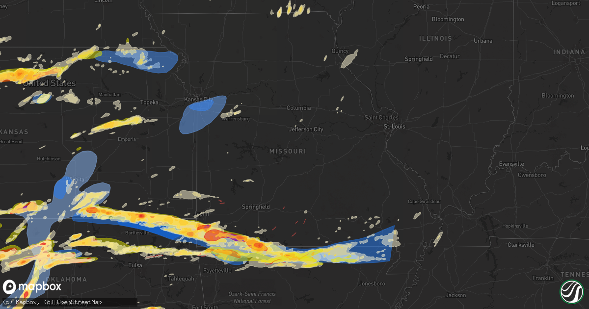
Hail Map in Missouri on May 25, 2024
Get this storm
May 25 map
$229
one time, instant access
Download today. No call, no setup
Keep the $229
Bought the map and want the full workflow? Apply the entire $229 to a subscription within 7 days. None of it is wasted.
Every map, not just this one
This buys you this map. Subscription and you get every map we run, in the markets you choose from a few cities to whole states to nationwide. Plus real-time alerts the moment a storm fires.
Contact data
Name, contact info, occupancy, even credit band for addresses in the footprint. You go from where it hit to who to call.
Become the source they trust
Unlimited branding weather history reports on demand. You already have the documented answer ready for the property owner, and you are the one who showed up with it.
Property data and RoofTrace estimates
Pull up any address you have got, its value and the exact code rules for that jurisdiction, straight from One Click Code. Then RoofTrace estimates the squares, pitch, and roof value, priced the way you price.
Storm reports in Missouri
Missouri
| Date | Description |
|---|---|
| 05/25/20246:50 AM CDT | A local report indicates 60 MPH wind near 1 S Poplar Bluff |
| 05/25/20246:47 AM CDT | Tree down on a house and a car. Cr 468 in poplar bluff. Many trees and lines down. |
| 05/25/20246:45 AM CDT | A local report indicates 60 MPH wind near 2 NNW Neelyville |
| 05/25/20246:44 AM CDT | Multiple trees and powerlines down. Several very large uprooted tress. Roof off a building. |
| 05/25/20246:42 AM CDT | Telephone poles snapped... Large limbs down... Structural damage to storage barns. |
| 05/25/20246:41 AM CDT | Home damage reported and multiple trees down in the fairdealing/harviell area. Possible tornado. |
| 05/25/20246:41 AM CDT | Home damage reported and multiple trees down in the fairdealing/harviell area. Possible tornado. |
| 05/25/20246:40 AM CDT | Reports of trees down south of doniphan and power lines down in portions of ripley county. |
| 05/25/20246:40 AM CDT | Corrects previous tstm wnd dmg report from 4 nw harviell. Shed destroyed. Possible tornado. Time was adjusted based on radar. |
| 05/25/20246:36 AM CDT | Report of roof blown off of home in naylor mo. |
| 05/25/20246:15 AM CDT | Corrects previous tornado report from 4 s gatewood. Ef-2 tornado... 115 mph. 38.6 mile track. |
| 05/25/20246:08 AM CDT | A local report indicates 1.00 inch wind near 1 ENE Thayer |
| 05/25/20246:07 AM CDT | Delayed report. Significant tree damage with several barns damaged near highway uu. Possible tornado. |
| 05/25/20246:06 AM CDT | Reports of trees down in southern iron co near reynolds co. Location and time approximate from radar. |
| 05/25/20246:05 AM CDT | Delayed report two large trees blown down on highway p west of alton. |
| 05/25/20246:04 AM CDT | Trees down over hwy 49 near black mo with report of car wreck due to downed tree. Time estimate from radar. |
| 05/25/20245:45 AM CDT | Multiple trees down across hwy 21. Location and time estimate from radar. |
| 05/25/20244:22 AM CDT | A local report indicates 2.75 inch wind near 1 N Lebanon |
| 05/25/20244:20 AM CDT | Numerous trees down with some twisted. Possibly associated with the 4 ene willhoit lsr tor. |
| 05/25/20244:20 AM CDT | Radar confirmed tds. |
| 05/25/20244:20 AM CDT | A local report indicates 1.00 inch wind near 3 N Ridgedale |
| 05/25/20244:19 AM CDT | Nws storm survey concluded an ef0 tornado with peak winds around 80 mph started over the caney mountain conservation area east of willhoit and travelled northeast for a |
| 05/25/20244:15 AM CDT | Report from mping... Quarter 1.00 in. |
| 05/25/20244:15 AM CDT | Report from mping... Golf ball 1.75 in. |
| 05/25/20244:15 AM CDT | Report from mping... Quarter 1.00 in. Time based on radar. |
| 05/25/20244:15 AM CDT | Report from mping... Hen egg+ 2.25 in. Time based on radar. |
| 05/25/20244:14 AM CDT | Report from mping... Quarter 1.00 in. |
| 05/25/20244:14 AM CDT | A local report indicates 1.75 inch wind near Blue Eye |
| 05/25/20244:12 AM CDT | 1/2 to 1 hail at my location... West side of branson. |
| 05/25/20244:12 AM CDT | Report from mping... Quarter 1.00 in. Time based on radar estimate. |
| 05/25/20244:12 AM CDT | Telephone poles and trees down... East side of ash grove. Time based on radar estimate. |
| 05/25/20244:12 AM CDT | Corrects previous tstm wnd dmg report from ash grove. Telephone poles and trees down... East side of ash grove. Time based on radar estimate. |
| 05/25/20244:11 AM CDT | A brief ef0 tornado touched down 5 miles southwest of buffalo. Maximum wind speeds of 65 mph with a width of 100 yards. Numerous large branches broken and a few trees s |
| 05/25/20244:06 AM CDT | Report of a tree across the road 95 just north of 14 eastern douglas county. Time based on radar estimate. |
| 05/25/20244:06 AM CDT | A local report indicates 1.00 inch wind near Kimberling City |
| 05/25/20244:05 AM CDT | Report from mping... Golf ball 1.75 in. |
| 05/25/20244:00 AM CDT | A local report indicates 1.50 inch wind near 1 NE Lampe |
| 05/25/20243:54 AM CDT | 2 rounds of hail at my home in shell knob on the barry/stone line. First was small... Most around pea to marble size... Second was much larger... Well over quarter size |
| 05/25/20243:54 AM CDT | Report from mping: golf ball |
| 05/25/20243:54 AM CDT | Report from mping... Quarter 1.00 in. Time based on radar. |
| 05/25/20243:54 AM CDT | Delayed report of two full size trees down at lake house near shell knob. |
| 05/25/20243:54 AM CDT | Vis social media. Time based on radar estimated. |
| 05/25/20243:48 AM CDT | Via social media. |
| 05/25/20243:48 AM CDT | Numerous trees down with some tops off of others. Power outage. |
| 05/25/20243:44 AM CDT | Radar confirmed tds. |
| 05/25/20243:42 AM CDT | Power-lines and trees down. Structures damaged. Possible tor. Time based on radar estimate. 2955 hwy f area. |
| 05/25/20243:39 AM CDT | Early sunday morning... An nws storm survey confirmed an ef 1 tornado touched down 6 miles northwest of mansfield in a hilly wooded area near highway f and quickly inte |
| 05/25/20243:38 AM CDT | Delayed report. Power poles and trees down west of cassville and butterfield in barry county. Time based on radar estimate. |
| 05/25/20243:38 AM CDT | Power poles and trees down west of cassville and butterfield in barry county. Time based on radar estimate. |
| 05/25/20243:38 AM CDT | Power poles and trees down in butterfield in barry county. Time based on radar estimate. |
| 05/25/20243:36 AM CDT | Via social media pictures of large trees down. Time based on radar estimate. |
| 05/25/20243:36 AM CDT | Corrects previous tstm wnd dmg report from 3 sse cassville to 5 wnw eagle rock. Via social media pictures of large trees down. Time based on radar estimate. |
| 05/25/20243:35 AM CDT | Report from mping... 3-inch tree limbs broken; power poles broken. Time based on radar estimate. |
| 05/25/20243:35 AM CDT | Report from mping... 3-inch tree limbs broken; power poles broken. Time based on radar. |
| 05/25/20243:33 AM CDT | Nws storm survey found an ef-0 tornado with maximum winds of 85mph in southwest dade county. Damage to trees and a barn occurred. An irrigation system was also flipped. |
| 05/25/20243:33 AM CDT | Radar confirmed tds just northeast of bradleyville. Continued northeast into douglas county. |
| 05/25/20243:32 AM CDT | Early sunday morning... An ef0 tornado crossed highway 125 1 mile north of bradleyville... Downing tree branches... Then uprooting trees east of the highway. Swirl mark |
| 05/25/20243:31 AM CDT | Powerlines down in wheaton. |
| 05/25/20243:30 AM CDT | Report from mping... 1-inch tree limbs broken; shingles blown off. Time based on radar. |
| 05/25/20243:30 AM CDT | Report from mping: quarter |
| 05/25/20243:30 AM CDT | Corrects previous hail report from 3 sse cassville to 5 wnw eagle rock. Via social media picture. Stated e70 mph winds. |
| 05/25/20243:30 AM CDT | Via social media picture. Stated e70 mph winds. |
| 05/25/20243:30 AM CDT | Several trees and limbs down in wheaton per le. Time based on radar. |
| 05/25/20243:27 AM CDT | Report from mping... Trees uprooted or snapped; roof blown off. Time based on radar. |
| 05/25/20243:25 AM CDT | Report from mping... 3-inch tree limbs broken; power poles broken. Time based on radar. |
| 05/25/20243:24 AM CDT | Just north of stella. |
| 05/25/20243:15 AM CDT | Report from mping: trees uprooted or snapped; roof blown off. Time based on radar. |
| 05/25/20243:10 AM CDT | Report from mping... Quarter 1.00 in. |
| 05/25/20243:03 AM CDT | Report from mping: quarter |
| 05/25/20243:00 AM CDT | Large tree took out several power lines in seneca mo off rhonda/grand ave. Time based on radar. |
| 05/25/20242:59 AM CDT | Golf ball hail 6 miles west of neosho. |
| 05/25/20242:58 AM CDT | Report from mping: quarter |
| 05/25/20242:58 AM CDT | Report from mping: hen egg |
| 05/25/20242:55 AM CDT | Roof blown off in seneca at highway 43. Time estimated radar. |
| 05/25/20242:53 AM CDT | Golf ball hail in neosho on highway 86. |
| 05/25/20241:32 AM CDT | Report of large tree over roadway along palis nichols drive near webster drive. Time estimated from radar. |
| 05/25/20241:28 AM CDT | Corrects previous tstm wnd dmg report from 2 wsw ashland. Report of large tree over roadway along palis nichols drive near webster drive. Time estimated from radar. |
| 05/25/202412:43 AM CDT | Large tree uprooted. Time estimated from radar. |
| 05/25/202412:25 AM CDT | Trees down... Including tree branch on a powerline. Time estimated by radar. |
| 05/25/202412:23 AM CDT | Tree limbs blown down. Time estimated from radar. |
| 05/25/202412:20 AM CDT | Law enforcement reports flying road signs. |
| 05/24/202411:48 PM CDT | Tree blown down. Time estimated from radar. |
| 05/24/202411:22 PM CDT | Mping report of 3 inch tree limbs broken; power poles broken in bates city. |
| 05/24/202411:20 PM CDT | Large tree snapped in half near ward and 65th. Time estimated from radar. |
| 05/24/202411:20 PM CDT | Several large tree branches down reported by the mayor. |
| 05/24/202411:18 PM CDT | Measured gust of 80 mph with large oak trees downed just southwest of downtown independence. |
| 05/24/202411:17 PM CDT | Large trees snapped on truman road north of grain valley. |
| 05/24/202411:15 PM CDT | Three large branches... At least 1 foot in diameter... Down near 97th and wornall. |
| 05/24/202411:15 PM CDT | Delayed mping report of trees snapped or uprooted in raytown. Time estimated from radar. |
| 05/24/202411:15 PM CDT | Peak gust of 81 mph measured from personal weather station just north of independence center. |
| 05/24/202411:11 PM CDT | Power lines downed in blue springs. Power is out. |
| 05/24/202411:10 PM CDT | Mping report of 3 inch tree limbs broken; power poles broken near the grandview triangle. |
| 05/24/202411:10 PM CDT | A local report indicates 74 MPH wind near 2 ENE Unity Village |
| 05/24/202411:09 PM CDT | Delayed report of large tree limbs... A large wooden utility pole... And power lines downed across missouri route 150 just west of the intersection with missouri route |
| 05/24/202411:07 PM CDT | Estimated 60 mph wind gusts at wfo pleasant hill. |
| 05/24/202411:07 PM CDT | Between visual estimation and measured gust from an automated weather station on site... Estimated 65 to 70 mph wind gusts at wfo pleasant hill. |
| 05/24/202411:05 PM CDT | Large tree branches down. |
| 05/24/202411:05 PM CDT | Large tree uprooted near douglas and elm. Another large tree blocking traffic at douglas and orchard. Time estimated from radar. |
| 05/24/202411:03 PM CDT | Large tree branches down. Time estimated via radar. |
| 05/24/202411:00 PM CDT | Large oak tree limb snapped on the west side of raintree lake. |
| 05/24/202410:53 PM CDT | Tree down at foxwood dr and park dr in raymore. |
| 05/24/202410:52 PM CDT | Tree down near lucy webb rd and silvertop ln in raymore. |
| 05/24/202410:49 PM CDT | Large tree over roadway at 203rd st and peculiar dr. |
All States Impacted by Hail Map on May 25, 2024
Cities Impacted by Hail Map on May 25, 2024
- Lebanon, TN
- Hartsville, TN
- Riddleton, TN
- Dixon Springs, TN
- Scotts Hill, TN
- Sardis, TN
- Reagan, TN
- Decaturville, TN
- Monticello, AR
- Crossville, AL
- Albertville, AL
- Springville, AL
- Ashville, AL
- Odenville, AL
- Grady, AR
- Dumas, AR
- Jasper, TN
- Tillar, AR
- Steele, AL
- Pell City, AL
- Talladega, AL
- Pickens, AR
- Winchester, AR
- Ragland, AL
- Lincoln, AL
- Riverside, AL
- Alpine, AL
- Goodwater, AL
- Clanton, AL
- Autaugaville, AL
- Billingsley, AL
- Rockford, AL
- Verbena, AL
- Prattville, AL
- Deatsville, AL
- Marbury, AL
- Jefferson, OH
- Pierpont, OH
- Dacula, GA
- Wetumpka, AL
- Equality, AL
- Montgomery, AL
- Conneautville, PA
- Titus, AL
- Transfer, PA
- Greenville, PA
- Cambridge Springs, PA
- Mercer, PA
- Fredonia, PA
- Macon, GA
- Ramer, AL
- Mathews, AL
- Grady, AL
- Goshen, AL
- Troy, AL
- Knox, PA
- Shippenville, PA
- Purlear, NC
- Cadwell, GA
- Marble, PA
- Butler, PA
- Rentz, GA
- Kellyton, AL
- Aliquippa, PA
- Monaca, PA
- Letohatchee, AL
- Soperton, GA
- Alamo, GA
- McRae Helena, GA
- Dublin, GA
- Brundidge, AL
- Ariton, AL
- Cordele, GA
- Delta, UT
- Blackwell, TX
- Enterprise, AL
- Ozark, AL
- Arabi, GA
- New Zion, SC
- Verona, PA
- Oakmont, PA
- Portal, GA
- Statesboro, GA
- Allison Park, PA
- Glenshaw, PA
- Greenville, AL
- Fort Deposit, AL
- Weinert, TX
- Fort Rucker, AL
- Marion, AL
- Marion Junction, AL
- Vero Beach, FL
- Maryneal, TX
- Selma, AL
- Pittsburgh, PA
- Cheswick, PA
- Pineview, GA
- Indianola, PA
- Tuscola, TX
- Wingate, TX
- Crowell, TX
- Seymour, TX
- Throckmorton, TX
- Haskell, TX
- Fort Pierce, FL
- Titusville, FL
- Munday, TX
- Goree, TX
- Georgetown, SC
- Salem, OH
- Columbiana, OH
- Leetonia, OH
- Millbrook, AL
- Gypsum, CO
- Eagle, CO
- Wolcott, CO
- Bond, CO
- Vail, CO
- Silverthorne, CO
- Avon, CO
- Edwards, CO
- Ovalo, TX
- Jones, AL
- Coosada, AL
- Prosperity, PA
- Washington, PA
- Pamplico, SC
- Noxapater, MS
- Chillicothe, TX
- Tyler, AL
- Lawn, TX
- Scooba, MS
- Emelle, AL
- Rutledge, AL
- Luverne, AL
- Cocoa, FL
- Eclectic, AL
- Amity, PA
- Acme, PA
- Mount Pleasant, PA
- Philadelphia, MS
- Odell, TX
- Vernon, TX
- Epes, AL
- Stamford, TX
- Hamlin, TX
- Newcastle, TX
- Louisville, MS
- Electra, TX
- Washingtonville, OH
- Merritt Island, FL
- Goldsboro, TX
- Clyde, TX
- Holliday, TX
- Olney, TX
- Hayneville, AL
- Davidson, OK
- Frederick, OK
- Dodson, MT
- Livingston, AL
- Shuqualak, MS
- Olustee, OK
- Elmer, OK
- Harrold, TX
- Oklaunion, TX
- Eldorado, OK
- Hay Springs, NE
- Headrick, OK
- Altus, OK
- Tipton, OK
- Malta, MT
- Macon, MS
- Aliceville, AL
- Hookstown, PA
- Baird, TX
- Cross Plains, TX
- Industry, PA
- Georgetown, PA
- Midland, PA
- Shippingport, PA
- Clinton, PA
- Snyder, OK
- Abilene, TX
- Chadron, NE
- Hoboken, GA
- Hollister, OK
- Imperial, PA
- Blair, OK
- Mountain Park, OK
- Bulger, PA
- McDonald, PA
- Coraopolis, PA
- Oakdale, PA
- Burgettstown, PA
- Roseboro, NC
- Brooksville, MS
- Avella, PA
- Roosevelt, OK
- Hobart, OK
- Mckeesport, PA
- North Versailles, PA
- McKees Rocks, PA
- Beaver, OK
- Laverne, OK
- Gate, OK
- Beaver, PA
- Windthorst, TX
- Andrews, SC
- Kingstree, SC
- Lone Wolf, OK
- Loveland, OK
- Burkett, TX
- Gotebo, OK
- Mountain View, OK
- Cordell, OK
- Carnegie, OK
- Carnegie, PA
- Presto, PA
- Morgan, PA
- Bridgeville, PA
- Altus Afb, OK
- Mangum, OK
- Dill City, OK
- Sentinel, OK
- Rocky, OK
- Indiahoma, OK
- Cache, OK
- Chattanooga, OK
- Lawton, OK
- Wexford, PA
- Valencia, PA
- Gibsonia, PA
- Randlett, OK
- Lowndesboro, AL
- Forgan, OK
- Sewickley, PA
- Burkburnett, TX
- Houston, PA
- Canonsburg, PA
- Strabane, PA
- Eighty Four, PA
- Cisco, TX
- Rising Star, TX
- Baden, PA
- Archer City, TX
- Crawford, MS
- Starkville, MS
- Conway, PA
- Ambridge, PA
- Freedom, PA
- De Kalb, MS
- Scotland, TX
- New Kensington, PA
- Carrollton, AL
- Eutaw, AL
- Devol, OK
- Canadian, TX
- Arnett, OK
- Homestead, PA
- Englewood, KS
- Rosston, OK
- Warrendale, PA
- Mars, PA
- Bradfordwoods, PA
- Meade, KS
- South Park, PA
- Bethel Park, PA
- Higgins, TX
- Grover, CO
- Ashland, KS
- Minneola, KS
- Bucklin, KS
- Ford, KS
- Colony, OK
- Corn, OK
- Hydro, OK
- Hinton, OK
- Apache, OK
- Ralph, AL
- Knoxville, AL
- Porterville, MS
- Bazine, KS
- Ness City, KS
- Shattuck, OK
- Henrietta, TX
- Iowa Park, TX
- Anadarko, OK
- Zebulon, NC
- Abbeville, GA
- Foss, OK
- Bessie, OK
- Clinton, OK
- Weatherford, OK
- North Lima, OH
- Fargo, OK
- Gage, OK
- Woodward, OK
- Sharon, OK
- Merriman, NE
- Comanche, OK
- Walters, OK
- Geary, OK
- Reform, AL
- Sycamore, PA
- Buhl, AL
- Protection, KS
- Wichita Falls, TX
- Coleman, TX
- Fayetteville, NC
- Fort Supply, OK
- Buffalo, OK
- Mooreland, OK
- Mullinville, KS
- Offerle, KS
- Spearville, KS
- Greensburg, KS
- Kinsley, KS
- Carbon, TX
- Watonga, OK
- Coldwater, KS
- Tuscaloosa, AL
- Fosters, AL
- Greenfield, OK
- Plainville, KS
- Ringgold, TX
- Nocona, TX
- Bellevue, TX
- Calumet, OK
- Waynesburg, PA
- Mount Morris, PA
- Morgantown, WV
- Pursglove, WV
- Maidsville, WV
- Mutual, OK
- Chester, OK
- De Leon, TX
- Gorman, TX
- Seiling, OK
- Taloga, OK
- Spraggs, PA
- Gainesville, AL
- Elrod, AL
- Gordo, AL
- Echola, AL
- Kingfisher, OK
- Northport, AL
- Omega, OK
- Comanche, TX
- Freedom, OK
- Alva, OK
- Thomas, OK
- Okarche, OK
- Hitchcock, OK
- Ames, OK
- Loyal, OK
- Okeene, OK
- Isabella, OK
- Dover, OK
- Hennessey, OK
- Waukomis, OK
- Drummond, OK
- Bison, OK
- Fairview, OK
- Wilmore, KS
- Lake City, KS
- Natoma, KS
- Ellis, KS
- Cottondale, AL
- Bogue, KS
- Otis, CO
- Hardtner, KS
- Hill City, KS
- Miami, FL
- Longdale, OK
- Ringwood, OK
- Meno, OK
- Ryan, OK
- Terral, OK
- Midway, PA
- Cedarbluff, MS
- Medicine Lodge, KS
- Fellsmere, FL
- Sumter, SC
- Brookwood, AL
- Kiowa, KS
- Sharon, KS
- Lahoma, OK
- Carrier, OK
- Enid, OK
- Hazelton, KS
- Kremlin, OK
- Nash, OK
- Stockton, KS
- Penokee, KS
- West Point, MS
- Cleo Springs, OK
- Dublin, TX
- Ringling, OK
- Pond Creek, OK
- Glade, KS
- Kirwin, KS
- Seven Springs, NC
- Mount Olive, NC
- Wilson, OK
- Preston, MS
- Summerton, SC
- Waynoka, OK
- Waldron, KS
- Attica, KS
- Anthony, KS
- Harper, KS
- Goltry, OK
- Helena, OK
- Jet, OK
- Cherokee, OK
- Carmen, OK
- Burlington, OK
- Amorita, OK
- Bluff City, KS
- Manchester, OK
- Wakita, OK
- Osborne, KS
- Bonneau, SC
- Carmichaels, PA
- Woodston, KS
- Downs, KS
- Medford, OK
- Caldwell, KS
- Aline, OK
- Burneyville, OK
- Leon, OK
- Dacoma, OK
- Kinston, NC
- New Smyrna Beach, FL
- Daytona Beach, FL
- La Grange, NC
- Deep Run, NC
- Stephenville, TX
- Gaylord, KS
- Alton, KS
- Glen Elder, KS
- Trenton, NE
- Tipton, KS
- Marietta, OK
- Overbrook, OK
- Douglas, OK
- Fairmont, OK
- Isabel, KS
- Ardmore, OK
- Cawker City, KS
- Mankato, KS
- Beloit, KS
- Garber, OK
- Covington, OK
- Perry, OK
- Lucien, OK
- Randall, KS
- Portis, KS
- Culbertson, NE
- Danville, KS
- Hunter, OK
- Ranger, TX
- Desdemona, TX
- Marshall, OK
- Madill, OK
- Orlando, OK
- Norway, KS
- McCook, NE
- Jewell, KS
- Cedar, KS
- Curtis, NE
- Chandlersville, OH
- Blue Rock, OH
- Bowie, TX
- Jamestown, KS
- Stillwater, OK
- Freeport, KS
- Argonia, KS
- Mayfield, KS
- Milan, KS
- South Haven, KS
- Wellington, KS
- Viola, KS
- Conway Springs, KS
- Clearwater, KS
- Goddard, KS
- Colwich, KS
- Wichita, KS
- Peck, KS
- Sedgwick, KS
- Bentley, KS
- Haysville, KS
- Belle Plaine, KS
- Valley Center, KS
- Maize, KS
- Mulvane, KS
- Newton, KS
- Derby, KS
- Geuda Springs, KS
- Oxford, KS
- Mcconnell Afb, KS
- Kechi, KS
- Rose Hill, KS
- Greenwich, KS
- Andover, KS
- Augusta, KS
- Benton, KS
- Billings, OK
- Red Rock, OK
- Winfield, KS
- Arkansas City, KS
- Andale, KS
- Garden Plain, KS
- Cheney, KS
- Milton, KS
- Norwich, KS
- Eustis, NE
- Concordia, KS
- Scandia, KS
- Belleville, KS
- Tonkawa, OK
- Mahaska, KS
- Jacksboro, TX
- Lamont, OK
- Blackwell, OK
- Ponca City, OK
- Morrison, OK
- Glencoe, OK
- Sunset, TX
- Forestburg, TX
- Montague, TX
- Bluff Dale, TX
- Udall, KS
- Maple City, KS
- Dexter, KS
- Haddam, KS
- Narka, KS
- Esbon, KS
- Agenda, KS
- Cuba, KS
- Morrowville, KS
- Washington, KS
- Saint Jo, TX
- Tolar, TX
- Columbus, MS
- Pawnee, OK
- Mannsville, OK
- Muenster, TX
- Rosston, TX
- Naponee, NE
- Bloomington, NE
- Rock, KS
- Atlanta, KS
- Ethelsville, AL
- Lewisville, OH
- Hollenberg, KS
- Hanover, KS
- Gainesville, TX
- Valley View, TX
- Marysville, KS
- Bremen, KS
- Odell, NE
- Sylvan Grove, KS
- Woodsfield, OH
- Marland, OK
- Lucas, KS
- Hunter, KS
- Burden, KS
- Diller, NE
- Clyde, KS
- Douglass, KS
- Latham, KS
- Leon, KS
- Cambridge, KS
- Lewis, KS
- Beatrice, NE
- De Witt, NE
- Pickrell, NE
- Alma, NE
- Sterling, KS
- Sardis, OH
- Halstead, KS
- North Newton, KS
- Whitewater, KS
- Walton, KS
- Peabody, KS
- Elbing, KS
- Florence, KS
- Burns, KS
- Towanda, KS
- El Dorado, KS
- Potwin, KS
- Oketo, KS
- Waterville, KS
- Home, KS
- Blue Rapids, KS
- Frankfort, KS
- Beattie, KS
- Fairfax, OK
- Ralston, OK
- Barnard, KS
- Era, TX
- Barnes, KS
- Greenleaf, KS
- Hesston, KS
- Lyons, KS
- Little River, KS
- Brookville, KS
- Salina, KS
- Tescott, KS
- Randolph, KS
- Bennington, KS
- Minneapolis, KS
- Clay Center, KS
- Ellsworth, KS
- Green, KS
- Kanopolis, KS
- Olsburg, KS
- Herington, KS
- Riley, KS
- Woodbine, KS
- Lost Springs, KS
- Fort Riley, KS
- Junction City, KS
- Marion, KS
- Manhattan, KS
- Lincolnville, KS
- Ramona, KS
- Waldo, KS
- Russell, KS
- Luray, KS
- Clifton, KS
- Palmer, KS
- Aurora, KS
- Victoria, KS
- Glasco, KS
- Hays, KS
- Burbank, OK
- Galva, KS
- Canton, KS
- Lincoln, KS
- Seneca, KS
- Summerfield, KS
- Axtell, KS
- Burchard, NE
- Wymore, NE
- Hominy, OK
- Beverly, KS
- Hillsboro, KS
- Pawnee City, NE
- Baileyville, KS
- Lehigh, KS
- Durham, KS
- Decatur, TX
- Wynona, OK
- Saint Paul, KS
- Cleveland, OK
- Sanger, TX
- Pawhuska, OK
- Barnsdall, OK
- Skiatook, OK
- Du Bois, NE
- Centralia, KS
- Westmoreland, KS
- Silver Creek, NE
- Schuyler, NE
- Osceola, NE
- Falls City, NE
- Onaga, KS
- Clarks, NE
- Venetia, PA
- Finleyville, PA
- McCune, KS
- Girard, KS
- Vermillion, KS
- Kennebec, SD
- Rogers, NE
- Delphos, KS
- Prue, OK
- Ramona, OK
- Paola, KS
- Osawatomie, KS
- Spring Hill, KS
- Bucyrus, KS
- Drexel, MO
- Louisburg, KS
- Stilwell, KS
- Cleveland, MO
- Raymore, MO
- Belton, MO
- Peculiar, MO
- Freeman, MO
- Harrisonville, MO
- Pleasant Hill, MO
- Bern, KS
- Sabetha, KS
- Oneida, KS
- Wetmore, KS
- Fairview, KS
- Netawaka, KS
- Goff, KS
- Corning, KS
- Tampa, KS
- Columbus, NE
- Bellwood, NE
- Franklin, NE
- Riverton, NE
- Craig, MO
- Collinsville, TX
- Weir, KS
- Pittsburg, KS
- Cherokee, KS
- Tioga, TX
- Burdick, KS
- Dodge, NE
- Orleans, NE
- Pilot Point, TX
- Lindsay, TX
- Humboldt, NE
- Table Rock, NE
- Fullerton, NE
- Hooper, NE
- Scribner, NE
- Phillipsburg, KS
- Wilsey, KS
- Morrill, KS
- Powhattan, KS
- Collinsville, OK
- Vera, OK
- Talala, OK
- Oologah, OK
- Gunter, TX
- North Bend, NE
- Fairfax, MO
- Agra, KS
- Kensington, KS
- Kansas City, MO
- Olathe, KS
- New Century, KS
- Gardner, KS
- Edgerton, KS
- Lenexa, KS
- Leawood, KS
- Overland Park, KS
- Grandview, MO
- Prairie Village, KS
- Blue Springs, MO
- Grain Valley, MO
- Sibley, MO
- Lees Summit, MO
- Oak Grove, MO
- Buckner, MO
- Independence, MO
- Greenwood, MO
- Odessa, MO
- Bates City, MO
- Holden, MO
- Lone Jack, MO
- Kingsville, MO
- Napoleon, MO
- Strasburg, MO
- Council Grove, KS
- Horton, KS
- Whiting, KS
- Claremore, OK
- Longford, KS
- Rock Port, MO
- Celina, TX
- Howe, TX
- Van Alstyne, TX
- Anna, TX
- Owasso, OK
- Chelsea, OK
- Adair, OK
- Pryor, OK
- Alma, KS
- Alta Vista, KS
- Allen, KS
- Herman, NE
- Craig, NE
- Hiawatha, KS
- Mondamin, IA
- Genoa, NE
- Monroe, NE
- Everest, KS
- Whitewright, TX
- Blue Ridge, TX
- Honey Creek, IA
- McClelland, IA
- Council Bluffs, IA
- Carter Lake, IA
- Crescent, IA
- Omaha, NE
- Underwood, IA
- Highland, KS
- White Cloud, KS
- Robinson, KS
- Troy, KS
- Oregon, MO
- Denton, KS
- Bendena, KS
- Wathena, KS
- Lancaster, KS
- Atchison, KS
- Muscotah, KS
- Effingham, KS
- Tekamah, NE
- Norton, KS
- Cuddy, PA
- Sturgeon, PA
- Big Cabin, OK
- Strang, OK
- Emlenton, PA
- Kennerdell, PA
- Hadley, PA
- West Mifflin, PA
- Hickory, PA
- Chapman, KS
- Leonard, TX
- Trenton, TX
- Chester, WV
- Pisgah, IA
- Milford, KS
- Harrisonville, PA
- Mission, KS
- Levasy, MO
- Shawnee, KS
- Kansas City, KS
- Lebanon, KS
- Fair Play, MO
- Celeste, TX
- Cedar Vale, KS
- Eskridge, KS
- Harveyville, KS
- Reading, KS
- Vinita, OK
- Salina, OK
- Spavinaw, OK
- Farmersville, TX
- Republican City, NE
- Dunnegan, MO
- Lexington, MO
- Orrick, MO
- Wellington, MO
- Braman, OK
- Newkirk, OK
- Shidler, OK
- Burlingame, KS
- Osage City, KS
- Jay, OK
- Eucha, OK
- Colcord, OK
- Burr Oak, KS
- Wolfe City, TX
- Bolivar, MO
- Appleton City, MO
- Greenville, TX
- La Vista, NE
- Bellevue, NE
- Papillion, NE
- Gretna, NE
- Boys Town, NE
- Springfield, NE
- Eufaula, OK
- Garden City, TX
- Scranton, KS
- Sedan, KS
- Antlers, OK
- Checotah, OK
- Peru, KS
- Chautauqua, KS
- Cambridge, IA
- Nevada, IA
- Ames, IA
- Moyers, OK
- Diagonal, IA
- Courtland, KS
- Quenemo, KS
- Overbrook, KS
- Sterling City, TX
- Maysville, AR
- Gravette, AR
- Decatur, AR
- Commerce, TX
- Gentry, AR
- Formoso, KS
- Maple Hill, KS
- Story City, IA
- Niotaze, KS
- Caney, KS
- Roland, IA
- Havana, KS
- Topeka, KS
- Sherman, TX
- Porum, OK
- Carlsbad, TX
- Unionville, MO
- Murray, IA
- Mertzon, TX
- Robert Lee, TX
- Independence, KS
- Big Lake, TX
- Elk City, KS
- Iowa Falls, IA
- Eldora, IA
- Tyro, KS
- Coffeyville, KS
- Copan, OK
- Hiwasse, AR
- Bentonville, AR
- Wann, OK
- Centerton, AR
- Bella Vista, AR
- Livonia, MO
- Wellsburg, IA
- Dearing, KS
- Liberty, KS
- S Coffeyville, OK
- Bartlesville, OK
- Dewey, OK
- Lytton, IA
- Sac City, IA
- San Angelo, TX
- Steamboat Rock, IA
- Ackley, IA
- Bronte, TX
- Aplington, IA
- Moulton, IA
- Exline, IA
- Glenwood, MO
- Lancaster, MO
- Wagoner, OK
- Hulbert, OK
- Rogers, AR
- Fort Gibson, OK
- Lenapah, OK
- Downing, MO
- Cincinnati, IA
- Pea Ridge, AR
- Garfield, AR
- Bloomfield, IA
- Cherryvale, KS
- Winters, TX
- Coatsville, MO
- Memphis, MO
- Pulaski, IA
- Welch, OK
- Edna, KS
- Delaware, OK
- Henryetta, OK
- Austinville, IA
- Bluejacket, OK
- Mound Valley, KS
- Bartlett, KS
- Chetopa, KS
- Goodfellow Afb, TX
- High Hill, MO
- Cantril, IA
- Afton, OK
- Drakesville, IA
- Albia, IA
- Milton, IA
- Belle Plaine, IA
- Marengo, IA
- New Florence, MO
- Mount Pleasant, IA
- White City, KS
- Dwight, KS
- Philadelphia, MO
- Monroe City, MO
- Eureka Springs, AR
- Lowell, AR
- Cave Springs, AR
- Hindsville, AR
- Picher, OK
- Miami, OK
- Mitchellville, IA
- Montgomery City, MO
- Ballinger, TX
- Blairstown, IA
- Van Horne, IA
- Norton, TX
- Miles, TX
- Grove, OK
- Wyandotte, OK
- Anderson, MO
- Tiff City, MO
- Mount Union, IA
- State Center, IA
- Rhodes, IA
- Miltonvale, KS
- Abilene, KS
- Solomon, KS
- Luzerne, IA
- New London, IA
- Winfield, IA
- Palmyra, MO
- Fairland, OK
- Colfax, IA
- Springdale, AR
- Huntsville, AR
- Middletown, MO
- Bellflower, MO
- New London, MO
- Strong City, KS
- Emporia, KS
- Neosho, MO
- Seneca, MO
- Nowata, OK
- Commerce, OK
- Quapaw, OK
- North Miami, OK
- Stockton, MO
- Grinnell, IA
- Keystone, IA
- Mingo, IA
- Novice, TX
- Barnhart, TX
- Berryville, AR
- Morning Sun, IA
- Yarmouth, IA
- Malcom, IA
- Goodman, MO
- Hull, IL
- Hannibal, MO
- Sully, IA
- Lynnville, IA
- Newton, IA
- Talpa, TX
- Rowena, TX
- Joplin, MO
- Victor, IA
- Montezuma, IA
- Brooklyn, IA
- Hartwick, IA
- Marshalltown, IA
- Ladora, IA
- Talmage, KS
- Liberty, IL
- Kinderhook, IL
- Plainville, IL
- Barry, IL
- Payson, IL
- Green Forest, AR
- Valera, TX
- Alpena, AR
- Harrison, AR
- Omaha, AR
- Granby, MO
- North Liberty, IA
- Solon, IA
- Powell, MO
- Pineville, MO
- Garwin, IA
- Traer, IA
- Gladbrook, IA
- Toledo, IA
- Chelsea, IA
- South West City, MO
- Stella, MO
- Stark City, MO
- Camp Point, IL
- Clayton, IL
- Walnut Shade, MO
- Forsyth, MO
- Clutier, IA
- Elberon, IA
- Parsons, KS
- Rocky Comfort, MO
- Norway, IA
- Galena, KS
- Fairview, MO
- Purdy, MO
- Exeter, MO
- Cassville, MO
- Butterfield, MO
- Wheaton, MO
- Washburn, MO
- Buckingham, IA
- Basco, IL
- Carthage, IL
- Watkins, IA
- Amana, IA
- La Porte City, IA
- May, TX
- Brownwood, TX
- Dysart, IA
- Ely, IA
- Warrensburg, MO
- Higginsville, MO
- Centerview, MO
- Hudson, IA
- Taneyville, MO
- Lanagan, MO
- Noel, MO
- Pierce City, MO
- Santa Anna, TX
- Columbus Junction, IA
- Centertown, MO
- Marble Falls, AR
- Compton, AR
- Seligman, MO
- Sulphur Springs, AR
- Everton, AR
- Bradleyville, MO
- Ava, MO
- Seymour, MO
- Sarcoxie, MO
- Golden City, MO
- Lockwood, MO
- Iowa City, IA
- Cedar Rapids, IA
- Mount Vernon, IA
- Monett, MO
- Dallas City, IL
- Aurora, MO
- Shell Knob, MO
- Bangs, TX
- Keithsburg, IL
- Muscatine, IA
- Letts, IA
- Mount Sterling, IL
- Yellville, AR
- Yates Center, KS
- Jesup, IA
- Eagle Rock, MO
- Christoval, TX
- Seaton, IL
- Concordia, MO
- Pyatt, AR
- Rushville, IL
- Vinton, IA
- Kimberling City, MO
- Lampe, MO
- Golden, MO
- Galena, MO
- Reeds Spring, MO
- Cape Fair, MO
- Blue Eye, MO
- Waterloo, IA
- Springville, IA
- Mechanicsville, IA
- Martelle, IA
- Lisbon, IA
- Frederick, IL
- Browning, IL
- Wall, TX
- Eola, TX
- Murrayville, IL
- Winchester, IL
- Hartsburg, MO
- Ashland, MO
- Baxter Springs, KS
- Summit, AR
- Columbus, KS
- Riverton, KS
- Moran, KS
- Flippin, AR
- Bull Shoals, AR
- Lakeview, AR
- Cotter, AR
- Gassville, AR
- Vancourt, TX
- Mansfield, MO
- Astoria, IL
- Chandlerville, IL
- Bath, IL
- Jacksonville, IL
- Oak Grove, AR
- Ridgedale, MO
- Carthage, MO
- Mountain Home, AR
- Webb City, MO
- Paint Rock, TX
- Anamosa, IA
- Millington, TN
- Bronson, KS
- Branson, MO
- Hollister, MO
- Midway, AR
- Henderson, AR
- Elizabeth, AR
- Aledo, IL
- Chanute, KS
- Benedict, KS
- Eden, TX
- Kirbyville, MO
- Drummonds, TN
- Munford, TN
- Cedarcreek, MO
- Lead Hill, AR
- Chestnutridge, MO
- Spokane, MO
- Reeds, MO
- Norfork, AR
- Protem, MO
- Peel, AR
- Drury, MO
- Brixey, MO
- Vanzant, MO
- Melvin, TX
- Lohn, TX
- Brady, TX
- Arlington, TX
- Early, TX
- Humboldt, KS
- Millersview, TX
- Alexis, IL
- Rockaway Beach, MO
- Calico Rock, AR
- Isabella, MO
- Theodosia, MO
- Gainesville, MO
- Pontiac, MO
- Rueter, MO
- Oakland, AR
- Puxico, MO
- Mountain Grove, MO
- Viola, AR
- Salem, AR
- Grand Prairie, TX
- Rio, IL
- Oneida, IL
- Woodhull, IL
- Alpha, IL
- Zephyr, TX
- Mullin, TX
- Irving, TX
- Verona, MO
- Gustine, TX
- Priddy, TX
- Gepp, AR
- Petersburg, IL
- Bexar, AR
- Dolph, AR
- Topeka, IL
- Manito, IL
- Rochelle, TX
- Richland Springs, TX
- Sturkie, AR
- Western Grove, AR
- Cabool, MO
- Hamilton, TX
- Camp, AR
- Gamaliel, AR
- Clarkridge, AR
- Pineville, AR
- Valley Springs, AR
- Mammoth Spring, AR
- Royse City, TX
- Birch Tree, MO
- Winona, MO
- Wideman, AR
- Oxford, AR
- Glencoe, AR
- Wiseman, AR
- Violet Hill, AR
- Horseshoe Bend, AR
- Ash Flat, AR
- Goldthwaite, TX
- Fremont, MO
- Terrell, TX
- Thayer, MO
- Zalma, MO
- Caddo Mills, TX
- Couch, MO
- Hardy, AR
- Ravenden, AR
- San Saba, TX
- Lone Oak, TX
- Alton, MO
- West Plains, MO
- Cherokee Village, AR
- Koshkonong, MO
- Pocahontas, AR
- Myrtle, MO
- Quinlan, TX
- Van Buren, MO
- Frontenac, KS
- Brockwell, AR
- Ravenden Springs, AR
- Franklin, AR
- Ellsinore, MO
- Williford, AR
- Union City, TN
- Hickman, KY
- Mindenmines, MO
- Asbury, MO
- Doniphan, MO
- Bell City, MO
- Imboden, AR
- Warm Springs, AR
- Gatewood, MO
- Jonesboro, TX
- Grandin, MO
- Black Rock, AR
- Maynard, AR
- Mill Spring, MO
- East Prairie, MO
- Lamar, MO
- Jasper, MO
- Liberal, MO
- Oronogo, MO
- Poplar Bluff, MO
- Oran, MO
- Peach Orchard, AR
- Corning, AR
- Biggers, AR
- Delaplaine, AR
- Paragould, AR
- Rector, AR
- Knobel, AR
- Datto, AR
- Lafe, AR
- Clinton, IL
- Maroa, IL
- Williamsville, MO
- Star, TX
- Evant, TX
- Fairdealing, MO
- Harviell, MO
- Neelyville, MO
- Clinton, KY
- Naylor, MO
- Success, AR
- Benton, MO
- Oxly, MO
- Pollard, AR
- Qulin, MO
- Piggott, AR
- Marmaduke, AR
- Greenway, AR
- Campbell, MO
- Broseley, MO
- Fisk, MO
- Dudley, MO
- Lometa, TX
- Kell, IL
- Bernie, MO
- Malden, MO
- Downs, IL
- Wapella, IL
- Logan, KS
- Mckinney, TX


