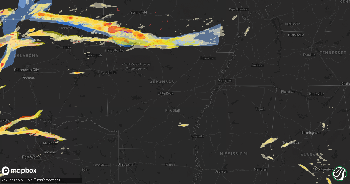
Hail Map in Arkansas on May 25, 2024
Get this storm
May 25 map
$229
one time, instant access
Download today. No call, no setup
Keep the $229
Bought the map and want the full workflow? Apply the entire $229 to a subscription within 7 days. None of it is wasted.
Every map, not just this one
This buys you this map. Subscription and you get every map we run, in the markets you choose from a few cities to whole states to nationwide. Plus real-time alerts the moment a storm fires.
Contact data
Name, contact info, occupancy, even credit band for addresses in the footprint. You go from where it hit to who to call.
Become the source they trust
Unlimited branding weather history reports on demand. You already have the documented answer ready for the property owner, and you are the one who showed up with it.
Property data and RoofTrace estimates
Pull up any address you have got, its value and the exact code rules for that jurisdiction, straight from One Click Code. Then RoofTrace estimates the squares, pitch, and roof value, priced the way you price.
Storm reports in Arkansas
Arkansas
| Date | Description |
|---|---|
| 05/25/20246:36 AM CDT | Large tree down in corning... Blocking a road. Time is radar estimated. |
| 05/25/20246:30 AM CDT | Trees down. |
| 05/25/20246:28 AM CDT | Nws damage survey team has found damage associated with a short track ef-1 tornado that occurred early sunday morning in randolph county. Significant roof loss and othe |
| 05/25/20246:21 AM CDT | Report of multiple roads blocked due to downed trees and power lines. |
| 05/25/20246:20 AM CDT | Nws damage survey team has found damage associated with another ef-1 tornado that occurred early sunday morning in randolph county... South and east of attica. Numerous |
| 05/25/20246:00 AM CDT | Nws damage survey team has found damage associated with an short lived ef-1 tornado that occurred early sunday morning in sharp county... Just north of williford. A num |
| 05/25/20246:00 AM CDT | **this is a delayed report** mesonet station fw0859 ash flat. |
| 05/25/20245:53 AM CDT | Measured at sharp county regional airport. |
| 05/25/20245:08 AM CDT | Nws damage survey has found damage associated with a short track ef-1 tornado that occurred early sunday morning in fulton county. Numerous trees were downed along the |
| 05/25/20244:48 AM CDT | House reported to be damaged on starkey road. This was a radar confirmed tornado at time of report. |
| 05/25/20244:31 AM CDT | Multiple roads in county blocked due to downed trees and power lines. Time estimated by radar observations. |
| 05/25/20244:26 AM CDT | Trees reported down and roof damage reported to homes. Report related by ky3. |
| 05/25/20244:25 AM CDT | Nws damage survey team has preliminarily found low-end ef-3 damage associated with a tornado that occurred early sunday morning in baxter county. Since the team is stil |
| 05/25/20244:19 AM CDT | A local report indicates 2.50 inch wind near Omaha |
| 05/25/20244:07 AM CDT | Trees damaged by thunderstorm wind gust. |
| 05/25/20243:47 AM CDT | Multiple trees and power lines downed. This was a radar confirmed tornado at time of report. |
| 05/25/20243:33 AM CDT | Corrects previous tornado report from 1 ssw olvey. House reported to be damaged on starkey road. This was a radar confirmed tornado at time of report. |
| 05/25/20243:33 AM CDT | *** 1 fatal *** updated and corrected previously issued tornado report from 1 ssw olvey. House reported to be damaged on starkey road. This was a radar confirmed tornad |
| 05/25/20243:33 AM CDT | Corrects previous tornado report from 1 sw olvey. Nws damage survey crew has preliminarily found low-end ef-3 damage associated with a tornado that occurred early this |
| 05/25/20242:53 AM CDT | Report from mping: quarter |
| 05/25/20242:31 AM CDT | A local report indicates 1.00 inch wind near 4 SW Grandview |
| 05/25/20241:52 AM CDT | Reports of damage in rogers...possible tornado. |
| 05/25/20241:52 AM CDT | A local report indicates 62 MPH wind near 3 NNE Rogers |
| 05/25/20241:47 AM CDT | Report from mping: quarter as closed from 2nd street to lost lane in gypsum due to a fallen tree. The road was closed for 40 minutes. |
| 05/25/20241:47 AM CDT | Extensive tree damage. Multiple trees down. Large tree limb penetrated home. Near intersection of ridgefield and robson way. |
| 05/25/20241:47 AM CDT | Report from mping: quarter |
| 05/25/20241:47 AM CDT | Large trees down. |
| 05/25/20241:41 AM CDT | A local report indicates 1.00 inch wind near 2 N Bella Vista |
| 05/25/20241:36 AM CDT | Report from mping: quarter |
| 05/25/20241:15 AM CDT | Anticyclonic tornado with tds on radar. |
| 05/25/20241:10 AM CDT | Tds on radar. |
All States Impacted by Hail Map on May 25, 2024
Cities Impacted by Hail Map on May 25, 2024
- Lebanon, TN
- Hartsville, TN
- Riddleton, TN
- Dixon Springs, TN
- Scotts Hill, TN
- Sardis, TN
- Reagan, TN
- Decaturville, TN
- Monticello, AR
- Crossville, AL
- Albertville, AL
- Springville, AL
- Ashville, AL
- Odenville, AL
- Grady, AR
- Dumas, AR
- Jasper, TN
- Tillar, AR
- Steele, AL
- Pell City, AL
- Talladega, AL
- Pickens, AR
- Winchester, AR
- Ragland, AL
- Lincoln, AL
- Riverside, AL
- Alpine, AL
- Goodwater, AL
- Clanton, AL
- Autaugaville, AL
- Billingsley, AL
- Rockford, AL
- Verbena, AL
- Prattville, AL
- Deatsville, AL
- Marbury, AL
- Jefferson, OH
- Pierpont, OH
- Dacula, GA
- Wetumpka, AL
- Equality, AL
- Montgomery, AL
- Conneautville, PA
- Titus, AL
- Transfer, PA
- Greenville, PA
- Cambridge Springs, PA
- Mercer, PA
- Fredonia, PA
- Macon, GA
- Ramer, AL
- Mathews, AL
- Grady, AL
- Goshen, AL
- Troy, AL
- Knox, PA
- Shippenville, PA
- Purlear, NC
- Cadwell, GA
- Marble, PA
- Butler, PA
- Rentz, GA
- Kellyton, AL
- Aliquippa, PA
- Monaca, PA
- Letohatchee, AL
- Soperton, GA
- Alamo, GA
- McRae Helena, GA
- Dublin, GA
- Brundidge, AL
- Ariton, AL
- Cordele, GA
- Delta, UT
- Blackwell, TX
- Enterprise, AL
- Ozark, AL
- Arabi, GA
- New Zion, SC
- Verona, PA
- Oakmont, PA
- Portal, GA
- Statesboro, GA
- Allison Park, PA
- Glenshaw, PA
- Greenville, AL
- Fort Deposit, AL
- Weinert, TX
- Fort Rucker, AL
- Marion, AL
- Marion Junction, AL
- Vero Beach, FL
- Maryneal, TX
- Selma, AL
- Pittsburgh, PA
- Cheswick, PA
- Pineview, GA
- Indianola, PA
- Tuscola, TX
- Wingate, TX
- Crowell, TX
- Seymour, TX
- Throckmorton, TX
- Haskell, TX
- Fort Pierce, FL
- Titusville, FL
- Munday, TX
- Goree, TX
- Georgetown, SC
- Salem, OH
- Columbiana, OH
- Leetonia, OH
- Millbrook, AL
- Gypsum, CO
- Eagle, CO
- Wolcott, CO
- Bond, CO
- Vail, CO
- Silverthorne, CO
- Avon, CO
- Edwards, CO
- Ovalo, TX
- Jones, AL
- Coosada, AL
- Prosperity, PA
- Washington, PA
- Pamplico, SC
- Noxapater, MS
- Chillicothe, TX
- Tyler, AL
- Lawn, TX
- Scooba, MS
- Emelle, AL
- Rutledge, AL
- Luverne, AL
- Cocoa, FL
- Eclectic, AL
- Amity, PA
- Acme, PA
- Mount Pleasant, PA
- Philadelphia, MS
- Odell, TX
- Vernon, TX
- Epes, AL
- Stamford, TX
- Hamlin, TX
- Newcastle, TX
- Louisville, MS
- Electra, TX
- Washingtonville, OH
- Merritt Island, FL
- Goldsboro, TX
- Clyde, TX
- Holliday, TX
- Olney, TX
- Hayneville, AL
- Davidson, OK
- Frederick, OK
- Dodson, MT
- Livingston, AL
- Shuqualak, MS
- Olustee, OK
- Elmer, OK
- Harrold, TX
- Oklaunion, TX
- Eldorado, OK
- Hay Springs, NE
- Headrick, OK
- Altus, OK
- Tipton, OK
- Malta, MT
- Macon, MS
- Aliceville, AL
- Hookstown, PA
- Baird, TX
- Cross Plains, TX
- Industry, PA
- Georgetown, PA
- Midland, PA
- Shippingport, PA
- Clinton, PA
- Snyder, OK
- Abilene, TX
- Chadron, NE
- Hoboken, GA
- Hollister, OK
- Imperial, PA
- Blair, OK
- Mountain Park, OK
- Bulger, PA
- McDonald, PA
- Coraopolis, PA
- Oakdale, PA
- Burgettstown, PA
- Roseboro, NC
- Brooksville, MS
- Avella, PA
- Roosevelt, OK
- Hobart, OK
- Mckeesport, PA
- North Versailles, PA
- McKees Rocks, PA
- Beaver, OK
- Laverne, OK
- Gate, OK
- Beaver, PA
- Windthorst, TX
- Andrews, SC
- Kingstree, SC
- Lone Wolf, OK
- Loveland, OK
- Burkett, TX
- Gotebo, OK
- Mountain View, OK
- Cordell, OK
- Carnegie, OK
- Carnegie, PA
- Presto, PA
- Morgan, PA
- Bridgeville, PA
- Altus Afb, OK
- Mangum, OK
- Dill City, OK
- Sentinel, OK
- Rocky, OK
- Indiahoma, OK
- Cache, OK
- Chattanooga, OK
- Lawton, OK
- Wexford, PA
- Valencia, PA
- Gibsonia, PA
- Randlett, OK
- Lowndesboro, AL
- Forgan, OK
- Sewickley, PA
- Burkburnett, TX
- Houston, PA
- Canonsburg, PA
- Strabane, PA
- Eighty Four, PA
- Cisco, TX
- Rising Star, TX
- Baden, PA
- Archer City, TX
- Crawford, MS
- Starkville, MS
- Conway, PA
- Ambridge, PA
- Freedom, PA
- De Kalb, MS
- Scotland, TX
- New Kensington, PA
- Carrollton, AL
- Eutaw, AL
- Devol, OK
- Canadian, TX
- Arnett, OK
- Homestead, PA
- Englewood, KS
- Rosston, OK
- Warrendale, PA
- Mars, PA
- Bradfordwoods, PA
- Meade, KS
- South Park, PA
- Bethel Park, PA
- Higgins, TX
- Grover, CO
- Ashland, KS
- Minneola, KS
- Bucklin, KS
- Ford, KS
- Colony, OK
- Corn, OK
- Hydro, OK
- Hinton, OK
- Apache, OK
- Ralph, AL
- Knoxville, AL
- Porterville, MS
- Bazine, KS
- Ness City, KS
- Shattuck, OK
- Henrietta, TX
- Iowa Park, TX
- Anadarko, OK
- Zebulon, NC
- Abbeville, GA
- Foss, OK
- Bessie, OK
- Clinton, OK
- Weatherford, OK
- North Lima, OH
- Fargo, OK
- Gage, OK
- Woodward, OK
- Sharon, OK
- Merriman, NE
- Comanche, OK
- Walters, OK
- Geary, OK
- Reform, AL
- Sycamore, PA
- Buhl, AL
- Protection, KS
- Wichita Falls, TX
- Coleman, TX
- Fayetteville, NC
- Fort Supply, OK
- Buffalo, OK
- Mooreland, OK
- Mullinville, KS
- Offerle, KS
- Spearville, KS
- Greensburg, KS
- Kinsley, KS
- Carbon, TX
- Watonga, OK
- Coldwater, KS
- Tuscaloosa, AL
- Fosters, AL
- Greenfield, OK
- Plainville, KS
- Ringgold, TX
- Nocona, TX
- Bellevue, TX
- Calumet, OK
- Waynesburg, PA
- Mount Morris, PA
- Morgantown, WV
- Pursglove, WV
- Maidsville, WV
- Mutual, OK
- Chester, OK
- De Leon, TX
- Gorman, TX
- Seiling, OK
- Taloga, OK
- Spraggs, PA
- Gainesville, AL
- Elrod, AL
- Gordo, AL
- Echola, AL
- Kingfisher, OK
- Northport, AL
- Omega, OK
- Comanche, TX
- Freedom, OK
- Alva, OK
- Thomas, OK
- Okarche, OK
- Hitchcock, OK
- Ames, OK
- Loyal, OK
- Okeene, OK
- Isabella, OK
- Dover, OK
- Hennessey, OK
- Waukomis, OK
- Drummond, OK
- Bison, OK
- Fairview, OK
- Wilmore, KS
- Lake City, KS
- Natoma, KS
- Ellis, KS
- Cottondale, AL
- Bogue, KS
- Otis, CO
- Hardtner, KS
- Hill City, KS
- Miami, FL
- Longdale, OK
- Ringwood, OK
- Meno, OK
- Ryan, OK
- Terral, OK
- Midway, PA
- Cedarbluff, MS
- Medicine Lodge, KS
- Fellsmere, FL
- Sumter, SC
- Brookwood, AL
- Kiowa, KS
- Sharon, KS
- Lahoma, OK
- Carrier, OK
- Enid, OK
- Hazelton, KS
- Kremlin, OK
- Nash, OK
- Stockton, KS
- Penokee, KS
- West Point, MS
- Cleo Springs, OK
- Dublin, TX
- Ringling, OK
- Pond Creek, OK
- Glade, KS
- Kirwin, KS
- Seven Springs, NC
- Mount Olive, NC
- Wilson, OK
- Preston, MS
- Summerton, SC
- Waynoka, OK
- Waldron, KS
- Attica, KS
- Anthony, KS
- Harper, KS
- Goltry, OK
- Helena, OK
- Jet, OK
- Cherokee, OK
- Carmen, OK
- Burlington, OK
- Amorita, OK
- Bluff City, KS
- Manchester, OK
- Wakita, OK
- Osborne, KS
- Bonneau, SC
- Carmichaels, PA
- Woodston, KS
- Downs, KS
- Medford, OK
- Caldwell, KS
- Aline, OK
- Burneyville, OK
- Leon, OK
- Dacoma, OK
- Kinston, NC
- New Smyrna Beach, FL
- Daytona Beach, FL
- La Grange, NC
- Deep Run, NC
- Stephenville, TX
- Gaylord, KS
- Alton, KS
- Glen Elder, KS
- Trenton, NE
- Tipton, KS
- Marietta, OK
- Overbrook, OK
- Douglas, OK
- Fairmont, OK
- Isabel, KS
- Ardmore, OK
- Cawker City, KS
- Mankato, KS
- Beloit, KS
- Garber, OK
- Covington, OK
- Perry, OK
- Lucien, OK
- Randall, KS
- Portis, KS
- Culbertson, NE
- Danville, KS
- Hunter, OK
- Ranger, TX
- Desdemona, TX
- Marshall, OK
- Madill, OK
- Orlando, OK
- Norway, KS
- McCook, NE
- Jewell, KS
- Cedar, KS
- Curtis, NE
- Chandlersville, OH
- Blue Rock, OH
- Bowie, TX
- Jamestown, KS
- Stillwater, OK
- Freeport, KS
- Argonia, KS
- Mayfield, KS
- Milan, KS
- South Haven, KS
- Wellington, KS
- Viola, KS
- Conway Springs, KS
- Clearwater, KS
- Goddard, KS
- Colwich, KS
- Wichita, KS
- Peck, KS
- Sedgwick, KS
- Bentley, KS
- Haysville, KS
- Belle Plaine, KS
- Valley Center, KS
- Maize, KS
- Mulvane, KS
- Newton, KS
- Derby, KS
- Geuda Springs, KS
- Oxford, KS
- Mcconnell Afb, KS
- Kechi, KS
- Rose Hill, KS
- Greenwich, KS
- Andover, KS
- Augusta, KS
- Benton, KS
- Billings, OK
- Red Rock, OK
- Winfield, KS
- Arkansas City, KS
- Andale, KS
- Garden Plain, KS
- Cheney, KS
- Milton, KS
- Norwich, KS
- Eustis, NE
- Concordia, KS
- Scandia, KS
- Belleville, KS
- Tonkawa, OK
- Mahaska, KS
- Jacksboro, TX
- Lamont, OK
- Blackwell, OK
- Ponca City, OK
- Morrison, OK
- Glencoe, OK
- Sunset, TX
- Forestburg, TX
- Montague, TX
- Bluff Dale, TX
- Udall, KS
- Maple City, KS
- Dexter, KS
- Haddam, KS
- Narka, KS
- Esbon, KS
- Agenda, KS
- Cuba, KS
- Morrowville, KS
- Washington, KS
- Saint Jo, TX
- Tolar, TX
- Columbus, MS
- Pawnee, OK
- Mannsville, OK
- Muenster, TX
- Rosston, TX
- Naponee, NE
- Bloomington, NE
- Rock, KS
- Atlanta, KS
- Ethelsville, AL
- Lewisville, OH
- Hollenberg, KS
- Hanover, KS
- Gainesville, TX
- Valley View, TX
- Marysville, KS
- Bremen, KS
- Odell, NE
- Sylvan Grove, KS
- Woodsfield, OH
- Marland, OK
- Lucas, KS
- Hunter, KS
- Burden, KS
- Diller, NE
- Clyde, KS
- Douglass, KS
- Latham, KS
- Leon, KS
- Cambridge, KS
- Lewis, KS
- Beatrice, NE
- De Witt, NE
- Pickrell, NE
- Alma, NE
- Sterling, KS
- Sardis, OH
- Halstead, KS
- North Newton, KS
- Whitewater, KS
- Walton, KS
- Peabody, KS
- Elbing, KS
- Florence, KS
- Burns, KS
- Towanda, KS
- El Dorado, KS
- Potwin, KS
- Oketo, KS
- Waterville, KS
- Home, KS
- Blue Rapids, KS
- Frankfort, KS
- Beattie, KS
- Fairfax, OK
- Ralston, OK
- Barnard, KS
- Era, TX
- Barnes, KS
- Greenleaf, KS
- Hesston, KS
- Lyons, KS
- Little River, KS
- Brookville, KS
- Salina, KS
- Tescott, KS
- Randolph, KS
- Bennington, KS
- Minneapolis, KS
- Clay Center, KS
- Ellsworth, KS
- Green, KS
- Kanopolis, KS
- Olsburg, KS
- Herington, KS
- Riley, KS
- Woodbine, KS
- Lost Springs, KS
- Fort Riley, KS
- Junction City, KS
- Marion, KS
- Manhattan, KS
- Lincolnville, KS
- Ramona, KS
- Waldo, KS
- Russell, KS
- Luray, KS
- Clifton, KS
- Palmer, KS
- Aurora, KS
- Victoria, KS
- Glasco, KS
- Hays, KS
- Burbank, OK
- Galva, KS
- Canton, KS
- Lincoln, KS
- Seneca, KS
- Summerfield, KS
- Axtell, KS
- Burchard, NE
- Wymore, NE
- Hominy, OK
- Beverly, KS
- Hillsboro, KS
- Pawnee City, NE
- Baileyville, KS
- Lehigh, KS
- Durham, KS
- Decatur, TX
- Wynona, OK
- Saint Paul, KS
- Cleveland, OK
- Sanger, TX
- Pawhuska, OK
- Barnsdall, OK
- Skiatook, OK
- Du Bois, NE
- Centralia, KS
- Westmoreland, KS
- Silver Creek, NE
- Schuyler, NE
- Osceola, NE
- Falls City, NE
- Onaga, KS
- Clarks, NE
- Venetia, PA
- Finleyville, PA
- McCune, KS
- Girard, KS
- Vermillion, KS
- Kennebec, SD
- Rogers, NE
- Delphos, KS
- Prue, OK
- Ramona, OK
- Paola, KS
- Osawatomie, KS
- Spring Hill, KS
- Bucyrus, KS
- Drexel, MO
- Louisburg, KS
- Stilwell, KS
- Cleveland, MO
- Raymore, MO
- Belton, MO
- Peculiar, MO
- Freeman, MO
- Harrisonville, MO
- Pleasant Hill, MO
- Bern, KS
- Sabetha, KS
- Oneida, KS
- Wetmore, KS
- Fairview, KS
- Netawaka, KS
- Goff, KS
- Corning, KS
- Tampa, KS
- Columbus, NE
- Bellwood, NE
- Franklin, NE
- Riverton, NE
- Craig, MO
- Collinsville, TX
- Weir, KS
- Pittsburg, KS
- Cherokee, KS
- Tioga, TX
- Burdick, KS
- Dodge, NE
- Orleans, NE
- Pilot Point, TX
- Lindsay, TX
- Humboldt, NE
- Table Rock, NE
- Fullerton, NE
- Hooper, NE
- Scribner, NE
- Phillipsburg, KS
- Wilsey, KS
- Morrill, KS
- Powhattan, KS
- Collinsville, OK
- Vera, OK
- Talala, OK
- Oologah, OK
- Gunter, TX
- North Bend, NE
- Fairfax, MO
- Agra, KS
- Kensington, KS
- Kansas City, MO
- Olathe, KS
- New Century, KS
- Gardner, KS
- Edgerton, KS
- Lenexa, KS
- Leawood, KS
- Overland Park, KS
- Grandview, MO
- Prairie Village, KS
- Blue Springs, MO
- Grain Valley, MO
- Sibley, MO
- Lees Summit, MO
- Oak Grove, MO
- Buckner, MO
- Independence, MO
- Greenwood, MO
- Odessa, MO
- Bates City, MO
- Holden, MO
- Lone Jack, MO
- Kingsville, MO
- Napoleon, MO
- Strasburg, MO
- Council Grove, KS
- Horton, KS
- Whiting, KS
- Claremore, OK
- Longford, KS
- Rock Port, MO
- Celina, TX
- Howe, TX
- Van Alstyne, TX
- Anna, TX
- Owasso, OK
- Chelsea, OK
- Adair, OK
- Pryor, OK
- Alma, KS
- Alta Vista, KS
- Allen, KS
- Herman, NE
- Craig, NE
- Hiawatha, KS
- Mondamin, IA
- Genoa, NE
- Monroe, NE
- Everest, KS
- Whitewright, TX
- Blue Ridge, TX
- Honey Creek, IA
- McClelland, IA
- Council Bluffs, IA
- Carter Lake, IA
- Crescent, IA
- Omaha, NE
- Underwood, IA
- Highland, KS
- White Cloud, KS
- Robinson, KS
- Troy, KS
- Oregon, MO
- Denton, KS
- Bendena, KS
- Wathena, KS
- Lancaster, KS
- Atchison, KS
- Muscotah, KS
- Effingham, KS
- Tekamah, NE
- Norton, KS
- Cuddy, PA
- Sturgeon, PA
- Big Cabin, OK
- Strang, OK
- Emlenton, PA
- Kennerdell, PA
- Hadley, PA
- West Mifflin, PA
- Hickory, PA
- Chapman, KS
- Leonard, TX
- Trenton, TX
- Chester, WV
- Pisgah, IA
- Milford, KS
- Harrisonville, PA
- Mission, KS
- Levasy, MO
- Shawnee, KS
- Kansas City, KS
- Lebanon, KS
- Fair Play, MO
- Celeste, TX
- Cedar Vale, KS
- Eskridge, KS
- Harveyville, KS
- Reading, KS
- Vinita, OK
- Salina, OK
- Spavinaw, OK
- Farmersville, TX
- Republican City, NE
- Dunnegan, MO
- Lexington, MO
- Orrick, MO
- Wellington, MO
- Braman, OK
- Newkirk, OK
- Shidler, OK
- Burlingame, KS
- Osage City, KS
- Jay, OK
- Eucha, OK
- Colcord, OK
- Burr Oak, KS
- Wolfe City, TX
- Bolivar, MO
- Appleton City, MO
- Greenville, TX
- La Vista, NE
- Bellevue, NE
- Papillion, NE
- Gretna, NE
- Boys Town, NE
- Springfield, NE
- Eufaula, OK
- Garden City, TX
- Scranton, KS
- Sedan, KS
- Antlers, OK
- Checotah, OK
- Peru, KS
- Chautauqua, KS
- Cambridge, IA
- Nevada, IA
- Ames, IA
- Moyers, OK
- Diagonal, IA
- Courtland, KS
- Quenemo, KS
- Overbrook, KS
- Sterling City, TX
- Maysville, AR
- Gravette, AR
- Decatur, AR
- Commerce, TX
- Gentry, AR
- Formoso, KS
- Maple Hill, KS
- Story City, IA
- Niotaze, KS
- Caney, KS
- Roland, IA
- Havana, KS
- Topeka, KS
- Sherman, TX
- Porum, OK
- Carlsbad, TX
- Unionville, MO
- Murray, IA
- Mertzon, TX
- Robert Lee, TX
- Independence, KS
- Big Lake, TX
- Elk City, KS
- Iowa Falls, IA
- Eldora, IA
- Tyro, KS
- Coffeyville, KS
- Copan, OK
- Hiwasse, AR
- Bentonville, AR
- Wann, OK
- Centerton, AR
- Bella Vista, AR
- Livonia, MO
- Wellsburg, IA
- Dearing, KS
- Liberty, KS
- S Coffeyville, OK
- Bartlesville, OK
- Dewey, OK
- Lytton, IA
- Sac City, IA
- San Angelo, TX
- Steamboat Rock, IA
- Ackley, IA
- Bronte, TX
- Aplington, IA
- Moulton, IA
- Exline, IA
- Glenwood, MO
- Lancaster, MO
- Wagoner, OK
- Hulbert, OK
- Rogers, AR
- Fort Gibson, OK
- Lenapah, OK
- Downing, MO
- Cincinnati, IA
- Pea Ridge, AR
- Garfield, AR
- Bloomfield, IA
- Cherryvale, KS
- Winters, TX
- Coatsville, MO
- Memphis, MO
- Pulaski, IA
- Welch, OK
- Edna, KS
- Delaware, OK
- Henryetta, OK
- Austinville, IA
- Bluejacket, OK
- Mound Valley, KS
- Bartlett, KS
- Chetopa, KS
- Goodfellow Afb, TX
- High Hill, MO
- Cantril, IA
- Afton, OK
- Drakesville, IA
- Albia, IA
- Milton, IA
- Belle Plaine, IA
- Marengo, IA
- New Florence, MO
- Mount Pleasant, IA
- White City, KS
- Dwight, KS
- Philadelphia, MO
- Monroe City, MO
- Eureka Springs, AR
- Lowell, AR
- Cave Springs, AR
- Hindsville, AR
- Picher, OK
- Miami, OK
- Mitchellville, IA
- Montgomery City, MO
- Ballinger, TX
- Blairstown, IA
- Van Horne, IA
- Norton, TX
- Miles, TX
- Grove, OK
- Wyandotte, OK
- Anderson, MO
- Tiff City, MO
- Mount Union, IA
- State Center, IA
- Rhodes, IA
- Miltonvale, KS
- Abilene, KS
- Solomon, KS
- Luzerne, IA
- New London, IA
- Winfield, IA
- Palmyra, MO
- Fairland, OK
- Colfax, IA
- Springdale, AR
- Huntsville, AR
- Middletown, MO
- Bellflower, MO
- New London, MO
- Strong City, KS
- Emporia, KS
- Neosho, MO
- Seneca, MO
- Nowata, OK
- Commerce, OK
- Quapaw, OK
- North Miami, OK
- Stockton, MO
- Grinnell, IA
- Keystone, IA
- Mingo, IA
- Novice, TX
- Barnhart, TX
- Berryville, AR
- Morning Sun, IA
- Yarmouth, IA
- Malcom, IA
- Goodman, MO
- Hull, IL
- Hannibal, MO
- Sully, IA
- Lynnville, IA
- Newton, IA
- Talpa, TX
- Rowena, TX
- Joplin, MO
- Victor, IA
- Montezuma, IA
- Brooklyn, IA
- Hartwick, IA
- Marshalltown, IA
- Ladora, IA
- Talmage, KS
- Liberty, IL
- Kinderhook, IL
- Plainville, IL
- Barry, IL
- Payson, IL
- Green Forest, AR
- Valera, TX
- Alpena, AR
- Harrison, AR
- Omaha, AR
- Granby, MO
- North Liberty, IA
- Solon, IA
- Powell, MO
- Pineville, MO
- Garwin, IA
- Traer, IA
- Gladbrook, IA
- Toledo, IA
- Chelsea, IA
- South West City, MO
- Stella, MO
- Stark City, MO
- Camp Point, IL
- Clayton, IL
- Walnut Shade, MO
- Forsyth, MO
- Clutier, IA
- Elberon, IA
- Parsons, KS
- Rocky Comfort, MO
- Norway, IA
- Galena, KS
- Fairview, MO
- Purdy, MO
- Exeter, MO
- Cassville, MO
- Butterfield, MO
- Wheaton, MO
- Washburn, MO
- Buckingham, IA
- Basco, IL
- Carthage, IL
- Watkins, IA
- Amana, IA
- La Porte City, IA
- May, TX
- Brownwood, TX
- Dysart, IA
- Ely, IA
- Warrensburg, MO
- Higginsville, MO
- Centerview, MO
- Hudson, IA
- Taneyville, MO
- Lanagan, MO
- Noel, MO
- Pierce City, MO
- Santa Anna, TX
- Columbus Junction, IA
- Centertown, MO
- Marble Falls, AR
- Compton, AR
- Seligman, MO
- Sulphur Springs, AR
- Everton, AR
- Bradleyville, MO
- Ava, MO
- Seymour, MO
- Sarcoxie, MO
- Golden City, MO
- Lockwood, MO
- Iowa City, IA
- Cedar Rapids, IA
- Mount Vernon, IA
- Monett, MO
- Dallas City, IL
- Aurora, MO
- Shell Knob, MO
- Bangs, TX
- Keithsburg, IL
- Muscatine, IA
- Letts, IA
- Mount Sterling, IL
- Yellville, AR
- Yates Center, KS
- Jesup, IA
- Eagle Rock, MO
- Christoval, TX
- Seaton, IL
- Concordia, MO
- Pyatt, AR
- Rushville, IL
- Vinton, IA
- Kimberling City, MO
- Lampe, MO
- Golden, MO
- Galena, MO
- Reeds Spring, MO
- Cape Fair, MO
- Blue Eye, MO
- Waterloo, IA
- Springville, IA
- Mechanicsville, IA
- Martelle, IA
- Lisbon, IA
- Frederick, IL
- Browning, IL
- Wall, TX
- Eola, TX
- Murrayville, IL
- Winchester, IL
- Hartsburg, MO
- Ashland, MO
- Baxter Springs, KS
- Summit, AR
- Columbus, KS
- Riverton, KS
- Moran, KS
- Flippin, AR
- Bull Shoals, AR
- Lakeview, AR
- Cotter, AR
- Gassville, AR
- Vancourt, TX
- Mansfield, MO
- Astoria, IL
- Chandlerville, IL
- Bath, IL
- Jacksonville, IL
- Oak Grove, AR
- Ridgedale, MO
- Carthage, MO
- Mountain Home, AR
- Webb City, MO
- Paint Rock, TX
- Anamosa, IA
- Millington, TN
- Bronson, KS
- Branson, MO
- Hollister, MO
- Midway, AR
- Henderson, AR
- Elizabeth, AR
- Aledo, IL
- Chanute, KS
- Benedict, KS
- Eden, TX
- Kirbyville, MO
- Drummonds, TN
- Munford, TN
- Cedarcreek, MO
- Lead Hill, AR
- Chestnutridge, MO
- Spokane, MO
- Reeds, MO
- Norfork, AR
- Protem, MO
- Peel, AR
- Drury, MO
- Brixey, MO
- Vanzant, MO
- Melvin, TX
- Lohn, TX
- Brady, TX
- Arlington, TX
- Early, TX
- Humboldt, KS
- Millersview, TX
- Alexis, IL
- Rockaway Beach, MO
- Calico Rock, AR
- Isabella, MO
- Theodosia, MO
- Gainesville, MO
- Pontiac, MO
- Rueter, MO
- Oakland, AR
- Puxico, MO
- Mountain Grove, MO
- Viola, AR
- Salem, AR
- Grand Prairie, TX
- Rio, IL
- Oneida, IL
- Woodhull, IL
- Alpha, IL
- Zephyr, TX
- Mullin, TX
- Irving, TX
- Verona, MO
- Gustine, TX
- Priddy, TX
- Gepp, AR
- Petersburg, IL
- Bexar, AR
- Dolph, AR
- Topeka, IL
- Manito, IL
- Rochelle, TX
- Richland Springs, TX
- Sturkie, AR
- Western Grove, AR
- Cabool, MO
- Hamilton, TX
- Camp, AR
- Gamaliel, AR
- Clarkridge, AR
- Pineville, AR
- Valley Springs, AR
- Mammoth Spring, AR
- Royse City, TX
- Birch Tree, MO
- Winona, MO
- Wideman, AR
- Oxford, AR
- Glencoe, AR
- Wiseman, AR
- Violet Hill, AR
- Horseshoe Bend, AR
- Ash Flat, AR
- Goldthwaite, TX
- Fremont, MO
- Terrell, TX
- Thayer, MO
- Zalma, MO
- Caddo Mills, TX
- Couch, MO
- Hardy, AR
- Ravenden, AR
- San Saba, TX
- Lone Oak, TX
- Alton, MO
- West Plains, MO
- Cherokee Village, AR
- Koshkonong, MO
- Pocahontas, AR
- Myrtle, MO
- Quinlan, TX
- Van Buren, MO
- Frontenac, KS
- Brockwell, AR
- Ravenden Springs, AR
- Franklin, AR
- Ellsinore, MO
- Williford, AR
- Union City, TN
- Hickman, KY
- Mindenmines, MO
- Asbury, MO
- Doniphan, MO
- Bell City, MO
- Imboden, AR
- Warm Springs, AR
- Gatewood, MO
- Jonesboro, TX
- Grandin, MO
- Black Rock, AR
- Maynard, AR
- Mill Spring, MO
- East Prairie, MO
- Lamar, MO
- Jasper, MO
- Liberal, MO
- Oronogo, MO
- Poplar Bluff, MO
- Oran, MO
- Peach Orchard, AR
- Corning, AR
- Biggers, AR
- Delaplaine, AR
- Paragould, AR
- Rector, AR
- Knobel, AR
- Datto, AR
- Lafe, AR
- Clinton, IL
- Maroa, IL
- Williamsville, MO
- Star, TX
- Evant, TX
- Fairdealing, MO
- Harviell, MO
- Neelyville, MO
- Clinton, KY
- Naylor, MO
- Success, AR
- Benton, MO
- Oxly, MO
- Pollard, AR
- Qulin, MO
- Piggott, AR
- Marmaduke, AR
- Greenway, AR
- Campbell, MO
- Broseley, MO
- Fisk, MO
- Dudley, MO
- Lometa, TX
- Kell, IL
- Bernie, MO
- Malden, MO
- Downs, IL
- Wapella, IL
- Logan, KS
- Mckinney, TX


