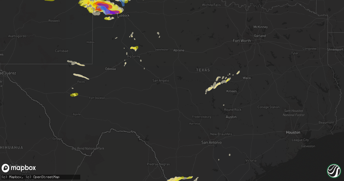
Hail Map in Texas on May 23, 2022
Get this storm
May 23 map
$229
one time, instant access
Download today. No call, no setup
Keep the $229
Bought the map and want the full workflow? Apply the entire $229 to a subscription within 7 days. None of it is wasted.
Every map, not just this one
This buys you this map. Subscription and you get every map we run, in the markets you choose from a few cities to whole states to nationwide. Plus real-time alerts the moment a storm fires.
Contact data
Name, contact info, occupancy, even credit band for addresses in the footprint. You go from where it hit to who to call.
Become the source they trust
Unlimited branding weather history reports on demand. You already have the documented answer ready for the property owner, and you are the one who showed up with it.
Property data and RoofTrace estimates
Pull up any address you have got, its value and the exact code rules for that jurisdiction, straight from One Click Code. Then RoofTrace estimates the squares, pitch, and roof value, priced the way you price.
Storm reports in Texas
Texas
| Date | Description |
|---|---|
| 05/23/20226:52 PM CDT | Social media photos and reports depict a brief tornado touchdown in an open field. Location estimated from radar. |
| 05/23/20226:50 PM CDT | A local report indicates 2.50 inch wind near 3 S BOVINA |
| 05/23/20226:36 PM CDT | A local report indicates 2.25 inch wind near 3 N MAPLE |
| 05/23/20226:33 PM CDT | A local report indicates 1.00 inch wind near BOVINA |
| 05/23/20226:17 PM CDT | A local report indicates 1.50 inch wind near 1 ESE MAPLE |
| 05/23/20225:45 PM CDT | A local report indicates 1.75 inch wind near 16 WNW MORTON |
| 05/23/20225:00 PM CDT | A local report indicates 1.50 inch wind near 9 ESE DALHART |
| 05/23/20224:53 PM CDT | A local report indicates 1.00 inch wind near 4 NNW HARTLEY |
| 05/23/20226:58 AM CDT | At 1157 PM CDT, severe thunderstorms were located along a line extending from near Lasara to near Lyford High School to Laguna Seca, moving east at 30 mph. HAZARD...60 mph wind gusts and quarter size hail. SOURCE...Radar indicated. IMPACT...Hail damage to vehicles is expected. Expect wind damage to roofs, siding, and trees. Locations impacted include... Harlingen, San Benito, Raymondville, La Feria, Elsa, Edcouch, Santa Rosa, Lyford, Rio Hondo and La Villa.This includes the following highways... Interstate Highway 69 E between mile markers 15 and 51. US Highway 77 between mile markers 758 and 762. US Highway 281 between mile markers 758 and 764. |
| 05/23/20226:38 AM CDT | At 1138 PM MDT, a severe thunderstorm was located near Arch, or 12 miles southeast of Portales, moving east at 20 mph. HAZARD...60 mph wind gusts and quarter size hail. SOURCE...Radar indicated. IMPACT...Hail damage to vehicles is expected. Expect wind damage to roofs, siding, and trees. Locations impacted include... Dora, Arch and Rogers. |
| 05/23/20226:34 AM CDT | At 1134 PM CDT, a severe thunderstorm was located 4 miles north of Maple, or 15 miles northwest of Morton, moving east at 25 mph. HAZARD...60 mph wind gusts and quarter size hail. SOURCE...Radar indicated. IMPACT...Hail damage to vehicles is expected. Expect wind damage to roofs, siding, and trees. Locations impacted include... Sudan, Needmore, Muleshoe Wildlife Refuge, Bula, Enochs, Pep and Maple. |
| 05/23/20226:09 AM CDT | At 1108 PM CDT, a severe thunderstorm was located near B.l. Garza Middle School, or near Faysville, moving east at 35 mph. HAZARD...Two inch hail and 70 mph wind gusts. SOURCE...Radar indicated. IMPACT...People and animals outdoors will be injured. Expect hail damage to roofs, siding, windows, and vehicles. Expect considerable tree damage. Wind damage is also likely to mobile homes, roofs, and outbuildings. Locations impacted include... Edinburg, Mercedes, Raymondville, Elsa, Edcouch, La Villa, Lasara, Linn, North McAllen and Hargill.This includes the following highways... Interstate Highway 69 E near mile marker 45, and between milemarkers 49 and 51. Interstate Highway 69 C between mile markers 3 and 12. US Highway 77 between mile markers 758 and 762. US Highway 281 between mile markers 752 and 764. |
| 05/23/20225:25 AM CDT | At 1025 PM CDT, a severe thunderstorm was located near Las Lomas, or near Garciasville, moving east at 35 mph. HAZARD...60 mph wind gusts and half dollar size hail. SOURCE...Radar indicated. IMPACT...Hail damage to vehicles is expected. Expect wind damage to roofs, siding, and trees. Locations impacted include... Mission, Rio Grande City, Palmview, Penitas, Sullivan City, La Joya, Palmhurst, Escobares, Garciasville and La Rosita.This includes US Highway 83 between mile markers 812 and 850. |
| 05/23/20225:24 AM CDT | At 1023 PM CDT, a severe thunderstorm was located near Santa Catarina, or 13 miles northwest of Mccook, moving east at 30 mph. HAZARD...Tennis ball size hail and 60 mph wind gusts. SOURCE...Radar indicated. IMPACT...People and animals outdoors will be injured. Expect hail damage to roofs, siding, windows, and vehicles. Expect wind damage to roofs, siding, and trees. Locations impacted include... Encino, Rachal, San Manuel, Mccook, Linn, Faysville, Puerto Rico, Red Gate, Santa Catarina and La Gloria.This includes the following highways... Interstate Highway 69 C between mile markers 10 and 12. US Highway 281 between mile markers 732 and 764. |
| 05/23/20224:58 AM CDT | At 958 PM CDT, a severe thunderstorm was located near Muleshoe, moving east at 25 mph. HAZARD...70 mph wind gusts and half dollar size hail. SOURCE...Radar indicated. IMPACT...Hail damage to vehicles is expected. Expect considerable tree damage. Wind damage is also likely to mobile homes, roofs, and outbuildings. Locations impacted include... Muleshoe, Needmore, Lazbuddie, Oklahoma Lane, Progress, Lariat and West Camp. |
| 05/23/20224:53 AM CDT | At 953 PM CDT, a severe thunderstorm was located 8 miles northwest of Reese Center, or 12 miles northeast of Levelland, moving east at 15 mph. HAZARD...60 mph wind gusts and quarter size hail. SOURCE...Radar indicated. IMPACT...Hail damage to vehicles is expected. Expect wind damage to roofs, siding, and trees. Locations impacted include... Lubbock, Shallowater, Anton, Lubbock International Airport, Texas Tech University, Downtown Lubbock, Reese Center, New Deal and Smyer. |
| 05/23/20224:39 AM CDT | At 939 PM CDT, a severe thunderstorm was located near Viboras, moving southeast at 30 mph. HAZARD...60 mph wind gusts and half dollar size hail. SOURCE...Radar indicated. IMPACT...Hail damage to vehicles is expected. Expect wind damage to roofs, siding, and trees. Locations impacted include... Rio Grande City, Roma, Escobares, Agua Nueva, El Sauz, Viboras, Garciasville, La Rosita, New Falcon and Los Alvarez.This includes US Highway 83 between mile markers 786 and 828. |
| 05/23/20224:27 AM CDT | At 927 PM CDT, a severe thunderstorm was located 4 miles south of Dimmitt, moving east at 25 mph. HAZARD...70 mph wind gusts and quarter size hail. SOURCE...Radar indicated. IMPACT...Hail damage to vehicles is expected. Expect considerable tree damage. Wind damage is also likely to mobile homes, roofs, and outbuildings. Locations impacted include... Dimmitt, Easter and Nazareth. |
| 05/23/20224:25 AM CDT | At 924 PM CDT, a severe thunderstorm was located near Guerra, or 14 miles west of Agua Nueva, moving east at 20 mph. HAZARD...Tennis ball size hail and 60 mph wind gusts. SOURCE...Radar indicated. IMPACT...People and animals outdoors will be injured. Expect hail damage to roofs, siding, windows, and vehicles. Expect wind damage to roofs, siding, and trees. Locations impacted include... Agua Nueva and Guerra. |
| 05/23/20224:22 AM CDT | Social media report of video showing mostly quarter size hail with a few ping pong size hail stones in palmview. |
| 05/23/20224:13 AM CDT | At 913 PM CDT, severe thunderstorms were located along a line extending from 3 miles northeast of Rhea to 3 miles west of Oklahoma Lane to 6 miles east of Arch, moving east at 40 mph. HAZARD...70 mph wind gusts and nickel size hail. SOURCE...Radar indicated. IMPACT...Expect considerable tree damage. Damage is likely to mobile homes, roofs, and outbuildings. Locations impacted include... Muleshoe, Friona, Bovina, Lazbuddie, Oklahoma Lane, Progress, Lariat, Rhea, West Camp and Black. |
| 05/23/20224:02 AM CDT | At 902 PM CDT, a severe thunderstorm was located near New Falcon, or 7 miles southeast of Lopeno, moving northeast at 20 mph. HAZARD...60 mph wind gusts and half dollar size hail. SOURCE...Radar indicated. IMPACT...Hail damage to vehicles is expected. Expect wind damage to roofs, siding, and trees. Locations impacted include... Viboras, Lopeno, Agua Nueva, El Sauz, New Falcon, Falcon Dam, Roma High School, Morales-Sanchez, Salineno and Falcon Heights.This includes US Highway 83 between mile markers 780 and 804. |
| 05/23/20223:57 AM CDT | At 856 PM CDT, a severe thunderstorm was located 7 miles west of Dimmitt, moving east at 25 mph. HAZARD...70 mph wind gusts and ping pong ball size hail. SOURCE...Radar indicated. IMPACT...People and animals outdoors will be injured. Expect hail damage to roofs, siding, windows, and vehicles. Expect considerable tree damage. Wind damage is also likely to mobile homes, roofs, and outbuildings. Locations impacted include... Dimmitt and Easter. |
| 05/23/20223:39 AM CDT | At 839 PM CDT, a severe thunderstorm was located near Randado, or 15 miles east of Bustamante, moving east at 15 mph. HAZARD...Tennis ball size hail and 60 mph wind gusts. SOURCE...Radar indicated. IMPACT...People and animals outdoors will be injured. Expect hail damage to roofs, siding, windows, and vehicles. Expect wind damage to roofs, siding, and trees. Locations impacted include... Zapata, Agua Nueva, Bustamante, Hebbronville, Medina, Zapata High School, Guerra, Zapata County Fire Department, Randado and Escobas.This includes US Highway 83 between mile markers 754 and 778. |
| 05/23/20223:39 AM CDT | At 839 PM CDT, a severe thunderstorm was located near Callaghan, or 7 miles south of Encinal, moving north at 20 mph. HAZARD...Ping pong ball size hail and 60 mph wind gusts. SOURCE...Radar indicated. IMPACT...People and animals outdoors will be injured. Expect hail damage to roofs, siding, windows, and vehicles. Expect wind damage to roofs, siding, and trees. Locations impacted include... Encinal and Callaghan. This includes the following highways... Interstate 35 between mile markers 25 and 47. US Highway 83 between mile markers 690 and 692. |
| 05/23/20223:29 AM CDT | At 828 PM CDT, a severe thunderstorm was located 8 miles southeast of Friona, moving northeast at 30 mph. HAZARD...60 mph wind gusts and quarter size hail. SOURCE...Radar indicated. IMPACT...Hail damage to vehicles is expected. Expect wind damage to roofs, siding, and trees. Locations impacted include... Black. |
| 05/23/20223:26 AM CDT | A local report indicates 58 MPH wind near 2 W CHILDRESS |
| 05/23/20223:07 AM CDT | At 806 PM CDT, a severe thunderstorm was located near Bustamante, moving east at 20 mph. HAZARD...Golf ball size hail and 60 mph wind gusts. SOURCE...Radar indicated. IMPACT...People and animals outdoors will be injured. Expect hail damage to roofs, siding, windows, and vehicles. Expect wind damage to roofs, siding, and trees. Locations impacted include... Zapata, Bustamante, Medina, Zapata High School, Guerra, Zapata County Fire Department, Randado, Escobas, Zapata Middle School and Siesta Shores.This includes US Highway 83 between mile markers 748 and 774. |
| 05/23/20222:57 AM CDT | At 757 PM CDT, a severe thunderstorm was located 10 miles northeast of Channing, or 14 miles west of Dumas, moving northeast at 45 mph. HAZARD...Quarter size hail. SOURCE...Radar indicated. IMPACT...Damage to vehicles is expected. Locations impacted include... Dumas, Cactus and Sunray. |
| 05/23/20222:54 AM CDT | At 754 PM CDT, a severe thunderstorm was located over Unitec Industrial Park, or 11 miles north of Laredo, moving northeast at 25 mph. HAZARD...60 mph wind gusts and quarter size hail. SOURCE...Radar indicated. IMPACT...Hail damage to vehicles is expected. Expect wind damage to roofs, siding, and trees. Locations impacted include... Laredo, Orvil, Botines, Unitec Industrial Park and Callaghan. This includes the following highways... Interstate 35 between mile markers 9 and 35. US Highway 83 between mile markers 690 and 698. |
| 05/23/20222:29 AM CDT | At 728 PM CDT, a severe thunderstorm was located 7 miles southeast of Friona, moving northeast at 15 mph. HAZARD...60 mph wind gusts and quarter size hail. SOURCE...Radar indicated. IMPACT...Hail damage to vehicles is expected. Expect wind damage to roofs, siding, and trees. Locations impacted include... Friona, Summerfield and Black. |
| 05/23/20222:28 AM CDT | At 727 PM CDT, a severe thunderstorm was located 13 miles north of Zapata County Airport, or 13 miles northwest of Bustamante, moving east at 35 mph. HAZARD...Golf ball size hail and 60 mph wind gusts. SOURCE...Radar indicated. IMPACT...People and animals outdoors will be injured. Expect hail damage to roofs, siding, windows, and vehicles. Expect wind damage to roofs, siding, and trees. Locations impacted include... Escobas.This includes US Highway 83 between mile markers 738 and 756. |
| 05/23/20222:25 AM CDT | At 723 PM CDT, a severe thunderstorm was located 8 miles west of Gatesville, moving northeast at 25 mph. HAZARD...Quarter size hail. SOURCE...Radar indicated. IMPACT...Damage to vehicles is possible. Locations impacted include... Ames and Turnersville. |
| 05/23/20222:18 AM CDT | Awos station knqi kingsville nas gusted to 54 knots. |
| 05/23/20222:13 AM CDT | At 713 PM CDT, a severe thunderstorm was located 6 miles northwest of Earth, moving north at 10 mph. HAZARD...60 mph wind gusts and quarter size hail. SOURCE...Radar indicated. IMPACT...Hail damage to vehicles is expected. Expect wind damage to roofs, siding, and trees. Locations impacted include... Dimmitt and Earth. |
| 05/23/20221:49 AM CDT | At 649 PM CDT, a severe thunderstorm was located over Balmorhea, or 20 miles south of Toyah, moving east at 5 mph. HAZARD...60 mph wind gusts and quarter size hail. SOURCE...Radar indicated. IMPACT...Hail damage to vehicles is expected. Expect wind damage to roofs, siding, and trees. Locations impacted include... Balmorhea, Balmorhea Lake, Balmorhea State Park, Saragosa, Verhalen and Toyahvale.This includes Interstate 10 between mile markers 203 and 226. |
| 05/23/20221:42 AM CDT | At 642 PM CDT, a severe thunderstorm was located 11 miles south of El Cenizo, or 22 miles northwest of Zapata, moving northeast at 30 mph. HAZARD...Ping pong ball size hail and 60 mph wind gusts. SOURCE...Radar indicated. IMPACT...People and animals outdoors will be injured. Expect hail damage to roofs, siding, windows, and vehicles. Expect wind damage to roofs, siding, and trees. This severe thunderstorm will remain over mainly rural areas of northern Zapata County.This includes US Highway 83 between mile markers 738 and 748. |
| 05/23/20221:39 AM CDT | At 639 PM CDT, a severe thunderstorm was located near Chaparral Wildlife Management Area, or 13 miles north of Encinal, moving east at 30 mph. HAZARD...60 mph wind gusts and quarter size hail. SOURCE...Radar indicated. IMPACT...Hail damage to vehicles is expected. Expect wind damage to roofs, siding, and trees. Locations impacted include... Artesia Wells and Chaparral Wildlife Management Area. This includes Interstate 35 between mile markers 48 and 61. |
| 05/23/20221:39 AM CDT | At 638 PM CDT, severe thunderstorms were located along a line extending from 4 miles south of Progress to 3 miles northeast of Needmore to 3 miles west of Morton, moving northeast at 25 mph. HAZARD...Two inch hail and 60 mph wind gusts. SOURCE...Trained weather spotters reported two inch diameter hail 3 miles north of Maple at 638 PM CDT. IMPACT...People and animals outdoors will be injured. Expect hail damage to roofs, siding, windows, and vehicles. Expect wind damage to roofs, siding, and trees. Locations impacted include... Muleshoe, Earth, Sudan, Amherst, Needmore, Muleshoe Wildlife Refuge, Bula, Enochs and Maple. |
| 05/23/20221:33 AM CDT | At 633 PM CDT, a severe thunderstorm was located near Luther, or 14 miles east of Ackerly, moving northwest at 15 mph. HAZARD...60 mph wind gusts and half dollar size hail. SOURCE...Radar indicated. IMPACT...Hail damage to vehicles is expected. Expect wind damage to roofs, siding, and trees. Locations impacted include... Ackerly, Luther and Vealmoor. |
| 05/23/20221:25 AM CDT | At 625 PM CDT, a severe thunderstorm was located over Bovina, or 13 miles southwest of Friona, moving east at 15 mph. HAZARD...Ping pong ball size hail and 60 mph wind gusts. SOURCE...Radar indicated. IMPACT...People and animals outdoors will be injured. Expect hail damage to roofs, siding, windows, and vehicles. Expect wind damage to roofs, siding, and trees. Locations impacted include... Friona, Bovina, Farwell, Black and Rhea. |
| 05/23/20221:14 AM CDT | At 613 PM CDT, a severe thunderstorm was located 8 miles south of Catarina, or 20 miles northwest of Encinal, moving east at 25 mph. HAZARD...60 mph wind gusts and quarter size hail. SOURCE...Radar indicated. IMPACT...Hail damage to vehicles is expected. Expect wind damage to roofs, siding, and trees. Locations impacted include... Light and Chaparral Wildlife Management Area. |
| 05/23/20221:08 AM CDT | At 608 PM CDT, a severe thunderstorm was located 14 miles north of Oilton, or 23 miles southwest of Freer, moving northeast at 20 mph. HAZARD...Ping pong ball size hail and 60 mph wind gusts. SOURCE...Radar indicated. IMPACT...People and animals outdoors will be injured. Expect hail damage to roofs, siding, windows, and vehicles. Expect wind damage to roofs, siding, and trees. This severe thunderstorm will remain over mainly rural areas of west central Duval and east central Webb Counties.This includes US Highway 59 between mile markers 776 and 788. |
| 05/23/20221:02 AM CDT | At 602 PM CDT, a severe thunderstorm was located 8 miles south of Gilson Groves, or 23 miles west of Encinal, moving east at 30 mph. HAZARD...60 mph wind gusts and half dollar size hail. SOURCE...Radar indicated. IMPACT...Hail damage to vehicles is expected. Expect wind damage to roofs, siding, and trees. This severe thunderstorm will remain over mainly rural areas of north central Webb County.This includes US Highway 83 between mile markers 668 and 672. |
| 05/23/202212:44 AM CDT | At 544 PM CDT, a severe thunderstorm was located 6 miles east of Bellview, or 18 miles northwest of Friona, moving northeast at 30 mph. HAZARD...60 mph wind gusts and quarter size hail. SOURCE...Radar indicated. IMPACT...Minor damage to roofs, siding, and trees is possible. Hail damage to vehicles is expected. Locations impacted include... Hereford, Simms and Bootleg. |
| 05/23/202212:42 AM CDT | West texas mesonet |
| 05/23/202212:29 AM CDT | At 529 PM CDT, a severe thunderstorm was located 8 miles southeast of Chupadera Ranch Airport, or 29 miles south of Carrizo Springs, moving east at 20 mph. HAZARD...60 mph wind gusts and quarter size hail. SOURCE...Radar indicated. IMPACT...Hail damage to vehicles is expected. Expect wind damage to roofs, siding, and trees. This severe thunderstorm will remain over mainly rural areas of northwestern Webb County. |
| 05/23/202212:28 AM CDT | At 528 PM CDT, a severe thunderstorm was located over Clovis, moving northeast at 25 mph. HAZARD...60 mph wind gusts and quarter size hail. SOURCE...Radar indicated. IMPACT...Hail damage to vehicles is expected. Expect wind damage to roofs, siding, and trees. Locations impacted include... Friona, Bovina, Farwell, Black and Rhea. |
| 05/22/202211:44 PM CDT | At 444 PM MDT, a severe thunderstorm was located near Causey, or 20 miles southeast of Portales, moving northeast at 20 mph. HAZARD...60 mph wind gusts and quarter size hail. SOURCE...Radar indicated. IMPACT...Hail damage to vehicles is expected. Expect wind damage to roofs, siding, and trees. Locations impacted include... Causey. |
| 05/22/202211:43 PM CDT | At 443 PM MDT, a severe thunderstorm was located 8 miles north of Texico, or 10 miles northeast of Clovis, moving northeast at 35 mph. HAZARD...60 mph wind gusts and quarter size hail. SOURCE...Trained weather spotters. IMPACT...Hail damage to vehicles is expected. Expect wind damage to roofs, siding, and trees. Locations impacted include... Clovis, Texico, Ranchvale, Bellview and Pleasant Hill. This includes Highway 60 between Mile Markers 384 and 397. |
| 05/22/202211:42 PM CDT | At 441 PM CDT, a severe thunderstorm was located 5 miles southwest of Hartley, or 15 miles south of Dalhart, moving northeast at 45 mph. HAZARD...Quarter size hail. SOURCE...Radar indicated. IMPACT...Damage to vehicles is expected. Locations impacted include... Dalhart, Hartley, Cactus and Conlen. |
| 05/22/202211:20 PM CDT | Segovia unit prison north of edinburg reported a roof blown off prison building. Estimated wind speed 60 to 70 mph based on radar. Time estimated 1115 to 1145 pm. |
| 05/22/202211:14 PM CDT | Lamb county sheriff's office reported power lines down on county road 167. Time estimated from radar. |
| 05/22/202211:01 PM CDT | At 401 PM MDT, a severe thunderstorm was located over Pep, or 23 miles south of Portales, moving northeast at 25 mph. HAZARD...60 mph wind gusts and half dollar size hail. SOURCE...Radar indicated. IMPACT...Hail damage to vehicles is expected. Expect wind damage to roofs, siding, and trees. Locations impacted include... Dora, Causey, Arch, Pep and Rogers. |
| 05/22/202211:00 PM CDT | Social media report of tree down near highway 69 and davis rd. |
| 05/22/202210:58 PM CDT | At 358 PM MDT, a severe thunderstorm was located near Cannon Air Force Base, or near Clovis, moving northeast at 40 mph. HAZARD...60 mph wind gusts and quarter size hail. SOURCE...Radar indicated. IMPACT...Hail damage to vehicles is expected. Expect wind damage to roofs, siding, and trees. Locations impacted include... Clovis, Farwell, Texico, Cannon Air Force Base, Portair and Pleasant Hill.This includes Highway 60 between Mile Markers 378 and 397. |
| 05/22/202210:42 PM CDT | Barn damaged |
| 05/22/202210:05 PM CDT | West texas mesonet |
| 05/22/20229:59 PM CDT | 2 to 3 inches of accumulated quarter-sized hail on the ground. |
| 05/22/20229:53 PM CDT | Power poles snapped. |
| 05/22/20229:51 PM CDT | Power poles blown down at the intersection of fm 597 and fm 303. |
| 05/22/20229:49 PM CDT | A local report indicates 1.00 inch wind near 4 W SHALLOWATER |
| 05/22/20229:28 PM CDT | A local report indicates 1.75 inch wind near 2 NE LEVELLAND |
| 05/22/20229:05 PM CDT | Ping pong ball sized hail reported southeast of encinal. |
| 05/22/20228:45 PM CDT | A local report indicates a tornado near 11 NW LEVELLAND |
| 05/22/20228:38 PM CDT | West texas mesonet. |
| 05/22/20228:34 PM CDT | Quarter size hail at mile marker 26 along i-35. |
| 05/22/20228:25 PM CDT | At 124 PM CDT, a severe thunderstorm was located 9 miles southeast of Greenwood, moving northeast at 20 mph. HAZARD...60 mph wind gusts and quarter size hail. SOURCE...Radar indicated. IMPACT...Hail damage to vehicles is expected. Expect wind damage to roofs, siding, and trees. Locations impacted include... Big Spring, Stanton, Forsan, Lomax, Big Spring Country Club, Big Spring McMahon-Wrinkle Airpark, Knott, Elbow and Spraberry.This includes Interstate 20 between mile markers 158 and 180. |
| 05/22/20228:20 PM CDT | Fire department employee reports estimated quarter size hail. |
| 05/22/20228:07 PM CDT | Social media video of tornado touching down in open field. |
| 05/22/20227:47 PM CDT | West texas mesonet. 40 mph sustained winds also observed. |
| 05/22/20227:07 PM CDT | Large tornado reported by off-duty nws employee. |
All States Impacted by Hail Map on May 23, 2022
Cities Impacted by Hail Map on May 23, 2022
- Gillett, TX
- Karnes City, TX
- Runge, TX
- Tulia, TX
- Farwell, TX
- Hephzibah, GA
- Augusta, GA
- Clayton, NC
- Wendell, NC
- Gatesville, TX
- Jonesboro, TX
- Channing, TX
- Texline, TX
- Dalhart, TX
- Fort Sumner, NM
- Blythe, GA
- Keysville, GA
- Purmela, TX
- Mebane, NC
- Efland, NC
- Hillsborough, NC
- Welch, TX
- Levelland, TX
- Ropesville, TX
- Plainview, TX
- Dumas, TX
- Louisville, GA
- Wrens, GA
- Rio Grande City, TX
- Garciasville, TX
- Mosquero, NM
- Newington, GA
- Cache, OK
- Statesboro, GA
- Sylvania, GA
- Jasper, FL
- Live Oak, FL
- White Springs, FL
- Claxton, GA
- Glennville, GA
- Laredo, TX
- Pecos, TX
- Pyote, TX
- Littlefield, TX
- Wolfforth, TX
- Balmorhea, TX
- Gail, TX
- Big Spring, TX
- Evant, TX
- Lometa, TX
- Lampasas, TX
- Falls City, TX
- Bainbridge, GA
- Brinson, GA
- San Ygnacio, TX
- Zapata, TX
- Hartley, TX
- Rotan, TX
- Zebulon, NC
- Sardis, GA
- Millen, GA
- Garfield, GA
- Girard, GA
- Rocky Ford, GA
- Stratford, TX
- Swainsboro, GA
- Lyons, GA
- Valdosta, GA
- Moody Afb, GA
- Hahira, GA
- Lakeland, GA
- Ray City, GA
- Bear Creek, NC
- Sanford, NC
- Goldston, NC
- Holly Springs, NC
- Cary, NC
- Apex, NC
- New Hill, NC
- Friona, TX
- Texico, NM
- Fairfax, SC
- Hale Center, TX
- Gruver, TX
- East Dublin, GA
- San Saba, TX
- Cherokee, TX
- Bamberg, SC
- Olar, SC
- Ulmer, SC
- Floydada, TX
- Lockney, TX
- Maysville, NC
- Williston, SC
- Barnwell, SC
- Lenorah, TX
- Ehrhardt, SC
- Jacksonville, NC
- Richlands, NC
- Rio Hondo, TX
- Encinal, TX
- Asherton, TX
- Carrizo Springs, TX
- Cotulla, TX
- Raymondville, TX
- Hargill, TX
- Edcouch, TX
- Lyford, TX
- Lawton, OK
- Garden City, TX
- Wedgefield, SC
- Eastover, SC
- Swansea, SC
- North, SC
- Saint Matthews, SC
- Hopkins, SC
- Gadsden, SC
- Dexter, GA
- Cochran, GA
- Dudley, GA
- Chester, GA
- Buffalo, SD
- Camilla, GA
- Barstow, TX
- Homerville, GA
- Dimmitt, TX
- Dublin, GA
- Portales, NM
- Sundown, TX
- Marlow, OK
- Blackville, SC
- Sterling City, TX
- Midland, TX
- Hamilton, TX
- Jayton, TX
- North Fort Myers, FL
- Grulla, TX
- Edinburg, TX
- Mission, TX
- Santa Elena, TX
- San Isidro, TX
- Linn, TX
- Roma, TX
- Guerra, TX
- Hebbronville, TX
- Delmita, TX
- Hobart, OK
- Abbeville, GA
- Stanton, TX
- Nazareth, TX
- Lake City, FL
- Rogers, NM
- Pep, NM
- Clovis, NM
- Cannon Afb, NM
- Nashville, GA
- Valley Mills, TX
- Amherst, TX
- Morton, TX
- Sudan, TX
- Pep, TX
- Elida, NM
- Enochs, TX
- Maple, TX
- Shallowater, TX
- Anton, TX
- Lubbock, TX
- Muleshoe, TX
- Causey, NM
- Star, TX
- Goldthwaite, TX
- Springlake, TX
- Earth, TX
- Fieldton, TX
- Olton, TX
- Bovina, TX
- Penitas, TX
- La Joya, TX
- Mcallen, TX
- Metter, GA
- Liberty Hill, TX
- Millwood, GA
- Axson, GA
- Petersburg, TX
- Hereford, TX
- Abernathy, TX
- Eastman, GA
- Jal, NM
- Cobbtown, GA
- Collins, GA
- Cairo, GA
- Thomasville, GA
- Mentone, TX
- Loving, NM
- Kinston, NC
- Deep Run, NC
- Coahoma, TX
- Yeso, NM
- Roswell, NM
- Milnesand, NM
- Monetta, SC
- Ridge Spring, SC
- Batesburg, SC
- Edgefield, SC
- Saluda, SC
- Lexington, SC
- Clarks Hill, SC
- Gilbert, SC
- Ward, SC
- Grovetown, GA
- Leesville, SC
- Trenton, SC
- Johnston, SC
- North Augusta, SC
- Evans, GA
- Warrenville, SC
- Jackson, SC
- Beech Island, SC
- Brooklet, GA
- Clyo, GA
- Register, GA
- Guyton, GA
- Springfield, GA
- Pembroke, GA
- Ellabell, GA
- Fort Stewart, GA
- Chesnee, SC
- Boiling Springs, SC
- Concord, NC
- Harrisburg, NC
- Charlotte, NC
- Durham, NC


