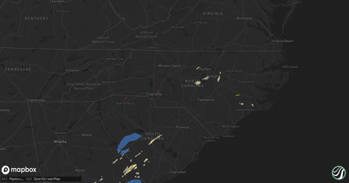
Hail Map in North Carolina on May 23, 2022
Get this storm
May 23 map
$229
one time, instant access
Download today. No call, no setup
Keep the $229
Bought the map and want the full workflow? Apply the entire $229 to a subscription within 7 days. None of it is wasted.
Every map, not just this one
This buys you this map. Subscription and you get every map we run, in the markets you choose from a few cities to whole states to nationwide. Plus real-time alerts the moment a storm fires.
Contact data
Name, contact info, occupancy, even credit band for addresses in the footprint. You go from where it hit to who to call.
Become the source they trust
Unlimited branding weather history reports on demand. You already have the documented answer ready for the property owner, and you are the one who showed up with it.
Property data and RoofTrace estimates
Pull up any address you have got, its value and the exact code rules for that jurisdiction, straight from One Click Code. Then RoofTrace estimates the squares, pitch, and roof value, priced the way you price.
Storm reports in North Carolina
North Carolina
| Date | Description |
|---|---|
| 05/23/20226:25 PM CDT | Broadcast media reported trees down and damage to house. |
| 05/23/20225:05 PM CDT | Craven county 911 relayed report of trees down near the intersection of camelot dr. And north ridge rd. In james city. Time based on radar. |
| 05/23/20224:33 PM CDT | Public reported nickel to quarter sized hail. Time based on radar. |
| 05/23/20224:24 PM CDT | Public reported at least quarter size hail lasting for about 15 minutes. Time based on radar. |
| 05/23/20224:23 PM CDT | Large pine tree snapped as well as other large limbs down on bland howell rd. |
| 05/23/20224:22 PM CDT | Public reports power pole snapped along bland howell rd. Time based on radar. |
| 05/23/20224:22 PM CDT | Law enforcement relayed report of damage to a structure along hwy 55 near moss hill. Time based on radar. |
| 05/23/20224:10 PM CDT | Damage to an out building smith grady road. |
| 05/23/20224:08 PM CDT | A severe thunderstorm produced a microburst as it moved across strabane in southwestern lenoir county. The intense winds began in an open field just west of smith-grady |
| 05/23/20223:45 PM CDT | Numerous trees and power-lines down throughout the county. |
| 05/23/20223:30 PM CDT | 911 center reports 1 tree down near old nc highway 86 and blanch rd extension. Time estimated from radar. |
| 05/23/20223:23 PM CDT | Tree down on power line. |
| 05/23/20223:23 PM CDT | 911 center reports 1 tree down on red marshall rd. Time estimated from radar. |
| 05/23/20223:16 PM CDT | Fallen trees on power equipment. |
| 05/23/20223:14 PM CDT | Trees down on power lines. |
| 05/23/20223:10 PM CDT | Numerous trees down throughout the county... Including downed trees on homes. |
| 05/23/20223:10 PM CDT | 911 center reports 2 trees down near intersection of mary jane bigelow rd and burton chapel rd. Time estimated from radar. |
| 05/23/20223:05 PM CDT | Trees down in northgate park neighborhood north of downtown durham. Time estimated by radar. |
| 05/23/20223:04 PM CDT | Numerous trees snapped along highway 70 near laurel dr. |
| 05/23/20222:46 PM CDT | Downed trees on power equipment and lines. |
| 05/23/20222:40 PM CDT | Tree down at nc highway 54 w and stanford rd. |
| 05/23/20222:34 PM CDT | Tree down at efland-cedar grove rd and us highway 70 w. |
| 05/23/20222:32 PM CDT | Tree blown down near the intersection of carthage st and carbonton rd. Time estimated by radar. |
| 05/23/20222:29 PM CDT | Tree blown down at the intersection of mciver st and 7th street in sanford. |
| 05/23/20222:25 PM CDT | Trees and power lines down on deep river road. |
| 05/23/20222:10 PM CDT | Two trees down blocking the roadway near glendon carthage road and s carbonton road. Time estimated by radar. |
| 05/23/20222:08 PM CDT | One tree down blocking the roadway near the intersection of freeman road and branch road. Time estimated by radar. |
| 05/23/20221:57 PM CDT | One tree down near the intersection of murdocksville road and juniper lake road. Time estimated by radar. |
| 05/23/20221:55 PM CDT | Tree down on house on e lindale dr in robbins. Multiple other trees down in the robbins area. |
| 05/23/20221:53 PM CDT | Two trees blown down along with large limbs near the intersection of jackson creek rd and parker mill rd near martha. |
| 05/23/20221:50 PM CDT | Trees uprooted or snapped; roof blown off. Time estimated by radar. |
| 05/23/20221:45 PM CDT | Trees blown down. Time estimated by radar. |
| 05/23/20221:30 PM CDT | Tree down on okeewemee rd near nc highway 134-n in troy. |
| 05/23/202212:55 PM CDT | Stanly county 911 reports numerous trees down county-wide. |
| 05/23/202212:52 PM CDT | Broadcast media reported large tree limbs down and a truck tipped over by possible tornado on mulberry rd |
| 05/23/202212:48 PM CDT | Trees and power lines down on rocky river road. Possible tornado. |
| 05/23/202212:43 PM CDT | Trees down near piccadilly lane. Possible tornado. |
| 05/23/202212:37 PM CDT | Trained spotter reported trees snapped and uprooted on hood rd. |
| 05/23/202212:20 PM CDT | Trees and power lines down along burnt umber drive. Possible tornado. |
| 05/23/202212:51 AM CDT | At 550 PM EDT, a severe thunderstorm was located near Fort Barnwell, or 12 miles east of Kinston, moving east at 25 mph. HAZARD...60 mph wind gusts and quarter size hail. SOURCE...Radar indicated. IMPACT...Hail damage to vehicles is expected. Expect wind damage to roofs, siding, and trees. Locations impacted include... New Bern, Washington, James City, Trent Woods, River Bend, Grifton, Blounts Creek, Vanceboro, Askins, Cayton, Shelmerdine, Calico, Fort Barnwell, Jasper, Tuscarora, Rhems, Wilmar, Cox Crossroads, Wyse Fork and Ernul. |
| 05/23/202212:15 AM CDT | At 515 PM EDT, a severe thunderstorm was located near Deep Run, or near Kinston, moving east at 25 mph. HAZARD...60 mph wind gusts and quarter size hail. SOURCE...Radar indicated. IMPACT...Hail damage to vehicles is expected. Expect wind damage to roofs, siding, and trees. Locations impacted include... Kinston, Grifton, Deep Run, Fort Barnwell, Dawson, Graingers, Wyse Fork, Kinston Regional Jetport, Dover, Sandy Bottom and Cove City. |
| 05/23/202212:14 AM CDT | At 513 PM EDT, a severe thunderstorm was located near Catfish Lake, or 11 miles west of Havelock, moving east at 20 mph. HAZARD...60 mph wind gusts and quarter size hail. SOURCE...Radar indicated. IMPACT...Hail damage to vehicles is expected. Expect wind damage to roofs, siding, and trees. Locations impacted include... New Bern, Havelock, Morehead City, Newport, Harlowe, Croatan, Kuhns, North Harlowe, Catfish Lake, Neuse Forest, Cherry Branch Ferry Terminal and Crab Point Village. |
| 05/23/202212:05 AM CDT | At 505 PM EDT, severe thunderstorms were located along a line extending from 9 miles east of Louisburg to 8 miles southwest of Nashville, moving northeast at 35 mph. HAZARD...60 mph wind gusts. SOURCE...Radar indicated. IMPACT...Expect damage to roofs, siding, and trees. Locations impacted include... Rocky Mount, Roanoke Rapids, Nashville, Halifax, Dortches, Red Oak, Enfield, Weldon, Spring Hope and Whitakers. |
| 05/22/202211:34 PM CDT | At 434 PM EDT, severe thunderstorms were located along a line extending from 6 miles northwest of Franklinton to 6 miles southeast of Wake Forest, moving northeast at 40 mph. HAZARD...60 mph wind gusts. SOURCE...Trained weather spotters. IMPACT...Expect damage to roofs, siding, and trees. Locations impacted include... Henderson, Louisburg, Franklinton, Kittrell, Bunn, Spring Hope, Youngsville, Middlesex, Castalia and Centerville. |
| 05/22/202211:05 PM CDT | At 405 PM EDT, severe thunderstorms were located along a line extending from RDU International to 7 miles northeast of Angier, moving east at 40 mph. HAZARD...60 mph wind gusts. SOURCE...Radar indicated. IMPACT...Expect damage to roofs, siding, and trees. Locations impacted include... Raleigh, Smithfield, Wake Forest, Clayton, Zebulon, Knightdale, Micro, Selma, Wendell and Rolesville. |
| 05/22/202211:00 PM CDT | At 400 PM EDT, a severe thunderstorm was located over Petersburg, or 8 miles north of Half Moon, moving east at 15 mph. HAZARD...60 mph wind gusts and quarter size hail. SOURCE...Radar indicated. IMPACT...Hail damage to vehicles is expected. Expect wind damage to roofs, siding, and trees. Locations impacted include... Jacksonville, Richlands, Maysville, Comfort, Belgrade, Petersburg, Richlands South, Deppe, Loco VFD and Trenton. |
| 05/22/202210:57 PM CDT | At 356 PM EDT, a severe thunderstorm was located near Durham, moving northeast at 40 mph. HAZARD...60 mph wind gusts. SOURCE...Radar indicated. IMPACT...Expect damage to roofs, siding, and trees. Locations impacted include... Raleigh, Durham, Creedmoor, Wake Forest, Butner, RDU International, Morrisville, Falls Lake State Rec Area, Gorman and Falls Lake. |
| 05/22/202210:33 PM CDT | At 333 PM EDT, a severe thunderstorm was located 7 miles northeast of Sanford, moving northeast at 30 mph. HAZARD...60 mph wind gusts. SOURCE...Radar indicated. IMPACT...Expect damage to roofs, siding, and trees. Locations impacted include... Raleigh, Cary, Garner, Fuquay-Varina, Apex, Holly Springs, Morrisville, New Hill, Lake Wheeler and Raven Rock State Park. |
| 05/22/202210:23 PM CDT | At 323 PM EDT, severe thunderstorms were located along a line extending from near Siler City to near Goldston to near Sanford, moving northeast at 35 mph. HAZARD...60 mph wind gusts. SOURCE...Radar indicated. IMPACT...Expect damage to roofs, siding, and trees. Locations impacted include... Durham, Chapel Hill, Sanford, Pittsboro, Carrboro, Crosswinds Boating Center, Snow Camp, Crosswinds Campground, Parkwood and Sutphin. |
| 05/22/202210:18 PM CDT | At 317 PM EDT, a severe thunderstorm was located near Graham, moving northeast at 20 mph. HAZARD...60 mph wind gusts and quarter size hail. SOURCE...Radar indicated. IMPACT...Hail damage to vehicles is expected. Expect wind damage to roofs, siding, and trees. Locations impacted include... Jericho... Prospect Hill... Leasburg... Topnot... Hightowers... Baynes... and Hyco Lake. |
| 05/22/202210:13 PM CDT | At 312 PM EDT, a severe thunderstorm was located near Mebane, or near Graham, moving east at 20 mph. HAZARD...60 mph wind gusts and quarter size hail. SOURCE...Radar indicated. IMPACT...Hail damage to vehicles is expected. Expect wind damage to roofs, siding, and trees. This severe thunderstorm will be near... Mebane around 315 PM EDT. Hillsborough around 340 PM EDT.Other locations impacted by this severe thunderstorm include Carr,Efland, Alamance, Eno River State Park and Lake Burlington. |
| 05/22/20229:26 PM CDT | At 226 PM EDT, severe thunderstorms were located along a line extending from 11 miles southeast of High Rock Lake to 7 miles east of Badin Lake to 10 miles south of Troy, moving northeast at 40 mph. HAZARD...60 mph wind gusts. SOURCE...Radar indicated. IMPACT...Expect damage to roofs, siding, and trees. Locations impacted include... High Point, Asheboro, Lexington, Randleman, Siler City, North Carolina Zoo, Thomasville, Biscoe, Goldston and Seagrove. |
All States Impacted by Hail Map on May 23, 2022
Cities Impacted by Hail Map on May 23, 2022
- Gillett, TX
- Karnes City, TX
- Runge, TX
- Tulia, TX
- Farwell, TX
- Hephzibah, GA
- Augusta, GA
- Clayton, NC
- Wendell, NC
- Gatesville, TX
- Jonesboro, TX
- Channing, TX
- Texline, TX
- Dalhart, TX
- Fort Sumner, NM
- Blythe, GA
- Keysville, GA
- Purmela, TX
- Mebane, NC
- Efland, NC
- Hillsborough, NC
- Welch, TX
- Levelland, TX
- Ropesville, TX
- Plainview, TX
- Dumas, TX
- Louisville, GA
- Wrens, GA
- Rio Grande City, TX
- Garciasville, TX
- Mosquero, NM
- Newington, GA
- Cache, OK
- Statesboro, GA
- Sylvania, GA
- Jasper, FL
- Live Oak, FL
- White Springs, FL
- Claxton, GA
- Glennville, GA
- Laredo, TX
- Pecos, TX
- Pyote, TX
- Littlefield, TX
- Wolfforth, TX
- Balmorhea, TX
- Gail, TX
- Big Spring, TX
- Evant, TX
- Lometa, TX
- Lampasas, TX
- Falls City, TX
- Bainbridge, GA
- Brinson, GA
- San Ygnacio, TX
- Zapata, TX
- Hartley, TX
- Rotan, TX
- Zebulon, NC
- Sardis, GA
- Millen, GA
- Garfield, GA
- Girard, GA
- Rocky Ford, GA
- Stratford, TX
- Swainsboro, GA
- Lyons, GA
- Valdosta, GA
- Moody Afb, GA
- Hahira, GA
- Lakeland, GA
- Ray City, GA
- Bear Creek, NC
- Sanford, NC
- Goldston, NC
- Holly Springs, NC
- Cary, NC
- Apex, NC
- New Hill, NC
- Friona, TX
- Texico, NM
- Fairfax, SC
- Hale Center, TX
- Gruver, TX
- East Dublin, GA
- San Saba, TX
- Cherokee, TX
- Bamberg, SC
- Olar, SC
- Ulmer, SC
- Floydada, TX
- Lockney, TX
- Maysville, NC
- Williston, SC
- Barnwell, SC
- Lenorah, TX
- Ehrhardt, SC
- Jacksonville, NC
- Richlands, NC
- Rio Hondo, TX
- Encinal, TX
- Asherton, TX
- Carrizo Springs, TX
- Cotulla, TX
- Raymondville, TX
- Hargill, TX
- Edcouch, TX
- Lyford, TX
- Lawton, OK
- Garden City, TX
- Wedgefield, SC
- Eastover, SC
- Swansea, SC
- North, SC
- Saint Matthews, SC
- Hopkins, SC
- Gadsden, SC
- Dexter, GA
- Cochran, GA
- Dudley, GA
- Chester, GA
- Buffalo, SD
- Camilla, GA
- Barstow, TX
- Homerville, GA
- Dimmitt, TX
- Dublin, GA
- Portales, NM
- Sundown, TX
- Marlow, OK
- Blackville, SC
- Sterling City, TX
- Midland, TX
- Hamilton, TX
- Jayton, TX
- North Fort Myers, FL
- Grulla, TX
- Edinburg, TX
- Mission, TX
- Santa Elena, TX
- San Isidro, TX
- Linn, TX
- Roma, TX
- Guerra, TX
- Hebbronville, TX
- Delmita, TX
- Hobart, OK
- Abbeville, GA
- Stanton, TX
- Nazareth, TX
- Lake City, FL
- Rogers, NM
- Pep, NM
- Clovis, NM
- Cannon Afb, NM
- Nashville, GA
- Valley Mills, TX
- Amherst, TX
- Morton, TX
- Sudan, TX
- Pep, TX
- Elida, NM
- Enochs, TX
- Maple, TX
- Shallowater, TX
- Anton, TX
- Lubbock, TX
- Muleshoe, TX
- Causey, NM
- Star, TX
- Goldthwaite, TX
- Springlake, TX
- Earth, TX
- Fieldton, TX
- Olton, TX
- Bovina, TX
- Penitas, TX
- La Joya, TX
- Mcallen, TX
- Metter, GA
- Liberty Hill, TX
- Millwood, GA
- Axson, GA
- Petersburg, TX
- Hereford, TX
- Abernathy, TX
- Eastman, GA
- Jal, NM
- Cobbtown, GA
- Collins, GA
- Cairo, GA
- Thomasville, GA
- Mentone, TX
- Loving, NM
- Kinston, NC
- Deep Run, NC
- Coahoma, TX
- Yeso, NM
- Roswell, NM
- Milnesand, NM
- Monetta, SC
- Ridge Spring, SC
- Batesburg, SC
- Edgefield, SC
- Saluda, SC
- Lexington, SC
- Clarks Hill, SC
- Gilbert, SC
- Ward, SC
- Grovetown, GA
- Leesville, SC
- Trenton, SC
- Johnston, SC
- North Augusta, SC
- Evans, GA
- Warrenville, SC
- Jackson, SC
- Beech Island, SC
- Brooklet, GA
- Clyo, GA
- Register, GA
- Guyton, GA
- Springfield, GA
- Pembroke, GA
- Ellabell, GA
- Fort Stewart, GA
- Chesnee, SC
- Boiling Springs, SC
- Concord, NC
- Harrisburg, NC
- Charlotte, NC
- Durham, NC


