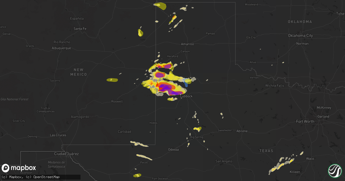
Hail Map on May 23, 2022
Get this storm
May 23 map
$229
one time, instant access
Download today. No call, no setup
Keep the $229
Bought the map and want the full workflow? Apply the entire $229 to a subscription within 7 days. None of it is wasted.
Every map, not just this one
This buys you this map. Subscription and you get every map we run, in the markets you choose from a few cities to whole states to nationwide. Plus real-time alerts the moment a storm fires.
Contact data
Name, contact info, occupancy, even credit band for addresses in the footprint. You go from where it hit to who to call.
Become the source they trust
Unlimited branding weather history reports on demand. You already have the documented answer ready for the property owner, and you are the one who showed up with it.
Property data and RoofTrace estimates
Pull up any address you have got, its value and the exact code rules for that jurisdiction, straight from One Click Code. Then RoofTrace estimates the squares, pitch, and roof value, priced the way you price.
States Impacted by Hail Map on May 23, 2022
Storm reports
North Carolina
| Date | Description |
|---|---|
| 05/23/20226:25 PM CDT | Broadcast media reported trees down and damage to house. |
| 05/23/20225:05 PM CDT | Craven county 911 relayed report of trees down near the intersection of camelot dr. And north ridge rd. In james city. Time based on radar. |
| 05/23/20224:33 PM CDT | Public reported nickel to quarter sized hail. Time based on radar. |
| 05/23/20224:24 PM CDT | Public reported at least quarter size hail lasting for about 15 minutes. Time based on radar. |
| 05/23/20224:23 PM CDT | Large pine tree snapped as well as other large limbs down on bland howell rd. |
| 05/23/20224:22 PM CDT | Public reports power pole snapped along bland howell rd. Time based on radar. |
| 05/23/20224:22 PM CDT | Law enforcement relayed report of damage to a structure along hwy 55 near moss hill. Time based on radar. |
| 05/23/20224:10 PM CDT | Damage to an out building smith grady road. |
| 05/23/20224:08 PM CDT | A severe thunderstorm produced a microburst as it moved across strabane in southwestern lenoir county. The intense winds began in an open field just west of smith-grady |
| 05/23/20223:45 PM CDT | Numerous trees and power-lines down throughout the county. |
| 05/23/20223:30 PM CDT | 911 center reports 1 tree down near old nc highway 86 and blanch rd extension. Time estimated from radar. |
| 05/23/20223:23 PM CDT | Tree down on power line. |
| 05/23/20223:23 PM CDT | 911 center reports 1 tree down on red marshall rd. Time estimated from radar. |
| 05/23/20223:16 PM CDT | Fallen trees on power equipment. |
| 05/23/20223:14 PM CDT | Trees down on power lines. |
| 05/23/20223:10 PM CDT | 911 center reports 2 trees down near intersection of mary jane bigelow rd and burton chapel rd. Time estimated from radar. |
| 05/23/20223:10 PM CDT | Numerous trees down throughout the county... Including downed trees on homes. |
| 05/23/20223:05 PM CDT | Trees down in northgate park neighborhood north of downtown durham. Time estimated by radar. |
| 05/23/20223:04 PM CDT | Numerous trees snapped along highway 70 near laurel dr. |
| 05/23/20222:46 PM CDT | Downed trees on power equipment and lines. |
| 05/23/20222:40 PM CDT | Tree down at nc highway 54 w and stanford rd. |
| 05/23/20222:34 PM CDT | Tree down at efland-cedar grove rd and us highway 70 w. |
| 05/23/20222:32 PM CDT | Tree blown down near the intersection of carthage st and carbonton rd. Time estimated by radar. |
| 05/23/20222:29 PM CDT | Tree blown down at the intersection of mciver st and 7th street in sanford. |
| 05/23/20222:25 PM CDT | Trees and power lines down on deep river road. |
| 05/23/20222:10 PM CDT | Two trees down blocking the roadway near glendon carthage road and s carbonton road. Time estimated by radar. |
| 05/23/20222:08 PM CDT | One tree down blocking the roadway near the intersection of freeman road and branch road. Time estimated by radar. |
| 05/23/20221:57 PM CDT | One tree down near the intersection of murdocksville road and juniper lake road. Time estimated by radar. |
| 05/23/20221:55 PM CDT | Tree down on house on e lindale dr in robbins. Multiple other trees down in the robbins area. |
| 05/23/20221:53 PM CDT | Two trees blown down along with large limbs near the intersection of jackson creek rd and parker mill rd near martha. |
| 05/23/20221:50 PM CDT | Trees uprooted or snapped; roof blown off. Time estimated by radar. |
| 05/23/20221:45 PM CDT | Trees blown down. Time estimated by radar. |
| 05/23/20221:30 PM CDT | Tree down on okeewemee rd near nc highway 134-n in troy. |
| 05/23/202212:55 PM CDT | Stanly county 911 reports numerous trees down county-wide. |
| 05/23/202212:52 PM CDT | Broadcast media reported large tree limbs down and a truck tipped over by possible tornado on mulberry rd |
| 05/23/202212:48 PM CDT | Trees and power lines down on rocky river road. Possible tornado. |
| 05/23/202212:43 PM CDT | Trees down near piccadilly lane. Possible tornado. |
| 05/23/202212:37 PM CDT | Trained spotter reported trees snapped and uprooted on hood rd. |
| 05/23/202212:20 PM CDT | Trees and power lines down along burnt umber drive. Possible tornado. |
| 05/23/202212:51 AM CDT | At 550 PM EDT, a severe thunderstorm was located near Fort Barnwell, or 12 miles east of Kinston, moving east at 25 mph. HAZARD...60 mph wind gusts and quarter size hail. SOURCE...Radar indicated. IMPACT...Hail damage to vehicles is expected. Expect wind damage to roofs, siding, and trees. Locations impacted include... New Bern, Washington, James City, Trent Woods, River Bend, Grifton, Blounts Creek, Vanceboro, Askins, Cayton, Shelmerdine, Calico, Fort Barnwell, Jasper, Tuscarora, Rhems, Wilmar, Cox Crossroads, Wyse Fork and Ernul. |
| 05/23/202212:15 AM CDT | At 515 PM EDT, a severe thunderstorm was located near Deep Run, or near Kinston, moving east at 25 mph. HAZARD...60 mph wind gusts and quarter size hail. SOURCE...Radar indicated. IMPACT...Hail damage to vehicles is expected. Expect wind damage to roofs, siding, and trees. Locations impacted include... Kinston, Grifton, Deep Run, Fort Barnwell, Dawson, Graingers, Wyse Fork, Kinston Regional Jetport, Dover, Sandy Bottom and Cove City. |
| 05/23/202212:14 AM CDT | At 513 PM EDT, a severe thunderstorm was located near Catfish Lake, or 11 miles west of Havelock, moving east at 20 mph. HAZARD...60 mph wind gusts and quarter size hail. SOURCE...Radar indicated. IMPACT...Hail damage to vehicles is expected. Expect wind damage to roofs, siding, and trees. Locations impacted include... New Bern, Havelock, Morehead City, Newport, Harlowe, Croatan, Kuhns, North Harlowe, Catfish Lake, Neuse Forest, Cherry Branch Ferry Terminal and Crab Point Village. |
| 05/23/202212:05 AM CDT | At 505 PM EDT, severe thunderstorms were located along a line extending from 9 miles east of Louisburg to 8 miles southwest of Nashville, moving northeast at 35 mph. HAZARD...60 mph wind gusts. SOURCE...Radar indicated. IMPACT...Expect damage to roofs, siding, and trees. Locations impacted include... Rocky Mount, Roanoke Rapids, Nashville, Halifax, Dortches, Red Oak, Enfield, Weldon, Spring Hope and Whitakers. |
| 05/22/202211:34 PM CDT | At 434 PM EDT, severe thunderstorms were located along a line extending from 6 miles northwest of Franklinton to 6 miles southeast of Wake Forest, moving northeast at 40 mph. HAZARD...60 mph wind gusts. SOURCE...Trained weather spotters. IMPACT...Expect damage to roofs, siding, and trees. Locations impacted include... Henderson, Louisburg, Franklinton, Kittrell, Bunn, Spring Hope, Youngsville, Middlesex, Castalia and Centerville. |
| 05/22/202211:05 PM CDT | At 405 PM EDT, severe thunderstorms were located along a line extending from RDU International to 7 miles northeast of Angier, moving east at 40 mph. HAZARD...60 mph wind gusts. SOURCE...Radar indicated. IMPACT...Expect damage to roofs, siding, and trees. Locations impacted include... Raleigh, Smithfield, Wake Forest, Clayton, Zebulon, Knightdale, Micro, Selma, Wendell and Rolesville. |
| 05/22/202211:00 PM CDT | At 400 PM EDT, a severe thunderstorm was located over Petersburg, or 8 miles north of Half Moon, moving east at 15 mph. HAZARD...60 mph wind gusts and quarter size hail. SOURCE...Radar indicated. IMPACT...Hail damage to vehicles is expected. Expect wind damage to roofs, siding, and trees. Locations impacted include... Jacksonville, Richlands, Maysville, Comfort, Belgrade, Petersburg, Richlands South, Deppe, Loco VFD and Trenton. |
| 05/22/202210:57 PM CDT | At 356 PM EDT, a severe thunderstorm was located near Durham, moving northeast at 40 mph. HAZARD...60 mph wind gusts. SOURCE...Radar indicated. IMPACT...Expect damage to roofs, siding, and trees. Locations impacted include... Raleigh, Durham, Creedmoor, Wake Forest, Butner, RDU International, Morrisville, Falls Lake State Rec Area, Gorman and Falls Lake. |
| 05/22/202210:33 PM CDT | At 333 PM EDT, a severe thunderstorm was located 7 miles northeast of Sanford, moving northeast at 30 mph. HAZARD...60 mph wind gusts. SOURCE...Radar indicated. IMPACT...Expect damage to roofs, siding, and trees. Locations impacted include... Raleigh, Cary, Garner, Fuquay-Varina, Apex, Holly Springs, Morrisville, New Hill, Lake Wheeler and Raven Rock State Park. |
| 05/22/202210:23 PM CDT | At 323 PM EDT, severe thunderstorms were located along a line extending from near Siler City to near Goldston to near Sanford, moving northeast at 35 mph. HAZARD...60 mph wind gusts. SOURCE...Radar indicated. IMPACT...Expect damage to roofs, siding, and trees. Locations impacted include... Durham, Chapel Hill, Sanford, Pittsboro, Carrboro, Crosswinds Boating Center, Snow Camp, Crosswinds Campground, Parkwood and Sutphin. |
| 05/22/202210:18 PM CDT | At 317 PM EDT, a severe thunderstorm was located near Graham, moving northeast at 20 mph. HAZARD...60 mph wind gusts and quarter size hail. SOURCE...Radar indicated. IMPACT...Hail damage to vehicles is expected. Expect wind damage to roofs, siding, and trees. Locations impacted include... Jericho... Prospect Hill... Leasburg... Topnot... Hightowers... Baynes... and Hyco Lake. |
| 05/22/202210:13 PM CDT | At 312 PM EDT, a severe thunderstorm was located near Mebane, or near Graham, moving east at 20 mph. HAZARD...60 mph wind gusts and quarter size hail. SOURCE...Radar indicated. IMPACT...Hail damage to vehicles is expected. Expect wind damage to roofs, siding, and trees. This severe thunderstorm will be near... Mebane around 315 PM EDT. Hillsborough around 340 PM EDT.Other locations impacted by this severe thunderstorm include Carr,Efland, Alamance, Eno River State Park and Lake Burlington. |
| 05/22/20229:26 PM CDT | At 226 PM EDT, severe thunderstorms were located along a line extending from 11 miles southeast of High Rock Lake to 7 miles east of Badin Lake to 10 miles south of Troy, moving northeast at 40 mph. HAZARD...60 mph wind gusts. SOURCE...Radar indicated. IMPACT...Expect damage to roofs, siding, and trees. Locations impacted include... High Point, Asheboro, Lexington, Randleman, Siler City, North Carolina Zoo, Thomasville, Biscoe, Goldston and Seagrove. |
New Mexico
| Date | Description |
|---|---|
| 05/23/20226:18 PM CDT | Video of estimated quarter size hail in clayton via twitter. |
| 05/23/20225:54 PM CDT | From brandon at fire and rescue. |
| 05/23/20225:41 PM CDT | Report from mping: golf ball |
| 05/23/20225:39 PM CDT | Report from mping: quarter |
| 05/23/20225:25 PM CDT | Hail covered the ground. |
| 05/23/20225:10 PM CDT | Covering ground... Marbles up to quarter in size. |
| 05/23/20225:42 AM CDT | At 1042 PM CDT, a severe thunderstorm was located 7 miles north of Sudan, or 9 miles southwest of Earth, moving east at 25 mph. HAZARD...60 mph wind gusts and quarter size hail. SOURCE...Radar indicated. IMPACT...Hail damage to vehicles is expected. Expect wind damage to roofs, siding, and trees. Locations impacted include... Muleshoe, Earth, Sudan, Amherst, Needmore, Progress, Lariat, Muleshoe Wildlife Refuge, West Camp and Springlake. |
| 05/23/20224:01 AM CDT | At 901 PM MDT, a severe thunderstorm was located 18 miles northwest of Ute Lake State Park, or 21 miles southeast of Mosquero, moving southeast at 5 mph. HAZARD...60 mph wind gusts and quarter size hail. SOURCE...Radar indicated. IMPACT...Hail damage to vehicles is expected. Expect wind damage to roofs, siding, and trees. This severe thunderstorm will remain over mainly rural areas of southeastern Harding County. |
| 05/23/20223:00 AM CDT | At 759 PM MDT, a severe thunderstorm was located near Clovis, moving east at 20 mph. HAZARD...60 mph wind gusts and quarter size hail. SOURCE...Radar indicated. IMPACT...Hail damage to vehicles is expected. Expect wind damage to roofs, siding, and trees. Locations impacted include... Clovis, Farwell, Texico, Cannon Air Force Base, Arch, Portair and Pleasant Hill.This includes Highway 60 between Mile Markers 382 and 397. |
| 05/23/202212:49 AM CDT | At 548 PM MDT, a severe thunderstorm was located near Mesa, or 39 miles southwest of Fort Sumner, moving northeast at 20 mph. HAZARD...60 mph wind gusts and quarter size hail. SOURCE...Radar indicated. IMPACT...Hail damage to vehicles is expected. Expect wind damage to roofs, siding, and trees. This severe thunderstorm will remain over mainly rural areas of southwestern De Baca County.This includes Highway 285 between Mile Markers 155 and 166. |
| 05/23/202212:46 AM CDT | At 545 PM CDT, a severe thunderstorm was located 6 miles east of Causey, or 16 miles northwest of Morton, moving northeast at 30 mph. HAZARD...60 mph wind gusts and quarter size hail. SOURCE...Radar indicated. IMPACT...Hail damage to vehicles is expected. Expect wind damage to roofs, siding, and trees. Locations impacted include... Muleshoe, Morton, Needmore, Enochs, Maple and Muleshoe Wildlife Refuge. |
Florida
| Date | Description |
|---|---|
| 05/23/20224:00 PM CDT | 8 to 9 trees down just to the east of suwannee springs. Time is estimated by radar imagery. |
| 05/23/20222:40 PM CDT | Tree down along hwy 69. |
| 05/23/20222:20 PM CDT | Tree down near u.s. Hwy 90. |
| 05/23/20222:20 PM CDT | Trees down near hwy 73 and hasty pond rd. |
| 05/23/20222:05 PM CDT | Trees on powerline in alford at park rd and arizona street. |
| 05/23/20222:02 PM CDT | Tree down along hwy 231 south of alford. |
| 05/23/202212:28 AM CDT | At 528 PM EDT, a severe thunderstorm was located near White Springs, moving northeast at 15 mph. HAZARD...60 mph wind gusts and nickel size hail. SOURCE...Radar indicated. IMPACT...Expect damage to roofs, siding, and trees. Locations impacted include... White Springs. |
| 05/22/202211:53 PM CDT | At 453 PM EDT, a severe thunderstorm was located over Suwannee Springs, moving east at 10 mph. HAZARD...60 mph wind gusts and nickel size hail. SOURCE...Radar indicated. IMPACT...Expect damage to roofs, siding, and trees. Locations impacted include... Suwannee Springs. |
| 05/22/202210:13 PM CDT | At 312 PM EDT, a severe thunderstorm was located 11 miles southwest of Midway, moving northeast at 35 mph. HAZARD...60 mph wind gusts. SOURCE...Radar indicated. IMPACT...Expect damage to roofs, siding, and trees. Locations impacted include... Tallahassee, Midway, Havana, Florida A And M, Tallahassee Comm College, Florida State University, Doak Campbell Stadium, Lake Bradford, Ralford Greenway, Macon Community Park, Gaither Community Center, Lake Munson, Tallahassee Memorial Hosp, Scotland, Killearn Estates, Lake Ella, Tallahassee Mall, Bloxham, Tallahassee Regional A/P and State Capital Complex. |
| 05/22/20229:48 PM CDT | At 248 PM EDT, a severe thunderstorm was located 18 miles southeast of Blountstown, moving northeast at 25 mph. HAZARD...60 mph wind gusts. SOURCE...Radar indicated. IMPACT...Expect damage to roofs, siding, and trees. Locations impacted include... Telogia, Bloxham and Clio. |
Maryland
| Date | Description |
|---|---|
| 05/23/202211:21 AM CDT | Several tree branches down along east franklin ave |
South Carolina
| Date | Description |
|---|---|
| 05/23/20226:54 PM CDT | Tree down near the intersection of harristown road and mendel rivers road. Time estimated based on radar. |
| 05/23/20226:15 PM CDT | Corrects previous tornado report from 1 sw chesnee. Radar indicated tds and confirmation from spartanburg county communications of funnel cloud. |
| 05/23/20226:15 PM CDT | Broadcast media reported several large trees down including one on a house. Half dozen buildings destroyed... One house with roof blown off. |
| 05/23/20226:14 PM CDT | Corrects previous tstm wnd dmg report from 3 w mayo. Broadcast media reported large tree down on power lines on the intersection of sandy ford and paris bridge road. |
| 05/23/20225:55 PM CDT | Dorcheser county 911 dispatch reported a tree was blown down across quaker road in saint george. A motorist had a collision with the tree as it fell. The driver was not |
| 05/23/20225:45 PM CDT | 911 call center reported trees down on catawba river rd |
| 05/23/20225:45 PM CDT | 911 call center reported trees and powerlines down. |
| 05/23/20225:45 PM CDT | Highway patrol reported a tree in the roadway near the intersection of hwy. 78... North road... And kennerly road. |
| 05/23/20225:41 PM CDT | Tree down near the intersection of benton farm road and hudson mill road. Time estimated based on radar. |
| 05/23/20225:40 PM CDT | 911 call center reported several trees down on dewitt and golf course road. |
| 05/23/20225:35 PM CDT | Trees down along i-95 near exit 42. |
| 05/23/20225:33 PM CDT | Trees down near the intersection of lowcountry highway and school house road. Time estimated based on radar. |
| 05/23/20225:33 PM CDT | Tree down near the intersection of sc-63 and us-21. Time estimated based on radar. |
| 05/23/20225:33 PM CDT | Tree down near the intersecton of red root road and deliverance road. Time estimated based on radar. |
| 05/23/20225:21 PM CDT | Tree down near the intersection of grays highway and gillison branch road. Time estimated based on radar. |
| 05/23/20225:15 PM CDT | Radar indicated tds and confirmation from spartanburg county communications of funnel cloud. |
| 05/23/20225:15 PM CDT | Trees blocking two lanes of browninggate road between chocolate city road and two sisters road. Time estimated based on radar. |
| 05/23/20225:14 PM CDT | Broadcast media reported large tree down on power lines on the intersection of sandy ford and paris bridge road. |
| 05/23/20225:12 PM CDT | Tree down near the intersection of sc-3 and johnie peeples dr. Time estimated based on radar. |
| 05/23/20225:10 PM CDT | Sc dot reported several trees down in the area of clear pond rd... Orange grove rd... And ehrhardt rd. Time estimated. |
| 05/23/20225:05 PM CDT | Tree down near the intersetion of tye branch road and richard pollins road. Time estimated based on radar. |
| 05/23/20225:03 PM CDT | Tree down near the intersection of honey hill road and steep bottom road. Time estimated based on radar. |
| 05/23/20224:55 PM CDT | Tree down near the intersection of shirley road and augusta stagecoach road. Time estimated based on radar. |
| 05/23/20224:47 PM CDT | Highway patrol reported a tree down in the roadway and blocked at hwy. 176 and new hope road near pomaria. |
| 05/23/20224:44 PM CDT | Sheriff dispatch reported a large tree down along state park road near aiken state park. |
| 05/23/20221:49 PM CDT | Sheriff dispatch reported trees down on a powerline along hummingbird road near great circle drive. |
| 05/23/20221:45 PM CDT | Public reported hail that began as pea size and increased in size up to nickel to quarter size before ending. The location was along big beaver creek road betweeen i-26 |
| 05/23/202211:00 AM CDT | 3 trees down on first street. |
| 05/23/202210:58 AM CDT | Highway patrol reported a tree down near the intersection of hwy. 176 and parr road. |
| 05/23/202210:52 AM CDT | 1 tree reported down as the storm came through. |
| 05/23/202210:48 AM CDT | Highway patrol reported a tree down near the intersection of macedonia church road and stockman road. |
| 05/23/202210:26 AM CDT | Sheriff dispatch reported a tree fell on a vehicle near the intersection of shiloh heights road and pipeline road. No injuries reported. |
| 05/23/202210:01 AM CDT | Sheriff dispatch reported a tree down at the intersection of woodward lake road and mount zion road. |
| 05/23/20226:30 AM CDT | At 1130 AM EDT, a severe thunderstorm was located near Ridge Spring, or near Batesburg-Leesville, moving northeast at 40 mph. HAZARD...60 mph wind gusts and penny size hail. SOURCE...Radar indicated. IMPACT...Expect damage to trees and powerlines. Locations impacted include... Lexington, Irmo, Batesburg-Leesville, Highway 6 at Lake Murray Dam, Ridge Spring, Saluda County Airport, Dreher Island State Park, Chapin, Gilbert, Summit, Little Mountain, Monetta, Pomaria, Ward, Cedar Grove Fire Station, South Shore Marina, Oswald Park, Saluda Co Sheriff's Office, Bundrick Island and Putnam's Landing.This includes Interstate 26 between mile markers 83 and 92. |
| 05/23/20226:16 AM CDT | At 1116 AM EDT, a severe thunderstorm was located 12 miles northeast of Laurens, or 8 miles north of Clinton, moving northeast at 45 mph. HAZARD...60 mph wind gusts. SOURCE...Radar indicated. IMPACT...Expect damage to trees and power lines. Locations impacted include... Gaffney, Union, Pacolet, Blacksburg, Buffalo, Jonesville, Pacolet Mills, Hickory Grove, Smyrna and Croft State Park. |
| 05/23/20226:03 AM CDT | At 1102 AM EDT, a severe thunderstorm was located near Edgefield County Airport, or 9 miles northeast of Belvedere, moving northeast at 35 mph. HAZARD...60 mph wind gusts and penny size hail. SOURCE...Radar indicated. IMPACT...Expect damage to trees and powerlines. Locations impacted include... Aiken, Batesburg-Leesville, Aiken Mall, Edgefield, Saluda, Johnston, Ridge Spring, USC Aiken, Saluda County Airport, Edgefield County Airport, Citizens Park, Aiken Municipal Airport, Graniteville, Gloverville, Wagener, Monetta, Trenton, Ward, Strom Thurmond High School and Saluda Co Sheriff's Office.This includes Interstate 20 in South Carolina between mile markers 11and 36. |
| 05/23/20225:40 AM CDT | At 1039 AM EDT, a severe thunderstorm was located over Fort Gordon, moving northeast at 35 mph. HAZARD...60 mph wind gusts and penny size hail. SOURCE...Radar indicated. IMPACT...Expect damage to trees and powerlines. Locations impacted include... Aiken, North Augusta, Grovetown, Evans, Martinez, Fort Gordon, Augusta, Clearwater, Belvedere, Edgefield, Hephzibah, Glendale, South Augusta, Midtown, Riverwood, Summerville, Augusta Mall, Daniel Field, Village Plaza Shopping Center and Augusta National Golf Club.This includes the following highways... Interstate 20 in Georgia between mile markers 184 and 201. Interstate 20 in South Carolina between mile markers 0 and 13. Interstate 520 in Georgia between mile markers 1 and 15. Interstate 520 in South Carolina between mile markers 16 and 23. |
| 05/23/20222:06 AM CDT | At 705 PM EDT, severe thunderstorms were located along a line extending from near Holly Hill to 7 miles southwest of Dorchester to White Hall, moving east at 40 mph. HAZARD...60 mph wind gusts. SOURCE...Radar indicated. IMPACT...Expect damage to trees and powerlines. These thunderstorms have a history of scattered tree damage. Locations impacted include: North Charleston, Summerville, Goose Creek, Moncks Corner, Givhans Ferry State Park, Ladson, Dorchester, Ridgeville, Saint Stephen, Cottageville, Harleyville, Bonneau, Jamestown, Givhans and Cross.This warning includes the following interstates: I-26 between mile markers 171 and 204. I-95 in South Carolina near mile marker 85. |
| 05/23/20221:26 AM CDT | At 626 PM EDT, severe thunderstorms were located along a line extending from Lodge to Gillisonville, moving northeast at 40 mph. HAZARD...60 mph wind gusts. SOURCE...Radar indicated. IMPACT...Expect damage to trees and powerlines. Locations impacted include: Walterboro, Saint George, Yemassee, Colleton, Varnville, Cottageville, Reevesville, Smoaks, Lodge, Williams, Ruffin, Miley, Grays, Ashton and Hendersonville.This warning includes I-95 in South Carolina between mile markers 35and 82. |
| 05/23/20221:06 AM CDT | At 605 PM EDT, severe thunderstorms were located along a line extending from near Ellabell to McIntosh to near Tibet, moving northeast at 40 mph. HAZARD...60 mph wind gusts and penny size hail. SOURCE...Radar indicated. IMPACT...Expect damage to trees and powerlines. Locations impacted include: Hinesville, Pooler, Bluffton, Richmond Hill, Tybee Island, Darien, Tibet, Bellinger Hill Area, Savannah International Airport, Fort Stewart, Wilmington Island, Fort Pulaski National Monument, Midtown Savannah, Downtown Savannah and Coffee Bluff.This warning includes the following interstates: I-16 between mile markers 147 and 168. I-516 between mile markers 3 and 9. I-95 in South Carolina between mile markers 2 and 10. I-95 in Georgia between mile markers 50 and 112. |
| 05/23/202212:53 AM CDT | At 552 PM EDT, a severe thunderstorm was located 7 miles south of Denmark, moving northeast at 20 mph. HAZARD...60 mph wind gusts and nickel size hail. SOURCE...Radar indicated. IMPACT...Expect damage to trees and powerlines. Locations impacted include... Bamberg, Denmark, Olar, Govan and Bamberg County Airport. |
| 05/22/202211:47 PM CDT | At 447 PM EDT, severe thunderstorms were located along a line extending from near Perkins to near Surrency, moving east at 15 mph. HAZARD...60 mph wind gusts and penny size hail. SOURCE...Radar indicated. IMPACT...Expect damage to trees and powerlines. Locations impacted include: Hinesville, Statesboro, Reidsville, Metter, Glennville, Millen, Sylvania, Claxton, Pembroke, Ludowici, Fort Stewart, Butts, Brooklet, Hagan and Portal.This warning includes I-16 between mile markers 96 and 135. |
| 05/22/20229:43 PM CDT | At 242 PM EDT, a severe thunderstorm was located near Sandy Run, or 11 miles southwest of McEntire Air Base, moving northeast at 40 mph. HAZARD...60 mph wind gusts and half dollar size hail. SOURCE...Radar indicated. IMPACT...Hail damage to vehicles is expected. Expect wind damage to trees and powerlines. Locations impacted include... Columbia, McEntire Air Base, Eastover, Congaree National Park, Hopkins, Sandy Run, Gadsden, Poinsett State Park, Horrel Hill, Fort Motte, Wedgewood, Fort Jackson McCrady Training Center and Stateburg.This includes Interstate 26 between mile markers 124 and 137. |
| 05/22/20229:32 PM CDT | At 231 PM EDT, severe thunderstorms were located along a line extending from 13 miles south of Biscoe to near Hamlet to near Cheraw State Park, moving northeast at 35 mph. HAZARD...60 mph wind gusts. SOURCE...Radar indicated. IMPACT...Expect damage to roofs, siding, and trees. Locations impacted include... Laurinburg, Southern Pines, Rockingham, Raeford, Carthage, Pinehurst, Hamlet, Aberdeen, Maxton and Hoffman. |
| 05/22/20228:44 PM CDT | At 144 PM EDT, severe thunderstorms were located along a line extending from near Midland to near Sturdivants, moving northeast at 40 mph. HAZARD...60 mph wind gusts. SOURCE...Radar indicated. IMPACT...Expect damage to roofs, siding, and trees. Locations impacted include... Albemarle, Rockingham, Wadesboro, Troy, Badin Lake, Hamlet, Ansonville, Plyler, Polkton and Locust. |
| 05/22/20227:20 PM CDT | Two mature loblolly pine trees snapped in moore farms botanical garden. Time estimated via radar. |
Alabama
| Date | Description |
|---|---|
| 05/22/202210:48 PM CDT | At 347 PM EDT/247 PM CDT/, severe thunderstorms were located along a line extending from 11 miles east of Cottonwood to 6 miles southwest of Donalsonville to 6 miles north of Chattahoochee, moving northeast at 35 mph. HAZARD...60 mph wind gusts. SOURCE...Radar indicated. IMPACT...Expect damage to roofs, siding, and trees. Locations impacted include... Colquitt, Bainbridge, Donalsonville, West Bainbridge, Chattahoochee, Malone, Iron City, Brinson, Jakin, Hanover, Saffold, Ausmac, Babcock, Reynoldsville, Crosby, Little Hope, Recovery, Mayhaw, Decatur Co A/P and Boykin. |
Texas
| Date | Description |
|---|---|
| 05/23/20226:52 PM CDT | Social media photos and reports depict a brief tornado touchdown in an open field. Location estimated from radar. |
| 05/23/20226:50 PM CDT | A local report indicates 2.50 inch wind near 3 S BOVINA |
| 05/23/20226:36 PM CDT | A local report indicates 2.25 inch wind near 3 N MAPLE |
| 05/23/20226:33 PM CDT | A local report indicates 1.00 inch wind near BOVINA |
| 05/23/20226:17 PM CDT | A local report indicates 1.50 inch wind near 1 ESE MAPLE |
| 05/23/20225:45 PM CDT | A local report indicates 1.75 inch wind near 16 WNW MORTON |
| 05/23/20225:00 PM CDT | A local report indicates 1.50 inch wind near 9 ESE DALHART |
| 05/23/20224:53 PM CDT | A local report indicates 1.00 inch wind near 4 NNW HARTLEY |
| 05/23/20226:58 AM CDT | At 1157 PM CDT, severe thunderstorms were located along a line extending from near Lasara to near Lyford High School to Laguna Seca, moving east at 30 mph. HAZARD...60 mph wind gusts and quarter size hail. SOURCE...Radar indicated. IMPACT...Hail damage to vehicles is expected. Expect wind damage to roofs, siding, and trees. Locations impacted include... Harlingen, San Benito, Raymondville, La Feria, Elsa, Edcouch, Santa Rosa, Lyford, Rio Hondo and La Villa.This includes the following highways... Interstate Highway 69 E between mile markers 15 and 51. US Highway 77 between mile markers 758 and 762. US Highway 281 between mile markers 758 and 764. |
| 05/23/20226:38 AM CDT | At 1138 PM MDT, a severe thunderstorm was located near Arch, or 12 miles southeast of Portales, moving east at 20 mph. HAZARD...60 mph wind gusts and quarter size hail. SOURCE...Radar indicated. IMPACT...Hail damage to vehicles is expected. Expect wind damage to roofs, siding, and trees. Locations impacted include... Dora, Arch and Rogers. |
| 05/23/20226:34 AM CDT | At 1134 PM CDT, a severe thunderstorm was located 4 miles north of Maple, or 15 miles northwest of Morton, moving east at 25 mph. HAZARD...60 mph wind gusts and quarter size hail. SOURCE...Radar indicated. IMPACT...Hail damage to vehicles is expected. Expect wind damage to roofs, siding, and trees. Locations impacted include... Sudan, Needmore, Muleshoe Wildlife Refuge, Bula, Enochs, Pep and Maple. |
| 05/23/20226:09 AM CDT | At 1108 PM CDT, a severe thunderstorm was located near B.l. Garza Middle School, or near Faysville, moving east at 35 mph. HAZARD...Two inch hail and 70 mph wind gusts. SOURCE...Radar indicated. IMPACT...People and animals outdoors will be injured. Expect hail damage to roofs, siding, windows, and vehicles. Expect considerable tree damage. Wind damage is also likely to mobile homes, roofs, and outbuildings. Locations impacted include... Edinburg, Mercedes, Raymondville, Elsa, Edcouch, La Villa, Lasara, Linn, North McAllen and Hargill.This includes the following highways... Interstate Highway 69 E near mile marker 45, and between milemarkers 49 and 51. Interstate Highway 69 C between mile markers 3 and 12. US Highway 77 between mile markers 758 and 762. US Highway 281 between mile markers 752 and 764. |
| 05/23/20225:25 AM CDT | At 1025 PM CDT, a severe thunderstorm was located near Las Lomas, or near Garciasville, moving east at 35 mph. HAZARD...60 mph wind gusts and half dollar size hail. SOURCE...Radar indicated. IMPACT...Hail damage to vehicles is expected. Expect wind damage to roofs, siding, and trees. Locations impacted include... Mission, Rio Grande City, Palmview, Penitas, Sullivan City, La Joya, Palmhurst, Escobares, Garciasville and La Rosita.This includes US Highway 83 between mile markers 812 and 850. |
| 05/23/20225:24 AM CDT | At 1023 PM CDT, a severe thunderstorm was located near Santa Catarina, or 13 miles northwest of Mccook, moving east at 30 mph. HAZARD...Tennis ball size hail and 60 mph wind gusts. SOURCE...Radar indicated. IMPACT...People and animals outdoors will be injured. Expect hail damage to roofs, siding, windows, and vehicles. Expect wind damage to roofs, siding, and trees. Locations impacted include... Encino, Rachal, San Manuel, Mccook, Linn, Faysville, Puerto Rico, Red Gate, Santa Catarina and La Gloria.This includes the following highways... Interstate Highway 69 C between mile markers 10 and 12. US Highway 281 between mile markers 732 and 764. |
| 05/23/20224:58 AM CDT | At 958 PM CDT, a severe thunderstorm was located near Muleshoe, moving east at 25 mph. HAZARD...70 mph wind gusts and half dollar size hail. SOURCE...Radar indicated. IMPACT...Hail damage to vehicles is expected. Expect considerable tree damage. Wind damage is also likely to mobile homes, roofs, and outbuildings. Locations impacted include... Muleshoe, Needmore, Lazbuddie, Oklahoma Lane, Progress, Lariat and West Camp. |
| 05/23/20224:53 AM CDT | At 953 PM CDT, a severe thunderstorm was located 8 miles northwest of Reese Center, or 12 miles northeast of Levelland, moving east at 15 mph. HAZARD...60 mph wind gusts and quarter size hail. SOURCE...Radar indicated. IMPACT...Hail damage to vehicles is expected. Expect wind damage to roofs, siding, and trees. Locations impacted include... Lubbock, Shallowater, Anton, Lubbock International Airport, Texas Tech University, Downtown Lubbock, Reese Center, New Deal and Smyer. |
| 05/23/20224:39 AM CDT | At 939 PM CDT, a severe thunderstorm was located near Viboras, moving southeast at 30 mph. HAZARD...60 mph wind gusts and half dollar size hail. SOURCE...Radar indicated. IMPACT...Hail damage to vehicles is expected. Expect wind damage to roofs, siding, and trees. Locations impacted include... Rio Grande City, Roma, Escobares, Agua Nueva, El Sauz, Viboras, Garciasville, La Rosita, New Falcon and Los Alvarez.This includes US Highway 83 between mile markers 786 and 828. |
| 05/23/20224:27 AM CDT | At 927 PM CDT, a severe thunderstorm was located 4 miles south of Dimmitt, moving east at 25 mph. HAZARD...70 mph wind gusts and quarter size hail. SOURCE...Radar indicated. IMPACT...Hail damage to vehicles is expected. Expect considerable tree damage. Wind damage is also likely to mobile homes, roofs, and outbuildings. Locations impacted include... Dimmitt, Easter and Nazareth. |
| 05/23/20224:25 AM CDT | At 924 PM CDT, a severe thunderstorm was located near Guerra, or 14 miles west of Agua Nueva, moving east at 20 mph. HAZARD...Tennis ball size hail and 60 mph wind gusts. SOURCE...Radar indicated. IMPACT...People and animals outdoors will be injured. Expect hail damage to roofs, siding, windows, and vehicles. Expect wind damage to roofs, siding, and trees. Locations impacted include... Agua Nueva and Guerra. |
| 05/23/20224:22 AM CDT | Social media report of video showing mostly quarter size hail with a few ping pong size hail stones in palmview. |
| 05/23/20224:13 AM CDT | At 913 PM CDT, severe thunderstorms were located along a line extending from 3 miles northeast of Rhea to 3 miles west of Oklahoma Lane to 6 miles east of Arch, moving east at 40 mph. HAZARD...70 mph wind gusts and nickel size hail. SOURCE...Radar indicated. IMPACT...Expect considerable tree damage. Damage is likely to mobile homes, roofs, and outbuildings. Locations impacted include... Muleshoe, Friona, Bovina, Lazbuddie, Oklahoma Lane, Progress, Lariat, Rhea, West Camp and Black. |
| 05/23/20224:02 AM CDT | At 902 PM CDT, a severe thunderstorm was located near New Falcon, or 7 miles southeast of Lopeno, moving northeast at 20 mph. HAZARD...60 mph wind gusts and half dollar size hail. SOURCE...Radar indicated. IMPACT...Hail damage to vehicles is expected. Expect wind damage to roofs, siding, and trees. Locations impacted include... Viboras, Lopeno, Agua Nueva, El Sauz, New Falcon, Falcon Dam, Roma High School, Morales-Sanchez, Salineno and Falcon Heights.This includes US Highway 83 between mile markers 780 and 804. |
| 05/23/20223:57 AM CDT | At 856 PM CDT, a severe thunderstorm was located 7 miles west of Dimmitt, moving east at 25 mph. HAZARD...70 mph wind gusts and ping pong ball size hail. SOURCE...Radar indicated. IMPACT...People and animals outdoors will be injured. Expect hail damage to roofs, siding, windows, and vehicles. Expect considerable tree damage. Wind damage is also likely to mobile homes, roofs, and outbuildings. Locations impacted include... Dimmitt and Easter. |
| 05/23/20223:39 AM CDT | At 839 PM CDT, a severe thunderstorm was located near Callaghan, or 7 miles south of Encinal, moving north at 20 mph. HAZARD...Ping pong ball size hail and 60 mph wind gusts. SOURCE...Radar indicated. IMPACT...People and animals outdoors will be injured. Expect hail damage to roofs, siding, windows, and vehicles. Expect wind damage to roofs, siding, and trees. Locations impacted include... Encinal and Callaghan. This includes the following highways... Interstate 35 between mile markers 25 and 47. US Highway 83 between mile markers 690 and 692. |
| 05/23/20223:39 AM CDT | At 839 PM CDT, a severe thunderstorm was located near Randado, or 15 miles east of Bustamante, moving east at 15 mph. HAZARD...Tennis ball size hail and 60 mph wind gusts. SOURCE...Radar indicated. IMPACT...People and animals outdoors will be injured. Expect hail damage to roofs, siding, windows, and vehicles. Expect wind damage to roofs, siding, and trees. Locations impacted include... Zapata, Agua Nueva, Bustamante, Hebbronville, Medina, Zapata High School, Guerra, Zapata County Fire Department, Randado and Escobas.This includes US Highway 83 between mile markers 754 and 778. |
| 05/23/20223:29 AM CDT | At 828 PM CDT, a severe thunderstorm was located 8 miles southeast of Friona, moving northeast at 30 mph. HAZARD...60 mph wind gusts and quarter size hail. SOURCE...Radar indicated. IMPACT...Hail damage to vehicles is expected. Expect wind damage to roofs, siding, and trees. Locations impacted include... Black. |
| 05/23/20223:26 AM CDT | A local report indicates 58 MPH wind near 2 W CHILDRESS |
| 05/23/20223:07 AM CDT | At 806 PM CDT, a severe thunderstorm was located near Bustamante, moving east at 20 mph. HAZARD...Golf ball size hail and 60 mph wind gusts. SOURCE...Radar indicated. IMPACT...People and animals outdoors will be injured. Expect hail damage to roofs, siding, windows, and vehicles. Expect wind damage to roofs, siding, and trees. Locations impacted include... Zapata, Bustamante, Medina, Zapata High School, Guerra, Zapata County Fire Department, Randado, Escobas, Zapata Middle School and Siesta Shores.This includes US Highway 83 between mile markers 748 and 774. |
| 05/23/20222:57 AM CDT | At 757 PM CDT, a severe thunderstorm was located 10 miles northeast of Channing, or 14 miles west of Dumas, moving northeast at 45 mph. HAZARD...Quarter size hail. SOURCE...Radar indicated. IMPACT...Damage to vehicles is expected. Locations impacted include... Dumas, Cactus and Sunray. |
| 05/23/20222:54 AM CDT | At 754 PM CDT, a severe thunderstorm was located over Unitec Industrial Park, or 11 miles north of Laredo, moving northeast at 25 mph. HAZARD...60 mph wind gusts and quarter size hail. SOURCE...Radar indicated. IMPACT...Hail damage to vehicles is expected. Expect wind damage to roofs, siding, and trees. Locations impacted include... Laredo, Orvil, Botines, Unitec Industrial Park and Callaghan. This includes the following highways... Interstate 35 between mile markers 9 and 35. US Highway 83 between mile markers 690 and 698. |
| 05/23/20222:29 AM CDT | At 728 PM CDT, a severe thunderstorm was located 7 miles southeast of Friona, moving northeast at 15 mph. HAZARD...60 mph wind gusts and quarter size hail. SOURCE...Radar indicated. IMPACT...Hail damage to vehicles is expected. Expect wind damage to roofs, siding, and trees. Locations impacted include... Friona, Summerfield and Black. |
| 05/23/20222:28 AM CDT | At 727 PM CDT, a severe thunderstorm was located 13 miles north of Zapata County Airport, or 13 miles northwest of Bustamante, moving east at 35 mph. HAZARD...Golf ball size hail and 60 mph wind gusts. SOURCE...Radar indicated. IMPACT...People and animals outdoors will be injured. Expect hail damage to roofs, siding, windows, and vehicles. Expect wind damage to roofs, siding, and trees. Locations impacted include... Escobas.This includes US Highway 83 between mile markers 738 and 756. |
| 05/23/20222:25 AM CDT | At 723 PM CDT, a severe thunderstorm was located 8 miles west of Gatesville, moving northeast at 25 mph. HAZARD...Quarter size hail. SOURCE...Radar indicated. IMPACT...Damage to vehicles is possible. Locations impacted include... Ames and Turnersville. |
| 05/23/20222:18 AM CDT | Awos station knqi kingsville nas gusted to 54 knots. |
| 05/23/20222:13 AM CDT | At 713 PM CDT, a severe thunderstorm was located 6 miles northwest of Earth, moving north at 10 mph. HAZARD...60 mph wind gusts and quarter size hail. SOURCE...Radar indicated. IMPACT...Hail damage to vehicles is expected. Expect wind damage to roofs, siding, and trees. Locations impacted include... Dimmitt and Earth. |
| 05/23/20221:49 AM CDT | At 649 PM CDT, a severe thunderstorm was located over Balmorhea, or 20 miles south of Toyah, moving east at 5 mph. HAZARD...60 mph wind gusts and quarter size hail. SOURCE...Radar indicated. IMPACT...Hail damage to vehicles is expected. Expect wind damage to roofs, siding, and trees. Locations impacted include... Balmorhea, Balmorhea Lake, Balmorhea State Park, Saragosa, Verhalen and Toyahvale.This includes Interstate 10 between mile markers 203 and 226. |
| 05/23/20221:42 AM CDT | At 642 PM CDT, a severe thunderstorm was located 11 miles south of El Cenizo, or 22 miles northwest of Zapata, moving northeast at 30 mph. HAZARD...Ping pong ball size hail and 60 mph wind gusts. SOURCE...Radar indicated. IMPACT...People and animals outdoors will be injured. Expect hail damage to roofs, siding, windows, and vehicles. Expect wind damage to roofs, siding, and trees. This severe thunderstorm will remain over mainly rural areas of northern Zapata County.This includes US Highway 83 between mile markers 738 and 748. |
| 05/23/20221:39 AM CDT | At 638 PM CDT, severe thunderstorms were located along a line extending from 4 miles south of Progress to 3 miles northeast of Needmore to 3 miles west of Morton, moving northeast at 25 mph. HAZARD...Two inch hail and 60 mph wind gusts. SOURCE...Trained weather spotters reported two inch diameter hail 3 miles north of Maple at 638 PM CDT. IMPACT...People and animals outdoors will be injured. Expect hail damage to roofs, siding, windows, and vehicles. Expect wind damage to roofs, siding, and trees. Locations impacted include... Muleshoe, Earth, Sudan, Amherst, Needmore, Muleshoe Wildlife Refuge, Bula, Enochs and Maple. |
| 05/23/20221:39 AM CDT | At 639 PM CDT, a severe thunderstorm was located near Chaparral Wildlife Management Area, or 13 miles north of Encinal, moving east at 30 mph. HAZARD...60 mph wind gusts and quarter size hail. SOURCE...Radar indicated. IMPACT...Hail damage to vehicles is expected. Expect wind damage to roofs, siding, and trees. Locations impacted include... Artesia Wells and Chaparral Wildlife Management Area. This includes Interstate 35 between mile markers 48 and 61. |
| 05/23/20221:33 AM CDT | At 633 PM CDT, a severe thunderstorm was located near Luther, or 14 miles east of Ackerly, moving northwest at 15 mph. HAZARD...60 mph wind gusts and half dollar size hail. SOURCE...Radar indicated. IMPACT...Hail damage to vehicles is expected. Expect wind damage to roofs, siding, and trees. Locations impacted include... Ackerly, Luther and Vealmoor. |
| 05/23/20221:25 AM CDT | At 625 PM CDT, a severe thunderstorm was located over Bovina, or 13 miles southwest of Friona, moving east at 15 mph. HAZARD...Ping pong ball size hail and 60 mph wind gusts. SOURCE...Radar indicated. IMPACT...People and animals outdoors will be injured. Expect hail damage to roofs, siding, windows, and vehicles. Expect wind damage to roofs, siding, and trees. Locations impacted include... Friona, Bovina, Farwell, Black and Rhea. |
| 05/23/20221:14 AM CDT | At 613 PM CDT, a severe thunderstorm was located 8 miles south of Catarina, or 20 miles northwest of Encinal, moving east at 25 mph. HAZARD...60 mph wind gusts and quarter size hail. SOURCE...Radar indicated. IMPACT...Hail damage to vehicles is expected. Expect wind damage to roofs, siding, and trees. Locations impacted include... Light and Chaparral Wildlife Management Area. |
| 05/23/20221:08 AM CDT | At 608 PM CDT, a severe thunderstorm was located 14 miles north of Oilton, or 23 miles southwest of Freer, moving northeast at 20 mph. HAZARD...Ping pong ball size hail and 60 mph wind gusts. SOURCE...Radar indicated. IMPACT...People and animals outdoors will be injured. Expect hail damage to roofs, siding, windows, and vehicles. Expect wind damage to roofs, siding, and trees. This severe thunderstorm will remain over mainly rural areas of west central Duval and east central Webb Counties.This includes US Highway 59 between mile markers 776 and 788. |
| 05/23/20221:02 AM CDT | At 602 PM CDT, a severe thunderstorm was located 8 miles south of Gilson Groves, or 23 miles west of Encinal, moving east at 30 mph. HAZARD...60 mph wind gusts and half dollar size hail. SOURCE...Radar indicated. IMPACT...Hail damage to vehicles is expected. Expect wind damage to roofs, siding, and trees. This severe thunderstorm will remain over mainly rural areas of north central Webb County.This includes US Highway 83 between mile markers 668 and 672. |
| 05/23/202212:44 AM CDT | At 544 PM CDT, a severe thunderstorm was located 6 miles east of Bellview, or 18 miles northwest of Friona, moving northeast at 30 mph. HAZARD...60 mph wind gusts and quarter size hail. SOURCE...Radar indicated. IMPACT...Minor damage to roofs, siding, and trees is possible. Hail damage to vehicles is expected. Locations impacted include... Hereford, Simms and Bootleg. |
| 05/23/202212:42 AM CDT | West texas mesonet |
| 05/23/202212:29 AM CDT | At 529 PM CDT, a severe thunderstorm was located 8 miles southeast of Chupadera Ranch Airport, or 29 miles south of Carrizo Springs, moving east at 20 mph. HAZARD...60 mph wind gusts and quarter size hail. SOURCE...Radar indicated. IMPACT...Hail damage to vehicles is expected. Expect wind damage to roofs, siding, and trees. This severe thunderstorm will remain over mainly rural areas of northwestern Webb County. |
| 05/23/202212:28 AM CDT | At 528 PM CDT, a severe thunderstorm was located over Clovis, moving northeast at 25 mph. HAZARD...60 mph wind gusts and quarter size hail. SOURCE...Radar indicated. IMPACT...Hail damage to vehicles is expected. Expect wind damage to roofs, siding, and trees. Locations impacted include... Friona, Bovina, Farwell, Black and Rhea. |
| 05/22/202211:44 PM CDT | At 444 PM MDT, a severe thunderstorm was located near Causey, or 20 miles southeast of Portales, moving northeast at 20 mph. HAZARD...60 mph wind gusts and quarter size hail. SOURCE...Radar indicated. IMPACT...Hail damage to vehicles is expected. Expect wind damage to roofs, siding, and trees. Locations impacted include... Causey. |
| 05/22/202211:43 PM CDT | At 443 PM MDT, a severe thunderstorm was located 8 miles north of Texico, or 10 miles northeast of Clovis, moving northeast at 35 mph. HAZARD...60 mph wind gusts and quarter size hail. SOURCE...Trained weather spotters. IMPACT...Hail damage to vehicles is expected. Expect wind damage to roofs, siding, and trees. Locations impacted include... Clovis, Texico, Ranchvale, Bellview and Pleasant Hill. This includes Highway 60 between Mile Markers 384 and 397. |
| 05/22/202211:42 PM CDT | At 441 PM CDT, a severe thunderstorm was located 5 miles southwest of Hartley, or 15 miles south of Dalhart, moving northeast at 45 mph. HAZARD...Quarter size hail. SOURCE...Radar indicated. IMPACT...Damage to vehicles is expected. Locations impacted include... Dalhart, Hartley, Cactus and Conlen. |
| 05/22/202211:20 PM CDT | Segovia unit prison north of edinburg reported a roof blown off prison building. Estimated wind speed 60 to 70 mph based on radar. Time estimated 1115 to 1145 pm. |
| 05/22/202211:14 PM CDT | Lamb county sheriff's office reported power lines down on county road 167. Time estimated from radar. |
| 05/22/202211:01 PM CDT | At 401 PM MDT, a severe thunderstorm was located over Pep, or 23 miles south of Portales, moving northeast at 25 mph. HAZARD...60 mph wind gusts and half dollar size hail. SOURCE...Radar indicated. IMPACT...Hail damage to vehicles is expected. Expect wind damage to roofs, siding, and trees. Locations impacted include... Dora, Causey, Arch, Pep and Rogers. |
| 05/22/202211:00 PM CDT | Social media report of tree down near highway 69 and davis rd. |
| 05/22/202210:58 PM CDT | At 358 PM MDT, a severe thunderstorm was located near Cannon Air Force Base, or near Clovis, moving northeast at 40 mph. HAZARD...60 mph wind gusts and quarter size hail. SOURCE...Radar indicated. IMPACT...Hail damage to vehicles is expected. Expect wind damage to roofs, siding, and trees. Locations impacted include... Clovis, Farwell, Texico, Cannon Air Force Base, Portair and Pleasant Hill.This includes Highway 60 between Mile Markers 378 and 397. |
| 05/22/202210:42 PM CDT | Barn damaged |
| 05/22/202210:05 PM CDT | West texas mesonet |
| 05/22/20229:59 PM CDT | 2 to 3 inches of accumulated quarter-sized hail on the ground. |
| 05/22/20229:53 PM CDT | Power poles snapped. |
| 05/22/20229:51 PM CDT | Power poles blown down at the intersection of fm 597 and fm 303. |
| 05/22/20229:49 PM CDT | A local report indicates 1.00 inch wind near 4 W SHALLOWATER |
| 05/22/20229:28 PM CDT | A local report indicates 1.75 inch wind near 2 NE LEVELLAND |
| 05/22/20229:05 PM CDT | Ping pong ball sized hail reported southeast of encinal. |
| 05/22/20228:45 PM CDT | A local report indicates a tornado near 11 NW LEVELLAND |
| 05/22/20228:38 PM CDT | West texas mesonet. |
| 05/22/20228:34 PM CDT | Quarter size hail at mile marker 26 along i-35. |
| 05/22/20228:25 PM CDT | At 124 PM CDT, a severe thunderstorm was located 9 miles southeast of Greenwood, moving northeast at 20 mph. HAZARD...60 mph wind gusts and quarter size hail. SOURCE...Radar indicated. IMPACT...Hail damage to vehicles is expected. Expect wind damage to roofs, siding, and trees. Locations impacted include... Big Spring, Stanton, Forsan, Lomax, Big Spring Country Club, Big Spring McMahon-Wrinkle Airpark, Knott, Elbow and Spraberry.This includes Interstate 20 between mile markers 158 and 180. |
| 05/22/20228:20 PM CDT | Fire department employee reports estimated quarter size hail. |
| 05/22/20228:07 PM CDT | Social media video of tornado touching down in open field. |
| 05/22/20227:47 PM CDT | West texas mesonet. 40 mph sustained winds also observed. |
| 05/22/20227:07 PM CDT | Large tornado reported by off-duty nws employee. |
Georgia
| Date | Description |
|---|---|
| 05/23/20224:35 PM CDT | Tree down near the intersection of highway 19 and george edwards road. Time estimated based on radar. |
| 05/23/20224:32 PM CDT | Tree down on a house along warnell street in pembroke. Time estimated based on radar. |
| 05/23/20224:14 PM CDT | Tree down near the intersection of old register way and bohler rimes road. |
| 05/23/20224:02 PM CDT | Two trees down near the intersection of stoney hill road and romie waters highway. Time estimated by radar. |
| 05/23/20223:56 PM CDT | Tree down near the intersection of metter road and brack road. Time estimated by radar. |
| 05/23/20223:22 PM CDT | Tree down near the intersection of rosemary church road and lawrence road. Time estimated by radar. |
| 05/23/20223:19 PM CDT | Candler county sheriff's office relayed images of numerous trees with some power poles down along rosemary church road. Damage is consistent with straight line winds. T |
| 05/23/20223:19 PM CDT | Tree down near the intersection of portal highway and rosemary church road. Time estimated by radar. |
| 05/23/20223:18 PM CDT | Tree down across shiloh rd 3 miles east of hwy 441. |
| 05/23/20223:14 PM CDT | Tree down over shiloh rd near the intersection with hwy 441. |
| 05/23/20223:13 PM CDT | A few trees down near the intersection fo harrison-davisboro rd and brown circle |
| 05/23/20223:13 PM CDT | A few trees down near the intersection fo harrison-davisboro rd and brown circle |
| 05/23/20223:11 PM CDT | Tree down near the intersection of ga-46 and fifteen mile creek road. Time estimated by radar. |
| 05/23/20223:11 PM CDT | Tree down near the intersection of ga-46 and fifteen mile creek road. Tree down near the intersection of ga-46 and lake church road. Time estimated by radar. |
| 05/23/20222:52 PM CDT | 30 to 40 pecan trees downed or with snapped limbs on us hwy 280 and mcgregor-alston road |
| 05/23/20222:20 PM CDT | Numerous reports of trees down along carver russ road and ice plant road. Along with tree and wind damage to a shed on paulk street. Time is estimated based on radar im |
| 05/23/202210:05 AM CDT | Sheriff dispatch reported a tree down at the intersection of pepperidge drive and peach orchard road. |
| 05/23/20229:49 AM CDT | Corrects previous tstm wnd dmg report from appling. Sheriff dispatch reported a power line down just south of the intersection of ray owens road and white oak road. |
| 05/23/20227:49 AM CDT | At 1249 PM EDT, a severe thunderstorm was located near Cairo, moving northeast at 20 mph. HAZARD...60 mph wind gusts and penny size hail. SOURCE...Radar indicated. IMPACT...Expect damage to roofs, siding, and trees. Locations impacted include... Thomasville, Ochlocknee, Dawesville, Dillon, Pine Park, Pasco and Merrillville. |
| 05/23/202212:29 AM CDT | At 529 PM EDT, severe thunderstorms were located along a line extending from Hunters to near Pembroke, moving northeast at 45 mph. HAZARD...60 mph wind gusts and penny size hail. SOURCE...Radar indicated. IMPACT...Expect damage to trees and powerlines. Locations impacted include: Ridgeland, Springfield, Hampton, Pembroke, Lake Warren State Park, Godley Station, Lanier, Rincon, Port Wentworth, Hardeeville, Varnville, Estill, Guyton, Brooklet and Brunson.This warning includes the following interstates: I-16 between mile markers 126 and 150. I-95 in South Carolina between mile markers 8 and 18. |
| 05/23/202212:06 AM CDT | At 505 PM EDT, a severe thunderstorm was located over Burtons Ferry Landing, moving northeast at 20 mph. Additional severe thunderstorms will advance into the region from the west before 6 pm EDT. HAZARD...60 mph wind gusts and quarter size hail. SOURCE...Radar indicated. IMPACT...Minor hail damage to vehicles is possible. Expect wind damage to trees and powerlines. Locations impacted include: Allendale, Fairfax, Sycamore, Ulmer, Seigling, Martin, Barton and Appleton. |
| 05/23/202212:06 AM CDT | At 506 AM EDT, a severe thunderstorm was located over North Fort Benning, or 12 miles north of Cusseta, moving north at 40 mph. HAZARD...60 mph wind gusts and quarter size hail. SOURCE...Radar indicated. IMPACT...Hail damage to vehicles is expected. Expect wind damage to roofs, siding, and trees. Locations impacted include... Manchester, Waverly Hall, Woodland, North Fort Benning, Upatoi, Ellerslie, Flat Rock, F.d. Roosevelt State Park, Vista Terrace, Baughville, Flint Hill, Olive Branch, Box Springs, Midland, Eelbeck/West Fort Benning and Sand Hill. |
| 05/22/202211:07 PM CDT | At 406 PM EDT, a severe thunderstorm was located over Riddleville, or 10 miles southeast of Sandersville, moving northeast at 45 mph. HAZARD...60 mph wind gusts. SOURCE...Radar indicated. IMPACT...Expect damage to roofs, siding, and trees. Locations impacted include... Louisville, Wadley, Davisboro, Bartow, Riddleville, Moxley and Stapletons Crossroads. |
| 05/22/202210:33 PM CDT | At 333 PM EDT, a severe thunderstorm was located near West Bainbridge, or near Bainbridge, moving northeast at 25 mph. HAZARD...60 mph wind gusts. SOURCE...Radar indicated. IMPACT...Expect damage to roofs, siding, and trees. Locations impacted include... Bainbridge, West Bainbridge, Climax, Hanover, Ausmac, Fowlstown, Decatur Co A/P and Steinham Store. |
| 05/22/202210:33 PM CDT | At 333 PM EDT, a severe thunderstorm was located near Burtons Ferry Landing, moving northeast at 15 mph. HAZARD...60 mph wind gusts and quarter size hail. SOURCE...Radar indicated. IMPACT...Minor hail damage to vehicles is possible. Expect wind damage to trees and powerlines. Locations impacted include: Hiltonia, Millett, Martin, Millhaven, Appleton and Hilltonia. |
| 05/22/202210:09 PM CDT | At 308 PM EDT, a severe thunderstorm was located over Willacoochee, moving north at 20 mph. HAZARD...60 mph wind gusts and quarter size hail. SOURCE...Radar indicated. IMPACT...Hail damage to vehicles is expected. Expect wind damage to roofs, siding, and trees. Locations impacted include... Douglas and Willacoochee. |
| 05/22/202210:02 PM CDT | At 302 PM EDT/202 PM CDT/, severe thunderstorms were located along a line extending from near Chipley to 9 miles southwest of Marianna to 8 miles west of Blountstown, moving east at 45 mph. HAZARD...60 mph wind gusts. SOURCE...Radar indicated. IMPACT...Expect damage to roofs, siding, and trees. Locations impacted include... Blountstown, Marianna, Chipley, Chattahoochee, Bradford, Sneads, Bristol, Cottondale, Grand Ridge, Greenwood, Altha, Alford, Rock Bluff, Moose Pond, Clarksville, Ocheesee, Selman, Abe Springs, Chipola and Camps Head. |
| 05/22/20229:20 PM CDT | At 220 PM EDT, a severe thunderstorm was located near Scarboro, moving northeast at 25 mph. HAZARD...60 mph wind gusts and quarter size hail. SOURCE...Radar indicated. IMPACT...Minor hail damage to vehicles is possible. Expect wind damage to trees and powerlines. Locations impacted include: Millen, Hiltonia, Woodcliff, Hilltonia, Emmalane, Millhaven, Scarboro and Burtons Ferry Landing. |
Virginia
| Date | Description |
|---|---|
| 05/23/202212:14 AM CDT | At 513 PM EDT, a severe thunderstorm was located 7 miles south of Warrenton, moving northeast at 40 mph. HAZARD...70 mph wind gusts. SOURCE...Radar indicated. IMPACT...Expect considerable tree damage. Damage is likely to mobile homes, roofs, and outbuildings. Locations impacted include... Roanoke Rapids, Warrenton, Norlina, Littleton, Macon, Arcola, Afton, Lake Gaston, Wise and Southpointe And Morningstar Marinas. |
Oklahoma
| Date | Description |
|---|---|
| 05/23/20221:27 AM CDT | At 627 PM CDT, a severe thunderstorm was located over Clayton, moving east at 25 mph. HAZARD...60 mph wind gusts and quarter size hail. SOURCE...Radar indicated. IMPACT...Minor damage to roofs, siding, and trees is possible. Hail damage to vehicles is expected. Locations impacted include... Texline and Felt. |
| 05/23/202212:16 AM CDT | At 516 PM MDT, a severe thunderstorm was located over Clayton, moving east at 20 mph. HAZARD...60 mph wind gusts and half dollar size hail. SOURCE...Radar indicated. IMPACT...Hail damage to vehicles is expected. Expect wind damage to roofs, siding, and trees. Locations impacted include... Clayton, Clayton Lake State Park and Seneca. This includes Highway 64 between Mile Markers 416 and 429. |
Cities Impacted by Hail Map on May 23, 2022
- Gillett, TX
- Karnes City, TX
- Runge, TX
- Tulia, TX
- Farwell, TX
- Hephzibah, GA
- Augusta, GA
- Clayton, NC
- Wendell, NC
- Gatesville, TX
- Jonesboro, TX
- Channing, TX
- Texline, TX
- Dalhart, TX
- Fort Sumner, NM
- Blythe, GA
- Keysville, GA
- Purmela, TX
- Mebane, NC
- Efland, NC
- Hillsborough, NC
- Welch, TX
- Levelland, TX
- Ropesville, TX
- Plainview, TX
- Dumas, TX
- Louisville, GA
- Wrens, GA
- Rio Grande City, TX
- Garciasville, TX
- Mosquero, NM
- Newington, GA
- Cache, OK
- Statesboro, GA
- Sylvania, GA
- Jasper, FL
- Live Oak, FL
- White Springs, FL
- Claxton, GA
- Glennville, GA
- Laredo, TX
- Pecos, TX
- Pyote, TX
- Littlefield, TX
- Wolfforth, TX
- Balmorhea, TX
- Gail, TX
- Big Spring, TX
- Evant, TX
- Lometa, TX
- Lampasas, TX
- Falls City, TX
- Bainbridge, GA
- Brinson, GA
- San Ygnacio, TX
- Zapata, TX
- Hartley, TX
- Rotan, TX
- Zebulon, NC
- Sardis, GA
- Millen, GA
- Garfield, GA
- Girard, GA
- Rocky Ford, GA
- Stratford, TX
- Swainsboro, GA
- Lyons, GA
- Valdosta, GA
- Moody Afb, GA
- Hahira, GA
- Lakeland, GA
- Ray City, GA
- Bear Creek, NC
- Sanford, NC
- Goldston, NC
- Holly Springs, NC
- Cary, NC
- Apex, NC
- New Hill, NC
- Friona, TX
- Texico, NM
- Fairfax, SC
- Hale Center, TX
- Gruver, TX
- East Dublin, GA
- San Saba, TX
- Cherokee, TX
- Bamberg, SC
- Olar, SC
- Ulmer, SC
- Floydada, TX
- Lockney, TX
- Maysville, NC
- Williston, SC
- Barnwell, SC
- Lenorah, TX
- Ehrhardt, SC
- Jacksonville, NC
- Richlands, NC
- Rio Hondo, TX
- Encinal, TX
- Asherton, TX
- Carrizo Springs, TX
- Cotulla, TX
- Raymondville, TX
- Hargill, TX
- Edcouch, TX
- Lyford, TX
- Lawton, OK
- Garden City, TX
- Wedgefield, SC
- Eastover, SC
- Swansea, SC
- North, SC
- Saint Matthews, SC
- Hopkins, SC
- Gadsden, SC
- Dexter, GA
- Cochran, GA
- Dudley, GA
- Chester, GA
- Buffalo, SD
- Camilla, GA
- Barstow, TX
- Homerville, GA
- Dimmitt, TX
- Dublin, GA
- Portales, NM
- Sundown, TX
- Marlow, OK
- Blackville, SC
- Sterling City, TX
- Midland, TX
- Hamilton, TX
- Jayton, TX
- North Fort Myers, FL
- Grulla, TX
- Edinburg, TX
- Mission, TX
- Santa Elena, TX
- San Isidro, TX
- Linn, TX
- Roma, TX
- Guerra, TX
- Hebbronville, TX
- Delmita, TX
- Hobart, OK
- Abbeville, GA
- Stanton, TX
- Nazareth, TX
- Lake City, FL
- Rogers, NM
- Pep, NM
- Clovis, NM
- Cannon Afb, NM
- Nashville, GA
- Valley Mills, TX
- Amherst, TX
- Morton, TX
- Sudan, TX
- Pep, TX
- Elida, NM
- Enochs, TX
- Maple, TX
- Shallowater, TX
- Anton, TX
- Lubbock, TX
- Muleshoe, TX
- Causey, NM
- Star, TX
- Goldthwaite, TX
- Springlake, TX
- Earth, TX
- Fieldton, TX
- Olton, TX
- Bovina, TX
- Penitas, TX
- La Joya, TX
- Mcallen, TX
- Metter, GA
- Liberty Hill, TX
- Millwood, GA
- Axson, GA
- Petersburg, TX
- Hereford, TX
- Abernathy, TX
- Eastman, GA
- Jal, NM
- Cobbtown, GA
- Collins, GA
- Cairo, GA
- Thomasville, GA
- Mentone, TX
- Loving, NM
- Kinston, NC
- Deep Run, NC
- Coahoma, TX
- Yeso, NM
- Roswell, NM
- Milnesand, NM
- Monetta, SC
- Ridge Spring, SC
- Batesburg, SC
- Edgefield, SC
- Saluda, SC
- Lexington, SC
- Clarks Hill, SC
- Gilbert, SC
- Ward, SC
- Grovetown, GA
- Leesville, SC
- Trenton, SC
- Johnston, SC
- North Augusta, SC
- Evans, GA
- Warrenville, SC
- Jackson, SC
- Beech Island, SC
- Brooklet, GA
- Clyo, GA
- Register, GA
- Guyton, GA
- Springfield, GA
- Pembroke, GA
- Ellabell, GA
- Fort Stewart, GA
- Chesnee, SC
- Boiling Springs, SC
- Concord, NC
- Harrisburg, NC
- Charlotte, NC
- Durham, NC