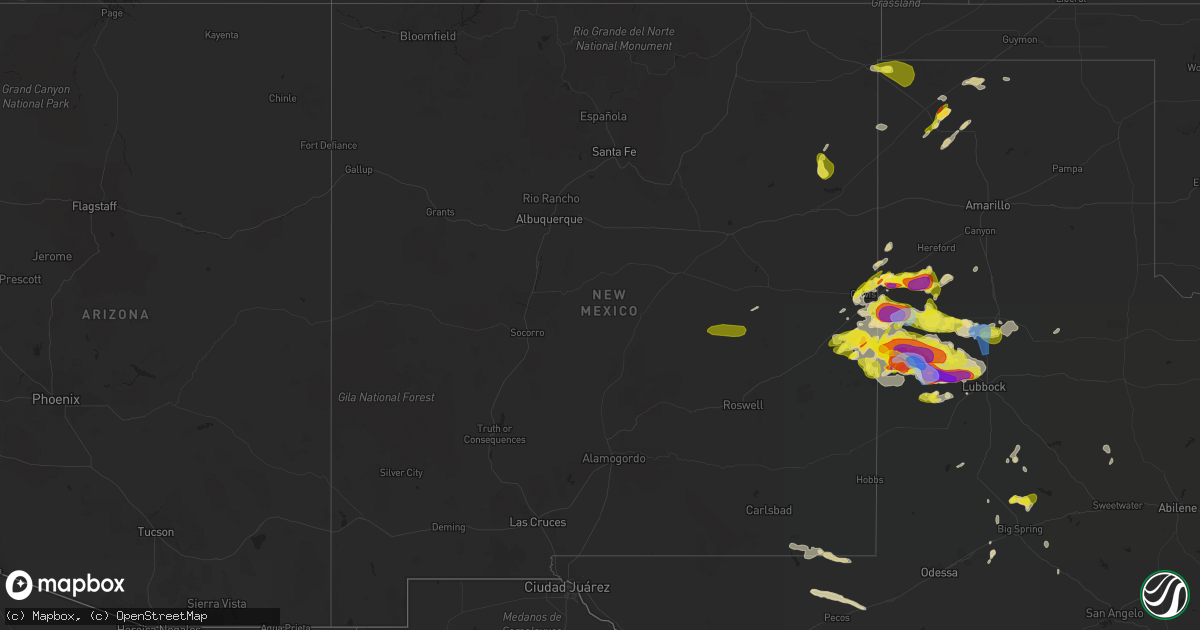
Hail Map in New Mexico on May 23, 2022
Get this storm
May 23 map
$229
one time, instant access
Download today. No call, no setup
Keep the $229
Bought the map and want the full workflow? Apply the entire $229 to a subscription within 7 days. None of it is wasted.
Every map, not just this one
This buys you this map. Subscription and you get every map we run, in the markets you choose from a few cities to whole states to nationwide. Plus real-time alerts the moment a storm fires.
Contact data
Name, contact info, occupancy, even credit band for addresses in the footprint. You go from where it hit to who to call.
Become the source they trust
Unlimited branding weather history reports on demand. You already have the documented answer ready for the property owner, and you are the one who showed up with it.
Property data and RoofTrace estimates
Pull up any address you have got, its value and the exact code rules for that jurisdiction, straight from One Click Code. Then RoofTrace estimates the squares, pitch, and roof value, priced the way you price.
Storm reports in New Mexico
New Mexico
| Date | Description |
|---|---|
| 05/23/20226:18 PM CDT | Video of estimated quarter size hail in clayton via twitter. |
| 05/23/20225:54 PM CDT | From brandon at fire and rescue. |
| 05/23/20225:41 PM CDT | Report from mping: golf ball |
| 05/23/20225:39 PM CDT | Report from mping: quarter |
| 05/23/20225:25 PM CDT | Hail covered the ground. |
| 05/23/20225:10 PM CDT | Covering ground... Marbles up to quarter in size. |
| 05/23/20225:42 AM CDT | At 1042 PM CDT, a severe thunderstorm was located 7 miles north of Sudan, or 9 miles southwest of Earth, moving east at 25 mph. HAZARD...60 mph wind gusts and quarter size hail. SOURCE...Radar indicated. IMPACT...Hail damage to vehicles is expected. Expect wind damage to roofs, siding, and trees. Locations impacted include... Muleshoe, Earth, Sudan, Amherst, Needmore, Progress, Lariat, Muleshoe Wildlife Refuge, West Camp and Springlake. |
| 05/23/20224:01 AM CDT | At 901 PM MDT, a severe thunderstorm was located 18 miles northwest of Ute Lake State Park, or 21 miles southeast of Mosquero, moving southeast at 5 mph. HAZARD...60 mph wind gusts and quarter size hail. SOURCE...Radar indicated. IMPACT...Hail damage to vehicles is expected. Expect wind damage to roofs, siding, and trees. This severe thunderstorm will remain over mainly rural areas of southeastern Harding County. |
| 05/23/20223:00 AM CDT | At 759 PM MDT, a severe thunderstorm was located near Clovis, moving east at 20 mph. HAZARD...60 mph wind gusts and quarter size hail. SOURCE...Radar indicated. IMPACT...Hail damage to vehicles is expected. Expect wind damage to roofs, siding, and trees. Locations impacted include... Clovis, Farwell, Texico, Cannon Air Force Base, Arch, Portair and Pleasant Hill.This includes Highway 60 between Mile Markers 382 and 397. |
| 05/23/202212:49 AM CDT | At 548 PM MDT, a severe thunderstorm was located near Mesa, or 39 miles southwest of Fort Sumner, moving northeast at 20 mph. HAZARD...60 mph wind gusts and quarter size hail. SOURCE...Radar indicated. IMPACT...Hail damage to vehicles is expected. Expect wind damage to roofs, siding, and trees. This severe thunderstorm will remain over mainly rural areas of southwestern De Baca County.This includes Highway 285 between Mile Markers 155 and 166. |
| 05/23/202212:46 AM CDT | At 545 PM CDT, a severe thunderstorm was located 6 miles east of Causey, or 16 miles northwest of Morton, moving northeast at 30 mph. HAZARD...60 mph wind gusts and quarter size hail. SOURCE...Radar indicated. IMPACT...Hail damage to vehicles is expected. Expect wind damage to roofs, siding, and trees. Locations impacted include... Muleshoe, Morton, Needmore, Enochs, Maple and Muleshoe Wildlife Refuge. |
All States Impacted by Hail Map on May 23, 2022
Cities Impacted by Hail Map on May 23, 2022
- Gillett, TX
- Karnes City, TX
- Runge, TX
- Tulia, TX
- Farwell, TX
- Hephzibah, GA
- Augusta, GA
- Clayton, NC
- Wendell, NC
- Gatesville, TX
- Jonesboro, TX
- Channing, TX
- Texline, TX
- Dalhart, TX
- Fort Sumner, NM
- Blythe, GA
- Keysville, GA
- Purmela, TX
- Mebane, NC
- Efland, NC
- Hillsborough, NC
- Welch, TX
- Levelland, TX
- Ropesville, TX
- Plainview, TX
- Dumas, TX
- Louisville, GA
- Wrens, GA
- Rio Grande City, TX
- Garciasville, TX
- Mosquero, NM
- Newington, GA
- Cache, OK
- Statesboro, GA
- Sylvania, GA
- Jasper, FL
- Live Oak, FL
- White Springs, FL
- Claxton, GA
- Glennville, GA
- Laredo, TX
- Pecos, TX
- Pyote, TX
- Littlefield, TX
- Wolfforth, TX
- Balmorhea, TX
- Gail, TX
- Big Spring, TX
- Evant, TX
- Lometa, TX
- Lampasas, TX
- Falls City, TX
- Bainbridge, GA
- Brinson, GA
- San Ygnacio, TX
- Zapata, TX
- Hartley, TX
- Rotan, TX
- Zebulon, NC
- Sardis, GA
- Millen, GA
- Garfield, GA
- Girard, GA
- Rocky Ford, GA
- Stratford, TX
- Swainsboro, GA
- Lyons, GA
- Valdosta, GA
- Moody Afb, GA
- Hahira, GA
- Lakeland, GA
- Ray City, GA
- Bear Creek, NC
- Sanford, NC
- Goldston, NC
- Holly Springs, NC
- Cary, NC
- Apex, NC
- New Hill, NC
- Friona, TX
- Texico, NM
- Fairfax, SC
- Hale Center, TX
- Gruver, TX
- East Dublin, GA
- San Saba, TX
- Cherokee, TX
- Bamberg, SC
- Olar, SC
- Ulmer, SC
- Floydada, TX
- Lockney, TX
- Maysville, NC
- Williston, SC
- Barnwell, SC
- Lenorah, TX
- Ehrhardt, SC
- Jacksonville, NC
- Richlands, NC
- Rio Hondo, TX
- Encinal, TX
- Asherton, TX
- Carrizo Springs, TX
- Cotulla, TX
- Raymondville, TX
- Hargill, TX
- Edcouch, TX
- Lyford, TX
- Lawton, OK
- Garden City, TX
- Wedgefield, SC
- Eastover, SC
- Swansea, SC
- North, SC
- Saint Matthews, SC
- Hopkins, SC
- Gadsden, SC
- Dexter, GA
- Cochran, GA
- Dudley, GA
- Chester, GA
- Buffalo, SD
- Camilla, GA
- Barstow, TX
- Homerville, GA
- Dimmitt, TX
- Dublin, GA
- Portales, NM
- Sundown, TX
- Marlow, OK
- Blackville, SC
- Sterling City, TX
- Midland, TX
- Hamilton, TX
- Jayton, TX
- North Fort Myers, FL
- Grulla, TX
- Edinburg, TX
- Mission, TX
- Santa Elena, TX
- San Isidro, TX
- Linn, TX
- Roma, TX
- Guerra, TX
- Hebbronville, TX
- Delmita, TX
- Hobart, OK
- Abbeville, GA
- Stanton, TX
- Nazareth, TX
- Lake City, FL
- Rogers, NM
- Pep, NM
- Clovis, NM
- Cannon Afb, NM
- Nashville, GA
- Valley Mills, TX
- Amherst, TX
- Morton, TX
- Sudan, TX
- Pep, TX
- Elida, NM
- Enochs, TX
- Maple, TX
- Shallowater, TX
- Anton, TX
- Lubbock, TX
- Muleshoe, TX
- Causey, NM
- Star, TX
- Goldthwaite, TX
- Springlake, TX
- Earth, TX
- Fieldton, TX
- Olton, TX
- Bovina, TX
- Penitas, TX
- La Joya, TX
- Mcallen, TX
- Metter, GA
- Liberty Hill, TX
- Millwood, GA
- Axson, GA
- Petersburg, TX
- Hereford, TX
- Abernathy, TX
- Eastman, GA
- Jal, NM
- Cobbtown, GA
- Collins, GA
- Cairo, GA
- Thomasville, GA
- Mentone, TX
- Loving, NM
- Kinston, NC
- Deep Run, NC
- Coahoma, TX
- Yeso, NM
- Roswell, NM
- Milnesand, NM
- Monetta, SC
- Ridge Spring, SC
- Batesburg, SC
- Edgefield, SC
- Saluda, SC
- Lexington, SC
- Clarks Hill, SC
- Gilbert, SC
- Ward, SC
- Grovetown, GA
- Leesville, SC
- Trenton, SC
- Johnston, SC
- North Augusta, SC
- Evans, GA
- Warrenville, SC
- Jackson, SC
- Beech Island, SC
- Brooklet, GA
- Clyo, GA
- Register, GA
- Guyton, GA
- Springfield, GA
- Pembroke, GA
- Ellabell, GA
- Fort Stewart, GA
- Chesnee, SC
- Boiling Springs, SC
- Concord, NC
- Harrisburg, NC
- Charlotte, NC
- Durham, NC


