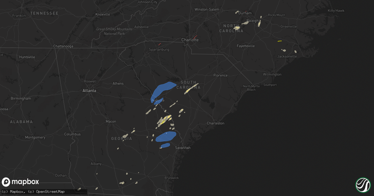
Hail Map in South Carolina on May 23, 2022
Get this storm
May 23 map
$229
one time, instant access
Download today. No call, no setup
Keep the $229
Bought the map and want the full workflow? Apply the entire $229 to a subscription within 7 days. None of it is wasted.
Every map, not just this one
This buys you this map. Subscription and you get every map we run, in the markets you choose from a few cities to whole states to nationwide. Plus real-time alerts the moment a storm fires.
Contact data
Name, contact info, occupancy, even credit band for addresses in the footprint. You go from where it hit to who to call.
Become the source they trust
Unlimited branding weather history reports on demand. You already have the documented answer ready for the property owner, and you are the one who showed up with it.
Property data and RoofTrace estimates
Pull up any address you have got, its value and the exact code rules for that jurisdiction, straight from One Click Code. Then RoofTrace estimates the squares, pitch, and roof value, priced the way you price.
Storm reports in South Carolina
South Carolina
| Date | Description |
|---|---|
| 05/23/20226:54 PM CDT | Tree down near the intersection of harristown road and mendel rivers road. Time estimated based on radar. |
| 05/23/20226:15 PM CDT | Broadcast media reported several large trees down including one on a house. Half dozen buildings destroyed... One house with roof blown off. |
| 05/23/20226:15 PM CDT | Corrects previous tornado report from 1 sw chesnee. Radar indicated tds and confirmation from spartanburg county communications of funnel cloud. |
| 05/23/20226:14 PM CDT | Corrects previous tstm wnd dmg report from 3 w mayo. Broadcast media reported large tree down on power lines on the intersection of sandy ford and paris bridge road. |
| 05/23/20225:55 PM CDT | Dorcheser county 911 dispatch reported a tree was blown down across quaker road in saint george. A motorist had a collision with the tree as it fell. The driver was not |
| 05/23/20225:45 PM CDT | 911 call center reported trees down on catawba river rd |
| 05/23/20225:45 PM CDT | 911 call center reported trees and powerlines down. |
| 05/23/20225:45 PM CDT | Highway patrol reported a tree in the roadway near the intersection of hwy. 78... North road... And kennerly road. |
| 05/23/20225:41 PM CDT | Tree down near the intersection of benton farm road and hudson mill road. Time estimated based on radar. |
| 05/23/20225:40 PM CDT | 911 call center reported several trees down on dewitt and golf course road. |
| 05/23/20225:35 PM CDT | Trees down along i-95 near exit 42. |
| 05/23/20225:33 PM CDT | Tree down near the intersection of sc-63 and us-21. Time estimated based on radar. |
| 05/23/20225:33 PM CDT | Tree down near the intersecton of red root road and deliverance road. Time estimated based on radar. |
| 05/23/20225:33 PM CDT | Trees down near the intersection of lowcountry highway and school house road. Time estimated based on radar. |
| 05/23/20225:21 PM CDT | Tree down near the intersection of grays highway and gillison branch road. Time estimated based on radar. |
| 05/23/20225:15 PM CDT | Radar indicated tds and confirmation from spartanburg county communications of funnel cloud. |
| 05/23/20225:15 PM CDT | Trees blocking two lanes of browninggate road between chocolate city road and two sisters road. Time estimated based on radar. |
| 05/23/20225:14 PM CDT | Broadcast media reported large tree down on power lines on the intersection of sandy ford and paris bridge road. |
| 05/23/20225:12 PM CDT | Tree down near the intersection of sc-3 and johnie peeples dr. Time estimated based on radar. |
| 05/23/20225:10 PM CDT | Sc dot reported several trees down in the area of clear pond rd... Orange grove rd... And ehrhardt rd. Time estimated. |
| 05/23/20225:05 PM CDT | Tree down near the intersetion of tye branch road and richard pollins road. Time estimated based on radar. |
| 05/23/20225:03 PM CDT | Tree down near the intersection of honey hill road and steep bottom road. Time estimated based on radar. |
| 05/23/20224:55 PM CDT | Tree down near the intersection of shirley road and augusta stagecoach road. Time estimated based on radar. |
| 05/23/20224:47 PM CDT | Highway patrol reported a tree down in the roadway and blocked at hwy. 176 and new hope road near pomaria. |
| 05/23/20224:44 PM CDT | Sheriff dispatch reported a large tree down along state park road near aiken state park. |
| 05/23/20221:49 PM CDT | Sheriff dispatch reported trees down on a powerline along hummingbird road near great circle drive. |
| 05/23/20221:45 PM CDT | Public reported hail that began as pea size and increased in size up to nickel to quarter size before ending. The location was along big beaver creek road betweeen i-26 |
| 05/23/202211:00 AM CDT | 3 trees down on first street. |
| 05/23/202210:58 AM CDT | Highway patrol reported a tree down near the intersection of hwy. 176 and parr road. |
| 05/23/202210:52 AM CDT | 1 tree reported down as the storm came through. |
| 05/23/202210:48 AM CDT | Highway patrol reported a tree down near the intersection of macedonia church road and stockman road. |
| 05/23/202210:26 AM CDT | Sheriff dispatch reported a tree fell on a vehicle near the intersection of shiloh heights road and pipeline road. No injuries reported. |
| 05/23/202210:01 AM CDT | Sheriff dispatch reported a tree down at the intersection of woodward lake road and mount zion road. |
| 05/23/20226:30 AM CDT | At 1130 AM EDT, a severe thunderstorm was located near Ridge Spring, or near Batesburg-Leesville, moving northeast at 40 mph. HAZARD...60 mph wind gusts and penny size hail. SOURCE...Radar indicated. IMPACT...Expect damage to trees and powerlines. Locations impacted include... Lexington, Irmo, Batesburg-Leesville, Highway 6 at Lake Murray Dam, Ridge Spring, Saluda County Airport, Dreher Island State Park, Chapin, Gilbert, Summit, Little Mountain, Monetta, Pomaria, Ward, Cedar Grove Fire Station, South Shore Marina, Oswald Park, Saluda Co Sheriff's Office, Bundrick Island and Putnam's Landing.This includes Interstate 26 between mile markers 83 and 92. |
| 05/23/20226:16 AM CDT | At 1116 AM EDT, a severe thunderstorm was located 12 miles northeast of Laurens, or 8 miles north of Clinton, moving northeast at 45 mph. HAZARD...60 mph wind gusts. SOURCE...Radar indicated. IMPACT...Expect damage to trees and power lines. Locations impacted include... Gaffney, Union, Pacolet, Blacksburg, Buffalo, Jonesville, Pacolet Mills, Hickory Grove, Smyrna and Croft State Park. |
| 05/23/20226:03 AM CDT | At 1102 AM EDT, a severe thunderstorm was located near Edgefield County Airport, or 9 miles northeast of Belvedere, moving northeast at 35 mph. HAZARD...60 mph wind gusts and penny size hail. SOURCE...Radar indicated. IMPACT...Expect damage to trees and powerlines. Locations impacted include... Aiken, Batesburg-Leesville, Aiken Mall, Edgefield, Saluda, Johnston, Ridge Spring, USC Aiken, Saluda County Airport, Edgefield County Airport, Citizens Park, Aiken Municipal Airport, Graniteville, Gloverville, Wagener, Monetta, Trenton, Ward, Strom Thurmond High School and Saluda Co Sheriff's Office.This includes Interstate 20 in South Carolina between mile markers 11and 36. |
| 05/23/20225:40 AM CDT | At 1039 AM EDT, a severe thunderstorm was located over Fort Gordon, moving northeast at 35 mph. HAZARD...60 mph wind gusts and penny size hail. SOURCE...Radar indicated. IMPACT...Expect damage to trees and powerlines. Locations impacted include... Aiken, North Augusta, Grovetown, Evans, Martinez, Fort Gordon, Augusta, Clearwater, Belvedere, Edgefield, Hephzibah, Glendale, South Augusta, Midtown, Riverwood, Summerville, Augusta Mall, Daniel Field, Village Plaza Shopping Center and Augusta National Golf Club.This includes the following highways... Interstate 20 in Georgia between mile markers 184 and 201. Interstate 20 in South Carolina between mile markers 0 and 13. Interstate 520 in Georgia between mile markers 1 and 15. Interstate 520 in South Carolina between mile markers 16 and 23. |
| 05/23/20222:06 AM CDT | At 705 PM EDT, severe thunderstorms were located along a line extending from near Holly Hill to 7 miles southwest of Dorchester to White Hall, moving east at 40 mph. HAZARD...60 mph wind gusts. SOURCE...Radar indicated. IMPACT...Expect damage to trees and powerlines. These thunderstorms have a history of scattered tree damage. Locations impacted include: North Charleston, Summerville, Goose Creek, Moncks Corner, Givhans Ferry State Park, Ladson, Dorchester, Ridgeville, Saint Stephen, Cottageville, Harleyville, Bonneau, Jamestown, Givhans and Cross.This warning includes the following interstates: I-26 between mile markers 171 and 204. I-95 in South Carolina near mile marker 85. |
| 05/23/20221:26 AM CDT | At 626 PM EDT, severe thunderstorms were located along a line extending from Lodge to Gillisonville, moving northeast at 40 mph. HAZARD...60 mph wind gusts. SOURCE...Radar indicated. IMPACT...Expect damage to trees and powerlines. Locations impacted include: Walterboro, Saint George, Yemassee, Colleton, Varnville, Cottageville, Reevesville, Smoaks, Lodge, Williams, Ruffin, Miley, Grays, Ashton and Hendersonville.This warning includes I-95 in South Carolina between mile markers 35and 82. |
| 05/23/20221:06 AM CDT | At 605 PM EDT, severe thunderstorms were located along a line extending from near Ellabell to McIntosh to near Tibet, moving northeast at 40 mph. HAZARD...60 mph wind gusts and penny size hail. SOURCE...Radar indicated. IMPACT...Expect damage to trees and powerlines. Locations impacted include: Hinesville, Pooler, Bluffton, Richmond Hill, Tybee Island, Darien, Tibet, Bellinger Hill Area, Savannah International Airport, Fort Stewart, Wilmington Island, Fort Pulaski National Monument, Midtown Savannah, Downtown Savannah and Coffee Bluff.This warning includes the following interstates: I-16 between mile markers 147 and 168. I-516 between mile markers 3 and 9. I-95 in South Carolina between mile markers 2 and 10. I-95 in Georgia between mile markers 50 and 112. |
| 05/23/202212:53 AM CDT | At 552 PM EDT, a severe thunderstorm was located 7 miles south of Denmark, moving northeast at 20 mph. HAZARD...60 mph wind gusts and nickel size hail. SOURCE...Radar indicated. IMPACT...Expect damage to trees and powerlines. Locations impacted include... Bamberg, Denmark, Olar, Govan and Bamberg County Airport. |
| 05/22/202211:47 PM CDT | At 447 PM EDT, severe thunderstorms were located along a line extending from near Perkins to near Surrency, moving east at 15 mph. HAZARD...60 mph wind gusts and penny size hail. SOURCE...Radar indicated. IMPACT...Expect damage to trees and powerlines. Locations impacted include: Hinesville, Statesboro, Reidsville, Metter, Glennville, Millen, Sylvania, Claxton, Pembroke, Ludowici, Fort Stewart, Butts, Brooklet, Hagan and Portal.This warning includes I-16 between mile markers 96 and 135. |
| 05/22/20229:43 PM CDT | At 242 PM EDT, a severe thunderstorm was located near Sandy Run, or 11 miles southwest of McEntire Air Base, moving northeast at 40 mph. HAZARD...60 mph wind gusts and half dollar size hail. SOURCE...Radar indicated. IMPACT...Hail damage to vehicles is expected. Expect wind damage to trees and powerlines. Locations impacted include... Columbia, McEntire Air Base, Eastover, Congaree National Park, Hopkins, Sandy Run, Gadsden, Poinsett State Park, Horrel Hill, Fort Motte, Wedgewood, Fort Jackson McCrady Training Center and Stateburg.This includes Interstate 26 between mile markers 124 and 137. |
| 05/22/20229:32 PM CDT | At 231 PM EDT, severe thunderstorms were located along a line extending from 13 miles south of Biscoe to near Hamlet to near Cheraw State Park, moving northeast at 35 mph. HAZARD...60 mph wind gusts. SOURCE...Radar indicated. IMPACT...Expect damage to roofs, siding, and trees. Locations impacted include... Laurinburg, Southern Pines, Rockingham, Raeford, Carthage, Pinehurst, Hamlet, Aberdeen, Maxton and Hoffman. |
| 05/22/20228:44 PM CDT | At 144 PM EDT, severe thunderstorms were located along a line extending from near Midland to near Sturdivants, moving northeast at 40 mph. HAZARD...60 mph wind gusts. SOURCE...Radar indicated. IMPACT...Expect damage to roofs, siding, and trees. Locations impacted include... Albemarle, Rockingham, Wadesboro, Troy, Badin Lake, Hamlet, Ansonville, Plyler, Polkton and Locust. |
| 05/22/20227:20 PM CDT | Two mature loblolly pine trees snapped in moore farms botanical garden. Time estimated via radar. |
All States Impacted by Hail Map on May 23, 2022
Cities Impacted by Hail Map on May 23, 2022
- Gillett, TX
- Karnes City, TX
- Runge, TX
- Tulia, TX
- Farwell, TX
- Hephzibah, GA
- Augusta, GA
- Clayton, NC
- Wendell, NC
- Gatesville, TX
- Jonesboro, TX
- Channing, TX
- Texline, TX
- Dalhart, TX
- Fort Sumner, NM
- Blythe, GA
- Keysville, GA
- Purmela, TX
- Mebane, NC
- Efland, NC
- Hillsborough, NC
- Welch, TX
- Levelland, TX
- Ropesville, TX
- Plainview, TX
- Dumas, TX
- Louisville, GA
- Wrens, GA
- Rio Grande City, TX
- Garciasville, TX
- Mosquero, NM
- Newington, GA
- Cache, OK
- Statesboro, GA
- Sylvania, GA
- Jasper, FL
- Live Oak, FL
- White Springs, FL
- Claxton, GA
- Glennville, GA
- Laredo, TX
- Pecos, TX
- Pyote, TX
- Littlefield, TX
- Wolfforth, TX
- Balmorhea, TX
- Gail, TX
- Big Spring, TX
- Evant, TX
- Lometa, TX
- Lampasas, TX
- Falls City, TX
- Bainbridge, GA
- Brinson, GA
- San Ygnacio, TX
- Zapata, TX
- Hartley, TX
- Rotan, TX
- Zebulon, NC
- Sardis, GA
- Millen, GA
- Garfield, GA
- Girard, GA
- Rocky Ford, GA
- Stratford, TX
- Swainsboro, GA
- Lyons, GA
- Valdosta, GA
- Moody Afb, GA
- Hahira, GA
- Lakeland, GA
- Ray City, GA
- Bear Creek, NC
- Sanford, NC
- Goldston, NC
- Holly Springs, NC
- Cary, NC
- Apex, NC
- New Hill, NC
- Friona, TX
- Texico, NM
- Fairfax, SC
- Hale Center, TX
- Gruver, TX
- East Dublin, GA
- San Saba, TX
- Cherokee, TX
- Bamberg, SC
- Olar, SC
- Ulmer, SC
- Floydada, TX
- Lockney, TX
- Maysville, NC
- Williston, SC
- Barnwell, SC
- Lenorah, TX
- Ehrhardt, SC
- Jacksonville, NC
- Richlands, NC
- Rio Hondo, TX
- Encinal, TX
- Asherton, TX
- Carrizo Springs, TX
- Cotulla, TX
- Raymondville, TX
- Hargill, TX
- Edcouch, TX
- Lyford, TX
- Lawton, OK
- Garden City, TX
- Wedgefield, SC
- Eastover, SC
- Swansea, SC
- North, SC
- Saint Matthews, SC
- Hopkins, SC
- Gadsden, SC
- Dexter, GA
- Cochran, GA
- Dudley, GA
- Chester, GA
- Buffalo, SD
- Camilla, GA
- Barstow, TX
- Homerville, GA
- Dimmitt, TX
- Dublin, GA
- Portales, NM
- Sundown, TX
- Marlow, OK
- Blackville, SC
- Sterling City, TX
- Midland, TX
- Hamilton, TX
- Jayton, TX
- North Fort Myers, FL
- Grulla, TX
- Edinburg, TX
- Mission, TX
- Santa Elena, TX
- San Isidro, TX
- Linn, TX
- Roma, TX
- Guerra, TX
- Hebbronville, TX
- Delmita, TX
- Hobart, OK
- Abbeville, GA
- Stanton, TX
- Nazareth, TX
- Lake City, FL
- Rogers, NM
- Pep, NM
- Clovis, NM
- Cannon Afb, NM
- Nashville, GA
- Valley Mills, TX
- Amherst, TX
- Morton, TX
- Sudan, TX
- Pep, TX
- Elida, NM
- Enochs, TX
- Maple, TX
- Shallowater, TX
- Anton, TX
- Lubbock, TX
- Muleshoe, TX
- Causey, NM
- Star, TX
- Goldthwaite, TX
- Springlake, TX
- Earth, TX
- Fieldton, TX
- Olton, TX
- Bovina, TX
- Penitas, TX
- La Joya, TX
- Mcallen, TX
- Metter, GA
- Liberty Hill, TX
- Millwood, GA
- Axson, GA
- Petersburg, TX
- Hereford, TX
- Abernathy, TX
- Eastman, GA
- Jal, NM
- Cobbtown, GA
- Collins, GA
- Cairo, GA
- Thomasville, GA
- Mentone, TX
- Loving, NM
- Kinston, NC
- Deep Run, NC
- Coahoma, TX
- Yeso, NM
- Roswell, NM
- Milnesand, NM
- Monetta, SC
- Ridge Spring, SC
- Batesburg, SC
- Edgefield, SC
- Saluda, SC
- Lexington, SC
- Clarks Hill, SC
- Gilbert, SC
- Ward, SC
- Grovetown, GA
- Leesville, SC
- Trenton, SC
- Johnston, SC
- North Augusta, SC
- Evans, GA
- Warrenville, SC
- Jackson, SC
- Beech Island, SC
- Brooklet, GA
- Clyo, GA
- Register, GA
- Guyton, GA
- Springfield, GA
- Pembroke, GA
- Ellabell, GA
- Fort Stewart, GA
- Chesnee, SC
- Boiling Springs, SC
- Concord, NC
- Harrisburg, NC
- Charlotte, NC
- Durham, NC


