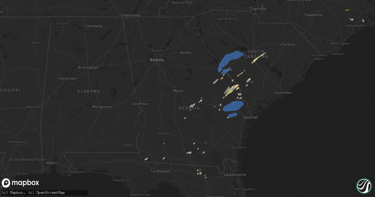
Hail Map in Georgia on May 23, 2022
Get this storm
May 23 map
$229
one time, instant access
Download today. No call, no setup
Keep the $229
Bought the map and want the full workflow? Apply the entire $229 to a subscription within 7 days. None of it is wasted.
Every map, not just this one
This buys you this map. Subscription and you get every map we run, in the markets you choose from a few cities to whole states to nationwide. Plus real-time alerts the moment a storm fires.
Contact data
Name, contact info, occupancy, even credit band for addresses in the footprint. You go from where it hit to who to call.
Become the source they trust
Unlimited branding weather history reports on demand. You already have the documented answer ready for the property owner, and you are the one who showed up with it.
Property data and RoofTrace estimates
Pull up any address you have got, its value and the exact code rules for that jurisdiction, straight from One Click Code. Then RoofTrace estimates the squares, pitch, and roof value, priced the way you price.
Storm reports in Georgia
Georgia
| Date | Description |
|---|---|
| 05/23/20224:35 PM CDT | Tree down near the intersection of highway 19 and george edwards road. Time estimated based on radar. |
| 05/23/20224:32 PM CDT | Tree down on a house along warnell street in pembroke. Time estimated based on radar. |
| 05/23/20224:14 PM CDT | Tree down near the intersection of old register way and bohler rimes road. |
| 05/23/20224:02 PM CDT | Two trees down near the intersection of stoney hill road and romie waters highway. Time estimated by radar. |
| 05/23/20223:56 PM CDT | Tree down near the intersection of metter road and brack road. Time estimated by radar. |
| 05/23/20223:22 PM CDT | Tree down near the intersection of rosemary church road and lawrence road. Time estimated by radar. |
| 05/23/20223:19 PM CDT | Candler county sheriff's office relayed images of numerous trees with some power poles down along rosemary church road. Damage is consistent with straight line winds. T |
| 05/23/20223:19 PM CDT | Tree down near the intersection of portal highway and rosemary church road. Time estimated by radar. |
| 05/23/20223:18 PM CDT | Tree down across shiloh rd 3 miles east of hwy 441. |
| 05/23/20223:14 PM CDT | Tree down over shiloh rd near the intersection with hwy 441. |
| 05/23/20223:13 PM CDT | A few trees down near the intersection fo harrison-davisboro rd and brown circle |
| 05/23/20223:13 PM CDT | A few trees down near the intersection fo harrison-davisboro rd and brown circle |
| 05/23/20223:11 PM CDT | Tree down near the intersection of ga-46 and fifteen mile creek road. Tree down near the intersection of ga-46 and lake church road. Time estimated by radar. |
| 05/23/20223:11 PM CDT | Tree down near the intersection of ga-46 and fifteen mile creek road. Time estimated by radar. |
| 05/23/20222:52 PM CDT | 30 to 40 pecan trees downed or with snapped limbs on us hwy 280 and mcgregor-alston road |
| 05/23/20222:20 PM CDT | Numerous reports of trees down along carver russ road and ice plant road. Along with tree and wind damage to a shed on paulk street. Time is estimated based on radar im |
| 05/23/202210:05 AM CDT | Sheriff dispatch reported a tree down at the intersection of pepperidge drive and peach orchard road. |
| 05/23/20229:49 AM CDT | Corrects previous tstm wnd dmg report from appling. Sheriff dispatch reported a power line down just south of the intersection of ray owens road and white oak road. |
| 05/23/20227:49 AM CDT | At 1249 PM EDT, a severe thunderstorm was located near Cairo, moving northeast at 20 mph. HAZARD...60 mph wind gusts and penny size hail. SOURCE...Radar indicated. IMPACT...Expect damage to roofs, siding, and trees. Locations impacted include... Thomasville, Ochlocknee, Dawesville, Dillon, Pine Park, Pasco and Merrillville. |
| 05/23/202212:29 AM CDT | At 529 PM EDT, severe thunderstorms were located along a line extending from Hunters to near Pembroke, moving northeast at 45 mph. HAZARD...60 mph wind gusts and penny size hail. SOURCE...Radar indicated. IMPACT...Expect damage to trees and powerlines. Locations impacted include: Ridgeland, Springfield, Hampton, Pembroke, Lake Warren State Park, Godley Station, Lanier, Rincon, Port Wentworth, Hardeeville, Varnville, Estill, Guyton, Brooklet and Brunson.This warning includes the following interstates: I-16 between mile markers 126 and 150. I-95 in South Carolina between mile markers 8 and 18. |
| 05/23/202212:06 AM CDT | At 506 AM EDT, a severe thunderstorm was located over North Fort Benning, or 12 miles north of Cusseta, moving north at 40 mph. HAZARD...60 mph wind gusts and quarter size hail. SOURCE...Radar indicated. IMPACT...Hail damage to vehicles is expected. Expect wind damage to roofs, siding, and trees. Locations impacted include... Manchester, Waverly Hall, Woodland, North Fort Benning, Upatoi, Ellerslie, Flat Rock, F.d. Roosevelt State Park, Vista Terrace, Baughville, Flint Hill, Olive Branch, Box Springs, Midland, Eelbeck/West Fort Benning and Sand Hill. |
| 05/23/202212:06 AM CDT | At 505 PM EDT, a severe thunderstorm was located over Burtons Ferry Landing, moving northeast at 20 mph. Additional severe thunderstorms will advance into the region from the west before 6 pm EDT. HAZARD...60 mph wind gusts and quarter size hail. SOURCE...Radar indicated. IMPACT...Minor hail damage to vehicles is possible. Expect wind damage to trees and powerlines. Locations impacted include: Allendale, Fairfax, Sycamore, Ulmer, Seigling, Martin, Barton and Appleton. |
| 05/22/202211:07 PM CDT | At 406 PM EDT, a severe thunderstorm was located over Riddleville, or 10 miles southeast of Sandersville, moving northeast at 45 mph. HAZARD...60 mph wind gusts. SOURCE...Radar indicated. IMPACT...Expect damage to roofs, siding, and trees. Locations impacted include... Louisville, Wadley, Davisboro, Bartow, Riddleville, Moxley and Stapletons Crossroads. |
| 05/22/202210:33 PM CDT | At 333 PM EDT, a severe thunderstorm was located near Burtons Ferry Landing, moving northeast at 15 mph. HAZARD...60 mph wind gusts and quarter size hail. SOURCE...Radar indicated. IMPACT...Minor hail damage to vehicles is possible. Expect wind damage to trees and powerlines. Locations impacted include: Hiltonia, Millett, Martin, Millhaven, Appleton and Hilltonia. |
| 05/22/202210:33 PM CDT | At 333 PM EDT, a severe thunderstorm was located near West Bainbridge, or near Bainbridge, moving northeast at 25 mph. HAZARD...60 mph wind gusts. SOURCE...Radar indicated. IMPACT...Expect damage to roofs, siding, and trees. Locations impacted include... Bainbridge, West Bainbridge, Climax, Hanover, Ausmac, Fowlstown, Decatur Co A/P and Steinham Store. |
| 05/22/202210:09 PM CDT | At 308 PM EDT, a severe thunderstorm was located over Willacoochee, moving north at 20 mph. HAZARD...60 mph wind gusts and quarter size hail. SOURCE...Radar indicated. IMPACT...Hail damage to vehicles is expected. Expect wind damage to roofs, siding, and trees. Locations impacted include... Douglas and Willacoochee. |
| 05/22/202210:02 PM CDT | At 302 PM EDT/202 PM CDT/, severe thunderstorms were located along a line extending from near Chipley to 9 miles southwest of Marianna to 8 miles west of Blountstown, moving east at 45 mph. HAZARD...60 mph wind gusts. SOURCE...Radar indicated. IMPACT...Expect damage to roofs, siding, and trees. Locations impacted include... Blountstown, Marianna, Chipley, Chattahoochee, Bradford, Sneads, Bristol, Cottondale, Grand Ridge, Greenwood, Altha, Alford, Rock Bluff, Moose Pond, Clarksville, Ocheesee, Selman, Abe Springs, Chipola and Camps Head. |
| 05/22/20229:20 PM CDT | At 220 PM EDT, a severe thunderstorm was located near Scarboro, moving northeast at 25 mph. HAZARD...60 mph wind gusts and quarter size hail. SOURCE...Radar indicated. IMPACT...Minor hail damage to vehicles is possible. Expect wind damage to trees and powerlines. Locations impacted include: Millen, Hiltonia, Woodcliff, Hilltonia, Emmalane, Millhaven, Scarboro and Burtons Ferry Landing. |
All States Impacted by Hail Map on May 23, 2022
Cities Impacted by Hail Map on May 23, 2022
- Gillett, TX
- Karnes City, TX
- Runge, TX
- Tulia, TX
- Farwell, TX
- Hephzibah, GA
- Augusta, GA
- Clayton, NC
- Wendell, NC
- Gatesville, TX
- Jonesboro, TX
- Channing, TX
- Texline, TX
- Dalhart, TX
- Fort Sumner, NM
- Blythe, GA
- Keysville, GA
- Purmela, TX
- Mebane, NC
- Efland, NC
- Hillsborough, NC
- Welch, TX
- Levelland, TX
- Ropesville, TX
- Plainview, TX
- Dumas, TX
- Louisville, GA
- Wrens, GA
- Rio Grande City, TX
- Garciasville, TX
- Mosquero, NM
- Newington, GA
- Cache, OK
- Statesboro, GA
- Sylvania, GA
- Jasper, FL
- Live Oak, FL
- White Springs, FL
- Claxton, GA
- Glennville, GA
- Laredo, TX
- Pecos, TX
- Pyote, TX
- Littlefield, TX
- Wolfforth, TX
- Balmorhea, TX
- Gail, TX
- Big Spring, TX
- Evant, TX
- Lometa, TX
- Lampasas, TX
- Falls City, TX
- Bainbridge, GA
- Brinson, GA
- San Ygnacio, TX
- Zapata, TX
- Hartley, TX
- Rotan, TX
- Zebulon, NC
- Sardis, GA
- Millen, GA
- Garfield, GA
- Girard, GA
- Rocky Ford, GA
- Stratford, TX
- Swainsboro, GA
- Lyons, GA
- Valdosta, GA
- Moody Afb, GA
- Hahira, GA
- Lakeland, GA
- Ray City, GA
- Bear Creek, NC
- Sanford, NC
- Goldston, NC
- Holly Springs, NC
- Cary, NC
- Apex, NC
- New Hill, NC
- Friona, TX
- Texico, NM
- Fairfax, SC
- Hale Center, TX
- Gruver, TX
- East Dublin, GA
- San Saba, TX
- Cherokee, TX
- Bamberg, SC
- Olar, SC
- Ulmer, SC
- Floydada, TX
- Lockney, TX
- Maysville, NC
- Williston, SC
- Barnwell, SC
- Lenorah, TX
- Ehrhardt, SC
- Jacksonville, NC
- Richlands, NC
- Rio Hondo, TX
- Encinal, TX
- Asherton, TX
- Carrizo Springs, TX
- Cotulla, TX
- Raymondville, TX
- Hargill, TX
- Edcouch, TX
- Lyford, TX
- Lawton, OK
- Garden City, TX
- Wedgefield, SC
- Eastover, SC
- Swansea, SC
- North, SC
- Saint Matthews, SC
- Hopkins, SC
- Gadsden, SC
- Dexter, GA
- Cochran, GA
- Dudley, GA
- Chester, GA
- Buffalo, SD
- Camilla, GA
- Barstow, TX
- Homerville, GA
- Dimmitt, TX
- Dublin, GA
- Portales, NM
- Sundown, TX
- Marlow, OK
- Blackville, SC
- Sterling City, TX
- Midland, TX
- Hamilton, TX
- Jayton, TX
- North Fort Myers, FL
- Grulla, TX
- Edinburg, TX
- Mission, TX
- Santa Elena, TX
- San Isidro, TX
- Linn, TX
- Roma, TX
- Guerra, TX
- Hebbronville, TX
- Delmita, TX
- Hobart, OK
- Abbeville, GA
- Stanton, TX
- Nazareth, TX
- Lake City, FL
- Rogers, NM
- Pep, NM
- Clovis, NM
- Cannon Afb, NM
- Nashville, GA
- Valley Mills, TX
- Amherst, TX
- Morton, TX
- Sudan, TX
- Pep, TX
- Elida, NM
- Enochs, TX
- Maple, TX
- Shallowater, TX
- Anton, TX
- Lubbock, TX
- Muleshoe, TX
- Causey, NM
- Star, TX
- Goldthwaite, TX
- Springlake, TX
- Earth, TX
- Fieldton, TX
- Olton, TX
- Bovina, TX
- Penitas, TX
- La Joya, TX
- Mcallen, TX
- Metter, GA
- Liberty Hill, TX
- Millwood, GA
- Axson, GA
- Petersburg, TX
- Hereford, TX
- Abernathy, TX
- Eastman, GA
- Jal, NM
- Cobbtown, GA
- Collins, GA
- Cairo, GA
- Thomasville, GA
- Mentone, TX
- Loving, NM
- Kinston, NC
- Deep Run, NC
- Coahoma, TX
- Yeso, NM
- Roswell, NM
- Milnesand, NM
- Monetta, SC
- Ridge Spring, SC
- Batesburg, SC
- Edgefield, SC
- Saluda, SC
- Lexington, SC
- Clarks Hill, SC
- Gilbert, SC
- Ward, SC
- Grovetown, GA
- Leesville, SC
- Trenton, SC
- Johnston, SC
- North Augusta, SC
- Evans, GA
- Warrenville, SC
- Jackson, SC
- Beech Island, SC
- Brooklet, GA
- Clyo, GA
- Register, GA
- Guyton, GA
- Springfield, GA
- Pembroke, GA
- Ellabell, GA
- Fort Stewart, GA
- Chesnee, SC
- Boiling Springs, SC
- Concord, NC
- Harrisburg, NC
- Charlotte, NC
- Durham, NC


