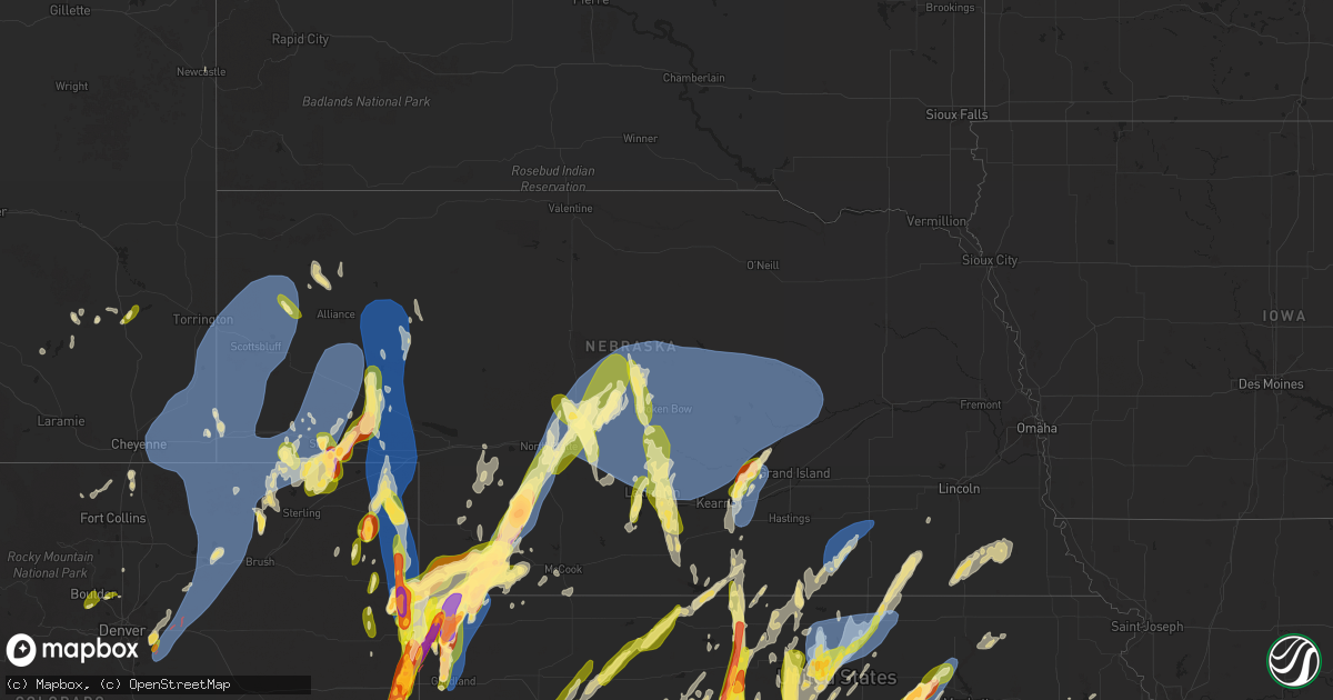
Hail Map in Nebraska on May 18, 2025
Get this storm
May 18 map
$229
one time, instant access
Download today. No call, no setup
Keep the $229
Bought the map and want the full workflow? Apply the entire $229 to a subscription within 7 days. None of it is wasted.
Every map, not just this one
This buys you this map. Subscription and you get every map we run, in the markets you choose from a few cities to whole states to nationwide. Plus real-time alerts the moment a storm fires.
Contact data
Name, contact info, occupancy, even credit band for addresses in the footprint. You go from where it hit to who to call.
Become the source they trust
Unlimited branding weather history reports on demand. You already have the documented answer ready for the property owner, and you are the one who showed up with it.
Property data and RoofTrace estimates
Pull up any address you have got, its value and the exact code rules for that jurisdiction, straight from One Click Code. Then RoofTrace estimates the squares, pitch, and roof value, priced the way you price.
Storm reports in Nebraska
Nebraska
| Date | Description |
|---|---|
| 05/18/20256:59 PM CDT | Weak tornado crossed hwy 34 roughly here; downed power lines and tipped over pivots. |
| 05/18/20256:57 PM CDT | Video of a tornado moving over highway 34. |
| 05/18/20256:54 PM CDT | Off duty nws employee reported tornado just east of max and north of highway 34. |
| 05/18/20256:47 PM CDT | Report of golf ball sized hail just west of max... Ne. |
| 05/18/20256:39 PM CDT | A local report indicates 61 MPH wind near 10 N Chappell |
| 05/18/20256:38 PM CDT | Report from mping: golf ball |
| 05/18/20256:37 PM CDT | Report from mping: ping pong ball |
| 05/18/20256:32 PM CDT | Report from mping: quarter |
| 05/18/20256:28 PM CDT | Trained spotter reports hail up to 2 inches with photos. |
| 05/18/20256:27 PM CDT | Report from mping: quarter |
| 05/18/20256:16 PM CDT | A local report indicates 71 MPH wind near Scottsbluff |
| 05/18/20256:07 PM CDT | A local report indicates 1.00 inch wind near 2 N Sidney |
| 05/18/20256:06 PM CDT | A local report indicates 69 MPH wind near 4 WNW Terrytown |
| 05/18/20256:05 PM CDT | A local report indicates 69 MPH wind near Scottsbluff |
| 05/18/20255:45 PM CDT | Trained spotter reports 2 inch diameter hail. |
| 05/18/20255:35 PM CDT | Trained spotter reports quarter size hail. |
| 05/18/20255:35 PM CDT | A local report indicates 1.00 inch wind near 4 S Sidney |
| 05/18/20255:15 PM CDT | A local report indicates 70 MPH wind near Kimball |
| 05/18/20255:00 PM CDT | A local report indicates 1.00 inch wind near 8 S Potter |
| 05/18/20253:36 AM CDT | Delayed report of tree damage in clarkson... Ne. Time based on radar. |
| 05/18/20253:31 AM CDT | Delayed report of thunderstorm wind damage... Near intersection of rd 8 and rd t. Time based |
| 05/18/20253:31 AM CDT | Delayed report of thunderstorm wind damage... Near intersection of rd 8 |
| 05/18/20253:31 AM CDT | Delayed report of thunderstorm wind damage... Near intersection of rd 8 and rd t. Time based on radar. |
| 05/18/20253:30 AM CDT | Delayed report of porch/roof damage. Time estimated based on radar. |
| 05/18/202512:18 AM CDT | Delayed report of |
| 05/18/202512:18 AM CDT | Delayed report of tree limbs down relayed by local emergency management. Time estimated based on radar. |
| 05/17/202511:37 PM CDT | Emergency manager reports 60mph winds in miller. |
| 05/17/202511:30 PM CDT | A local report indicates 68 MPH wind near 4 SE Eddyville |
| 05/17/202510:48 PM CDT | A local report indicates 67 MPH wind near 5 S Anselmo |
| 05/17/202510:40 PM CDT | Time estimated by radar. |
| 05/17/202510:15 PM CDT | A local report indicates 59 MPH wind near Grand Island Airport |
| 05/17/20259:40 PM CDT | A local report indicates 63 MPH wind near 6 WNW Maxwell |
| 05/17/20259:38 PM CDT | A local report indicates 1.00 inch wind near 4 E North Platte |
| 05/17/20259:33 PM CDT | A local report indicates 59 MPH wind near 4 SE Edgar |
| 05/17/20259:32 PM CDT | A local report indicates 60 MPH wind near 3 NNW Oak |
| 05/17/20258:48 PM CDT | A local report indicates 1.00 inch wind near 2 W North Platte |
| 05/17/20258:46 PM CDT | Report from mping: baseball+ |
| 05/17/20258:20 PM CDT | A local report indicates 65 MPH wind near 6 SW Boelus |
| 05/17/20258:16 PM CDT | Report from mping: quarter |
| 05/17/20258:01 PM CDT | Possible tornado damage reported. |
| 05/17/20258:00 PM CDT | A local report indicates 61 MPH wind near 3 N Hayes Center |
| 05/17/20257:59 PM CDT | Report from mping: golf ball |
| 05/17/20257:59 PM CDT | Report from mping. |
| 05/17/20257:55 PM CDT | Spotter reports quarter sized hail. |
| 05/17/20257:49 PM CDT | A local report indicates 1.00 inch wind near 7 NNW Gibbon |
| 05/17/20257:35 PM CDT | Spotter reports quarter sized hail near darr. |
| 05/17/20257:16 PM CDT | Roof damage to home at in stratton at mm 50. |
| 05/17/20257:12 PM CDT | Report of downed power lines from spotter network. |
| 05/17/20257:07 PM CDT | Spotter reports quarter sized hail west-southwest of overton. |
| 05/17/20257:03 PM CDT | Caller reported two inch hail along with broad rotation. |
| 05/17/20257:00 PM CDT | Sheet metal in ditch... Power poles down.... |
All States Impacted by Hail Map on May 18, 2025
Cities Impacted by Hail Map on May 18, 2025
- Northport, AL
- Coker, AL
- Echola, AL
- Elrod, AL
- Gordo, AL
- Buhl, AL
- Adger, AL
- Brookwood, AL
- Tuscaloosa, AL
- Cottondale, AL
- Dolomite, AL
- Birmingham, AL
- Bessemer, AL
- Pleasant Grove, AL
- Woodstock, AL
- West Blocton, AL
- Helena, AL
- Brierfield, AL
- McCalla, AL
- Vance, AL
- Alpine, AL
- Munford, AL
- Ashland, AL
- Sylacauga, AL
- Delta, AL
- Lincoln, AL
- Oxford, AL
- Eastaboga, AL
- Talladega, AL
- Lineville, AL
- Harpersville, AL
- Childersburg, AL
- Sterrett, AL
- Vincent, AL
- Columbiana, AL
- Wilsonville, AL
- Cropwell, AL
- Cabot, AR
- Lonoke, AR
- Daviston, AL
- Cragford, AL
- Wadley, AL
- Goodwater, AL
- Alexander City, AL
- Carlisle, AR
- Hazen, AR
- Roanoke, AL
- Lafayette, AL
- Stuttgart, AR
- Millerville, AL
- Camp Hill, AL
- De Valls Bluff, AR
- Roe, AR
- Clarendon, AR
- Five Points, AL
- Holly Grove, AR
- Brinkley, AR
- Lanett, AL
- Lyon, MS
- Mellwood, AR
- Clarksdale, MS
- Crumrod, AR
- Elaine, AR
- Pryor, OK
- Adair, OK
- Tuskegee, AL
- Marks, MS
- Alligator, MS
- Hatchechubbee, AL
- Union Springs, AL
- Duncan, MS
- Tutwiler, MS
- Vance, MS
- Charleston, MS
- Lambert, MS
- Seale, AL
- Fort Mitchell, AL
- Cascilla, MS
- Holcomb, MS
- Enid, MS
- Wedowee, AL
- Franklin, GA
- Hogansville, GA
- Lagrange, GA
- Molena, GA
- Greenville, GA
- Concord, GA
- Gay, GA
- Woodbury, GA
- Warm Springs, GA
- Waverly Hall, GA
- Manchester, GA
- West Point, GA
- Thomaston, GA
- Hamilton, GA
- Pine Mountain, GA
- Pine Mountain Valley, GA
- Woodland, GA
- Shiloh, GA
- Talbotton, GA
- Meansville, GA
- Yatesville, GA
- The Rock, GA
- Roberta, GA
- Knoxville, GA
- Culloden, GA
- Lizella, GA
- Butler, GA
- Musella, GA
- Fort Valley, GA
- Junction City, GA
- Reynolds, GA
- Byron, GA
- Scobey, MS
- Grenada, MS
- Coffeeville, MS
- Tillatoba, MS
- Macon, GA
- Bonaire, GA
- Warner Robins, GA
- Centerville, GA
- Kathleen, GA
- Spavinaw, OK
- Salina, OK
- West Point, MS
- Prairie, MS
- Porter, OK
- Wagoner, OK
- Aberdeen, MS
- Chouteau, OK
- Vian, OK
- Locust Grove, OK
- Tahlequah, OK
- Hulbert, OK
- Bunch, OK
- Sallisaw, OK
- Peggs, OK
- Cleveland, OK
- Hominy, OK
- Pawnee, OK
- Stilwell, OK
- Rose, OK
- Colcord, OK
- Muldrow, OK
- Dadeville, AL
- Junction, TX
- Eucha, OK
- Tulsa, OK
- Sapulpa, OK
- Jay, OK
- Lincoln, AR
- Summers, AR
- Uniontown, AR
- Skiatook, OK
- Westville, OK
- Harper, TX
- Sperry, OK
- Collinsville, OK
- Cedarville, AR
- Rudy, AR
- Van Buren, AR
- Chester, AR
- Hoboken, GA
- Nahunta, GA
- Owasso, OK
- Mountainburg, AR
- Catoosa, OK
- Ramona, OK
- Vera, OK
- Barnsdall, OK
- Claremore, OK
- Huntsville, AL
- Sulphur Springs, AR
- Bella Vista, AR
- Noel, MO
- Inola, OK
- Burnet, TX
- Gravette, AR
- Talala, OK
- Pineville, MO
- Newcastle, WY
- Rock River, WY
- Bertram, TX
- Lampasas, TX
- Strang, OK
- Parker, CO
- Aurora, CO
- Watkins, CO
- Killeen, TX
- Oologah, OK
- Vinita, OK
- Chelsea, OK
- Big Cabin, OK
- Conway Springs, KS
- Garrett, WY
- Bennett, CO
- Milton, KS
- Viola, KS
- Goddard, KS
- Cheney, KS
- Garden Plain, KS
- Livermore, CO
- Huntsville, AR
- Colwich, KS
- Andale, KS
- Maize, KS
- Valley Center, KS
- Sedgwick, KS
- Bosler, WY
- Clearwater, KS
- Wichita, KS
- Roggen, CO
- Longmont, CO
- Laporte, CO
- Wellington, CO
- Thorsby, AL
- Maplesville, AL
- Clanton, AL
- Kansas, OK
- Twin Oaks, OK
- Snyder, CO
- Mount Hope, KS
- Maysville, AR
- Oaks, OK
- Watts, OK
- Siloam Springs, AR
- Gentry, AR
- Stoneham, CO
- Merino, CO
- Carr, CO
- Golden, CO
- Wesley, AR
- Haven, KS
- Burrton, KS
- Wiggins, CO
- Otis, CO
- Decatur, AR
- Bentonville, AR
- Sedan, KS
- Delaware, OK
- Nowata, OK
- Derby, KS
- Atlanta, KS
- Burden, KS
- Copan, OK
- Rose Hill, KS
- Douglass, KS
- Wann, OK
- Dewey, OK
- Fayetteville, AR
- Springdale, AR
- Eldorado Springs, CO
- Boulder, CO
- Weldona, CO
- Sterling, CO
- Abilene, TX
- Halstead, KS
- Albany, TX
- Lueders, TX
- Dyess Afb, TX
- Tye, TX
- Lowell, AR
- Burlington, CO
- Rogers, AR
- Louisville, CO
- Lafayette, CO
- Fort Morgan, CO
- Orchard, CO
- New Raymer, CO
- Briggsdale, CO
- Grover, CO
- Winters, TX
- Otter, MT
- Padroni, CO
- Hesston, KS
- Centerton, AR
- Wheatland, WY
- Prairie Grove, AR
- Ovalo, TX
- Newton, KS
- Moundridge, KS
- Berryville, AR
- Eureka Springs, AR
- Hindsville, AR
- Canadian, TX
- Cedar Vale, KS
- Lawn, TX
- Elkins, AR
- Cave Springs, AR
- Clyde, TX
- Peetz, CO
- Sidney, NE
- Erie, CO
- Tuscola, TX
- Goodland, KS
- Lipscomb, TX
- Follett, TX
- Higgins, TX
- Leoti, KS
- Idalia, CO
- Box Elder, SD
- Bee Branch, AR
- Center Ridge, AR
- Damascus, AR
- Throckmorton, TX
- Hays, KS
- Pfeifer, KS
- Potter, NE
- Dix, NE
- Victoria, KS
- Kanorado, KS
- Wray, CO
- Saint Francis, KS
- Chase, KS
- Raymond, KS
- Laverne, OK
- Pine Bluffs, WY
- Decker, MT
- Green Forest, AR
- Lyons, KS
- Gorham, KS
- Paradise, KS
- Iliff, CO
- Crook, CO
- Shattuck, OK
- Stratton, CO
- Witter, AR
- Arnett, OK
- Bushton, KS
- Lorraine, KS
- Holyrood, KS
- Bird City, KS
- Edson, KS
- Kirk, CO
- Yuma, CO
- Joes, CO
- Ellsworth, KS
- Eckley, CO
- Wilson, KS
- Birney, MT
- Russell, KS
- Winona, KS
- West Fork, AR
- Natoma, KS
- Plainville, KS
- Marienthal, KS
- Scott City, KS
- Kechi, KS
- Quitman, AR
- Bushnell, NE
- Dorrance, KS
- Bunker Hill, KS
- Ellinwood, KS
- Farmington, AR
- Baird, TX
- Newcastle, TX
- Sylvan Grove, KS
- Geneseo, KS
- Holyoke, CO
- Alton, KS
- Gaylord, KS
- Osborne, KS
- Burns, WY
- Hillsdale, WY
- Carpenter, WY
- Hereford, CO
- Cheyenne, WY
- Nunn, CO
- Albin, WY
- Meriden, WY
- Harrisburg, NE
- Kimball, NE
- Gurley, NE
- Lagrange, WY
- Waldo, KS
- Oakley, KS
- Lodgepole, NE
- Ten Sleep, WY
- Jasper, AR
- Vendor, AR
- Neodesha, KS
- Lucas, KS
- Luray, KS
- Little River, KS
- Parthenon, AR
- Haigler, NE
- Severy, KS
- Kingston, AR
- Monument, KS
- Smith Center, KS
- Cedar, KS
- Athol, KS
- Haxtun, CO
- Paoli, CO
- Amherst, CO
- Sedgwick, CO
- Ovid, CO
- Vernon, CO
- Rosston, OK
- Buffalo, OK
- Ashland, KS
- Whitewater, KS
- Dalton, NE
- Cimarron, KS
- Peabody, KS
- Walton, KS
- Eureka, KS
- Broomfield, CO
- Lincoln, KS
- Breckenridge, TX
- Portis, KS
- Deer, AR
- Kanopolis, KS
- Windom, KS
- Toronto, KS
- Altoona, KS
- El Dorado, KS
- Moran, TX
- Gate, OK
- Ingalls, KS
- Durham, OK
- Dighton, KS
- Minneola, KS
- Alliance, NE
- Hemingford, NE
- Mitchell, NE
- Torrington, WY
- Yoder, WY
- Gering, NE
- Morrill, NE
- Lyman, NE
- Hawk Springs, WY
- Harrison, NE
- Minatare, NE
- Mcgrew, NE
- Bayard, NE
- Melbeta, NE
- Scottsbluff, NE
- Bridgeport, NE
- Angora, NE
- Broadwater, NE
- Lisco, NE
- Sharon, OK
- Burns, KS
- Graham, TX
- Marquette, KS
- Marion, KS
- Hillsboro, KS
- Hunter, KS
- Tipton, KS
- Beloit, KS
- Glade, KS
- Kirwin, KS
- Cassoday, KS
- Julesburg, CO
- Cisco, TX
- Brookville, KS
- Falun, KS
- Parks, NE
- Benkelman, NE
- Max, NE
- Stratton, NE
- Kensington, KS
- Riverton, NE
- Franklin, NE
- Bloomington, NE
- McDonald, KS
- Lincolnville, KS
- Randall, KS
- Tampa, KS
- Ramona, KS
- Lost Springs, KS
- Madison, KS
- Hamilton, KS
- Downs, KS
- Glen Elder, KS
- Cawker City, KS
- Bucklin, KS
- Mankato, KS
- Burr Oak, KS
- Virgil, KS
- Grinnell, KS
- Barnard, KS
- Lindsborg, KS
- Robert Lee, TX
- Salina, KS
- Woodward, OK
- Big Springs, NE
- Chappell, NE
- Oshkosh, NE
- Fargo, OK
- Hope, KS
- Herington, KS
- Woodbine, KS
- Chapman, KS
- Junction City, KS
- Enterprise, KS
- Ranger, TX
- Guide Rock, NE
- Republican City, NE
- Upland, NE
- Courtland, KS
- Orleans, NE
- Jewell, KS
- Esbon, KS
- Eastland, TX
- Beeler, KS
- Hildreth, NE
- Oxford, NE
- Alma, NE
- Ness City, KS
- Assaria, KS
- New Cambria, KS
- Colby, KS
- Caddo, TX
- Marsland, NE
- Lewellen, NE
- Wauneta, NE
- Palisade, NE
- Imperial, NE
- Bertrand, NE
- Atlanta, NE
- Holdrege, NE
- Utica, KS
- Loomis, NE
- Offerle, KS
- Hoxie, KS
- Simpson, KS
- Jacksboro, TX
- Kinsley, KS
- Lebanon, KS
- Burdick, KS
- Solomon, KS
- Fort Supply, OK
- Smithfield, NE
- Lexington, NE
- Overton, NE
- Eddyville, NE
- Sumner, NE
- Elwood, NE
- Mooreland, OK
- Strawn, TX
- Arnold, KS
- Perrin, TX
- White City, KS
- Sterling City, TX
- Ellsworth, NE
- Enders, NE
- Minden, NE
- Eustis, NE
- Graford, TX
- Madrid, NE
- Olpe, KS
- Emporia, KS
- Grainfield, KS
- Ransom, KS
- Hayes Center, NE
- Collyer, KS
- Wakeeney, KS
- Cozad, NE
- Gordon, TX
- Kearney, NE
- Heartwell, NE
- Gibbon, NE
- Kenesaw, NE
- Wood River, NE
- Shelton, NE
- Abilene, KS
- Elsie, NE
- Garfield, KS
- Lewis, KS
- Jamestown, KS
- Concordia, KS
- Paradise, TX
- Bridgeport, TX
- Ogallah, KS
- Council Grove, KS
- Palo Pinto, TX
- Lakeside, NE
- Bingham, NE
- Oconto, NE
- Callaway, NE
- Broken Bow, NE
- Merna, NE
- Anselmo, NE
- Longford, KS
- Wakefield, KS
- Larned, KS
- Brady, NE
- Gothenburg, NE
- Ellis, KS
- Greenbrier, AR
- Woodston, KS
- Selden, KS
- Guy, AR
- Scandia, KS
- Norway, KS
- Santo, TX
- Decatur, TX
- Mingus, TX
- Mineral Wells, TX
- Maxwell, NE
- Stapleton, NE
- Ravenna, NE
- Cairo, NE
- Freedom, OK
- Paxton, NE
- Wallace, NE
- Morland, KS
- Millsap, TX
- Clay Center, KS
- Dickens, NE
- Judsonia, AR
- Searcy, AR
- Palco, KS
- Lebo, KS
- Bluff Dale, TX
- Stephenville, TX
- Lipan, TX
- Tryon, NE
- Arnold, NE
- Dunning, NE
- Bronte, TX
- Boelus, NE
- Dannebrog, NE
- Grand Island, NE
- Wellfleet, NE
- North Platte, NE
- Weatherford, TX
- Belleville, KS
- Agenda, KS
- Cuba, KS
- McCrory, AR
- Augusta, AR
- Hill City, KS
- Lenora, KS
- Wynne, AR
- Colt, AR
- Cotton Plant, AR
- Riley, KS
- Milford, KS
- Leonardville, KS
- Sanger, TX
- Pawnee Rock, KS
- Justin, TX
- Krum, TX
- Chico, TX
- Rose Bud, AR
- Romance, AR
- Alva, OK
- Coldwater, KS
- Penokee, KS
- Norton, TX
- Bald Knob, AR
- Palestine, AR
- Hunter, AR
- McRae, AR
- Beebe, AR
- Gainesville, TX
- Kensett, AR
- Garner, AR
- Higginson, AR
- Hershey, NE
- Lake City, KS
- Narka, KS
- Wheatley, AR
- Rhome, TX
- Griffithville, AR
- Stockton, KS
- Spearville, KS
- Almena, KS
- Granbury, TX
- Tolar, TX
- Superior, NE
- Westphalia, KS
- Great Bend, KS
- Waynoka, OK
- Trenton, NE
- Mullinville, KS
- Hubbell, NE
- Reynolds, NE
- Lawrence, NE
- Nelson, NE
- Ponder, TX
- Argyle, TX
- Denton, TX
- Munden, KS
- Prairie View, KS
- Mahaska, KS
- Fairbury, NE
- Hoisington, KS
- Randolph, KS
- Forrest City, AR
- Humboldt, KS
- La Harpe, KS
- Sutherland, NE
- Oak, NE
- Heth, AR
- Proctor, AR
- Marianna, AR
- Widener, AR
- Long Island, KS
- Phillipsburg, KS
- Chanute, KS
- Claflin, KS
- Aledo, TX
- Haviland, KS
- Memphis, TN
- Atwood, KS
- West Memphis, AR
- Edgar, NE
- Iola, KS
- Talpa, TX
- Greensburg, KS
- Frankfort, KS
- Hughes, AR
- Brickeys, AR
- Culbertson, NE
- Elizabeth, CO
- Strasburg, CO
- Byers, CO
- Aubrey, TX
- Prosper, TX
- Shickley, NE
- Frisco, TX
- Robinsonville, MS
- Davenport, NE
- Coleman, TX
- Novice, TX
- Plymouth, NE
- Jansen, NE
- Olmitz, KS
- Belpre, KS
- Agra, KS
- Daykin, NE
- Log Lane Village, CO
- Kersey, CO
- Albert, KS
- Little Elm, TX
- Keenesburg, CO
- Hudson, CO
- Mckinney, TX
- Celina, TX
- Ong, NE
- Naponee, NE
- Lake Cormorant, MS
- Erie, KS
- Saint Paul, KS
- Hernando, MS
- Vermillion, KS
- Geneva, NE
- Coldwater, MS
- Tunica, MS
- Walls, MS
- McCook, NE
- Nesbit, MS
- Burkett, TX
- Brownwood, TX
- Cross Plains, TX
- Pratt, KS
- Stark, KS
- Oberlin, KS
- May, TX
- Iuka, KS
- Byhalia, MS
- Holly Springs, MS
- Byers, KS
- Turon, KS
- Stafford, KS
- Cresson, TX
- St John, KS
- Alvord, TX
- Waterford, MS
- Danbury, NE
- Inavale, NE
- Senatobia, MS
- Glasco, KS
- Potts Camp, MS
- Hepler, KS
- Uniontown, KS
- Red Cloud, NE
- Hickory Flat, MS
- Purdum, NE
- Brewster, NE
- Bassett, NE
- Ansley, NE
- Taylor, NE
- Westerville, NE
- Comstock, NE
- Ainsworth, NE
- Sargent, NE
- Elyria, NE
- Burwell, NE
- Ord, NE
- Sylvia, KS
- Plevna, KS
- Ponca, AR
- Moran, KS
- Dennis, MS
- Belmont, MS
- New Site, MS
- Golden, MS
- Redfield, KS
- Delphos, KS
- Amelia, NE
- Willow Island, NE
- Elm Creek, NE
- Mason City, NE
- Miller, NE
- Amherst, NE
- Loup City, NE
- Pleasanton, NE
- Litchfield, NE
- Riverdale, NE
- Arcadia, NE
- Hazard, NE
- Ashton, NE
- North Loup, NE
- Rockville, NE
- Farwell, NE
- Savonburg, KS
- Tishomingo, MS
- Blue Mountain, MS
- Haddam, KS
- Myrtle, MS
- New Albany, MS
- Abbyville, KS
- Lockwood, MO
- Iuka, MS
- Bronson, KS
- Jerico Springs, MO
- Kincaid, KS
- Stockton, MO
- Arcola, MO
- Ripley, MS
- Nickerson, KS
- Saint Paul, NE
- Bartlett, NE
- Greeley, NE
- Ericson, NE
- Ewing, NE
- Atkinson, NE
- Scotia, NE
- Elba, NE
- Wolbach, NE
- Chambers, NE
- Palmer, NE
- Saint Libory, NE
- Sterling, KS
- Crete, NE
- Cherokee, AL
- Richards, MO
- Booneville, MS
- Dumas, MS
- Spalding, NE
- Cedar Rapids, NE
- Primrose, NE
- Logan, KS
- Fort Scott, KS
- Allen, KS
- Blue Springs, NE
- Wymore, NE
- Alma, KS
- Beatrice, NE
- Odell, NE
- Mcpherson, KS
- Hodges, AL
- Minneapolis, KS
- Green, KS
- Eskridge, KS
- Filley, NE
- Red Bay, AL
- Fullerton, NE
- Belgrade, NE
- Topeka, KS
- Maple Hill, KS
- Harveyville, KS
- Russellville, AL
- Adams, NE
- Crab Orchard, NE
- Auburn, KS
- Virginia, NE
- Tecumseh, NE
- Sterling, NE
- Lewiston, NE
- Madison, AL
- Steinauer, NE
- Silver Lake, KS
- Elk Creek, NE
- Meriden, KS
- Grantville, KS
- Oskaloosa, KS
- Ozawkie, KS
- Maryneal, TX
- Blackwell, TX
- Roscoe, TX
- Moulton, AL
- Excelsior Springs, MO
- Orrick, MO
- Hartselle, AL
- Missouri City, MO
- Rayville, MO
- Formoso, KS
- Clyde, KS
- Sutton, NE
- Grafton, NE


