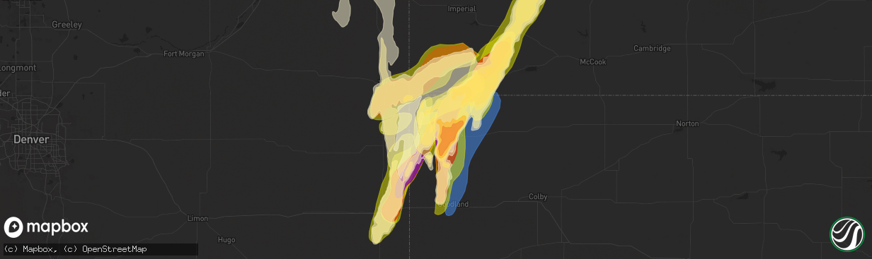
Hail Map in Saint Francis, KS on May 18, 2025
The weather event in Saint Francis, KS on May 18, 2025 includes Wind, Hail, and Tornado maps. 14 states and 906 cities were impacted and suffered possible damage. The total estimated number of properties impacted is 3,429.
Wind
Hail
Tornado
3,429
Estimated number of impacted properties by a 1.00" hail or larger3,937
Estimated number of impacted properties by a 1.75" hail or larger0
Estimated number of impacted properties by a 2.50" hail or largerStorm reports in Saint Francis, KS
Saint Francis, KS
| Date | Description |
|---|---|
| 05/18/20256:02 PM CDT | A local report indicates 2.00 inch wind near 3 SSE Saint Francis |
| 05/18/20256:00 PM CDT | Delayed entry. Social media report with picture of 2 inch hail on cr 15. |
| 05/18/20255:55 PM CDT | Report from mping: golf ball |
| 05/18/20255:50 PM CDT | Delayed entry. Social media report with picture of golf ball sized hail. |
| 05/18/20255:41 PM CDT | Spotter reports hail up to golf ball in northern portion of saint francis. |
| 05/18/20255:38 PM CDT | Report from mping: ping pong ball |
| 05/18/20255:36 PM CDT | Report from mping: golf ball |
| 05/18/20255:35 PM CDT | Report from mping: half dollar |
| 05/18/20255:35 PM CDT | Report from mping: half dollar |
| 05/18/20255:35 PM CDT | Off duty nws employee reports hailstones still on the ground up to 2 inches in size. Time estimated from radar. |
| 05/18/20255:35 PM CDT | A local report indicates 2.00 inch wind near 1 S Wheeler |
| 05/18/20255:33 PM CDT | Report from mping: quarter |
| 05/18/20255:33 PM CDT | Report from mping: quarter |
| 05/18/20255:25 PM CDT | Report of damage to a homestead. Time estimated from radar. |
| 05/18/20255:15 PM CDT | Em relayed damage to a building on road j near road 6 & 7. |
| 05/17/20257:32 PM CDT | Relayed report of quarter sized hail. |
All States Impacted by Hail Map on May 18, 2025
All Cities Impacted by Hail Map on May 18, 2025
- Northport, AL
- Coker, AL
- Echola, AL
- Elrod, AL
- Gordo, AL
- Buhl, AL
- Adger, AL
- Brookwood, AL
- Tuscaloosa, AL
- Cottondale, AL
- Dolomite, AL
- Birmingham, AL
- Bessemer, AL
- Pleasant Grove, AL
- Woodstock, AL
- West Blocton, AL
- Helena, AL
- Brierfield, AL
- McCalla, AL
- Vance, AL
- Alpine, AL
- Munford, AL
- Ashland, AL
- Sylacauga, AL
- Delta, AL
- Lincoln, AL
- Oxford, AL
- Eastaboga, AL
- Talladega, AL
- Lineville, AL
- Harpersville, AL
- Childersburg, AL
- Sterrett, AL
- Vincent, AL
- Columbiana, AL
- Wilsonville, AL
- Cropwell, AL
- Cabot, AR
- Lonoke, AR
- Daviston, AL
- Cragford, AL
- Wadley, AL
- Goodwater, AL
- Alexander City, AL
- Carlisle, AR
- Hazen, AR
- Roanoke, AL
- Lafayette, AL
- Stuttgart, AR
- Millerville, AL
- Camp Hill, AL
- De Valls Bluff, AR
- Roe, AR
- Clarendon, AR
- Five Points, AL
- Holly Grove, AR
- Brinkley, AR
- Lanett, AL
- Lyon, MS
- Mellwood, AR
- Clarksdale, MS
- Crumrod, AR
- Elaine, AR
- Pryor, OK
- Adair, OK
- Tuskegee, AL
- Marks, MS
- Alligator, MS
- Hatchechubbee, AL
- Union Springs, AL
- Duncan, MS
- Tutwiler, MS
- Vance, MS
- Charleston, MS
- Lambert, MS
- Seale, AL
- Fort Mitchell, AL
- Cascilla, MS
- Holcomb, MS
- Enid, MS
- Wedowee, AL
- Franklin, GA
- Hogansville, GA
- Lagrange, GA
- Molena, GA
- Greenville, GA
- Concord, GA
- Gay, GA
- Woodbury, GA
- Warm Springs, GA
- Waverly Hall, GA
- Manchester, GA
- West Point, GA
- Thomaston, GA
- Hamilton, GA
- Pine Mountain, GA
- Pine Mountain Valley, GA
- Woodland, GA
- Shiloh, GA
- Talbotton, GA
- Meansville, GA
- Yatesville, GA
- The Rock, GA
- Roberta, GA
- Knoxville, GA
- Culloden, GA
- Lizella, GA
- Butler, GA
- Musella, GA
- Fort Valley, GA
- Junction City, GA
- Reynolds, GA
- Byron, GA
- Scobey, MS
- Grenada, MS
- Coffeeville, MS
- Tillatoba, MS
- Macon, GA
- Bonaire, GA
- Warner Robins, GA
- Centerville, GA
- Kathleen, GA
- Spavinaw, OK
- Salina, OK
- West Point, MS
- Prairie, MS
- Porter, OK
- Wagoner, OK
- Aberdeen, MS
- Chouteau, OK
- Vian, OK
- Locust Grove, OK
- Tahlequah, OK
- Hulbert, OK
- Bunch, OK
- Sallisaw, OK
- Peggs, OK
- Cleveland, OK
- Hominy, OK
- Pawnee, OK
- Stilwell, OK
- Rose, OK
- Colcord, OK
- Muldrow, OK
- Dadeville, AL
- Junction, TX
- Eucha, OK
- Tulsa, OK
- Sapulpa, OK
- Jay, OK
- Lincoln, AR
- Summers, AR
- Uniontown, AR
- Skiatook, OK
- Westville, OK
- Harper, TX
- Sperry, OK
- Collinsville, OK
- Cedarville, AR
- Rudy, AR
- Van Buren, AR
- Chester, AR
- Hoboken, GA
- Nahunta, GA
- Owasso, OK
- Mountainburg, AR
- Catoosa, OK
- Ramona, OK
- Vera, OK
- Barnsdall, OK
- Claremore, OK
- Huntsville, AL
- Sulphur Springs, AR
- Bella Vista, AR
- Noel, MO
- Inola, OK
- Burnet, TX
- Gravette, AR
- Talala, OK
- Pineville, MO
- Newcastle, WY
- Rock River, WY
- Bertram, TX
- Lampasas, TX
- Strang, OK
- Parker, CO
- Aurora, CO
- Watkins, CO
- Killeen, TX
- Oologah, OK
- Vinita, OK
- Chelsea, OK
- Big Cabin, OK
- Conway Springs, KS
- Garrett, WY
- Bennett, CO
- Milton, KS
- Viola, KS
- Goddard, KS
- Cheney, KS
- Garden Plain, KS
- Livermore, CO
- Huntsville, AR
- Colwich, KS
- Andale, KS
- Maize, KS
- Valley Center, KS
- Sedgwick, KS
- Bosler, WY
- Clearwater, KS
- Wichita, KS
- Roggen, CO
- Longmont, CO
- Laporte, CO
- Wellington, CO
- Thorsby, AL
- Maplesville, AL
- Clanton, AL
- Kansas, OK
- Twin Oaks, OK
- Snyder, CO
- Mount Hope, KS
- Maysville, AR
- Oaks, OK
- Watts, OK
- Siloam Springs, AR
- Gentry, AR
- Stoneham, CO
- Merino, CO
- Carr, CO
- Golden, CO
- Wesley, AR
- Haven, KS
- Burrton, KS
- Wiggins, CO
- Otis, CO
- Decatur, AR
- Bentonville, AR
- Sedan, KS
- Delaware, OK
- Nowata, OK
- Derby, KS
- Atlanta, KS
- Burden, KS
- Copan, OK
- Rose Hill, KS
- Douglass, KS
- Wann, OK
- Dewey, OK
- Fayetteville, AR
- Springdale, AR
- Eldorado Springs, CO
- Boulder, CO
- Weldona, CO
- Sterling, CO
- Abilene, TX
- Halstead, KS
- Albany, TX
- Lueders, TX
- Dyess Afb, TX
- Tye, TX
- Lowell, AR
- Burlington, CO
- Rogers, AR
- Louisville, CO
- Lafayette, CO
- Fort Morgan, CO
- Orchard, CO
- New Raymer, CO
- Briggsdale, CO
- Grover, CO
- Winters, TX
- Otter, MT
- Padroni, CO
- Hesston, KS
- Centerton, AR
- Wheatland, WY
- Prairie Grove, AR
- Ovalo, TX
- Newton, KS
- Moundridge, KS
- Berryville, AR
- Eureka Springs, AR
- Hindsville, AR
- Canadian, TX
- Cedar Vale, KS
- Lawn, TX
- Elkins, AR
- Cave Springs, AR
- Clyde, TX
- Peetz, CO
- Sidney, NE
- Erie, CO
- Tuscola, TX
- Goodland, KS
- Lipscomb, TX
- Follett, TX
- Higgins, TX
- Leoti, KS
- Idalia, CO
- Box Elder, SD
- Bee Branch, AR
- Center Ridge, AR
- Damascus, AR
- Throckmorton, TX
- Hays, KS
- Pfeifer, KS
- Potter, NE
- Dix, NE
- Victoria, KS
- Kanorado, KS
- Wray, CO
- Saint Francis, KS
- Chase, KS
- Raymond, KS
- Laverne, OK
- Pine Bluffs, WY
- Decker, MT
- Green Forest, AR
- Lyons, KS
- Gorham, KS
- Paradise, KS
- Iliff, CO
- Crook, CO
- Shattuck, OK
- Stratton, CO
- Witter, AR
- Arnett, OK
- Bushton, KS
- Lorraine, KS
- Holyrood, KS
- Bird City, KS
- Edson, KS
- Kirk, CO
- Yuma, CO
- Joes, CO
- Ellsworth, KS
- Eckley, CO
- Wilson, KS
- Birney, MT
- Russell, KS
- Winona, KS
- West Fork, AR
- Natoma, KS
- Plainville, KS
- Marienthal, KS
- Scott City, KS
- Kechi, KS
- Quitman, AR
- Bushnell, NE
- Dorrance, KS
- Bunker Hill, KS
- Ellinwood, KS
- Farmington, AR
- Baird, TX
- Newcastle, TX
- Sylvan Grove, KS
- Geneseo, KS
- Holyoke, CO
- Alton, KS
- Gaylord, KS
- Osborne, KS
- Burns, WY
- Hillsdale, WY
- Carpenter, WY
- Hereford, CO
- Cheyenne, WY
- Nunn, CO
- Albin, WY
- Meriden, WY
- Harrisburg, NE
- Kimball, NE
- Gurley, NE
- Lagrange, WY
- Waldo, KS
- Oakley, KS
- Lodgepole, NE
- Ten Sleep, WY
- Jasper, AR
- Vendor, AR
- Neodesha, KS
- Lucas, KS
- Luray, KS
- Little River, KS
- Parthenon, AR
- Haigler, NE
- Severy, KS
- Kingston, AR
- Monument, KS
- Smith Center, KS
- Cedar, KS
- Athol, KS
- Haxtun, CO
- Paoli, CO
- Amherst, CO
- Sedgwick, CO
- Ovid, CO
- Vernon, CO
- Rosston, OK
- Buffalo, OK
- Ashland, KS
- Whitewater, KS
- Dalton, NE
- Cimarron, KS
- Peabody, KS
- Walton, KS
- Eureka, KS
- Broomfield, CO
- Lincoln, KS
- Breckenridge, TX
- Portis, KS
- Deer, AR
- Kanopolis, KS
- Windom, KS
- Toronto, KS
- Altoona, KS
- El Dorado, KS
- Moran, TX
- Gate, OK
- Ingalls, KS
- Durham, OK
- Dighton, KS
- Minneola, KS
- Alliance, NE
- Hemingford, NE
- Mitchell, NE
- Torrington, WY
- Yoder, WY
- Gering, NE
- Morrill, NE
- Lyman, NE
- Hawk Springs, WY
- Harrison, NE
- Minatare, NE
- Mcgrew, NE
- Bayard, NE
- Melbeta, NE
- Scottsbluff, NE
- Bridgeport, NE
- Angora, NE
- Broadwater, NE
- Lisco, NE
- Sharon, OK
- Burns, KS
- Graham, TX
- Marquette, KS
- Marion, KS
- Hillsboro, KS
- Hunter, KS
- Tipton, KS
- Beloit, KS
- Glade, KS
- Kirwin, KS
- Cassoday, KS
- Julesburg, CO
- Cisco, TX
- Brookville, KS
- Falun, KS
- Parks, NE
- Benkelman, NE
- Max, NE
- Stratton, NE
- Kensington, KS
- Riverton, NE
- Franklin, NE
- Bloomington, NE
- McDonald, KS
- Lincolnville, KS
- Randall, KS
- Tampa, KS
- Ramona, KS
- Lost Springs, KS
- Madison, KS
- Hamilton, KS
- Downs, KS
- Glen Elder, KS
- Cawker City, KS
- Bucklin, KS
- Mankato, KS
- Burr Oak, KS
- Virgil, KS
- Grinnell, KS
- Barnard, KS
- Lindsborg, KS
- Robert Lee, TX
- Salina, KS
- Woodward, OK
- Big Springs, NE
- Chappell, NE
- Oshkosh, NE
- Fargo, OK
- Hope, KS
- Herington, KS
- Woodbine, KS
- Chapman, KS
- Junction City, KS
- Enterprise, KS
- Ranger, TX
- Guide Rock, NE
- Republican City, NE
- Upland, NE
- Courtland, KS
- Orleans, NE
- Jewell, KS
- Esbon, KS
- Eastland, TX
- Beeler, KS
- Hildreth, NE
- Oxford, NE
- Alma, NE
- Ness City, KS
- Assaria, KS
- New Cambria, KS
- Colby, KS
- Caddo, TX
- Marsland, NE
- Lewellen, NE
- Wauneta, NE
- Palisade, NE
- Imperial, NE
- Bertrand, NE
- Atlanta, NE
- Holdrege, NE
- Utica, KS
- Loomis, NE
- Offerle, KS
- Hoxie, KS
- Simpson, KS
- Jacksboro, TX
- Kinsley, KS
- Lebanon, KS
- Burdick, KS
- Solomon, KS
- Fort Supply, OK
- Smithfield, NE
- Lexington, NE
- Overton, NE
- Eddyville, NE
- Sumner, NE
- Elwood, NE
- Mooreland, OK
- Strawn, TX
- Arnold, KS
- Perrin, TX
- White City, KS
- Sterling City, TX
- Ellsworth, NE
- Enders, NE
- Minden, NE
- Eustis, NE
- Graford, TX
- Madrid, NE
- Olpe, KS
- Emporia, KS
- Grainfield, KS
- Ransom, KS
- Hayes Center, NE
- Collyer, KS
- Wakeeney, KS
- Cozad, NE
- Gordon, TX
- Kearney, NE
- Heartwell, NE
- Gibbon, NE
- Kenesaw, NE
- Wood River, NE
- Shelton, NE
- Abilene, KS
- Elsie, NE
- Garfield, KS
- Lewis, KS
- Jamestown, KS
- Concordia, KS
- Paradise, TX
- Bridgeport, TX
- Ogallah, KS
- Council Grove, KS
- Palo Pinto, TX
- Lakeside, NE
- Bingham, NE
- Oconto, NE
- Callaway, NE
- Broken Bow, NE
- Merna, NE
- Anselmo, NE
- Longford, KS
- Wakefield, KS
- Larned, KS
- Brady, NE
- Gothenburg, NE
- Ellis, KS
- Greenbrier, AR
- Woodston, KS
- Selden, KS
- Guy, AR
- Scandia, KS
- Norway, KS
- Santo, TX
- Decatur, TX
- Mingus, TX
- Mineral Wells, TX
- Maxwell, NE
- Stapleton, NE
- Ravenna, NE
- Cairo, NE
- Freedom, OK
- Paxton, NE
- Wallace, NE
- Morland, KS
- Millsap, TX
- Clay Center, KS
- Dickens, NE
- Judsonia, AR
- Searcy, AR
- Palco, KS
- Lebo, KS
- Bluff Dale, TX
- Stephenville, TX
- Lipan, TX
- Tryon, NE
- Arnold, NE
- Dunning, NE
- Bronte, TX
- Boelus, NE
- Dannebrog, NE
- Grand Island, NE
- Wellfleet, NE
- North Platte, NE
- Weatherford, TX
- Belleville, KS
- Agenda, KS
- Cuba, KS
- McCrory, AR
- Augusta, AR
- Hill City, KS
- Lenora, KS
- Wynne, AR
- Colt, AR
- Cotton Plant, AR
- Riley, KS
- Milford, KS
- Leonardville, KS
- Sanger, TX
- Pawnee Rock, KS
- Justin, TX
- Krum, TX
- Chico, TX
- Rose Bud, AR
- Romance, AR
- Alva, OK
- Coldwater, KS
- Penokee, KS
- Norton, TX
- Bald Knob, AR
- Palestine, AR
- Hunter, AR
- McRae, AR
- Beebe, AR
- Gainesville, TX
- Kensett, AR
- Garner, AR
- Higginson, AR
- Hershey, NE
- Lake City, KS
- Narka, KS
- Wheatley, AR
- Rhome, TX
- Griffithville, AR
- Stockton, KS
- Spearville, KS
- Almena, KS
- Granbury, TX
- Tolar, TX
- Superior, NE
- Westphalia, KS
- Great Bend, KS
- Waynoka, OK
- Trenton, NE
- Mullinville, KS
- Hubbell, NE
- Reynolds, NE
- Lawrence, NE
- Nelson, NE
- Ponder, TX
- Argyle, TX
- Denton, TX
- Munden, KS
- Prairie View, KS
- Mahaska, KS
- Fairbury, NE
- Hoisington, KS
- Randolph, KS
- Forrest City, AR
- Humboldt, KS
- La Harpe, KS
- Sutherland, NE
- Oak, NE
- Heth, AR
- Proctor, AR
- Marianna, AR
- Widener, AR
- Long Island, KS
- Phillipsburg, KS
- Chanute, KS
- Claflin, KS
- Aledo, TX
- Haviland, KS
- Memphis, TN
- Atwood, KS
- West Memphis, AR
- Edgar, NE
- Iola, KS
- Talpa, TX
- Greensburg, KS
- Frankfort, KS
- Hughes, AR
- Brickeys, AR
- Culbertson, NE
- Elizabeth, CO
- Strasburg, CO
- Byers, CO
- Aubrey, TX
- Prosper, TX
- Shickley, NE
- Frisco, TX
- Robinsonville, MS
- Davenport, NE
- Coleman, TX
- Novice, TX
- Plymouth, NE
- Jansen, NE
- Olmitz, KS
- Belpre, KS
- Agra, KS
- Daykin, NE
- Log Lane Village, CO
- Kersey, CO
- Albert, KS
- Little Elm, TX
- Keenesburg, CO
- Hudson, CO
- Mckinney, TX
- Celina, TX
- Ong, NE
- Naponee, NE
- Lake Cormorant, MS
- Erie, KS
- Saint Paul, KS
- Hernando, MS
- Vermillion, KS
- Geneva, NE
- Coldwater, MS
- Tunica, MS
- Walls, MS
- McCook, NE
- Nesbit, MS
- Burkett, TX
- Brownwood, TX
- Cross Plains, TX
- Pratt, KS
- Stark, KS
- Oberlin, KS
- May, TX
- Iuka, KS
- Byhalia, MS
- Holly Springs, MS
- Byers, KS
- Turon, KS
- Stafford, KS
- Cresson, TX
- St John, KS
- Alvord, TX
- Waterford, MS
- Danbury, NE
- Inavale, NE
- Senatobia, MS
- Glasco, KS
- Potts Camp, MS
- Hepler, KS
- Uniontown, KS
- Red Cloud, NE
- Hickory Flat, MS
- Purdum, NE
- Brewster, NE
- Bassett, NE
- Ansley, NE
- Taylor, NE
- Westerville, NE
- Comstock, NE
- Ainsworth, NE
- Sargent, NE
- Elyria, NE
- Burwell, NE
- Ord, NE
- Sylvia, KS
- Plevna, KS
- Ponca, AR
- Moran, KS
- Dennis, MS
- Belmont, MS
- New Site, MS
- Golden, MS
- Redfield, KS
- Delphos, KS
- Amelia, NE
- Willow Island, NE
- Elm Creek, NE
- Mason City, NE
- Miller, NE
- Amherst, NE
- Loup City, NE
- Pleasanton, NE
- Litchfield, NE
- Riverdale, NE
- Arcadia, NE
- Hazard, NE
- Ashton, NE
- North Loup, NE
- Rockville, NE
- Farwell, NE
- Savonburg, KS
- Tishomingo, MS
- Blue Mountain, MS
- Haddam, KS
- Myrtle, MS
- New Albany, MS
- Abbyville, KS
- Lockwood, MO
- Iuka, MS
- Bronson, KS
- Jerico Springs, MO
- Kincaid, KS
- Stockton, MO
- Arcola, MO
- Ripley, MS
- Nickerson, KS
- Saint Paul, NE
- Bartlett, NE
- Greeley, NE
- Ericson, NE
- Ewing, NE
- Atkinson, NE
- Scotia, NE
- Elba, NE
- Wolbach, NE
- Chambers, NE
- Palmer, NE
- Saint Libory, NE
- Sterling, KS
- Crete, NE
- Cherokee, AL
- Richards, MO
- Booneville, MS
- Dumas, MS
- Spalding, NE
- Cedar Rapids, NE
- Primrose, NE
- Logan, KS
- Fort Scott, KS
- Allen, KS
- Blue Springs, NE
- Wymore, NE
- Alma, KS
- Beatrice, NE
- Odell, NE
- Mcpherson, KS
- Hodges, AL
- Minneapolis, KS
- Green, KS
- Eskridge, KS
- Filley, NE
- Red Bay, AL
- Fullerton, NE
- Belgrade, NE
- Topeka, KS
- Maple Hill, KS
- Harveyville, KS
- Russellville, AL
- Adams, NE
- Crab Orchard, NE
- Auburn, KS
- Virginia, NE
- Tecumseh, NE
- Sterling, NE
- Lewiston, NE
- Madison, AL
- Steinauer, NE
- Silver Lake, KS
- Elk Creek, NE
- Meriden, KS
- Grantville, KS
- Oskaloosa, KS
- Ozawkie, KS
- Maryneal, TX
- Blackwell, TX
- Roscoe, TX
- Moulton, AL
- Excelsior Springs, MO
- Orrick, MO
- Hartselle, AL
- Missouri City, MO
- Rayville, MO
- Formoso, KS
- Clyde, KS
- Sutton, NE
- Grafton, NE


