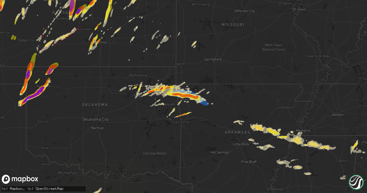
Hail Map on May 18, 2025
Get this storm
May 18 map
$229
one time, instant access
Download today. No call, no setup
Keep the $229
Bought the map and want the full workflow? Apply the entire $229 to a subscription within 7 days. None of it is wasted.
Every map, not just this one
This buys you this map. Subscription and you get every map we run, in the markets you choose from a few cities to whole states to nationwide. Plus real-time alerts the moment a storm fires.
Contact data
Name, contact info, occupancy, even credit band for addresses in the footprint. You go from where it hit to who to call.
Become the source they trust
Unlimited branding weather history reports on demand. You already have the documented answer ready for the property owner, and you are the one who showed up with it.
Property data and RoofTrace estimates
Pull up any address you have got, its value and the exact code rules for that jurisdiction, straight from One Click Code. Then RoofTrace estimates the squares, pitch, and roof value, priced the way you price.
States Impacted by Hail Map on May 18, 2025
Storm reports
Texas
| Date | Description |
|---|---|
| 05/18/20256:52 PM CDT | Quarter sized hail in harpersville. |
| 05/18/20256:40 PM CDT | Public report of quarter size hail on office social media page. |
| 05/18/20255:23 PM CDT | Reports of tornado south of higgins. |
| 05/18/20255:19 PM CDT | Delayed report: tree damage and downed power poles/lines approximately 6 miles north and east of the city of albany in a rural portion of the county county road 109 eas |
| 05/18/20255:14 PM CDT | Firefighter around 12 miles south of higgins reported baseball size hail. |
| 05/18/20255:03 PM CDT | Delayed report: video and report of a tornado a few miles south of clyde near fm 604. Report of a lot of tree damage associated with this tornado. Time and exact locati |
| 05/18/20255:02 PM CDT | A local report indicates 2.00 inch wind near Tuscola |
| 05/18/20255:02 PM CDT | A local report indicates 2.00 inch wind near Tuscola |
| 05/18/20255:02 PM CDT | A local report indicates 2.50 inch wind near Tuscola |
| 05/18/20254:59 PM CDT | A local report indicates 1.75 inch wind near 7 S Follett |
| 05/17/20259:49 PM CDT | 67 mph gust measured at guinn hall twu. |
| 05/17/20259:33 PM CDT | Numerous trees and tree limbs blown down across denton. |
| 05/17/20258:29 PM CDT | Report from mping: quarter |
| 05/17/20258:27 PM CDT | Golf ball sized hail near i-20 at mile marker 384. |
| 05/17/20258:27 PM CDT | Report from mping: quarter |
| 05/17/20258:27 PM CDT | Golf |
| 05/17/20258:24 PM CDT | A local report indicates 2.00 inch wind near 7 SSW Millsap |
| 05/17/20258:07 PM CDT | Report from mping: quarter |
| 05/17/20257:50 PM CDT | Report from mping: half dollar |
| 05/17/20257:16 PM CDT | Tennis ball sized hail in la casa. |
Wyoming
| Date | Description |
|---|---|
| 05/18/20254:46 PM CDT | A local report indicates 1.00 inch wind near 3 E Wheatland |
Kansas
| Date | Description |
|---|---|
| 05/18/20256:55 PM CDT | A local report indicates 1.00 inch wind near 3 SW Junction City |
| 05/18/20256:55 PM CDT | Tds observed on radar. |
| 05/18/20256:55 PM CDT | Report from the emergency manager that the town of grinnell was hit by a tornado. |
| 05/18/20256:52 PM CDT | A local report indicates 1.50 inch wind near Beloit |
| 05/18/20256:51 PM CDT | A local report indicates 1.50 inch wind near 2 S Salina |
| 05/18/20256:51 PM CDT | Report on social media of ping pong ball size hail in beloit. |
| 05/18/20256:45 PM CDT | Time and location estimated from radar. |
| 05/18/20256:43 PM CDT | A local report indicates 1.50 inch wind near 4 NNW Woodbine |
| 05/18/20256:43 PM CDT | Received via mping. |
| 05/18/20256:42 PM CDT | A local report indicates 1.00 inch wind near 1 SSW Woodbine |
| 05/18/20256:35 PM CDT | Storm spotter network report of one inch hail. |
| 05/18/20256:35 PM CDT | Storm chaser video of tornado on the ground near gove... Ks. |
| 05/18/20256:33 PM CDT | A local report indicates 1.00 inch wind near Herington |
| 05/18/20256:31 PM CDT | A local report indicates 1.25 inch wind near 12 N Bird City |
| 05/18/20256:30 PM CDT | Delayed report from last night via social media. Corrected for hail size. |
| 05/18/20256:22 PM CDT | A local report indicates 1.00 inch wind near 6 WNW Lost Springs |
| 05/18/20256:19 PM CDT | 3350_ |
| 05/18/20256:19 PM CDT | 3350_(awn |
| 05/18/20256:16 PM CDT | Social media report |
| 05/18/20256:15 PM CDT | Report of 1 inch hail north of bird city. |
| 05/18/20256:10 PM CDT | Emergency manager confirmed tornado. |
| 05/18/20256:08 PM CDT | Approximately 15 rail cars blown over and power lines damaged. May be from a possible tornado. |
| 05/18/20256:02 PM CDT | A local report indicates 2.00 inch wind near 3 SSE Saint Francis |
| 05/18/20256:01 PM CDT | Mping report. |
| 05/18/20256:00 PM CDT | Delayed entry. Social media report with picture of 2 inch hail on cr 15. |
| 05/18/20255:57 PM CDT | A local report indicates 1.25 inch wind near 8 WNW Marquette |
| 05/18/20255:55 PM CDT | Report from mping: golf ball |
| 05/18/20255:52 PM CDT | A local report indicates 1.00 inch wind near 3 E Ingalls |
| 05/18/20255:50 PM CDT | Delayed entry. Social media report with picture of golf ball sized hail. |
| 05/18/20255:50 PM CDT | A local report indicates 1.25 inch wind near 5 N Sylvan Grove |
| 05/18/20255:49 PM CDT | Tds noted on radar. |
| 05/18/20255:45 PM CDT | Mesonet station up840 9.0 w winona |
| 05/18/20255:45 PM CDT | Up840. |
| 05/18/20255:44 PM CDT | This report included video of the tornado. |
| 05/18/20255:41 PM CDT | Spotter reports hail up to golf ball in northern portion of saint francis. |
| 05/18/20255:39 PM CDT | A local report indicates 1.75 inch wind near Geneseo |
| 05/18/20255:38 PM CDT | A local report indicates 1.50 inch wind near 1 W Geneseo |
| 05/18/20255:38 PM CDT | Report from mping: ping pong ball |
| 05/18/20255:38 PM CDT | Spotter reports quarter sized hail in alton. |
| 05/18/20255:36 PM CDT | Report from mping: golf ball |
| 05/18/20255:35 PM CDT | Report from mping: half dollar |
| 05/18/20255:35 PM CDT | Report from mping: half dollar |
| 05/18/20255:35 PM CDT | Off duty nws employee reports hailstones still on the ground up to 2 inches in size. Time estimated from radar. |
| 05/18/20255:35 PM CDT | A local report indicates 2.00 inch wind near 1 S Wheeler |
| 05/18/20255:34 PM CDT | Photo sent in by emergency manager... Public report. |
| 05/18/20255:33 PM CDT | Report from mping: quarter |
| 05/18/20255:33 PM CDT | Report from mping: quarter |
| 05/18/20255:31 PM CDT | A local report indicates 1.75 inch wind near 5 WSW Scott State Lake |
| 05/18/20255:28 PM CDT | Spotter reports quarter size hail south of alton. |
| 05/18/20255:27 PM CDT | Report from mping: quarter |
| 05/18/20255:25 PM CDT | Report of damage to a homestead. Time estimated from radar. |
| 05/18/20255:19 PM CDT | A local report indicates 2.00 inch wind near Holyrood |
| 05/18/20255:16 PM CDT | Off duty nws employee reported a tornado 7 miles north of kanorado |
| 05/18/20255:15 PM CDT | A local report indicates 1.00 inch wind near Bushton |
| 05/18/20255:15 PM CDT | Em relayed damage to a building on road j near road 6 & 7. |
| 05/18/20255:06 PM CDT | Asos station kgld goodland measured a 60 mph |
| 05/18/20254:58 PM CDT | Asos station kgld goodland measured a 58 mph wind gust at 3:58 pm mdt |
| 05/18/20254:58 PM CDT | Asos station kgld goodla |
| 05/18/20254:55 PM CDT | Delayed report. Report of quarter sized hail. Time estimated from radar. |
| 05/18/20254:52 PM CDT | A local report indicates 1.25 inch wind near 1 SSE Ruleton |
| 05/18/20254:26 PM CDT | A local report indicates 1.50 inch wind near 1 NW Hesston |
| 05/18/20253:29 PM CDT | Near 13th and west... Courtesy of kake tv. |
| 05/18/20253:28 PM CDT | Near 9th and zoo boulevard. |
| 05/18/20253:25 PM CDT | Near kellogg and ridge. |
| 05/18/20253:24 PM CDT | Half dollar size hail at nws office. |
| 05/18/20253:15 PM CDT | A local report indicates 1.50 inch wind near Colwich |
| 05/18/20252:59 PM CDT | A local report indicates 1.25 inch wind near 2 E Garden Plain |
| 05/17/202511:50 PM CDT | Home destroyed and power lines down. |
| 05/17/202511:42 PM CDT | Off duty nws employee reports a very large tornado. Radar also shows a very large debris signature. |
| 05/17/202511:40 PM CDT | A local report indicates a tornado near Neola |
| 05/17/202511:23 PM CDT | Storm chaser photo of large tornado along with debris signature on radar. |
| 05/17/202511:05 PM CDT | Trees shredded and powerlines and poles snaped. Tornado damage possible. |
| 05/17/202510:55 PM CDT | Several powerlines down at this location. Possible tornado. |
| 05/17/20259:53 PM CDT | Report included pictures. |
| 05/17/20259:38 PM CDT | A local report indicates a tornado near 11 SE Mullinville |
| 05/17/20258:11 PM CDT | A local report indicates 1.75 inch wind near 7 W Wakefield |
| 05/17/20258:11 PM CDT | 1.5 to 2.5 inch diameter limbs down. |
| 05/17/20258:07 PM CDT | A local report indicates 1.00 inch wind near 7 S New Almelo |
| 05/17/20257:57 PM CDT | A local report indicates 1.75 inch wind near 5 N Ellis |
| 05/17/20257:55 PM CDT | Asos station kcnk concordia. |
| 05/17/20257:50 PM CDT | Videos of the tornado from the broadcast media. |
| 05/17/20257:47 PM CDT | A local report indicates 1.00 inch wind near Ogallah |
| 05/17/20257:34 PM CDT | Dime to quarter size hail. |
| 05/17/20257:32 PM CDT | Relayed report of quarter sized hail. |
| 05/17/20257:31 PM CDT | Live streaming video of tornado was on kake-tv. |
| 05/17/20257:30 PM CDT | Report of half dollar sized hail in hoxie. |
| 05/17/20257:07 PM CDT | Chaser report of one inch hail on interstate 70. |
| 05/17/20257:06 PM CDT | Possible tornado. Delayed report of powerlines down for a mile along w road 90 s. Time estimated. |
| 05/17/20257:05 PM CDT | Report on social media of ping pong ball sized hail in beloit. |
| 05/17/20257:05 PM CDT | Possible tornado. Delayed report of damage to a building along road s 40w. Time estimated. |
| 05/17/20257:02 PM CDT | Multiple reports of tornado just east of grinnell. One report of it roping out. |
Colorado
| Date | Description |
|---|---|
| 05/18/20256:53 PM CDT | Asos station kitr burlington co airport. |
| 05/18/20256:03 PM CDT | A local report indicates 70 MPH wind near 3 ENE Marks Butte |
| 05/18/20255:53 PM CDT | A local report indicates 63 MPH wind near 4 W Fairfield |
| 05/18/20255:38 PM CDT | Half inch to one hail hail covering the ground. |
| 05/18/20255:17 PM CDT | Social media report of quarter sized hail. |
| 05/18/20255:15 PM CDT | Storm chaser reported hen egg sized hail ~11 miles nne of burlington at approximately 4:15 pm mdt |
| 05/18/20255:15 PM CDT | Pws-kcowray7. |
| 05/18/20255:08 PM CDT | Observer reported hail ranging from nickel to golf ball in size. |
| 05/18/20255:05 PM CDT | Delayed entry. Social media report with picture of a tornado north of kirk. Potential landspout. |
| 05/18/20255:04 PM CDT | Spotter reported quarter sized hail 7 miles se of wray at approximately 4:05 pm mdt |
| 05/18/20254:55 PM CDT | Awos station k1ow 2 nw pawnee buttes. |
| 05/18/20254:51 PM CDT | Social media report with video of hail quarter to half dollar in size. |
| 05/18/20254:51 PM CDT | Social media report with video of hail quarter to half dollar in size. |
| 05/18/20254:40 PM CDT | Social media report of hail up to golf ball in size with pictures. |
| 05/18/20254:36 PM CDT | A local report indicates 60 MPH wind near 4 NW Pawnee Buttes |
| 05/18/20254:32 PM CDT | Report from mping: half dollar |
| 05/18/20254:32 PM CDT | Report from mping: half dollar |
| 05/18/20254:16 PM CDT | Picture of 1 inch hail on x. |
| 05/18/20253:51 PM CDT | A local report indicates 58 MPH wind near 6 SW Log Lane Village |
| 05/18/20253:46 PM CDT | A local report indicates 66 MPH wind near 4 SSW Orchard |
| 05/18/20252:56 PM CDT | A local report indicates 66 MPH wind near 5 NNE Bennett |
| 05/18/20252:43 PM CDT | Tornado on ground with debris being lofted. |
| 05/18/20252:43 PM CDT | Tornado on ground 1:43pm to 1:58pm |
| 05/18/20252:37 PM CDT | Tornado on ground. |
| 05/18/20252:28 PM CDT | Tornado on ground from 1:28pm to 1:34pm. |
| 05/18/20252:28 PM CDT | Tornado on ground from 1:28pm to 1:34pm |
| 05/18/20252:28 PM CDT | Tornado on ground. |
| 05/18/20252:25 PM CDT | Report from mping: ping pong ball |
| 05/18/20252:23 PM CDT | A local report indicates 70 MPH wind near 7 SSE Watkins |
| 05/18/20252:11 PM CDT | Report from mping: half dollar |
| 05/18/20252:08 PM CDT | Tornado on ground from 1:08pm until 1:17pm. |
| 05/18/20252:08 PM CDT | Corrects previous tornado report from 5 se arapahoe park. Tornado on ground from 1:08pm until 1:17pm |
| 05/18/20252:08 PM CDT | Tornado on ground from 1:08pm until 1:17pm |
| 05/17/20257:12 PM CDT | Relayed report of hail up to half dollar in size. Time estimated from radar. |
| 05/17/20257:09 PM CDT | Report of quarter sized hail in wray. |
Nebraska
| Date | Description |
|---|---|
| 05/18/20256:59 PM CDT | Weak tornado crossed hwy 34 roughly here; downed power lines and tipped over pivots. |
| 05/18/20256:57 PM CDT | Video of a tornado moving over highway 34. |
| 05/18/20256:54 PM CDT | Off duty nws employee reported tornado just east of max and north of highway 34. |
| 05/18/20256:47 PM CDT | Report of golf ball sized hail just west of max... Ne. |
| 05/18/20256:39 PM CDT | A local report indicates 61 MPH wind near 10 N Chappell |
| 05/18/20256:38 PM CDT | Report from mping: golf ball |
| 05/18/20256:37 PM CDT | Report from mping: ping pong ball |
| 05/18/20256:32 PM CDT | Report from mping: quarter |
| 05/18/20256:28 PM CDT | Trained spotter reports hail up to 2 inches with photos. |
| 05/18/20256:27 PM CDT | Report from mping: quarter |
| 05/18/20256:16 PM CDT | A local report indicates 71 MPH wind near Scottsbluff |
| 05/18/20256:07 PM CDT | A local report indicates 1.00 inch wind near 2 N Sidney |
| 05/18/20256:06 PM CDT | A local report indicates 69 MPH wind near 4 WNW Terrytown |
| 05/18/20256:05 PM CDT | A local report indicates 69 MPH wind near Scottsbluff |
| 05/18/20255:45 PM CDT | Trained spotter reports 2 inch diameter hail. |
| 05/18/20255:35 PM CDT | A local report indicates 1.00 inch wind near 4 S Sidney |
| 05/18/20255:35 PM CDT | Trained spotter reports quarter size hail. |
| 05/18/20255:15 PM CDT | A local report indicates 70 MPH wind near Kimball |
| 05/18/20255:00 PM CDT | A local report indicates 1.00 inch wind near 8 S Potter |
| 05/18/20253:36 AM CDT | Delayed report of tree damage in clarkson... Ne. Time based on radar. |
| 05/18/20253:31 AM CDT | Delayed report of thunderstorm wind damage... Near intersection of rd 8 and rd t. Time based |
| 05/18/20253:31 AM CDT | Delayed report of thunderstorm wind damage... Near intersection of rd 8 |
| 05/18/20253:31 AM CDT | Delayed report of thunderstorm wind damage... Near intersection of rd 8 and rd t. Time based on radar. |
| 05/18/20253:30 AM CDT | Delayed report of porch/roof damage. Time estimated based on radar. |
| 05/18/202512:18 AM CDT | Delayed report of |
| 05/18/202512:18 AM CDT | Delayed report of tree limbs down relayed by local emergency management. Time estimated based on radar. |
| 05/17/202511:37 PM CDT | Emergency manager reports 60mph winds in miller. |
| 05/17/202511:30 PM CDT | A local report indicates 68 MPH wind near 4 SE Eddyville |
| 05/17/202510:48 PM CDT | A local report indicates 67 MPH wind near 5 S Anselmo |
| 05/17/202510:40 PM CDT | Time estimated by radar. |
| 05/17/202510:15 PM CDT | A local report indicates 59 MPH wind near Grand Island Airport |
| 05/17/20259:40 PM CDT | A local report indicates 63 MPH wind near 6 WNW Maxwell |
| 05/17/20259:38 PM CDT | A local report indicates 1.00 inch wind near 4 E North Platte |
| 05/17/20259:33 PM CDT | A local report indicates 59 MPH wind near 4 SE Edgar |
| 05/17/20259:32 PM CDT | A local report indicates 60 MPH wind near 3 NNW Oak |
| 05/17/20258:48 PM CDT | A local report indicates 1.00 inch wind near 2 W North Platte |
| 05/17/20258:46 PM CDT | Report from mping: baseball+ |
| 05/17/20258:20 PM CDT | A local report indicates 65 MPH wind near 6 SW Boelus |
| 05/17/20258:16 PM CDT | Report from mping: quarter |
| 05/17/20258:01 PM CDT | Possible tornado damage reported. |
| 05/17/20258:00 PM CDT | A local report indicates 61 MPH wind near 3 N Hayes Center |
| 05/17/20257:59 PM CDT | Report from mping. |
| 05/17/20257:59 PM CDT | Report from mping: golf ball |
| 05/17/20257:55 PM CDT | Spotter reports quarter sized hail. |
| 05/17/20257:49 PM CDT | A local report indicates 1.00 inch wind near 7 NNW Gibbon |
| 05/17/20257:35 PM CDT | Spotter reports quarter sized hail near darr. |
| 05/17/20257:16 PM CDT | Roof damage to home at in stratton at mm 50. |
| 05/17/20257:12 PM CDT | Report of downed power lines from spotter network. |
| 05/17/20257:07 PM CDT | Spotter reports quarter sized hail west-southwest of overton. |
| 05/17/20257:03 PM CDT | Caller reported two inch hail along with broad rotation. |
| 05/17/20257:00 PM CDT | Sheet metal in ditch... Power poles down.... |
Oklahoma
| Date | Description |
|---|---|
| 05/18/20256:59 PM CDT | Nwschat photo. |
| 05/18/20256:57 PM CDT | Report from mping: tennis ball |
| 05/18/20256:56 PM CDT | Nwschat photo. |
| 05/18/20256:56 PM CDT | A local report indicates 1.50 inch wind near 1 W Woodward |
| 05/18/20256:45 PM CDT | X post with photo. |
| 05/18/20256:42 PM CDT | Report from mping: baseball |
| 05/18/20256:42 PM CDT | Delayed report. Report from mping: quarter |
| 05/18/20256:32 PM CDT | Report from mping: tea cup |
| 05/18/20256:28 PM CDT | Report from mping: baseball |
| 05/18/20256:18 PM CDT | Photo on x with calipers. Time is radar estimate. Ing pong ball sized hail in beloit. |
| 05/18/20256:18 PM CDT | Photo on x with calipers. Time is radar estimate. |
| 05/18/20256:15 PM CDT | X post with photo. |
| 05/18/20256:11 PM CDT | Delayed report. Report from mping: grapefruit |
| 05/18/20256:08 PM CDT | Report from mping: hen egg+ |
| 05/18/20256:02 PM CDT | Twitter photo... Time is radar estimate. |
| 05/18/20256:02 PM CDT | Tornado observed by numerous storm chasers. Location is estimated. |
| 05/18/20256:02 PM CDT | Report from mping: ping pong ball |
| 05/18/20256:02 PM CDT | Corrects previous hail report from 4 ene arnett. Twitter photo... Time is radar estimate. Updated with a ruler measurement. |
| 05/18/20255:59 PM CDT | Photo transmitted through nwschat. |
| 05/18/20255:55 PM CDT | Report from mping: golf ball |
| 05/18/20255:48 PM CDT | A local report indicates 3.91 inch wind near 6 W Arnett |
| 05/18/20255:47 PM CDT | Report from mping: baseball |
| 05/18/20255:47 PM CDT | Tornado observed by numerous storm chasers. Lasted approximately 9 minutes dissipating just southwest or west of arnett. Location estimated. |
| 05/18/20255:45 PM CDT | Delayed report. Report from mping: grapefruit+ |
| 05/18/20255:45 PM CDT | Report from mping: baseball++ |
| 05/18/20255:43 PM CDT | Report from mping: tea cup |
| 05/18/20255:40 PM CDT | Report from mping: ping pong ball |
| 05/18/20255:40 PM CDT | A local report indicates 62 MPH wind near 8 WSW Arnett |
| 05/18/20255:39 PM CDT | Nwschat report. |
| 05/18/20255:36 PM CDT | A local report indicates 1.00 inch wind near 2 E Arnett |
| 05/18/20255:35 PM CDT | Report from mping: half dollar |
| 05/18/20255:35 PM CDT | Report from mping: quarter |
| 05/18/20255:35 PM CDT | Delayed report. Relayed by emergency management. Time is estimated from radar. |
| 05/18/20255:28 PM CDT | Tornado observed by numerous storm chasers near lake lloyd vincent. Lasted approximately 4 minutes. Location is estimated. |
| 05/18/20255:23 PM CDT | Tornado observed by numerous storm chasers. Lasted approximately 2 minutes. Location estimated. |
| 05/18/20255:21 PM CDT | The tornado started near county road 30 on the very eastern edge of hemphill county and quickly intensified as it crossed onto property where it produced damage to seve |
| 05/18/20253:50 PM CDT | Several very large branches broken. A few trees blown over at natural falls state park. |
| 05/18/20253:35 PM CDT | A local report indicates 1.00 inch wind near 1 WNW Kansas |
| 05/18/20253:30 PM CDT | Trees down on daytown rd in kansas... Ok. Timing approximated by radar. |
| 05/18/20252:29 PM CDT | Timing and location approximated. |
| 05/18/20252:00 PM CDT | Timing and location approximated. |
| 05/18/20251:46 PM CDT | Mayes county em reports 1 inch hail near hwy 20 and 428 rd. Time approximated. |
| 05/18/20251:43 PM CDT | A local report indicates 1.75 inch wind near 6 W Pryor |
| 05/18/20251:41 PM CDT | Intersection of s 4230 and hwy 20 on mayes and rogers county line. |
| 05/18/20251:36 PM CDT | Rogers county em reports golf ball sized hail in tiawah near hwy 530 and 88. |
| 05/18/202512:54 PM CDT | Report from mping: quarter |
| 05/18/202512:47 PM CDT | Report from mping: quarter |
| 05/18/202512:46 PM CDT | A local report indicates 1.25 inch wind near 6 W Skiatook |
| 05/18/202512:20 PM CDT | A local report indicates 1.00 inch wind near 1 SW Stilwell |
| 05/17/20258:22 PM CDT | Nwschat with photo. |
| 05/17/20258:18 PM CDT | Report from mping: hen egg |
| 05/17/20258:17 PM CDT | Nwschat report. |
| 05/17/20258:16 PM CDT | Report from mping: golf ball |
| 05/17/20258:14 PM CDT | Report from mping: quarter |
| 05/17/20257:41 PM CDT | Time is radar estimate. |
| 05/17/20257:39 PM CDT | A local report indicates 1.00 inch wind near 11 N Mooreland |
| 05/17/20257:22 PM CDT | Hail along 34c & county road 38. |
| 05/17/20257:09 PM CDT | Report from mping: quarter |
| 05/17/20257:02 PM CDT | Delayed report. Report from mping: quarter |
Georgia
| Date | Description |
|---|---|
| 05/18/20259:49 AM CDT | Mesonet station ga347 i-75 at sr 7. |
| 05/18/20259:32 AM CDT | Ema reports a tree and powerline down on the 2200 block of carl sutton rd. |
| 05/18/20259:30 AM CDT | Ema reports a tree and powerline down on zenith mill rd at pearson farm. |
| 05/18/20259:24 AM CDT | Ema reports a tree and powerline down on horne rd. |
| 05/18/20259:21 AM CDT | Ema reports a tree and powerline down on childress rd. |
| 05/18/20259:21 AM CDT | Corrects previous tstm wnd dmg report from 2 sw roberta. Ema reports a tree and powerline down on childress rd. |
| 05/18/20259:05 AM CDT | Power poles and lines down along carter loop in city of thomaston. |
| 05/18/20259:05 AM CDT | Power lines down near intersection of gordon school and indian trail rd. |
| 05/18/20259:05 AM CDT | Power lines down near intersection of gordon school and indian trail rd. (f |
| 05/18/20259:00 AM CDT | Numerous trees down and power outages across county per ema. |
| 05/18/20259:00 AM CDT | Power lines down w/ fire along thompson rd in upson county. |
| 05/18/20259:00 AM CDT | Report of several trees down along both east and west bound hwy 109 in southern pike county. |
| 05/18/20258:50 AM CDT | Tree down near intersection of amber wood lane and ga 85. |
| 05/18/20258:50 AM CDT | Multiple trees down in city of warm springs - 2 blocking judson bulloch rd... One blocking hidden lakes rd... One over river rd... One on spring street. |
| 05/18/20258:50 AM CDT | Several trees down in city of manchester. Truett st and one over the railroad near river road. |
| 05/18/20258:30 AM CDT | Numerous trees |
| 05/18/20258:30 AM CDT | Numerous reports of trees and electrical wires down across the county per ema. |
| 05/18/20258:25 AM CDT | Tree down on a home near 1159 floyd rd in southern troup county. |
| 05/18/20258:25 AM CDT | Tree down on a vehicle near the intersection of hines road and towns road. |
| 05/18/20258:15 AM CDT | Tree fell through home doing substantial damage along 100 block of colonia court in lagrange. |
| 05/18/20258:15 AM CDT | Tree down on a home near the intersection of ginger circle and debra drive. |
Mississippi
| Date | Description |
|---|---|
| 05/18/20252:57 PM CDT | Multiple trees downed in the city of greenwood... With two falling on houses. |
| 05/18/202511:24 AM CDT | Trees down on ford hill road. Time estimated from radar. |
| 05/18/202511:00 AM CDT | 1 tree down across natchez trace parkway just north of highway 46. |
| 05/18/202510:00 AM CDT | 2 trees blew over highway 51 around taylor auction and north of highway 7. |
| 05/18/20259:40 AM CDT | Multiple trees down on main street in downtown charleston... Ms. Time is radar estimated. |
| 05/18/20258:56 AM CDT | Several power poles down on new africa road. Time is radar estimated. |
| 05/18/20258:50 AM CDT | A tree was downed in alligator. |
| 05/18/20258:46 AM CDT | Trees down on morrow road near ms highway 35. Time is radar estimated. |
| 05/18/20258:15 AM CDT | Lowndes ema reports numerous trees and power lines down with some trees on houses. |
| 05/18/20251:00 AM CDT | Trees down on cr 151. |
| 05/18/202512:15 AM CDT | Trees down in the oldham |
| 05/18/202512:15 AM CDT | Trees down in the oldham community. |
| 05/17/202511:50 PM CDT | Corrects previous tstm wnd dmg report from 1 ene paden. Trees down on cr 151. Roof blown off a house on cr 151. |
| 05/17/202511:50 PM CDT | Corrects previous tstm wnd dmg report from 1 ene paden. Trees down on cr 151. Roof blown off a house |
| 05/17/202511:50 PM CDT | Corrects previous tstm wnd dmg |
| 05/17/202511:38 PM CDT | Numerous trees down across the community. |
| 05/17/202511:32 PM CDT | Reported large tree snapped along hwy 5 in hickory flat... Ms. Time radar estimated. |
| 05/17/202511:05 PM CDT | Tree down on vehicle. |
| 05/17/202510:50 PM CDT | Large tree down across driveway on strickland road. Time estimated from radar. |
| 05/17/202510:40 PM CDT | Reported tree across road on pleasant hill rd in olive branch... Ms. Time estimated on radar. |
| 05/17/202510:34 PM CDT | Large tree across pleasant hill rd near laughter rd. |
| 05/17/202510:23 PM CDT | Trees down in yard on just off of tara drive. |
| 05/17/202510:23 PM CDT | Trees and power poles down on fogg rd. |
| 05/17/202510:20 PM CDT | Several power poles down along highway 61. |
| 05/17/202510:09 PM CDT | Multiple trees down on wilson ridge. |
Arkansas
| Date | Description |
|---|---|
| 05/18/20254:40 PM CDT | Social media photo. |
| 05/18/20254:40 PM CDT | Multiple photos of trees blown down or snapped in the area. |
| 05/18/20254:33 PM CDT | Report from mping: quarter |
| 05/18/20254:33 PM CDT | Report from mping: golf ball |
| 05/18/20254:30 PM CDT | Report from mping: quarter |
| 05/18/20254:25 PM CDT | Report from mping: quarter |
| 05/18/20254:25 PM CDT | Multiple trees snapped or blown over. Hail of 1 inch or greater also observed. |
| 05/18/20254:23 PM CDT | Tree snapped. Large limbs broken. |
| 05/18/20254:20 PM CDT | A local report indicates 1.00 inch wind near Savoy |
| 05/18/20254:20 PM CDT | Delayed report. Shredded leaves... Car dents and damaged shingles noted in the report. Exact location estimated from information given as 6 wsw springdale. |
| 05/18/20254:16 PM CDT | Tree down across us 412 at the illinois river. Viewed from ardot camera. |
| 05/18/20254:10 PM CDT | 68 mph wind gust measured at kxna. |
| 05/18/20254:06 PM CDT | Report from mping: quarter |
| 05/18/20254:05 PM CDT | Report from mping: quarter |
| 05/18/20254:04 PM CDT | A local report indicates 1.75 inch wind near Siloam Springs |
| 05/18/20254:00 PM CDT | Social media photos depicting multiple large trees blown down and snapped in half. |
| 05/18/20254:00 PM CDT | Significant quantities of accumulating hail... Larger stones estimated to be at least 1 inch diameter. |
| 05/18/20253:58 PM CDT | Picture from social media. |
| 05/18/20251:05 PM CDT | Public report relayed by media. Timing estimated by radar. |
| 05/18/20251:05 PM CDT | Public report relayed by media. Timing estimated by radar. |
| 05/18/20258:02 AM CDT | Metal roofing panels were removed from an outbuilding. |
| 05/17/20259:25 PM CDT | A local report indicates 1.00 inch wind near 2 SSE Forrest City |
| 05/17/20259:20 PM CDT | Numerous trees down south side of forrest city. Several power poles down. Church sustained roof damage and a metal building sustained significant damage. |
| 05/17/20258:45 PM CDT | **delayed report** fire department and ham radio reports of trees down along gum springs road. |
| 05/17/20257:21 PM CDT | Report from mping: half dollar |
Alabama
| Date | Description |
|---|---|
| 05/18/20257:58 AM CDT | Tree fell onto a power line and has caught on fire. |
| 05/18/20257:57 AM CDT | Tree down along county road 87 blocking both lanes. |
| 05/18/20257:56 AM CDT | Tree down blocking a portion of louina road... Possible motor vehicle accident at this location. |
| 05/18/20257:51 AM CDT | Tree down blocking both lanes along county road 51. |
| 05/18/20257:50 AM CDT | Tree down along highway 431... Blocking all lanes of traffic. |
| 05/18/20257:45 AM CDT | Report of 6 to 8 trees down near the intersection of county road 1 and lane branch road. |
| 05/18/20257:43 AM CDT | Tree down blocking both lanes of county road 329 near county road 121. |
| 05/18/20257:40 AM CDT | Tree down blocking germanys ferry road near county road 79. Power lines affected by downed tree. |
| 05/18/20257:40 AM CDT | Corrects previous tstm wnd dmg report from 1 nne horseshoe bend nmp. Tree down blocking hamlet mill road in horseshoe bend national park. |
| 05/18/20257:38 AM CDT | Tree down blocking hamlet mill road in horseshoe bend national park. |
| 05/18/20257:37 AM CDT | Tree down along county road 79. |
| 05/18/20257:26 AM CDT | Tree down and power lines down blocking a portion of highway 63 near sandford road. |
| 05/18/20257:23 AM CDT | Tree down blocking a portion of county road 5 between owens road and clay road near millerville in clay county. |
| 05/18/20257:04 AM CDT | Trees down along main street in sycamore. |
| 05/18/20257:03 AM CDT | Trees and power lines fell onto a vehicle. |
| 05/18/20257:02 AM CDT | Trees down blocking a portion of oldfield road in sylacauga. |
| 05/18/20257:01 AM CDT | Trees down blocking portions of cherokee street in sylacauga. |
| 05/18/20257:01 AM CDT | Trees down blocking a portion of 4th street in sylacauga. |
| 05/18/20257:00 AM CDT | Report of power lines down near the intersection of highway 28 and 4h road. |
Cities Impacted by Hail Map on May 18, 2025
- Northport, AL
- Coker, AL
- Echola, AL
- Elrod, AL
- Gordo, AL
- Buhl, AL
- Adger, AL
- Brookwood, AL
- Tuscaloosa, AL
- Cottondale, AL
- Dolomite, AL
- Birmingham, AL
- Bessemer, AL
- Pleasant Grove, AL
- Woodstock, AL
- West Blocton, AL
- Helena, AL
- Brierfield, AL
- McCalla, AL
- Vance, AL
- Alpine, AL
- Munford, AL
- Ashland, AL
- Sylacauga, AL
- Delta, AL
- Lincoln, AL
- Oxford, AL
- Eastaboga, AL
- Talladega, AL
- Lineville, AL
- Harpersville, AL
- Childersburg, AL
- Sterrett, AL
- Vincent, AL
- Columbiana, AL
- Wilsonville, AL
- Cropwell, AL
- Cabot, AR
- Lonoke, AR
- Daviston, AL
- Cragford, AL
- Wadley, AL
- Goodwater, AL
- Alexander City, AL
- Carlisle, AR
- Hazen, AR
- Roanoke, AL
- Lafayette, AL
- Stuttgart, AR
- Millerville, AL
- Camp Hill, AL
- De Valls Bluff, AR
- Roe, AR
- Clarendon, AR
- Five Points, AL
- Holly Grove, AR
- Brinkley, AR
- Lanett, AL
- Lyon, MS
- Mellwood, AR
- Clarksdale, MS
- Crumrod, AR
- Elaine, AR
- Pryor, OK
- Adair, OK
- Tuskegee, AL
- Marks, MS
- Alligator, MS
- Hatchechubbee, AL
- Union Springs, AL
- Duncan, MS
- Tutwiler, MS
- Vance, MS
- Charleston, MS
- Lambert, MS
- Seale, AL
- Fort Mitchell, AL
- Cascilla, MS
- Holcomb, MS
- Enid, MS
- Wedowee, AL
- Franklin, GA
- Hogansville, GA
- Lagrange, GA
- Molena, GA
- Greenville, GA
- Concord, GA
- Gay, GA
- Woodbury, GA
- Warm Springs, GA
- Waverly Hall, GA
- Manchester, GA
- West Point, GA
- Thomaston, GA
- Hamilton, GA
- Pine Mountain, GA
- Pine Mountain Valley, GA
- Woodland, GA
- Shiloh, GA
- Talbotton, GA
- Meansville, GA
- Yatesville, GA
- The Rock, GA
- Roberta, GA
- Knoxville, GA
- Culloden, GA
- Lizella, GA
- Butler, GA
- Musella, GA
- Fort Valley, GA
- Junction City, GA
- Reynolds, GA
- Byron, GA
- Scobey, MS
- Grenada, MS
- Coffeeville, MS
- Tillatoba, MS
- Macon, GA
- Bonaire, GA
- Warner Robins, GA
- Centerville, GA
- Kathleen, GA
- Spavinaw, OK
- Salina, OK
- West Point, MS
- Prairie, MS
- Porter, OK
- Wagoner, OK
- Aberdeen, MS
- Chouteau, OK
- Vian, OK
- Locust Grove, OK
- Tahlequah, OK
- Hulbert, OK
- Bunch, OK
- Sallisaw, OK
- Peggs, OK
- Cleveland, OK
- Hominy, OK
- Pawnee, OK
- Stilwell, OK
- Rose, OK
- Colcord, OK
- Muldrow, OK
- Dadeville, AL
- Junction, TX
- Eucha, OK
- Tulsa, OK
- Sapulpa, OK
- Jay, OK
- Lincoln, AR
- Summers, AR
- Uniontown, AR
- Skiatook, OK
- Westville, OK
- Harper, TX
- Sperry, OK
- Collinsville, OK
- Cedarville, AR
- Rudy, AR
- Van Buren, AR
- Chester, AR
- Hoboken, GA
- Nahunta, GA
- Owasso, OK
- Mountainburg, AR
- Catoosa, OK
- Ramona, OK
- Vera, OK
- Barnsdall, OK
- Claremore, OK
- Huntsville, AL
- Sulphur Springs, AR
- Bella Vista, AR
- Noel, MO
- Inola, OK
- Burnet, TX
- Gravette, AR
- Talala, OK
- Pineville, MO
- Newcastle, WY
- Rock River, WY
- Bertram, TX
- Lampasas, TX
- Strang, OK
- Parker, CO
- Aurora, CO
- Watkins, CO
- Killeen, TX
- Oologah, OK
- Vinita, OK
- Chelsea, OK
- Big Cabin, OK
- Conway Springs, KS
- Garrett, WY
- Bennett, CO
- Milton, KS
- Viola, KS
- Goddard, KS
- Cheney, KS
- Garden Plain, KS
- Livermore, CO
- Huntsville, AR
- Colwich, KS
- Andale, KS
- Maize, KS
- Valley Center, KS
- Sedgwick, KS
- Bosler, WY
- Clearwater, KS
- Wichita, KS
- Roggen, CO
- Longmont, CO
- Laporte, CO
- Wellington, CO
- Thorsby, AL
- Maplesville, AL
- Clanton, AL
- Kansas, OK
- Twin Oaks, OK
- Snyder, CO
- Mount Hope, KS
- Maysville, AR
- Oaks, OK
- Watts, OK
- Siloam Springs, AR
- Gentry, AR
- Stoneham, CO
- Merino, CO
- Carr, CO
- Golden, CO
- Wesley, AR
- Haven, KS
- Burrton, KS
- Wiggins, CO
- Otis, CO
- Decatur, AR
- Bentonville, AR
- Sedan, KS
- Delaware, OK
- Nowata, OK
- Derby, KS
- Atlanta, KS
- Burden, KS
- Copan, OK
- Rose Hill, KS
- Douglass, KS
- Wann, OK
- Dewey, OK
- Fayetteville, AR
- Springdale, AR
- Eldorado Springs, CO
- Boulder, CO
- Weldona, CO
- Sterling, CO
- Abilene, TX
- Halstead, KS
- Albany, TX
- Lueders, TX
- Dyess Afb, TX
- Tye, TX
- Lowell, AR
- Burlington, CO
- Rogers, AR
- Louisville, CO
- Lafayette, CO
- Fort Morgan, CO
- Orchard, CO
- New Raymer, CO
- Briggsdale, CO
- Grover, CO
- Winters, TX
- Otter, MT
- Padroni, CO
- Hesston, KS
- Centerton, AR
- Wheatland, WY
- Prairie Grove, AR
- Ovalo, TX
- Newton, KS
- Moundridge, KS
- Berryville, AR
- Eureka Springs, AR
- Hindsville, AR
- Canadian, TX
- Cedar Vale, KS
- Lawn, TX
- Elkins, AR
- Cave Springs, AR
- Clyde, TX
- Peetz, CO
- Sidney, NE
- Erie, CO
- Tuscola, TX
- Goodland, KS
- Lipscomb, TX
- Follett, TX
- Higgins, TX
- Leoti, KS
- Idalia, CO
- Box Elder, SD
- Bee Branch, AR
- Center Ridge, AR
- Damascus, AR
- Throckmorton, TX
- Hays, KS
- Pfeifer, KS
- Potter, NE
- Dix, NE
- Victoria, KS
- Kanorado, KS
- Wray, CO
- Saint Francis, KS
- Chase, KS
- Raymond, KS
- Laverne, OK
- Pine Bluffs, WY
- Decker, MT
- Green Forest, AR
- Lyons, KS
- Gorham, KS
- Paradise, KS
- Iliff, CO
- Crook, CO
- Shattuck, OK
- Stratton, CO
- Witter, AR
- Arnett, OK
- Bushton, KS
- Lorraine, KS
- Holyrood, KS
- Bird City, KS
- Edson, KS
- Kirk, CO
- Yuma, CO
- Joes, CO
- Ellsworth, KS
- Eckley, CO
- Wilson, KS
- Birney, MT
- Russell, KS
- Winona, KS
- West Fork, AR
- Natoma, KS
- Plainville, KS
- Marienthal, KS
- Scott City, KS
- Kechi, KS
- Quitman, AR
- Bushnell, NE
- Dorrance, KS
- Bunker Hill, KS
- Ellinwood, KS
- Farmington, AR
- Baird, TX
- Newcastle, TX
- Sylvan Grove, KS
- Geneseo, KS
- Holyoke, CO
- Alton, KS
- Gaylord, KS
- Osborne, KS
- Burns, WY
- Hillsdale, WY
- Carpenter, WY
- Hereford, CO
- Cheyenne, WY
- Nunn, CO
- Albin, WY
- Meriden, WY
- Harrisburg, NE
- Kimball, NE
- Gurley, NE
- Lagrange, WY
- Waldo, KS
- Oakley, KS
- Lodgepole, NE
- Ten Sleep, WY
- Jasper, AR
- Vendor, AR
- Neodesha, KS
- Lucas, KS
- Luray, KS
- Little River, KS
- Parthenon, AR
- Haigler, NE
- Severy, KS
- Kingston, AR
- Monument, KS
- Smith Center, KS
- Cedar, KS
- Athol, KS
- Haxtun, CO
- Paoli, CO
- Amherst, CO
- Sedgwick, CO
- Ovid, CO
- Vernon, CO
- Rosston, OK
- Buffalo, OK
- Ashland, KS
- Whitewater, KS
- Dalton, NE
- Cimarron, KS
- Peabody, KS
- Walton, KS
- Eureka, KS
- Broomfield, CO
- Lincoln, KS
- Breckenridge, TX
- Portis, KS
- Deer, AR
- Kanopolis, KS
- Windom, KS
- Toronto, KS
- Altoona, KS
- El Dorado, KS
- Moran, TX
- Gate, OK
- Ingalls, KS
- Durham, OK
- Dighton, KS
- Minneola, KS
- Alliance, NE
- Hemingford, NE
- Mitchell, NE
- Torrington, WY
- Yoder, WY
- Gering, NE
- Morrill, NE
- Lyman, NE
- Hawk Springs, WY
- Harrison, NE
- Minatare, NE
- Mcgrew, NE
- Bayard, NE
- Melbeta, NE
- Scottsbluff, NE
- Bridgeport, NE
- Angora, NE
- Broadwater, NE
- Lisco, NE
- Sharon, OK
- Burns, KS
- Graham, TX
- Marquette, KS
- Marion, KS
- Hillsboro, KS
- Hunter, KS
- Tipton, KS
- Beloit, KS
- Glade, KS
- Kirwin, KS
- Cassoday, KS
- Julesburg, CO
- Cisco, TX
- Brookville, KS
- Falun, KS
- Parks, NE
- Benkelman, NE
- Max, NE
- Stratton, NE
- Kensington, KS
- Riverton, NE
- Franklin, NE
- Bloomington, NE
- McDonald, KS
- Lincolnville, KS
- Randall, KS
- Tampa, KS
- Ramona, KS
- Lost Springs, KS
- Madison, KS
- Hamilton, KS
- Downs, KS
- Glen Elder, KS
- Cawker City, KS
- Bucklin, KS
- Mankato, KS
- Burr Oak, KS
- Virgil, KS
- Grinnell, KS
- Barnard, KS
- Lindsborg, KS
- Robert Lee, TX
- Salina, KS
- Woodward, OK
- Big Springs, NE
- Chappell, NE
- Oshkosh, NE
- Fargo, OK
- Hope, KS
- Herington, KS
- Woodbine, KS
- Chapman, KS
- Junction City, KS
- Enterprise, KS
- Ranger, TX
- Guide Rock, NE
- Republican City, NE
- Upland, NE
- Courtland, KS
- Orleans, NE
- Jewell, KS
- Esbon, KS
- Eastland, TX
- Beeler, KS
- Hildreth, NE
- Oxford, NE
- Alma, NE
- Ness City, KS
- Assaria, KS
- New Cambria, KS
- Colby, KS
- Caddo, TX
- Marsland, NE
- Lewellen, NE
- Wauneta, NE
- Palisade, NE
- Imperial, NE
- Bertrand, NE
- Atlanta, NE
- Holdrege, NE
- Utica, KS
- Loomis, NE
- Offerle, KS
- Hoxie, KS
- Simpson, KS
- Jacksboro, TX
- Kinsley, KS
- Lebanon, KS
- Burdick, KS
- Solomon, KS
- Fort Supply, OK
- Smithfield, NE
- Lexington, NE
- Overton, NE
- Eddyville, NE
- Sumner, NE
- Elwood, NE
- Mooreland, OK
- Strawn, TX
- Arnold, KS
- Perrin, TX
- White City, KS
- Sterling City, TX
- Ellsworth, NE
- Enders, NE
- Minden, NE
- Eustis, NE
- Graford, TX
- Madrid, NE
- Olpe, KS
- Emporia, KS
- Grainfield, KS
- Ransom, KS
- Hayes Center, NE
- Collyer, KS
- Wakeeney, KS
- Cozad, NE
- Gordon, TX
- Kearney, NE
- Heartwell, NE
- Gibbon, NE
- Kenesaw, NE
- Wood River, NE
- Shelton, NE
- Abilene, KS
- Elsie, NE
- Garfield, KS
- Lewis, KS
- Jamestown, KS
- Concordia, KS
- Paradise, TX
- Bridgeport, TX
- Ogallah, KS
- Council Grove, KS
- Palo Pinto, TX
- Lakeside, NE
- Bingham, NE
- Oconto, NE
- Callaway, NE
- Broken Bow, NE
- Merna, NE
- Anselmo, NE
- Longford, KS
- Wakefield, KS
- Larned, KS
- Brady, NE
- Gothenburg, NE
- Ellis, KS
- Greenbrier, AR
- Woodston, KS
- Selden, KS
- Guy, AR
- Scandia, KS
- Norway, KS
- Santo, TX
- Decatur, TX
- Mingus, TX
- Mineral Wells, TX
- Maxwell, NE
- Stapleton, NE
- Ravenna, NE
- Cairo, NE
- Freedom, OK
- Paxton, NE
- Wallace, NE
- Morland, KS
- Millsap, TX
- Clay Center, KS
- Dickens, NE
- Judsonia, AR
- Searcy, AR
- Palco, KS
- Lebo, KS
- Bluff Dale, TX
- Stephenville, TX
- Lipan, TX
- Tryon, NE
- Arnold, NE
- Dunning, NE
- Bronte, TX
- Boelus, NE
- Dannebrog, NE
- Grand Island, NE
- Wellfleet, NE
- North Platte, NE
- Weatherford, TX
- Belleville, KS
- Agenda, KS
- Cuba, KS
- McCrory, AR
- Augusta, AR
- Hill City, KS
- Lenora, KS
- Wynne, AR
- Colt, AR
- Cotton Plant, AR
- Riley, KS
- Milford, KS
- Leonardville, KS
- Sanger, TX
- Pawnee Rock, KS
- Justin, TX
- Krum, TX
- Chico, TX
- Rose Bud, AR
- Romance, AR
- Alva, OK
- Coldwater, KS
- Penokee, KS
- Norton, TX
- Bald Knob, AR
- Palestine, AR
- Hunter, AR
- McRae, AR
- Beebe, AR
- Gainesville, TX
- Kensett, AR
- Garner, AR
- Higginson, AR
- Hershey, NE
- Lake City, KS
- Narka, KS
- Wheatley, AR
- Rhome, TX
- Griffithville, AR
- Stockton, KS
- Spearville, KS
- Almena, KS
- Granbury, TX
- Tolar, TX
- Superior, NE
- Westphalia, KS
- Great Bend, KS
- Waynoka, OK
- Trenton, NE
- Mullinville, KS
- Hubbell, NE
- Reynolds, NE
- Lawrence, NE
- Nelson, NE
- Ponder, TX
- Argyle, TX
- Denton, TX
- Munden, KS
- Prairie View, KS
- Mahaska, KS
- Fairbury, NE
- Hoisington, KS
- Randolph, KS
- Forrest City, AR
- Humboldt, KS
- La Harpe, KS
- Sutherland, NE
- Oak, NE
- Heth, AR
- Proctor, AR
- Marianna, AR
- Widener, AR
- Long Island, KS
- Phillipsburg, KS
- Chanute, KS
- Claflin, KS
- Aledo, TX
- Haviland, KS
- Memphis, TN
- Atwood, KS
- West Memphis, AR
- Edgar, NE
- Iola, KS
- Talpa, TX
- Greensburg, KS
- Frankfort, KS
- Hughes, AR
- Brickeys, AR
- Culbertson, NE
- Elizabeth, CO
- Strasburg, CO
- Byers, CO
- Aubrey, TX
- Prosper, TX
- Shickley, NE
- Frisco, TX
- Robinsonville, MS
- Davenport, NE
- Coleman, TX
- Novice, TX
- Plymouth, NE
- Jansen, NE
- Olmitz, KS
- Belpre, KS
- Agra, KS
- Daykin, NE
- Log Lane Village, CO
- Kersey, CO
- Albert, KS
- Little Elm, TX
- Keenesburg, CO
- Hudson, CO
- Mckinney, TX
- Celina, TX
- Ong, NE
- Naponee, NE
- Lake Cormorant, MS
- Erie, KS
- Saint Paul, KS
- Hernando, MS
- Vermillion, KS
- Geneva, NE
- Coldwater, MS
- Tunica, MS
- Walls, MS
- McCook, NE
- Nesbit, MS
- Burkett, TX
- Brownwood, TX
- Cross Plains, TX
- Pratt, KS
- Stark, KS
- Oberlin, KS
- May, TX
- Iuka, KS
- Byhalia, MS
- Holly Springs, MS
- Byers, KS
- Turon, KS
- Stafford, KS
- Cresson, TX
- St John, KS
- Alvord, TX
- Waterford, MS
- Danbury, NE
- Inavale, NE
- Senatobia, MS
- Glasco, KS
- Potts Camp, MS
- Hepler, KS
- Uniontown, KS
- Red Cloud, NE
- Hickory Flat, MS
- Purdum, NE
- Brewster, NE
- Bassett, NE
- Ansley, NE
- Taylor, NE
- Westerville, NE
- Comstock, NE
- Ainsworth, NE
- Sargent, NE
- Elyria, NE
- Burwell, NE
- Ord, NE
- Sylvia, KS
- Plevna, KS
- Ponca, AR
- Moran, KS
- Dennis, MS
- Belmont, MS
- New Site, MS
- Golden, MS
- Redfield, KS
- Delphos, KS
- Amelia, NE
- Willow Island, NE
- Elm Creek, NE
- Mason City, NE
- Miller, NE
- Amherst, NE
- Loup City, NE
- Pleasanton, NE
- Litchfield, NE
- Riverdale, NE
- Arcadia, NE
- Hazard, NE
- Ashton, NE
- North Loup, NE
- Rockville, NE
- Farwell, NE
- Savonburg, KS
- Tishomingo, MS
- Blue Mountain, MS
- Haddam, KS
- Myrtle, MS
- New Albany, MS
- Abbyville, KS
- Lockwood, MO
- Iuka, MS
- Bronson, KS
- Jerico Springs, MO
- Kincaid, KS
- Stockton, MO
- Arcola, MO
- Ripley, MS
- Nickerson, KS
- Saint Paul, NE
- Bartlett, NE
- Greeley, NE
- Ericson, NE
- Ewing, NE
- Atkinson, NE
- Scotia, NE
- Elba, NE
- Wolbach, NE
- Chambers, NE
- Palmer, NE
- Saint Libory, NE
- Sterling, KS
- Crete, NE
- Cherokee, AL
- Richards, MO
- Booneville, MS
- Dumas, MS
- Spalding, NE
- Cedar Rapids, NE
- Primrose, NE
- Logan, KS
- Fort Scott, KS
- Allen, KS
- Blue Springs, NE
- Wymore, NE
- Alma, KS
- Beatrice, NE
- Odell, NE
- Mcpherson, KS
- Hodges, AL
- Minneapolis, KS
- Green, KS
- Eskridge, KS
- Filley, NE
- Red Bay, AL
- Fullerton, NE
- Belgrade, NE
- Topeka, KS
- Maple Hill, KS
- Harveyville, KS
- Russellville, AL
- Adams, NE
- Crab Orchard, NE
- Auburn, KS
- Virginia, NE
- Tecumseh, NE
- Sterling, NE
- Lewiston, NE
- Madison, AL
- Steinauer, NE
- Silver Lake, KS
- Elk Creek, NE
- Meriden, KS
- Grantville, KS
- Oskaloosa, KS
- Ozawkie, KS
- Maryneal, TX
- Blackwell, TX
- Roscoe, TX
- Moulton, AL
- Excelsior Springs, MO
- Orrick, MO
- Hartselle, AL
- Missouri City, MO
- Rayville, MO
- Formoso, KS
- Clyde, KS
- Sutton, NE
- Grafton, NE