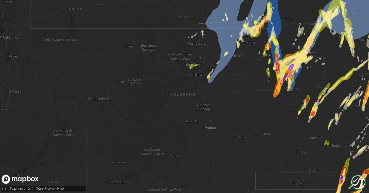
Hail Map in Colorado on May 18, 2025
Get this storm
May 18 map
$229
one time, instant access
Download today. No call, no setup
Keep the $229
Bought the map and want the full workflow? Apply the entire $229 to a subscription within 7 days. None of it is wasted.
Every map, not just this one
This buys you this map. Subscription and you get every map we run, in the markets you choose from a few cities to whole states to nationwide. Plus real-time alerts the moment a storm fires.
Contact data
Name, contact info, occupancy, even credit band for addresses in the footprint. You go from where it hit to who to call.
Become the source they trust
Unlimited branding weather history reports on demand. You already have the documented answer ready for the property owner, and you are the one who showed up with it.
Property data and RoofTrace estimates
Pull up any address you have got, its value and the exact code rules for that jurisdiction, straight from One Click Code. Then RoofTrace estimates the squares, pitch, and roof value, priced the way you price.
Storm reports in Colorado
Colorado
| Date | Description |
|---|---|
| 05/18/20256:53 PM CDT | Asos station kitr burlington co airport. |
| 05/18/20256:03 PM CDT | A local report indicates 70 MPH wind near 3 ENE Marks Butte |
| 05/18/20255:53 PM CDT | A local report indicates 63 MPH wind near 4 W Fairfield |
| 05/18/20255:38 PM CDT | Half inch to one hail hail covering the ground. |
| 05/18/20255:17 PM CDT | Social media report of quarter sized hail. |
| 05/18/20255:15 PM CDT | Storm chaser reported hen egg sized hail ~11 miles nne of burlington at approximately 4:15 pm mdt |
| 05/18/20255:15 PM CDT | Pws-kcowray7. |
| 05/18/20255:08 PM CDT | Observer reported hail ranging from nickel to golf ball in size. |
| 05/18/20255:05 PM CDT | Delayed entry. Social media report with picture of a tornado north of kirk. Potential landspout. |
| 05/18/20255:04 PM CDT | Spotter reported quarter sized hail 7 miles se of wray at approximately 4:05 pm mdt |
| 05/18/20254:55 PM CDT | Awos station k1ow 2 nw pawnee buttes. |
| 05/18/20254:51 PM CDT | Social media report with video of hail quarter to half dollar in size. |
| 05/18/20254:51 PM CDT | Social media report with video of hail quarter to half dollar in size. |
| 05/18/20254:40 PM CDT | Social media report of hail up to golf ball in size with pictures. |
| 05/18/20254:36 PM CDT | A local report indicates 60 MPH wind near 4 NW Pawnee Buttes |
| 05/18/20254:32 PM CDT | Report from mping: half dollar |
| 05/18/20254:32 PM CDT | Report from mping: half dollar |
| 05/18/20254:16 PM CDT | Picture of 1 inch hail on x. |
| 05/18/20253:51 PM CDT | A local report indicates 58 MPH wind near 6 SW Log Lane Village |
| 05/18/20253:46 PM CDT | A local report indicates 66 MPH wind near 4 SSW Orchard |
| 05/18/20252:56 PM CDT | A local report indicates 66 MPH wind near 5 NNE Bennett |
| 05/18/20252:43 PM CDT | Tornado on ground 1:43pm to 1:58pm |
| 05/18/20252:43 PM CDT | Tornado on ground with debris being lofted. |
| 05/18/20252:37 PM CDT | Tornado on ground. |
| 05/18/20252:28 PM CDT | Tornado on ground from 1:28pm to 1:34pm |
| 05/18/20252:28 PM CDT | Tornado on ground. |
| 05/18/20252:28 PM CDT | Tornado on ground from 1:28pm to 1:34pm. |
| 05/18/20252:25 PM CDT | Report from mping: ping pong ball |
| 05/18/20252:23 PM CDT | A local report indicates 70 MPH wind near 7 SSE Watkins |
| 05/18/20252:11 PM CDT | Report from mping: half dollar |
| 05/18/20252:08 PM CDT | Corrects previous tornado report from 5 se arapahoe park. Tornado on ground from 1:08pm until 1:17pm |
| 05/18/20252:08 PM CDT | Tornado on ground from 1:08pm until 1:17pm. |
| 05/18/20252:08 PM CDT | Tornado on ground from 1:08pm until 1:17pm |
| 05/17/20257:12 PM CDT | Relayed report of hail up to half dollar in size. Time estimated from radar. |
| 05/17/20257:09 PM CDT | Report of quarter sized hail in wray. |
All States Impacted by Hail Map on May 18, 2025
Cities Impacted by Hail Map on May 18, 2025
- Northport, AL
- Coker, AL
- Echola, AL
- Elrod, AL
- Gordo, AL
- Buhl, AL
- Adger, AL
- Brookwood, AL
- Tuscaloosa, AL
- Cottondale, AL
- Dolomite, AL
- Birmingham, AL
- Bessemer, AL
- Pleasant Grove, AL
- Woodstock, AL
- West Blocton, AL
- Helena, AL
- Brierfield, AL
- McCalla, AL
- Vance, AL
- Alpine, AL
- Munford, AL
- Ashland, AL
- Sylacauga, AL
- Delta, AL
- Lincoln, AL
- Oxford, AL
- Eastaboga, AL
- Talladega, AL
- Lineville, AL
- Harpersville, AL
- Childersburg, AL
- Sterrett, AL
- Vincent, AL
- Columbiana, AL
- Wilsonville, AL
- Cropwell, AL
- Cabot, AR
- Lonoke, AR
- Daviston, AL
- Cragford, AL
- Wadley, AL
- Goodwater, AL
- Alexander City, AL
- Carlisle, AR
- Hazen, AR
- Roanoke, AL
- Lafayette, AL
- Stuttgart, AR
- Millerville, AL
- Camp Hill, AL
- De Valls Bluff, AR
- Roe, AR
- Clarendon, AR
- Five Points, AL
- Holly Grove, AR
- Brinkley, AR
- Lanett, AL
- Lyon, MS
- Mellwood, AR
- Clarksdale, MS
- Crumrod, AR
- Elaine, AR
- Pryor, OK
- Adair, OK
- Tuskegee, AL
- Marks, MS
- Alligator, MS
- Hatchechubbee, AL
- Union Springs, AL
- Duncan, MS
- Tutwiler, MS
- Vance, MS
- Charleston, MS
- Lambert, MS
- Seale, AL
- Fort Mitchell, AL
- Cascilla, MS
- Holcomb, MS
- Enid, MS
- Wedowee, AL
- Franklin, GA
- Hogansville, GA
- Lagrange, GA
- Molena, GA
- Greenville, GA
- Concord, GA
- Gay, GA
- Woodbury, GA
- Warm Springs, GA
- Waverly Hall, GA
- Manchester, GA
- West Point, GA
- Thomaston, GA
- Hamilton, GA
- Pine Mountain, GA
- Pine Mountain Valley, GA
- Woodland, GA
- Shiloh, GA
- Talbotton, GA
- Meansville, GA
- Yatesville, GA
- The Rock, GA
- Roberta, GA
- Knoxville, GA
- Culloden, GA
- Lizella, GA
- Butler, GA
- Musella, GA
- Fort Valley, GA
- Junction City, GA
- Reynolds, GA
- Byron, GA
- Scobey, MS
- Grenada, MS
- Coffeeville, MS
- Tillatoba, MS
- Macon, GA
- Bonaire, GA
- Warner Robins, GA
- Centerville, GA
- Kathleen, GA
- Spavinaw, OK
- Salina, OK
- West Point, MS
- Prairie, MS
- Porter, OK
- Wagoner, OK
- Aberdeen, MS
- Chouteau, OK
- Vian, OK
- Locust Grove, OK
- Tahlequah, OK
- Hulbert, OK
- Bunch, OK
- Sallisaw, OK
- Peggs, OK
- Cleveland, OK
- Hominy, OK
- Pawnee, OK
- Stilwell, OK
- Rose, OK
- Colcord, OK
- Muldrow, OK
- Dadeville, AL
- Junction, TX
- Eucha, OK
- Tulsa, OK
- Sapulpa, OK
- Jay, OK
- Lincoln, AR
- Summers, AR
- Uniontown, AR
- Skiatook, OK
- Westville, OK
- Harper, TX
- Sperry, OK
- Collinsville, OK
- Cedarville, AR
- Rudy, AR
- Van Buren, AR
- Chester, AR
- Hoboken, GA
- Nahunta, GA
- Owasso, OK
- Mountainburg, AR
- Catoosa, OK
- Ramona, OK
- Vera, OK
- Barnsdall, OK
- Claremore, OK
- Huntsville, AL
- Sulphur Springs, AR
- Bella Vista, AR
- Noel, MO
- Inola, OK
- Burnet, TX
- Gravette, AR
- Talala, OK
- Pineville, MO
- Newcastle, WY
- Rock River, WY
- Bertram, TX
- Lampasas, TX
- Strang, OK
- Parker, CO
- Aurora, CO
- Watkins, CO
- Killeen, TX
- Oologah, OK
- Vinita, OK
- Chelsea, OK
- Big Cabin, OK
- Conway Springs, KS
- Garrett, WY
- Bennett, CO
- Milton, KS
- Viola, KS
- Goddard, KS
- Cheney, KS
- Garden Plain, KS
- Livermore, CO
- Huntsville, AR
- Colwich, KS
- Andale, KS
- Maize, KS
- Valley Center, KS
- Sedgwick, KS
- Bosler, WY
- Clearwater, KS
- Wichita, KS
- Roggen, CO
- Longmont, CO
- Laporte, CO
- Wellington, CO
- Thorsby, AL
- Maplesville, AL
- Clanton, AL
- Kansas, OK
- Twin Oaks, OK
- Snyder, CO
- Mount Hope, KS
- Maysville, AR
- Oaks, OK
- Watts, OK
- Siloam Springs, AR
- Gentry, AR
- Stoneham, CO
- Merino, CO
- Carr, CO
- Golden, CO
- Wesley, AR
- Haven, KS
- Burrton, KS
- Wiggins, CO
- Otis, CO
- Decatur, AR
- Bentonville, AR
- Sedan, KS
- Delaware, OK
- Nowata, OK
- Derby, KS
- Atlanta, KS
- Burden, KS
- Copan, OK
- Rose Hill, KS
- Douglass, KS
- Wann, OK
- Dewey, OK
- Fayetteville, AR
- Springdale, AR
- Eldorado Springs, CO
- Boulder, CO
- Weldona, CO
- Sterling, CO
- Abilene, TX
- Halstead, KS
- Albany, TX
- Lueders, TX
- Dyess Afb, TX
- Tye, TX
- Lowell, AR
- Burlington, CO
- Rogers, AR
- Louisville, CO
- Lafayette, CO
- Fort Morgan, CO
- Orchard, CO
- New Raymer, CO
- Briggsdale, CO
- Grover, CO
- Winters, TX
- Otter, MT
- Padroni, CO
- Hesston, KS
- Centerton, AR
- Wheatland, WY
- Prairie Grove, AR
- Ovalo, TX
- Newton, KS
- Moundridge, KS
- Berryville, AR
- Eureka Springs, AR
- Hindsville, AR
- Canadian, TX
- Cedar Vale, KS
- Lawn, TX
- Elkins, AR
- Cave Springs, AR
- Clyde, TX
- Peetz, CO
- Sidney, NE
- Erie, CO
- Tuscola, TX
- Goodland, KS
- Lipscomb, TX
- Follett, TX
- Higgins, TX
- Leoti, KS
- Idalia, CO
- Box Elder, SD
- Bee Branch, AR
- Center Ridge, AR
- Damascus, AR
- Throckmorton, TX
- Hays, KS
- Pfeifer, KS
- Potter, NE
- Dix, NE
- Victoria, KS
- Kanorado, KS
- Wray, CO
- Saint Francis, KS
- Chase, KS
- Raymond, KS
- Laverne, OK
- Pine Bluffs, WY
- Decker, MT
- Green Forest, AR
- Lyons, KS
- Gorham, KS
- Paradise, KS
- Iliff, CO
- Crook, CO
- Shattuck, OK
- Stratton, CO
- Witter, AR
- Arnett, OK
- Bushton, KS
- Lorraine, KS
- Holyrood, KS
- Bird City, KS
- Edson, KS
- Kirk, CO
- Yuma, CO
- Joes, CO
- Ellsworth, KS
- Eckley, CO
- Wilson, KS
- Birney, MT
- Russell, KS
- Winona, KS
- West Fork, AR
- Natoma, KS
- Plainville, KS
- Marienthal, KS
- Scott City, KS
- Kechi, KS
- Quitman, AR
- Bushnell, NE
- Dorrance, KS
- Bunker Hill, KS
- Ellinwood, KS
- Farmington, AR
- Baird, TX
- Newcastle, TX
- Sylvan Grove, KS
- Geneseo, KS
- Holyoke, CO
- Alton, KS
- Gaylord, KS
- Osborne, KS
- Burns, WY
- Hillsdale, WY
- Carpenter, WY
- Hereford, CO
- Cheyenne, WY
- Nunn, CO
- Albin, WY
- Meriden, WY
- Harrisburg, NE
- Kimball, NE
- Gurley, NE
- Lagrange, WY
- Waldo, KS
- Oakley, KS
- Lodgepole, NE
- Ten Sleep, WY
- Jasper, AR
- Vendor, AR
- Neodesha, KS
- Lucas, KS
- Luray, KS
- Little River, KS
- Parthenon, AR
- Haigler, NE
- Severy, KS
- Kingston, AR
- Monument, KS
- Smith Center, KS
- Cedar, KS
- Athol, KS
- Haxtun, CO
- Paoli, CO
- Amherst, CO
- Sedgwick, CO
- Ovid, CO
- Vernon, CO
- Rosston, OK
- Buffalo, OK
- Ashland, KS
- Whitewater, KS
- Dalton, NE
- Cimarron, KS
- Peabody, KS
- Walton, KS
- Eureka, KS
- Broomfield, CO
- Lincoln, KS
- Breckenridge, TX
- Portis, KS
- Deer, AR
- Kanopolis, KS
- Windom, KS
- Toronto, KS
- Altoona, KS
- El Dorado, KS
- Moran, TX
- Gate, OK
- Ingalls, KS
- Durham, OK
- Dighton, KS
- Minneola, KS
- Alliance, NE
- Hemingford, NE
- Mitchell, NE
- Torrington, WY
- Yoder, WY
- Gering, NE
- Morrill, NE
- Lyman, NE
- Hawk Springs, WY
- Harrison, NE
- Minatare, NE
- Mcgrew, NE
- Bayard, NE
- Melbeta, NE
- Scottsbluff, NE
- Bridgeport, NE
- Angora, NE
- Broadwater, NE
- Lisco, NE
- Sharon, OK
- Burns, KS
- Graham, TX
- Marquette, KS
- Marion, KS
- Hillsboro, KS
- Hunter, KS
- Tipton, KS
- Beloit, KS
- Glade, KS
- Kirwin, KS
- Cassoday, KS
- Julesburg, CO
- Cisco, TX
- Brookville, KS
- Falun, KS
- Parks, NE
- Benkelman, NE
- Max, NE
- Stratton, NE
- Kensington, KS
- Riverton, NE
- Franklin, NE
- Bloomington, NE
- McDonald, KS
- Lincolnville, KS
- Randall, KS
- Tampa, KS
- Ramona, KS
- Lost Springs, KS
- Madison, KS
- Hamilton, KS
- Downs, KS
- Glen Elder, KS
- Cawker City, KS
- Bucklin, KS
- Mankato, KS
- Burr Oak, KS
- Virgil, KS
- Grinnell, KS
- Barnard, KS
- Lindsborg, KS
- Robert Lee, TX
- Salina, KS
- Woodward, OK
- Big Springs, NE
- Chappell, NE
- Oshkosh, NE
- Fargo, OK
- Hope, KS
- Herington, KS
- Woodbine, KS
- Chapman, KS
- Junction City, KS
- Enterprise, KS
- Ranger, TX
- Guide Rock, NE
- Republican City, NE
- Upland, NE
- Courtland, KS
- Orleans, NE
- Jewell, KS
- Esbon, KS
- Eastland, TX
- Beeler, KS
- Hildreth, NE
- Oxford, NE
- Alma, NE
- Ness City, KS
- Assaria, KS
- New Cambria, KS
- Colby, KS
- Caddo, TX
- Marsland, NE
- Lewellen, NE
- Wauneta, NE
- Palisade, NE
- Imperial, NE
- Bertrand, NE
- Atlanta, NE
- Holdrege, NE
- Utica, KS
- Loomis, NE
- Offerle, KS
- Hoxie, KS
- Simpson, KS
- Jacksboro, TX
- Kinsley, KS
- Lebanon, KS
- Burdick, KS
- Solomon, KS
- Fort Supply, OK
- Smithfield, NE
- Lexington, NE
- Overton, NE
- Eddyville, NE
- Sumner, NE
- Elwood, NE
- Mooreland, OK
- Strawn, TX
- Arnold, KS
- Perrin, TX
- White City, KS
- Sterling City, TX
- Ellsworth, NE
- Enders, NE
- Minden, NE
- Eustis, NE
- Graford, TX
- Madrid, NE
- Olpe, KS
- Emporia, KS
- Grainfield, KS
- Ransom, KS
- Hayes Center, NE
- Collyer, KS
- Wakeeney, KS
- Cozad, NE
- Gordon, TX
- Kearney, NE
- Heartwell, NE
- Gibbon, NE
- Kenesaw, NE
- Wood River, NE
- Shelton, NE
- Abilene, KS
- Elsie, NE
- Garfield, KS
- Lewis, KS
- Jamestown, KS
- Concordia, KS
- Paradise, TX
- Bridgeport, TX
- Ogallah, KS
- Council Grove, KS
- Palo Pinto, TX
- Lakeside, NE
- Bingham, NE
- Oconto, NE
- Callaway, NE
- Broken Bow, NE
- Merna, NE
- Anselmo, NE
- Longford, KS
- Wakefield, KS
- Larned, KS
- Brady, NE
- Gothenburg, NE
- Ellis, KS
- Greenbrier, AR
- Woodston, KS
- Selden, KS
- Guy, AR
- Scandia, KS
- Norway, KS
- Santo, TX
- Decatur, TX
- Mingus, TX
- Mineral Wells, TX
- Maxwell, NE
- Stapleton, NE
- Ravenna, NE
- Cairo, NE
- Freedom, OK
- Paxton, NE
- Wallace, NE
- Morland, KS
- Millsap, TX
- Clay Center, KS
- Dickens, NE
- Judsonia, AR
- Searcy, AR
- Palco, KS
- Lebo, KS
- Bluff Dale, TX
- Stephenville, TX
- Lipan, TX
- Tryon, NE
- Arnold, NE
- Dunning, NE
- Bronte, TX
- Boelus, NE
- Dannebrog, NE
- Grand Island, NE
- Wellfleet, NE
- North Platte, NE
- Weatherford, TX
- Belleville, KS
- Agenda, KS
- Cuba, KS
- McCrory, AR
- Augusta, AR
- Hill City, KS
- Lenora, KS
- Wynne, AR
- Colt, AR
- Cotton Plant, AR
- Riley, KS
- Milford, KS
- Leonardville, KS
- Sanger, TX
- Pawnee Rock, KS
- Justin, TX
- Krum, TX
- Chico, TX
- Rose Bud, AR
- Romance, AR
- Alva, OK
- Coldwater, KS
- Penokee, KS
- Norton, TX
- Bald Knob, AR
- Palestine, AR
- Hunter, AR
- McRae, AR
- Beebe, AR
- Gainesville, TX
- Kensett, AR
- Garner, AR
- Higginson, AR
- Hershey, NE
- Lake City, KS
- Narka, KS
- Wheatley, AR
- Rhome, TX
- Griffithville, AR
- Stockton, KS
- Spearville, KS
- Almena, KS
- Granbury, TX
- Tolar, TX
- Superior, NE
- Westphalia, KS
- Great Bend, KS
- Waynoka, OK
- Trenton, NE
- Mullinville, KS
- Hubbell, NE
- Reynolds, NE
- Lawrence, NE
- Nelson, NE
- Ponder, TX
- Argyle, TX
- Denton, TX
- Munden, KS
- Prairie View, KS
- Mahaska, KS
- Fairbury, NE
- Hoisington, KS
- Randolph, KS
- Forrest City, AR
- Humboldt, KS
- La Harpe, KS
- Sutherland, NE
- Oak, NE
- Heth, AR
- Proctor, AR
- Marianna, AR
- Widener, AR
- Long Island, KS
- Phillipsburg, KS
- Chanute, KS
- Claflin, KS
- Aledo, TX
- Haviland, KS
- Memphis, TN
- Atwood, KS
- West Memphis, AR
- Edgar, NE
- Iola, KS
- Talpa, TX
- Greensburg, KS
- Frankfort, KS
- Hughes, AR
- Brickeys, AR
- Culbertson, NE
- Elizabeth, CO
- Strasburg, CO
- Byers, CO
- Aubrey, TX
- Prosper, TX
- Shickley, NE
- Frisco, TX
- Robinsonville, MS
- Davenport, NE
- Coleman, TX
- Novice, TX
- Plymouth, NE
- Jansen, NE
- Olmitz, KS
- Belpre, KS
- Agra, KS
- Daykin, NE
- Log Lane Village, CO
- Kersey, CO
- Albert, KS
- Little Elm, TX
- Keenesburg, CO
- Hudson, CO
- Mckinney, TX
- Celina, TX
- Ong, NE
- Naponee, NE
- Lake Cormorant, MS
- Erie, KS
- Saint Paul, KS
- Hernando, MS
- Vermillion, KS
- Geneva, NE
- Coldwater, MS
- Tunica, MS
- Walls, MS
- McCook, NE
- Nesbit, MS
- Burkett, TX
- Brownwood, TX
- Cross Plains, TX
- Pratt, KS
- Stark, KS
- Oberlin, KS
- May, TX
- Iuka, KS
- Byhalia, MS
- Holly Springs, MS
- Byers, KS
- Turon, KS
- Stafford, KS
- Cresson, TX
- St John, KS
- Alvord, TX
- Waterford, MS
- Danbury, NE
- Inavale, NE
- Senatobia, MS
- Glasco, KS
- Potts Camp, MS
- Hepler, KS
- Uniontown, KS
- Red Cloud, NE
- Hickory Flat, MS
- Purdum, NE
- Brewster, NE
- Bassett, NE
- Ansley, NE
- Taylor, NE
- Westerville, NE
- Comstock, NE
- Ainsworth, NE
- Sargent, NE
- Elyria, NE
- Burwell, NE
- Ord, NE
- Sylvia, KS
- Plevna, KS
- Ponca, AR
- Moran, KS
- Dennis, MS
- Belmont, MS
- New Site, MS
- Golden, MS
- Redfield, KS
- Delphos, KS
- Amelia, NE
- Willow Island, NE
- Elm Creek, NE
- Mason City, NE
- Miller, NE
- Amherst, NE
- Loup City, NE
- Pleasanton, NE
- Litchfield, NE
- Riverdale, NE
- Arcadia, NE
- Hazard, NE
- Ashton, NE
- North Loup, NE
- Rockville, NE
- Farwell, NE
- Savonburg, KS
- Tishomingo, MS
- Blue Mountain, MS
- Haddam, KS
- Myrtle, MS
- New Albany, MS
- Abbyville, KS
- Lockwood, MO
- Iuka, MS
- Bronson, KS
- Jerico Springs, MO
- Kincaid, KS
- Stockton, MO
- Arcola, MO
- Ripley, MS
- Nickerson, KS
- Saint Paul, NE
- Bartlett, NE
- Greeley, NE
- Ericson, NE
- Ewing, NE
- Atkinson, NE
- Scotia, NE
- Elba, NE
- Wolbach, NE
- Chambers, NE
- Palmer, NE
- Saint Libory, NE
- Sterling, KS
- Crete, NE
- Cherokee, AL
- Richards, MO
- Booneville, MS
- Dumas, MS
- Spalding, NE
- Cedar Rapids, NE
- Primrose, NE
- Logan, KS
- Fort Scott, KS
- Allen, KS
- Blue Springs, NE
- Wymore, NE
- Alma, KS
- Beatrice, NE
- Odell, NE
- Mcpherson, KS
- Hodges, AL
- Minneapolis, KS
- Green, KS
- Eskridge, KS
- Filley, NE
- Red Bay, AL
- Fullerton, NE
- Belgrade, NE
- Topeka, KS
- Maple Hill, KS
- Harveyville, KS
- Russellville, AL
- Adams, NE
- Crab Orchard, NE
- Auburn, KS
- Virginia, NE
- Tecumseh, NE
- Sterling, NE
- Lewiston, NE
- Madison, AL
- Steinauer, NE
- Silver Lake, KS
- Elk Creek, NE
- Meriden, KS
- Grantville, KS
- Oskaloosa, KS
- Ozawkie, KS
- Maryneal, TX
- Blackwell, TX
- Roscoe, TX
- Moulton, AL
- Excelsior Springs, MO
- Orrick, MO
- Hartselle, AL
- Missouri City, MO
- Rayville, MO
- Formoso, KS
- Clyde, KS
- Sutton, NE
- Grafton, NE


