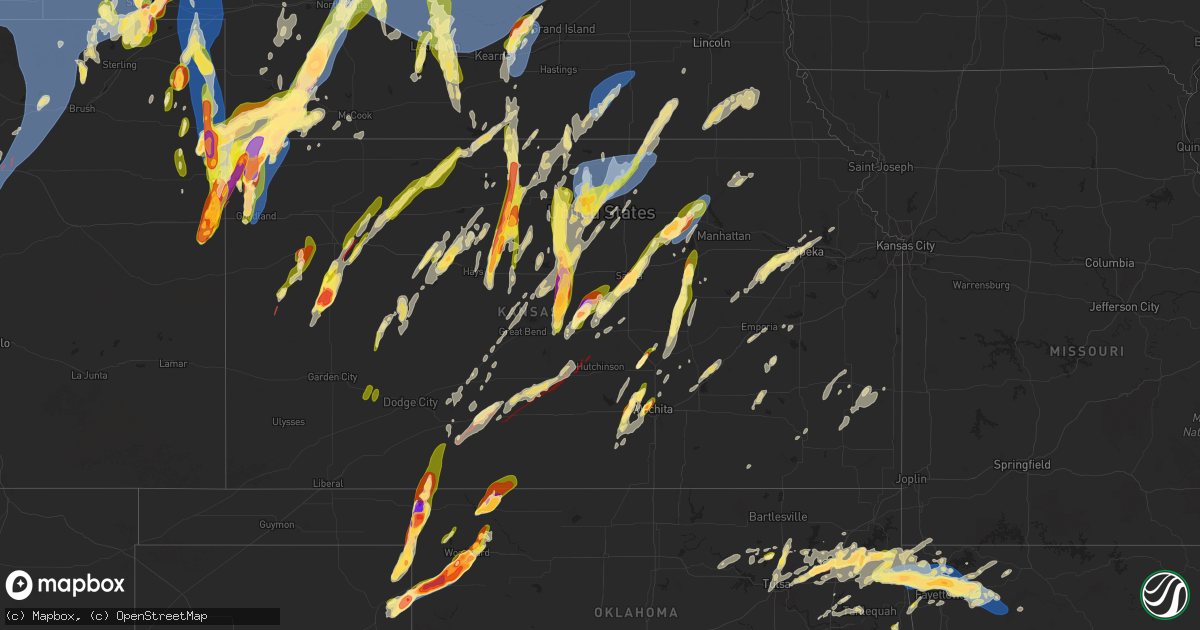
Hail Map in Kansas on May 18, 2025
Get this storm
May 18 map
$229
one time, instant access
Download today. No call, no setup
Keep the $229
Bought the map and want the full workflow? Apply the entire $229 to a subscription within 7 days. None of it is wasted.
Every map, not just this one
This buys you this map. Subscription and you get every map we run, in the markets you choose from a few cities to whole states to nationwide. Plus real-time alerts the moment a storm fires.
Contact data
Name, contact info, occupancy, even credit band for addresses in the footprint. You go from where it hit to who to call.
Become the source they trust
Unlimited branding weather history reports on demand. You already have the documented answer ready for the property owner, and you are the one who showed up with it.
Property data and RoofTrace estimates
Pull up any address you have got, its value and the exact code rules for that jurisdiction, straight from One Click Code. Then RoofTrace estimates the squares, pitch, and roof value, priced the way you price.
Storm reports in Kansas
Kansas
| Date | Description |
|---|---|
| 05/18/20256:55 PM CDT | Report from the emergency manager that the town of grinnell was hit by a tornado. |
| 05/18/20256:55 PM CDT | Tds observed on radar. |
| 05/18/20256:55 PM CDT | A local report indicates 1.00 inch wind near 3 SW Junction City |
| 05/18/20256:52 PM CDT | A local report indicates 1.50 inch wind near Beloit |
| 05/18/20256:51 PM CDT | Report on social media of ping pong ball size hail in beloit. |
| 05/18/20256:51 PM CDT | A local report indicates 1.50 inch wind near 2 S Salina |
| 05/18/20256:45 PM CDT | Time and location estimated from radar. |
| 05/18/20256:43 PM CDT | Received via mping. |
| 05/18/20256:43 PM CDT | A local report indicates 1.50 inch wind near 4 NNW Woodbine |
| 05/18/20256:42 PM CDT | A local report indicates 1.00 inch wind near 1 SSW Woodbine |
| 05/18/20256:35 PM CDT | Storm spotter network report of one inch hail. |
| 05/18/20256:35 PM CDT | Storm chaser video of tornado on the ground near gove... Ks. |
| 05/18/20256:33 PM CDT | A local report indicates 1.00 inch wind near Herington |
| 05/18/20256:31 PM CDT | A local report indicates 1.25 inch wind near 12 N Bird City |
| 05/18/20256:30 PM CDT | Delayed report from last night via social media. Corrected for hail size. |
| 05/18/20256:22 PM CDT | A local report indicates 1.00 inch wind near 6 WNW Lost Springs |
| 05/18/20256:19 PM CDT | 3350_(awn |
| 05/18/20256:19 PM CDT | 3350_ |
| 05/18/20256:16 PM CDT | Social media report |
| 05/18/20256:15 PM CDT | Report of 1 inch hail north of bird city. |
| 05/18/20256:10 PM CDT | Emergency manager confirmed tornado. |
| 05/18/20256:08 PM CDT | Approximately 15 rail cars blown over and power lines damaged. May be from a possible tornado. |
| 05/18/20256:02 PM CDT | A local report indicates 2.00 inch wind near 3 SSE Saint Francis |
| 05/18/20256:01 PM CDT | Mping report. |
| 05/18/20256:00 PM CDT | Delayed entry. Social media report with picture of 2 inch hail on cr 15. |
| 05/18/20255:57 PM CDT | A local report indicates 1.25 inch wind near 8 WNW Marquette |
| 05/18/20255:55 PM CDT | Report from mping: golf ball |
| 05/18/20255:52 PM CDT | A local report indicates 1.00 inch wind near 3 E Ingalls |
| 05/18/20255:50 PM CDT | A local report indicates 1.25 inch wind near 5 N Sylvan Grove |
| 05/18/20255:50 PM CDT | Delayed entry. Social media report with picture of golf ball sized hail. |
| 05/18/20255:49 PM CDT | Tds noted on radar. |
| 05/18/20255:45 PM CDT | Mesonet station up840 9.0 w winona |
| 05/18/20255:45 PM CDT | Up840. |
| 05/18/20255:44 PM CDT | This report included video of the tornado. |
| 05/18/20255:41 PM CDT | Spotter reports hail up to golf ball in northern portion of saint francis. |
| 05/18/20255:39 PM CDT | A local report indicates 1.75 inch wind near Geneseo |
| 05/18/20255:38 PM CDT | Spotter reports quarter sized hail in alton. |
| 05/18/20255:38 PM CDT | A local report indicates 1.50 inch wind near 1 W Geneseo |
| 05/18/20255:38 PM CDT | Report from mping: ping pong ball |
| 05/18/20255:36 PM CDT | Report from mping: golf ball |
| 05/18/20255:35 PM CDT | Report from mping: half dollar |
| 05/18/20255:35 PM CDT | Report from mping: half dollar |
| 05/18/20255:35 PM CDT | Off duty nws employee reports hailstones still on the ground up to 2 inches in size. Time estimated from radar. |
| 05/18/20255:35 PM CDT | A local report indicates 2.00 inch wind near 1 S Wheeler |
| 05/18/20255:34 PM CDT | Photo sent in by emergency manager... Public report. |
| 05/18/20255:33 PM CDT | Report from mping: quarter |
| 05/18/20255:33 PM CDT | Report from mping: quarter |
| 05/18/20255:31 PM CDT | A local report indicates 1.75 inch wind near 5 WSW Scott State Lake |
| 05/18/20255:28 PM CDT | Spotter reports quarter size hail south of alton. |
| 05/18/20255:27 PM CDT | Report from mping: quarter |
| 05/18/20255:25 PM CDT | Report of damage to a homestead. Time estimated from radar. |
| 05/18/20255:19 PM CDT | A local report indicates 2.00 inch wind near Holyrood |
| 05/18/20255:16 PM CDT | Off duty nws employee reported a tornado 7 miles north of kanorado |
| 05/18/20255:15 PM CDT | A local report indicates 1.00 inch wind near Bushton |
| 05/18/20255:15 PM CDT | Em relayed damage to a building on road j near road 6 & 7. |
| 05/18/20255:06 PM CDT | Asos station kgld goodland measured a 60 mph |
| 05/18/20254:58 PM CDT | Asos station kgld goodland measured a 58 mph wind gust at 3:58 pm mdt |
| 05/18/20254:58 PM CDT | Asos station kgld goodla |
| 05/18/20254:55 PM CDT | Delayed report. Report of quarter sized hail. Time estimated from radar. |
| 05/18/20254:52 PM CDT | A local report indicates 1.25 inch wind near 1 SSE Ruleton |
| 05/18/20254:26 PM CDT | A local report indicates 1.50 inch wind near 1 NW Hesston |
| 05/18/20253:29 PM CDT | Near 13th and west... Courtesy of kake tv. |
| 05/18/20253:28 PM CDT | Near 9th and zoo boulevard. |
| 05/18/20253:25 PM CDT | Near kellogg and ridge. |
| 05/18/20253:24 PM CDT | Half dollar size hail at nws office. |
| 05/18/20253:15 PM CDT | A local report indicates 1.50 inch wind near Colwich |
| 05/18/20252:59 PM CDT | A local report indicates 1.25 inch wind near 2 E Garden Plain |
| 05/17/202511:50 PM CDT | Home destroyed and power lines down. |
| 05/17/202511:42 PM CDT | Off duty nws employee reports a very large tornado. Radar also shows a very large debris signature. |
| 05/17/202511:40 PM CDT | A local report indicates a tornado near Neola |
| 05/17/202511:23 PM CDT | Storm chaser photo of large tornado along with debris signature on radar. |
| 05/17/202511:05 PM CDT | Trees shredded and powerlines and poles snaped. Tornado damage possible. |
| 05/17/202510:55 PM CDT | Several powerlines down at this location. Possible tornado. |
| 05/17/20259:53 PM CDT | Report included pictures. |
| 05/17/20259:38 PM CDT | A local report indicates a tornado near 11 SE Mullinville |
| 05/17/20258:11 PM CDT | A local report indicates 1.75 inch wind near 7 W Wakefield |
| 05/17/20258:11 PM CDT | 1.5 to 2.5 inch diameter limbs down. |
| 05/17/20258:07 PM CDT | A local report indicates 1.00 inch wind near 7 S New Almelo |
| 05/17/20257:57 PM CDT | A local report indicates 1.75 inch wind near 5 N Ellis |
| 05/17/20257:55 PM CDT | Asos station kcnk concordia. |
| 05/17/20257:50 PM CDT | Videos of the tornado from the broadcast media. |
| 05/17/20257:47 PM CDT | A local report indicates 1.00 inch wind near Ogallah |
| 05/17/20257:34 PM CDT | Dime to quarter size hail. |
| 05/17/20257:32 PM CDT | Relayed report of quarter sized hail. |
| 05/17/20257:31 PM CDT | Live streaming video of tornado was on kake-tv. |
| 05/17/20257:30 PM CDT | Report of half dollar sized hail in hoxie. |
| 05/17/20257:07 PM CDT | Chaser report of one inch hail on interstate 70. |
| 05/17/20257:06 PM CDT | Possible tornado. Delayed report of powerlines down for a mile along w road 90 s. Time estimated. |
| 05/17/20257:05 PM CDT | Possible tornado. Delayed report of damage to a building along road s 40w. Time estimated. |
| 05/17/20257:05 PM CDT | Report on social media of ping pong ball sized hail in beloit. |
| 05/17/20257:02 PM CDT | Multiple reports of tornado just east of grinnell. One report of it roping out. |
All States Impacted by Hail Map on May 18, 2025
Cities Impacted by Hail Map on May 18, 2025
- Northport, AL
- Coker, AL
- Echola, AL
- Elrod, AL
- Gordo, AL
- Buhl, AL
- Adger, AL
- Brookwood, AL
- Tuscaloosa, AL
- Cottondale, AL
- Dolomite, AL
- Birmingham, AL
- Bessemer, AL
- Pleasant Grove, AL
- Woodstock, AL
- West Blocton, AL
- Helena, AL
- Brierfield, AL
- McCalla, AL
- Vance, AL
- Alpine, AL
- Munford, AL
- Ashland, AL
- Sylacauga, AL
- Delta, AL
- Lincoln, AL
- Oxford, AL
- Eastaboga, AL
- Talladega, AL
- Lineville, AL
- Harpersville, AL
- Childersburg, AL
- Sterrett, AL
- Vincent, AL
- Columbiana, AL
- Wilsonville, AL
- Cropwell, AL
- Cabot, AR
- Lonoke, AR
- Daviston, AL
- Cragford, AL
- Wadley, AL
- Goodwater, AL
- Alexander City, AL
- Carlisle, AR
- Hazen, AR
- Roanoke, AL
- Lafayette, AL
- Stuttgart, AR
- Millerville, AL
- Camp Hill, AL
- De Valls Bluff, AR
- Roe, AR
- Clarendon, AR
- Five Points, AL
- Holly Grove, AR
- Brinkley, AR
- Lanett, AL
- Lyon, MS
- Mellwood, AR
- Clarksdale, MS
- Crumrod, AR
- Elaine, AR
- Pryor, OK
- Adair, OK
- Tuskegee, AL
- Marks, MS
- Alligator, MS
- Hatchechubbee, AL
- Union Springs, AL
- Duncan, MS
- Tutwiler, MS
- Vance, MS
- Charleston, MS
- Lambert, MS
- Seale, AL
- Fort Mitchell, AL
- Cascilla, MS
- Holcomb, MS
- Enid, MS
- Wedowee, AL
- Franklin, GA
- Hogansville, GA
- Lagrange, GA
- Molena, GA
- Greenville, GA
- Concord, GA
- Gay, GA
- Woodbury, GA
- Warm Springs, GA
- Waverly Hall, GA
- Manchester, GA
- West Point, GA
- Thomaston, GA
- Hamilton, GA
- Pine Mountain, GA
- Pine Mountain Valley, GA
- Woodland, GA
- Shiloh, GA
- Talbotton, GA
- Meansville, GA
- Yatesville, GA
- The Rock, GA
- Roberta, GA
- Knoxville, GA
- Culloden, GA
- Lizella, GA
- Butler, GA
- Musella, GA
- Fort Valley, GA
- Junction City, GA
- Reynolds, GA
- Byron, GA
- Scobey, MS
- Grenada, MS
- Coffeeville, MS
- Tillatoba, MS
- Macon, GA
- Bonaire, GA
- Warner Robins, GA
- Centerville, GA
- Kathleen, GA
- Spavinaw, OK
- Salina, OK
- West Point, MS
- Prairie, MS
- Porter, OK
- Wagoner, OK
- Aberdeen, MS
- Chouteau, OK
- Vian, OK
- Locust Grove, OK
- Tahlequah, OK
- Hulbert, OK
- Bunch, OK
- Sallisaw, OK
- Peggs, OK
- Cleveland, OK
- Hominy, OK
- Pawnee, OK
- Stilwell, OK
- Rose, OK
- Colcord, OK
- Muldrow, OK
- Dadeville, AL
- Junction, TX
- Eucha, OK
- Tulsa, OK
- Sapulpa, OK
- Jay, OK
- Lincoln, AR
- Summers, AR
- Uniontown, AR
- Skiatook, OK
- Westville, OK
- Harper, TX
- Sperry, OK
- Collinsville, OK
- Cedarville, AR
- Rudy, AR
- Van Buren, AR
- Chester, AR
- Hoboken, GA
- Nahunta, GA
- Owasso, OK
- Mountainburg, AR
- Catoosa, OK
- Ramona, OK
- Vera, OK
- Barnsdall, OK
- Claremore, OK
- Huntsville, AL
- Sulphur Springs, AR
- Bella Vista, AR
- Noel, MO
- Inola, OK
- Burnet, TX
- Gravette, AR
- Talala, OK
- Pineville, MO
- Newcastle, WY
- Rock River, WY
- Bertram, TX
- Lampasas, TX
- Strang, OK
- Parker, CO
- Aurora, CO
- Watkins, CO
- Killeen, TX
- Oologah, OK
- Vinita, OK
- Chelsea, OK
- Big Cabin, OK
- Conway Springs, KS
- Garrett, WY
- Bennett, CO
- Milton, KS
- Viola, KS
- Goddard, KS
- Cheney, KS
- Garden Plain, KS
- Livermore, CO
- Huntsville, AR
- Colwich, KS
- Andale, KS
- Maize, KS
- Valley Center, KS
- Sedgwick, KS
- Bosler, WY
- Clearwater, KS
- Wichita, KS
- Roggen, CO
- Longmont, CO
- Laporte, CO
- Wellington, CO
- Thorsby, AL
- Maplesville, AL
- Clanton, AL
- Kansas, OK
- Twin Oaks, OK
- Snyder, CO
- Mount Hope, KS
- Maysville, AR
- Oaks, OK
- Watts, OK
- Siloam Springs, AR
- Gentry, AR
- Stoneham, CO
- Merino, CO
- Carr, CO
- Golden, CO
- Wesley, AR
- Haven, KS
- Burrton, KS
- Wiggins, CO
- Otis, CO
- Decatur, AR
- Bentonville, AR
- Sedan, KS
- Delaware, OK
- Nowata, OK
- Derby, KS
- Atlanta, KS
- Burden, KS
- Copan, OK
- Rose Hill, KS
- Douglass, KS
- Wann, OK
- Dewey, OK
- Fayetteville, AR
- Springdale, AR
- Eldorado Springs, CO
- Boulder, CO
- Weldona, CO
- Sterling, CO
- Abilene, TX
- Halstead, KS
- Albany, TX
- Lueders, TX
- Dyess Afb, TX
- Tye, TX
- Lowell, AR
- Burlington, CO
- Rogers, AR
- Louisville, CO
- Lafayette, CO
- Fort Morgan, CO
- Orchard, CO
- New Raymer, CO
- Briggsdale, CO
- Grover, CO
- Winters, TX
- Otter, MT
- Padroni, CO
- Hesston, KS
- Centerton, AR
- Wheatland, WY
- Prairie Grove, AR
- Ovalo, TX
- Newton, KS
- Moundridge, KS
- Berryville, AR
- Eureka Springs, AR
- Hindsville, AR
- Canadian, TX
- Cedar Vale, KS
- Lawn, TX
- Elkins, AR
- Cave Springs, AR
- Clyde, TX
- Peetz, CO
- Sidney, NE
- Erie, CO
- Tuscola, TX
- Goodland, KS
- Lipscomb, TX
- Follett, TX
- Higgins, TX
- Leoti, KS
- Idalia, CO
- Box Elder, SD
- Bee Branch, AR
- Center Ridge, AR
- Damascus, AR
- Throckmorton, TX
- Hays, KS
- Pfeifer, KS
- Potter, NE
- Dix, NE
- Victoria, KS
- Kanorado, KS
- Wray, CO
- Saint Francis, KS
- Chase, KS
- Raymond, KS
- Laverne, OK
- Pine Bluffs, WY
- Decker, MT
- Green Forest, AR
- Lyons, KS
- Gorham, KS
- Paradise, KS
- Iliff, CO
- Crook, CO
- Shattuck, OK
- Stratton, CO
- Witter, AR
- Arnett, OK
- Bushton, KS
- Lorraine, KS
- Holyrood, KS
- Bird City, KS
- Edson, KS
- Kirk, CO
- Yuma, CO
- Joes, CO
- Ellsworth, KS
- Eckley, CO
- Wilson, KS
- Birney, MT
- Russell, KS
- Winona, KS
- West Fork, AR
- Natoma, KS
- Plainville, KS
- Marienthal, KS
- Scott City, KS
- Kechi, KS
- Quitman, AR
- Bushnell, NE
- Dorrance, KS
- Bunker Hill, KS
- Ellinwood, KS
- Farmington, AR
- Baird, TX
- Newcastle, TX
- Sylvan Grove, KS
- Geneseo, KS
- Holyoke, CO
- Alton, KS
- Gaylord, KS
- Osborne, KS
- Burns, WY
- Hillsdale, WY
- Carpenter, WY
- Hereford, CO
- Cheyenne, WY
- Nunn, CO
- Albin, WY
- Meriden, WY
- Harrisburg, NE
- Kimball, NE
- Gurley, NE
- Lagrange, WY
- Waldo, KS
- Oakley, KS
- Lodgepole, NE
- Ten Sleep, WY
- Jasper, AR
- Vendor, AR
- Neodesha, KS
- Lucas, KS
- Luray, KS
- Little River, KS
- Parthenon, AR
- Haigler, NE
- Severy, KS
- Kingston, AR
- Monument, KS
- Smith Center, KS
- Cedar, KS
- Athol, KS
- Haxtun, CO
- Paoli, CO
- Amherst, CO
- Sedgwick, CO
- Ovid, CO
- Vernon, CO
- Rosston, OK
- Buffalo, OK
- Ashland, KS
- Whitewater, KS
- Dalton, NE
- Cimarron, KS
- Peabody, KS
- Walton, KS
- Eureka, KS
- Broomfield, CO
- Lincoln, KS
- Breckenridge, TX
- Portis, KS
- Deer, AR
- Kanopolis, KS
- Windom, KS
- Toronto, KS
- Altoona, KS
- El Dorado, KS
- Moran, TX
- Gate, OK
- Ingalls, KS
- Durham, OK
- Dighton, KS
- Minneola, KS
- Alliance, NE
- Hemingford, NE
- Mitchell, NE
- Torrington, WY
- Yoder, WY
- Gering, NE
- Morrill, NE
- Lyman, NE
- Hawk Springs, WY
- Harrison, NE
- Minatare, NE
- Mcgrew, NE
- Bayard, NE
- Melbeta, NE
- Scottsbluff, NE
- Bridgeport, NE
- Angora, NE
- Broadwater, NE
- Lisco, NE
- Sharon, OK
- Burns, KS
- Graham, TX
- Marquette, KS
- Marion, KS
- Hillsboro, KS
- Hunter, KS
- Tipton, KS
- Beloit, KS
- Glade, KS
- Kirwin, KS
- Cassoday, KS
- Julesburg, CO
- Cisco, TX
- Brookville, KS
- Falun, KS
- Parks, NE
- Benkelman, NE
- Max, NE
- Stratton, NE
- Kensington, KS
- Riverton, NE
- Franklin, NE
- Bloomington, NE
- McDonald, KS
- Lincolnville, KS
- Randall, KS
- Tampa, KS
- Ramona, KS
- Lost Springs, KS
- Madison, KS
- Hamilton, KS
- Downs, KS
- Glen Elder, KS
- Cawker City, KS
- Bucklin, KS
- Mankato, KS
- Burr Oak, KS
- Virgil, KS
- Grinnell, KS
- Barnard, KS
- Lindsborg, KS
- Robert Lee, TX
- Salina, KS
- Woodward, OK
- Big Springs, NE
- Chappell, NE
- Oshkosh, NE
- Fargo, OK
- Hope, KS
- Herington, KS
- Woodbine, KS
- Chapman, KS
- Junction City, KS
- Enterprise, KS
- Ranger, TX
- Guide Rock, NE
- Republican City, NE
- Upland, NE
- Courtland, KS
- Orleans, NE
- Jewell, KS
- Esbon, KS
- Eastland, TX
- Beeler, KS
- Hildreth, NE
- Oxford, NE
- Alma, NE
- Ness City, KS
- Assaria, KS
- New Cambria, KS
- Colby, KS
- Caddo, TX
- Marsland, NE
- Lewellen, NE
- Wauneta, NE
- Palisade, NE
- Imperial, NE
- Bertrand, NE
- Atlanta, NE
- Holdrege, NE
- Utica, KS
- Loomis, NE
- Offerle, KS
- Hoxie, KS
- Simpson, KS
- Jacksboro, TX
- Kinsley, KS
- Lebanon, KS
- Burdick, KS
- Solomon, KS
- Fort Supply, OK
- Smithfield, NE
- Lexington, NE
- Overton, NE
- Eddyville, NE
- Sumner, NE
- Elwood, NE
- Mooreland, OK
- Strawn, TX
- Arnold, KS
- Perrin, TX
- White City, KS
- Sterling City, TX
- Ellsworth, NE
- Enders, NE
- Minden, NE
- Eustis, NE
- Graford, TX
- Madrid, NE
- Olpe, KS
- Emporia, KS
- Grainfield, KS
- Ransom, KS
- Hayes Center, NE
- Collyer, KS
- Wakeeney, KS
- Cozad, NE
- Gordon, TX
- Kearney, NE
- Heartwell, NE
- Gibbon, NE
- Kenesaw, NE
- Wood River, NE
- Shelton, NE
- Abilene, KS
- Elsie, NE
- Garfield, KS
- Lewis, KS
- Jamestown, KS
- Concordia, KS
- Paradise, TX
- Bridgeport, TX
- Ogallah, KS
- Council Grove, KS
- Palo Pinto, TX
- Lakeside, NE
- Bingham, NE
- Oconto, NE
- Callaway, NE
- Broken Bow, NE
- Merna, NE
- Anselmo, NE
- Longford, KS
- Wakefield, KS
- Larned, KS
- Brady, NE
- Gothenburg, NE
- Ellis, KS
- Greenbrier, AR
- Woodston, KS
- Selden, KS
- Guy, AR
- Scandia, KS
- Norway, KS
- Santo, TX
- Decatur, TX
- Mingus, TX
- Mineral Wells, TX
- Maxwell, NE
- Stapleton, NE
- Ravenna, NE
- Cairo, NE
- Freedom, OK
- Paxton, NE
- Wallace, NE
- Morland, KS
- Millsap, TX
- Clay Center, KS
- Dickens, NE
- Judsonia, AR
- Searcy, AR
- Palco, KS
- Lebo, KS
- Bluff Dale, TX
- Stephenville, TX
- Lipan, TX
- Tryon, NE
- Arnold, NE
- Dunning, NE
- Bronte, TX
- Boelus, NE
- Dannebrog, NE
- Grand Island, NE
- Wellfleet, NE
- North Platte, NE
- Weatherford, TX
- Belleville, KS
- Agenda, KS
- Cuba, KS
- McCrory, AR
- Augusta, AR
- Hill City, KS
- Lenora, KS
- Wynne, AR
- Colt, AR
- Cotton Plant, AR
- Riley, KS
- Milford, KS
- Leonardville, KS
- Sanger, TX
- Pawnee Rock, KS
- Justin, TX
- Krum, TX
- Chico, TX
- Rose Bud, AR
- Romance, AR
- Alva, OK
- Coldwater, KS
- Penokee, KS
- Norton, TX
- Bald Knob, AR
- Palestine, AR
- Hunter, AR
- McRae, AR
- Beebe, AR
- Gainesville, TX
- Kensett, AR
- Garner, AR
- Higginson, AR
- Hershey, NE
- Lake City, KS
- Narka, KS
- Wheatley, AR
- Rhome, TX
- Griffithville, AR
- Stockton, KS
- Spearville, KS
- Almena, KS
- Granbury, TX
- Tolar, TX
- Superior, NE
- Westphalia, KS
- Great Bend, KS
- Waynoka, OK
- Trenton, NE
- Mullinville, KS
- Hubbell, NE
- Reynolds, NE
- Lawrence, NE
- Nelson, NE
- Ponder, TX
- Argyle, TX
- Denton, TX
- Munden, KS
- Prairie View, KS
- Mahaska, KS
- Fairbury, NE
- Hoisington, KS
- Randolph, KS
- Forrest City, AR
- Humboldt, KS
- La Harpe, KS
- Sutherland, NE
- Oak, NE
- Heth, AR
- Proctor, AR
- Marianna, AR
- Widener, AR
- Long Island, KS
- Phillipsburg, KS
- Chanute, KS
- Claflin, KS
- Aledo, TX
- Haviland, KS
- Memphis, TN
- Atwood, KS
- West Memphis, AR
- Edgar, NE
- Iola, KS
- Talpa, TX
- Greensburg, KS
- Frankfort, KS
- Hughes, AR
- Brickeys, AR
- Culbertson, NE
- Elizabeth, CO
- Strasburg, CO
- Byers, CO
- Aubrey, TX
- Prosper, TX
- Shickley, NE
- Frisco, TX
- Robinsonville, MS
- Davenport, NE
- Coleman, TX
- Novice, TX
- Plymouth, NE
- Jansen, NE
- Olmitz, KS
- Belpre, KS
- Agra, KS
- Daykin, NE
- Log Lane Village, CO
- Kersey, CO
- Albert, KS
- Little Elm, TX
- Keenesburg, CO
- Hudson, CO
- Mckinney, TX
- Celina, TX
- Ong, NE
- Naponee, NE
- Lake Cormorant, MS
- Erie, KS
- Saint Paul, KS
- Hernando, MS
- Vermillion, KS
- Geneva, NE
- Coldwater, MS
- Tunica, MS
- Walls, MS
- McCook, NE
- Nesbit, MS
- Burkett, TX
- Brownwood, TX
- Cross Plains, TX
- Pratt, KS
- Stark, KS
- Oberlin, KS
- May, TX
- Iuka, KS
- Byhalia, MS
- Holly Springs, MS
- Byers, KS
- Turon, KS
- Stafford, KS
- Cresson, TX
- St John, KS
- Alvord, TX
- Waterford, MS
- Danbury, NE
- Inavale, NE
- Senatobia, MS
- Glasco, KS
- Potts Camp, MS
- Hepler, KS
- Uniontown, KS
- Red Cloud, NE
- Hickory Flat, MS
- Purdum, NE
- Brewster, NE
- Bassett, NE
- Ansley, NE
- Taylor, NE
- Westerville, NE
- Comstock, NE
- Ainsworth, NE
- Sargent, NE
- Elyria, NE
- Burwell, NE
- Ord, NE
- Sylvia, KS
- Plevna, KS
- Ponca, AR
- Moran, KS
- Dennis, MS
- Belmont, MS
- New Site, MS
- Golden, MS
- Redfield, KS
- Delphos, KS
- Amelia, NE
- Willow Island, NE
- Elm Creek, NE
- Mason City, NE
- Miller, NE
- Amherst, NE
- Loup City, NE
- Pleasanton, NE
- Litchfield, NE
- Riverdale, NE
- Arcadia, NE
- Hazard, NE
- Ashton, NE
- North Loup, NE
- Rockville, NE
- Farwell, NE
- Savonburg, KS
- Tishomingo, MS
- Blue Mountain, MS
- Haddam, KS
- Myrtle, MS
- New Albany, MS
- Abbyville, KS
- Lockwood, MO
- Iuka, MS
- Bronson, KS
- Jerico Springs, MO
- Kincaid, KS
- Stockton, MO
- Arcola, MO
- Ripley, MS
- Nickerson, KS
- Saint Paul, NE
- Bartlett, NE
- Greeley, NE
- Ericson, NE
- Ewing, NE
- Atkinson, NE
- Scotia, NE
- Elba, NE
- Wolbach, NE
- Chambers, NE
- Palmer, NE
- Saint Libory, NE
- Sterling, KS
- Crete, NE
- Cherokee, AL
- Richards, MO
- Booneville, MS
- Dumas, MS
- Spalding, NE
- Cedar Rapids, NE
- Primrose, NE
- Logan, KS
- Fort Scott, KS
- Allen, KS
- Blue Springs, NE
- Wymore, NE
- Alma, KS
- Beatrice, NE
- Odell, NE
- Mcpherson, KS
- Hodges, AL
- Minneapolis, KS
- Green, KS
- Eskridge, KS
- Filley, NE
- Red Bay, AL
- Fullerton, NE
- Belgrade, NE
- Topeka, KS
- Maple Hill, KS
- Harveyville, KS
- Russellville, AL
- Adams, NE
- Crab Orchard, NE
- Auburn, KS
- Virginia, NE
- Tecumseh, NE
- Sterling, NE
- Lewiston, NE
- Madison, AL
- Steinauer, NE
- Silver Lake, KS
- Elk Creek, NE
- Meriden, KS
- Grantville, KS
- Oskaloosa, KS
- Ozawkie, KS
- Maryneal, TX
- Blackwell, TX
- Roscoe, TX
- Moulton, AL
- Excelsior Springs, MO
- Orrick, MO
- Hartselle, AL
- Missouri City, MO
- Rayville, MO
- Formoso, KS
- Clyde, KS
- Sutton, NE
- Grafton, NE


