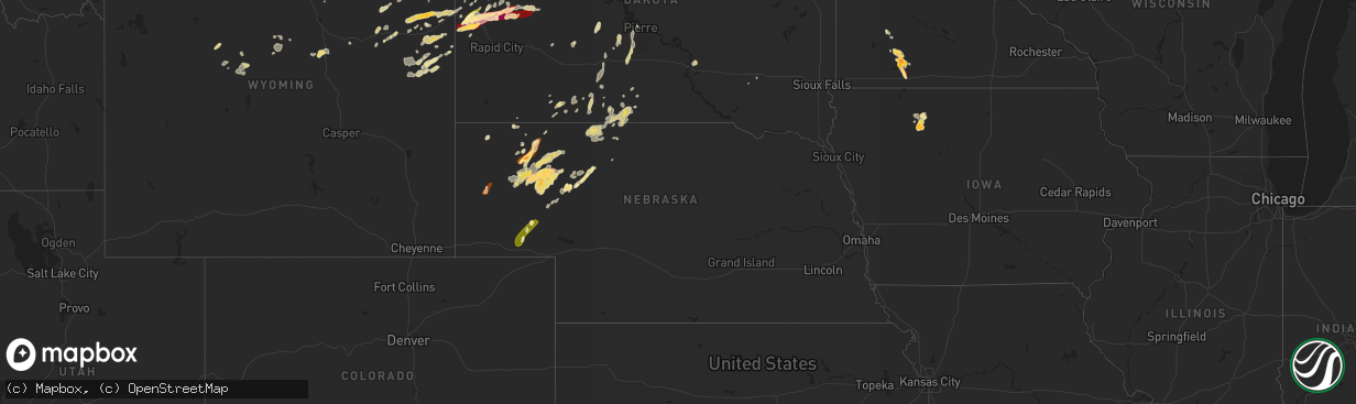
Hail Map in Nebraska on May 17, 2013
The weather event in Nebraska on May 17, 2013 includes Hail map. 12 states and 233 cities were impacted and suffered possible damage. The total estimated number of properties impacted is 1,639.
Want more than just the map?
Turn this storm into a full workflow.
- Owner + property data so you know who to knock
- OnDemand branded weather history reports to win the "did we even have hail?" argument
- RoofTrace estimate so reps stop guessing numbers at the door
Bought this map? Upgrade within 7 days and we'll credit the $230. (10-15 min setup call)
Hail
1,639
Estimated number of impacted properties by a 1.00" hail or larger176
Estimated number of impacted properties by a 1.75" hail or larger0
Estimated number of impacted properties by a 2.50" hail or largerStorm reports in Nebraska
Nebraska
| Date | Description |
|---|---|
| 05/17/20135:52 PM CDT | Quarter size hail was reported at estimated time of 552cdt. |
| 05/17/20135:17 PM CDT | Relayed through social media. |
| 05/17/20134:54 PM CDT | Chadron warning point received 3 separate reports of a tornado on the ground 7n of crawford. Tornado has since lifted back into the storm. |
| 05/17/20134:11 PM CDT | Most hail stones are half dollar size with a few stones golf ball size. Winds are estimated at 50 mph. |
| 05/17/20132:45 PM CDT | Hail ended at 153 pm. |
| 05/16/201311:00 PM CDT | Hail ranged in size from pea to shooter marble... Or approximately quarter size. |
| 05/16/201310:37 PM CDT | A local report indicates 1.50 inch wind near 4 ESE ASHBY |
| 05/16/20139:43 PM CDT | Dime to nickel size hail was covering the ground with the largest stones being quarter size. |
| 05/16/20138:53 PM CDT | Most stones were nickel to quarter size. |
| 05/16/20138:24 PM CDT | A local report indicates 1.50 inch wind near 13 NNW BINGHAM |
| 05/16/20138:20 PM CDT | A local report indicates 1.00 inch wind near 7 NW BINGHAM |
| 05/16/20138:10 PM CDT | A local report indicates 1.00 inch wind near 6 NE LISCO |
| 05/16/20138:00 PM CDT | Most stones were quarter to half dollar size. |
| 05/16/20138:00 PM CDT | Quarter to ping pong size hail was shown by a picture. |
| 05/16/20137:45 PM CDT | A local report indicates 1.00 inch wind near 2 E LAKESIDE |
| 05/16/20137:17 PM CDT | Walnut to silver dollar sized hail |
| 05/16/20137:12 PM CDT | Most hail stones are around quarter size with the largest stones being golf ball size. |
| 05/16/20137:08 PM CDT | A local report indicates 1.00 inch wind near 8 N LODGEPOLE |
All States Impacted by Hail Map on May 17, 2013
Cities Impacted by Hail Map on May 17, 2013
- Lodgepole, NE
- Bingham Lake, MN
- Osakis, MN
- Long Prairie, MN
- Greensboro, AL
- Alliance, NE
- Chadron, NE
- Ellsworth, NE
- Bingham, NE
- Newcastle, WY
- Deadwood, SD
- Sturgis, SD
- Teague, TX
- Valentine, NE
- Whitman, NE
- Rushville, NE
- Ashby, NE
- Gordon, NE
- Hay Springs, NE
- Merriman, NE
- Lakeside, NE
- Camp Crook, SD
- Calera, AL
- Weir, MS
- Saint Francis, SD
- Mission, SD
- Italy, TX
- Milford, TX
- Moorcroft, WY
- Mallard, IA
- Curlew, IA
- Havelock, IA
- Laurens, IA
- Shelby, AL
- Sylacauga, AL
- Newbern, AL
- Marion, AL
- Uniontown, AL
- Aberdeen, MS
- Okolona, MS
- Richland Springs, TX
- Clearmont, WY
- Moorhead, MN
- Comstock, MN
- Wolverton, MN
- Cody, NE
- Breckenridge, TX
- Newcastle, TX
- Graham, TX
- South Bend, TX
- Crawford, NE
- Emmetsburg, IA
- Union Center, SD
- Enning, SD
- White Owl, SD
- Maben, MS
- Mathiston, MS
- Sauk Centre, MN
- Devils Tower, WY
- Sundance, WY
- Porcupine, SD
- Belle Fourche, SD
- Marion Junction, AL
- Selma, AL
- Fort Pierre, SD
- Okaton, SD
- Lakefield, MN
- Jackson, MN
- Jeffers, MN
- Heron Lake, MN
- Windom, MN
- Storden, MN
- Carrollton, AL
- Aliceville, AL
- Midland, SD
- Upton, WY
- Houston, MS
- Kyle, SD
- Parkers Prairie, MN
- Prairie, MS
- Gillette, WY
- Rozet, WY
- Smackover, AR
- El Dorado, AR
- Barry, TX
- Frost, TX
- Purdon, TX
- Allen, SD
- Kilgore, NE
- Nenzel, NE
- Hyannis, NE
- Mantee, MS
- Pheba, MS
- Cedarbluff, MS
- West Point, MS
- Knoxville, AL
- Akron, AL
- Moundville, AL
- Norris, SD
- Mexia, TX
- Newell, SD
- Vale, SD
- Lisco, NE
- Brandon, MN
- Wakpala, SD
- Brooten, MN
- Georgiana, AL
- Pine Apple, AL
- Olney, TX
- Holliday, TX
- San Saba, TX
- Draper, SD
- Weston, WY
- Windthorst, TX
- Loving, TX
- Ekalaka, MT
- Capitol, MT
- Hammond, MT
- Meeteetse, WY
- Whitewood, SD
- Spearfish, SD
- Saint Onge, SD
- Stewart, MS
- Kilmichael, MS
- Brierfield, AL
- Centreville, AL
- Lamberton, MN
- Revere, MN
- Thermopolis, WY
- Beulah, WY
- Aladdin, WY
- Garfield, MN
- Bryson, TX
- Faulkton, SD
- Lead, SD
- Murdo, SD
- Wortham, TX
- Ten Sleep, WY
- Glenwood, MN
- Villard, MN
- Alexandria, MN
- Kaycee, WY
- Buffalo, WY
- Philip, SD
- Tuthill, SD
- Martin, SD
- Long Valley, SD
- Randolph, AL
- Cresbard, SD
- Crookston, NE
- Thomaston, AL
- Mount Holly, AR
- Westbrook, MN
- Lawley, AL
- Eutaw, AL
- Louann, AR
- Stephens, AR
- Bessemer, AL
- Strong, AR
- Ayrshire, IA
- Quinn, SD
- Safford, AL
- Rochelle, TX
- Blooming Grove, TX
- Eupora, MS
- Eagle Bend, MN
- Miltona, MN
- Havana, ND
- Dawson, TX
- Nelson, MN
- Ruthven, IA
- White River, SD
- Walnut Grove, MN
- Columbiana, AL
- Buffalo, TX
- Midland, TX
- Evansville, MN
- Mitchell, SD
- Nisland, SD
- Pontotoc, MS
- Wood, SD
- Northville, SD
- Montevallo, AL
- Worland, WY
- Lineville, AL
- Whitney, NE
- Chamberlain, SD
- Daviston, AL
- Pine Ridge, SD
- Winona, MS
- Duck Hill, MS
- Hulett, WY
- Parmelee, SD
- Voca, TX
- Woodland, MS
- Knoxville, TN
- Oak Ridge, TN
- Randolph, MS
- Houlka, MS
- Hyattville, WY
- Minatare, NE
- Ipswich, SD
- Wilsonville, AL
- Sterrett, AL
- Harpersville, AL
- Manderson, WY
- Pukwana, SD
- Calhoun City, MS
- Hettinger, ND
- Starkville, MS
- Alabaster, AL
- Melrose, MN
- Belgrade, MN
- Maplesville, AL
- Osage, WY
- Alexander City, AL
- Vardaman, MS
- Birmingham, AL
- Pelham, AL
- York, AL
- Gordo, AL
- Talladega, AL
- Brady, TX
- French Camp, MS
- Ethel, MS
- Mount Vernon, SD
- Rutland, ND
- Oshkosh, NE
- Dalton, NE
- Sidney, NE
- Gurley, NE
- Broadwater, NE
- Hemingford, NE


