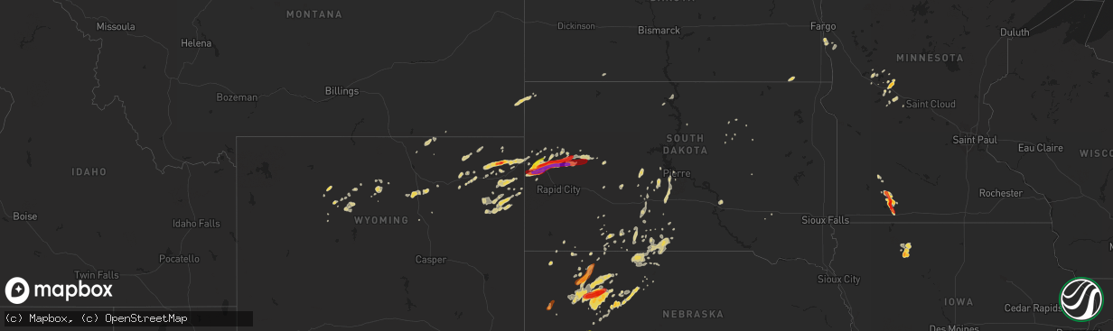
Hail Map on May 17, 2013
The weather event on May 17, 2013 includes Hail map. 12 states and 233 cities were impacted and suffered possible damage. The total estimated number of properties impacted is 11,534.
Want more than just the map?
Turn this storm into a full workflow.
- Owner + property data so you know who to knock
- OnDemand branded weather history reports to win the "did we even have hail?" argument
- RoofTrace estimate so reps stop guessing numbers at the door
Bought this map? Upgrade within 7 days and we'll credit the $230. (10-15 min setup call)
Hail
11,534
Estimated number of impacted properties by a 1.00" hail or larger16,500
Estimated number of impacted properties by a 1.75" hail or larger3,642
Estimated number of impacted properties by a 2.50" hail or largerStates Impacted by Hail Map on May 17, 2013
Storm reports
Wyoming
| Date | Description |
|---|---|
| 05/17/20136:20 PM CDT | A local report indicates 1.00 inch wind near 5 SE DOWNTOWN GILLETTE |
| 05/17/20135:45 PM CDT | Along highway 50 |
| 05/17/20135:45 PM CDT | Along highway 50 |
| 05/17/20135:23 PM CDT | A local report indicates 1.00 inch wind near 7 N DOWNTOWN GILLETTE |
| 05/17/20134:41 PM CDT | Hail accumulated one inch deep. |
| 05/16/201310:30 PM CDT | A local report indicates 1.00 inch wind near 3 SSW FOUR CORNERS |
| 05/16/20139:45 PM CDT | A local report indicates 1.00 inch wind near 7 WNW CLARETON |
| 05/16/20138:57 PM CDT | A local report indicates 1.00 inch wind near 9 S SUNDANCE |
| 05/16/20137:16 PM CDT | A local report indicates 2.50 inch wind near 3 SE DEVILS TOWER |
| 05/16/20137:15 PM CDT | A local report indicates 1.75 inch wind near DEVILS TOWER |
Minnesota
| Date | Description |
|---|---|
| 05/17/20136:30 PM CDT | A local report indicates 1.00 inch wind near 5 NE LAKEFIELD |
| 05/17/20136:10 PM CDT | Relayed by jackson county emergency management |
| 05/17/20135:45 PM CDT | Report was in the vicinity of wilder. |
| 05/17/20135:45 PM CDT | A local report indicates 2.00 inch wind near WINDOM |
| 05/17/20135:42 PM CDT | Branches 2 inches in diameter down. |
| 05/17/20135:40 PM CDT | A local report indicates 2.00 inch wind near WINDOM |
| 05/17/20135:35 PM CDT | A local report indicates 1.00 inch wind near 3 NW WINDOM |
| 05/17/20135:30 PM CDT | Lasted until 550 pm. |
| 05/17/20135:30 PM CDT | A local report indicates 1.00 inch wind near E WINDOM |
| 05/17/20135:30 PM CDT | Lasted until 540 pm. |
| 05/17/20135:30 PM CDT | Lasted until 550 pm. |
| 05/17/20135:25 PM CDT | A local report indicates 1.00 inch wind near 4 W WINDOM |
| 05/17/20135:22 PM CDT | A local report indicates 1.50 inch wind near WINDOM |
| 05/17/20135:20 PM CDT | A local report indicates 1.75 inch wind near 3 N WINDOM |
| 05/17/20135:20 PM CDT | Lasted until 540 pm. |
| 05/17/20135:20 PM CDT | A local report indicates 1.25 inch wind near 1 W WINDOM |
| 05/17/20135:15 PM CDT | A local report indicates 1.75 inch wind near 2 NW WINDOM |
| 05/17/20135:10 PM CDT | Lasted until 522 pm. |
| 05/17/20135:08 PM CDT | A local report indicates 1.00 inch wind near 3 NW WINDOM |
| 05/17/20134:20 PM CDT | A local report indicates 1.00 inch wind near 2 E STORDEN |
| 05/17/20132:04 AM CDT | Broken windshield on truck. |
| 05/17/20131:48 AM CDT | A local report indicates 1.00 inch wind near 8 W SAUK CENTRE |
Iowa
| Date | Description |
|---|---|
| 05/17/20136:45 PM CDT | Shave report |
| 05/17/20136:15 PM CDT | Shave report |
| 05/17/20135:27 PM CDT | Public report of heavy rainfall along with nickel to a few quarter sized hailstones. |
South Dakota
| Date | Description |
|---|---|
| 05/17/20136:40 PM CDT | A local report indicates 60 MPH wind near 3 WNW ROSEBUD |
| 05/17/20136:30 PM CDT | A local report indicates 1.00 inch wind near 7 NE BEAR BUTTE STATE P |
| 05/17/20136:15 PM CDT | A local report indicates 60 MPH wind near 7 N VETAL |
| 05/17/20136:15 PM CDT | A local report indicates 1.00 inch wind near 7 N VETAL |
| 05/17/20135:41 PM CDT | A local report indicates 1.75 inch wind near 5 SSW SAINT ONGE |
| 05/17/20135:38 PM CDT | A local report indicates 1.00 inch wind near 2 SSW SAINT ONGE |
| 05/17/20135:30 PM CDT | Mile marker 18 |
| 05/17/20135:29 PM CDT | A local report indicates 1.25 inch wind near 5 ESE DOWNTOWN SPEARFIS |
| 05/17/20135:26 PM CDT | A local report indicates 1.00 inch wind near 3 ESE DOWNTOWN SPEARFIS |
| 05/17/20134:20 PM CDT | Lasted 10 minutes |
| 05/17/20134:10 PM CDT | A local report indicates 1.00 inch wind near 1 E DOWNTOWN SPEARFISH |
| 05/17/201312:45 AM CDT | A local report indicates 1.00 inch wind near 8 WSW UNION CENTER |
| 05/17/201312:45 AM CDT | A local report indicates 60 MPH wind near 8 WSW UNION CENTER |
| 05/16/201310:58 PM CDT | A local report indicates 1.75 inch wind near DEADWOOD |
| 05/16/20138:51 PM CDT | Trained spotter reported 61 mph wind gust measured with anemometer |
| 05/16/20138:51 PM CDT | Trained spotter reported 61 mph wind gust measured with anemometer |
| 05/16/20138:16 PM CDT | Reported by mesonet wind equipment at hays airport. |
| 05/16/20138:15 PM CDT | Quarter sized hail reported |
| 05/16/20137:00 PM CDT | A local report indicates 1.00 inch wind near 5 S MISSION |
Texas
| Date | Description |
|---|---|
| 05/17/20136:49 PM CDT | A local report indicates 3.00 inch wind near NEWCASTLE |
| 05/17/20136:42 PM CDT | Hen egg hail mixed with quarters and golfballs fell for about 5 minutes ending at 647 pm. |
| 05/17/20136:39 PM CDT | Hen egg to cue ball...2.25 inch...hail |
| 05/17/20136:21 PM CDT | Small amount of golfball mixed with nickels and quarters |
| 05/17/20136:15 PM CDT | Just north of graham |
| 05/17/20136:14 PM CDT | A local report indicates 2.00 inch wind near GRAHAM |
| 05/17/20136:09 PM CDT | It is raining hail. Up to golfball size |
| 05/17/20136:07 PM CDT | A local report indicates 1.50 inch wind near GRAHAM |
| 05/17/20136:05 PM CDT | East side of graham |
| 05/17/20136:03 PM CDT | A local report indicates 2.50 inch wind near OLNEY |
| 05/17/20136:00 PM CDT | Larger than baseballs |
| 05/17/20135:59 PM CDT | A local report indicates 1.00 inch wind near GRAHAM |
| 05/17/20135:50 PM CDT | A local report indicates 60 MPH wind near RICHLAND SPRINGS |
| 05/17/20138:48 AM CDT | 1 mile w of teague |
| 05/17/20137:45 AM CDT | Quarter size hail reported 13 mi w of corsicana off of hwy 31. |
| 05/17/20137:43 AM CDT | Quarter hail in frost |
| 05/17/20137:30 AM CDT | Hail up to the size of golfballs was reported via cocorahs 1.3 miles wnw of frost. The hail dented cars and damaged shingles. |
| 05/16/20138:59 PM CDT | Golfball to tennis ball sized hail was reported 2-3 miles west of south bend |
| 05/16/20138:27 PM CDT | Tennis ball hail in eliasville |
| 05/16/20137:51 PM CDT | House near eliasville took direct hit from tornado. No details yet. |
| 05/16/20137:50 PM CDT | Second touchdown near eliasville...near the young/stephens county line. |
| 05/16/20137:35 PM CDT | Also seen on chasertv |
| 05/16/20137:10 PM CDT | Broadcast media chaser reported 3.5 inch hail |
Alabama
| Date | Description |
|---|---|
| 05/17/20132:50 PM CDT | Sighting of tornado on boyds chapel road near interstate 65. |
| 05/17/20132:46 PM CDT | Tornado reported at fort hampton rd and clem rd. Relayed by 911/ema. |
| 05/17/20132:45 PM CDT | This very short-lived tornado was part of the same storm that produced the south athens tornado. Damage was seen in a less than 1/4 mile swath between residences along |
| 05/17/20132:38 PM CDT | Structure and tree damage on hardiman road near ardmore. Tornado possible. |
| 05/17/20132:06 PM CDT | One inch in diameter branches snapped off of trees at mcconnell cemetery. Possible tornado. |
| 05/17/20132:05 PM CDT | Trees and powerlines down along moyers road. Additional damage just northeast around steelcase inc. Possible tornado. |
| 05/17/20132:04 PM CDT | Power lines reported down. Possible tornado. |
| 05/17/20132:00 PM CDT | Tornado initially touched down along roy long rd just west of u.s. Hwy 31. Several trees were snapped/uprooted around residential property. Max winds were determined to |
| 05/16/20139:15 PM CDT | Quarter size hail reported near morgan academy on the southwest side of the city of selma. The quarter size hail fell for about 15 minutes...and hail was covering the g |
| 05/16/20139:07 PM CDT | Quarter size hail reported in selma on the western side of town. Reported through social media. |
| 05/16/20137:48 PM CDT | Quarter size hail reported near marion. |
Oklahoma
| Date | Description |
|---|---|
| 05/17/20136:25 AM CDT | A local report indicates 66 MPH wind near 3 W GOULD |
| 05/17/20136:20 AM CDT | A local report indicates 59 MPH wind near 3 W GOULD |
| 05/17/20135:50 AM CDT | A local report indicates 69 MPH wind near 3 W GOULD |
North Dakota
| Date | Description |
|---|---|
| 05/16/201310:53 PM CDT | A local report indicates 60 MPH wind near 6 N LARK |
| 05/16/20139:29 PM CDT | Winds estimated 50 mph with gusts to 60 mph just started at the time of call. Patio table flipped over with large pine trees bending. |
| 05/16/20139:15 PM CDT | Arb observer also reported 1.50 inches of rain as of 945 pm cdt. |
| 05/16/20139:05 PM CDT | Spotter estimates 45 mph winds with gusts to 60 mph. Torrential rains. Will follow up with any additional reports. |
| 05/16/20137:34 PM CDT | Pea sized hail started at 1925 and was still ongoing at the time of call |
Tennessee
| Date | Description |
|---|---|
| 05/17/20132:55 PM CDT | Nws huntsville survey team noted a tree with large limbs snapped along hwy 7 just east of pleasant view drive. |
| 05/16/20137:35 PM CDT | Couple of trees down near hwy 61 between oliver springs and clinton |
Nebraska
| Date | Description |
|---|---|
| 05/17/20135:52 PM CDT | Quarter size hail was reported at estimated time of 552cdt. |
| 05/17/20135:17 PM CDT | Relayed through social media. |
| 05/17/20134:54 PM CDT | Chadron warning point received 3 separate reports of a tornado on the ground 7n of crawford. Tornado has since lifted back into the storm. |
| 05/17/20134:11 PM CDT | Most hail stones are half dollar size with a few stones golf ball size. Winds are estimated at 50 mph. |
| 05/17/20132:45 PM CDT | Hail ended at 153 pm. |
| 05/16/201311:00 PM CDT | Hail ranged in size from pea to shooter marble... Or approximately quarter size. |
| 05/16/201310:37 PM CDT | A local report indicates 1.50 inch wind near 4 ESE ASHBY |
| 05/16/20139:43 PM CDT | Dime to nickel size hail was covering the ground with the largest stones being quarter size. |
| 05/16/20138:53 PM CDT | Most stones were nickel to quarter size. |
| 05/16/20138:24 PM CDT | A local report indicates 1.50 inch wind near 13 NNW BINGHAM |
| 05/16/20138:20 PM CDT | A local report indicates 1.00 inch wind near 7 NW BINGHAM |
| 05/16/20138:10 PM CDT | A local report indicates 1.00 inch wind near 6 NE LISCO |
| 05/16/20138:00 PM CDT | Most stones were quarter to half dollar size. |
| 05/16/20138:00 PM CDT | Quarter to ping pong size hail was shown by a picture. |
| 05/16/20137:45 PM CDT | A local report indicates 1.00 inch wind near 2 E LAKESIDE |
| 05/16/20137:17 PM CDT | Walnut to silver dollar sized hail |
| 05/16/20137:12 PM CDT | Most hail stones are around quarter size with the largest stones being golf ball size. |
| 05/16/20137:08 PM CDT | A local report indicates 1.00 inch wind near 8 N LODGEPOLE |
Mississippi
| Date | Description |
|---|---|
| 05/17/20134:28 AM CDT | A local report indicates 1.75 inch wind near 7 ENE MONTPELIER |
Cities Impacted by Hail Map on May 17, 2013
- Lodgepole, NE
- Bingham Lake, MN
- Osakis, MN
- Long Prairie, MN
- Greensboro, AL
- Alliance, NE
- Chadron, NE
- Ellsworth, NE
- Bingham, NE
- Newcastle, WY
- Deadwood, SD
- Sturgis, SD
- Teague, TX
- Valentine, NE
- Whitman, NE
- Rushville, NE
- Ashby, NE
- Gordon, NE
- Hay Springs, NE
- Merriman, NE
- Lakeside, NE
- Camp Crook, SD
- Calera, AL
- Weir, MS
- Saint Francis, SD
- Mission, SD
- Italy, TX
- Milford, TX
- Moorcroft, WY
- Mallard, IA
- Curlew, IA
- Havelock, IA
- Laurens, IA
- Shelby, AL
- Sylacauga, AL
- Newbern, AL
- Marion, AL
- Uniontown, AL
- Aberdeen, MS
- Okolona, MS
- Richland Springs, TX
- Clearmont, WY
- Moorhead, MN
- Comstock, MN
- Wolverton, MN
- Cody, NE
- Breckenridge, TX
- Newcastle, TX
- Graham, TX
- South Bend, TX
- Crawford, NE
- Emmetsburg, IA
- Union Center, SD
- Enning, SD
- White Owl, SD
- Maben, MS
- Mathiston, MS
- Sauk Centre, MN
- Devils Tower, WY
- Sundance, WY
- Porcupine, SD
- Belle Fourche, SD
- Marion Junction, AL
- Selma, AL
- Fort Pierre, SD
- Okaton, SD
- Lakefield, MN
- Jackson, MN
- Jeffers, MN
- Heron Lake, MN
- Windom, MN
- Storden, MN
- Carrollton, AL
- Aliceville, AL
- Midland, SD
- Upton, WY
- Houston, MS
- Kyle, SD
- Parkers Prairie, MN
- Prairie, MS
- Gillette, WY
- Rozet, WY
- Smackover, AR
- El Dorado, AR
- Barry, TX
- Frost, TX
- Purdon, TX
- Allen, SD
- Kilgore, NE
- Nenzel, NE
- Hyannis, NE
- Mantee, MS
- Pheba, MS
- Cedarbluff, MS
- West Point, MS
- Knoxville, AL
- Akron, AL
- Moundville, AL
- Norris, SD
- Mexia, TX
- Newell, SD
- Vale, SD
- Lisco, NE
- Brandon, MN
- Wakpala, SD
- Brooten, MN
- Georgiana, AL
- Pine Apple, AL
- Olney, TX
- Holliday, TX
- San Saba, TX
- Draper, SD
- Weston, WY
- Windthorst, TX
- Loving, TX
- Ekalaka, MT
- Capitol, MT
- Hammond, MT
- Meeteetse, WY
- Whitewood, SD
- Spearfish, SD
- Saint Onge, SD
- Stewart, MS
- Kilmichael, MS
- Brierfield, AL
- Centreville, AL
- Lamberton, MN
- Revere, MN
- Thermopolis, WY
- Beulah, WY
- Aladdin, WY
- Garfield, MN
- Bryson, TX
- Faulkton, SD
- Lead, SD
- Murdo, SD
- Wortham, TX
- Ten Sleep, WY
- Glenwood, MN
- Villard, MN
- Alexandria, MN
- Kaycee, WY
- Buffalo, WY
- Philip, SD
- Tuthill, SD
- Martin, SD
- Long Valley, SD
- Randolph, AL
- Cresbard, SD
- Crookston, NE
- Thomaston, AL
- Mount Holly, AR
- Westbrook, MN
- Lawley, AL
- Eutaw, AL
- Louann, AR
- Stephens, AR
- Bessemer, AL
- Strong, AR
- Ayrshire, IA
- Quinn, SD
- Safford, AL
- Rochelle, TX
- Blooming Grove, TX
- Eupora, MS
- Eagle Bend, MN
- Miltona, MN
- Havana, ND
- Dawson, TX
- Nelson, MN
- Ruthven, IA
- White River, SD
- Walnut Grove, MN
- Columbiana, AL
- Buffalo, TX
- Midland, TX
- Evansville, MN
- Mitchell, SD
- Nisland, SD
- Pontotoc, MS
- Wood, SD
- Northville, SD
- Montevallo, AL
- Worland, WY
- Lineville, AL
- Whitney, NE
- Chamberlain, SD
- Daviston, AL
- Pine Ridge, SD
- Winona, MS
- Duck Hill, MS
- Hulett, WY
- Parmelee, SD
- Voca, TX
- Woodland, MS
- Knoxville, TN
- Oak Ridge, TN
- Randolph, MS
- Houlka, MS
- Hyattville, WY
- Minatare, NE
- Ipswich, SD
- Wilsonville, AL
- Sterrett, AL
- Harpersville, AL
- Manderson, WY
- Pukwana, SD
- Calhoun City, MS
- Hettinger, ND
- Starkville, MS
- Alabaster, AL
- Melrose, MN
- Belgrade, MN
- Maplesville, AL
- Osage, WY
- Alexander City, AL
- Vardaman, MS
- Birmingham, AL
- Pelham, AL
- York, AL
- Gordo, AL
- Talladega, AL
- Brady, TX
- French Camp, MS
- Ethel, MS
- Mount Vernon, SD
- Rutland, ND
- Oshkosh, NE
- Dalton, NE
- Sidney, NE
- Gurley, NE
- Broadwater, NE
- Hemingford, NE