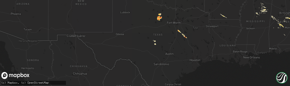
Hail Map in Texas on May 17, 2013
The weather event in Texas on May 17, 2013 includes Hail map. 12 states and 233 cities were impacted and suffered possible damage. The total estimated number of properties impacted is 9,032.
Want more than just the map?
Turn this storm into a full workflow.
- Owner + property data so you know who to knock
- OnDemand branded weather history reports to win the "did we even have hail?" argument
- RoofTrace estimate so reps stop guessing numbers at the door
Bought this map? Upgrade within 7 days and we'll credit the $230. (10-15 min setup call)
Hail
9,032
Estimated number of impacted properties by a 1.00" hail or larger4,364
Estimated number of impacted properties by a 1.75" hail or larger3,642
Estimated number of impacted properties by a 2.50" hail or largerStorm reports in Texas
Texas
| Date | Description |
|---|---|
| 05/17/20136:49 PM CDT | A local report indicates 3.00 inch wind near NEWCASTLE |
| 05/17/20136:42 PM CDT | Hen egg hail mixed with quarters and golfballs fell for about 5 minutes ending at 647 pm. |
| 05/17/20136:39 PM CDT | Hen egg to cue ball...2.25 inch...hail |
| 05/17/20136:21 PM CDT | Small amount of golfball mixed with nickels and quarters |
| 05/17/20136:15 PM CDT | Just north of graham |
| 05/17/20136:14 PM CDT | A local report indicates 2.00 inch wind near GRAHAM |
| 05/17/20136:09 PM CDT | It is raining hail. Up to golfball size |
| 05/17/20136:07 PM CDT | A local report indicates 1.50 inch wind near GRAHAM |
| 05/17/20136:05 PM CDT | East side of graham |
| 05/17/20136:03 PM CDT | A local report indicates 2.50 inch wind near OLNEY |
| 05/17/20136:00 PM CDT | Larger than baseballs |
| 05/17/20135:59 PM CDT | A local report indicates 1.00 inch wind near GRAHAM |
| 05/17/20135:50 PM CDT | A local report indicates 60 MPH wind near RICHLAND SPRINGS |
| 05/17/20138:48 AM CDT | 1 mile w of teague |
| 05/17/20137:45 AM CDT | Quarter size hail reported 13 mi w of corsicana off of hwy 31. |
| 05/17/20137:43 AM CDT | Quarter hail in frost |
| 05/17/20137:30 AM CDT | Hail up to the size of golfballs was reported via cocorahs 1.3 miles wnw of frost. The hail dented cars and damaged shingles. |
| 05/16/20138:59 PM CDT | Golfball to tennis ball sized hail was reported 2-3 miles west of south bend |
| 05/16/20138:27 PM CDT | Tennis ball hail in eliasville |
| 05/16/20137:51 PM CDT | House near eliasville took direct hit from tornado. No details yet. |
| 05/16/20137:50 PM CDT | Second touchdown near eliasville...near the young/stephens county line. |
| 05/16/20137:35 PM CDT | Also seen on chasertv |
| 05/16/20137:10 PM CDT | Broadcast media chaser reported 3.5 inch hail |
All States Impacted by Hail Map on May 17, 2013
Cities Impacted by Hail Map on May 17, 2013
- Lodgepole, NE
- Bingham Lake, MN
- Osakis, MN
- Long Prairie, MN
- Greensboro, AL
- Alliance, NE
- Chadron, NE
- Ellsworth, NE
- Bingham, NE
- Newcastle, WY
- Deadwood, SD
- Sturgis, SD
- Teague, TX
- Valentine, NE
- Whitman, NE
- Rushville, NE
- Ashby, NE
- Gordon, NE
- Hay Springs, NE
- Merriman, NE
- Lakeside, NE
- Camp Crook, SD
- Calera, AL
- Weir, MS
- Saint Francis, SD
- Mission, SD
- Italy, TX
- Milford, TX
- Moorcroft, WY
- Mallard, IA
- Curlew, IA
- Havelock, IA
- Laurens, IA
- Shelby, AL
- Sylacauga, AL
- Newbern, AL
- Marion, AL
- Uniontown, AL
- Aberdeen, MS
- Okolona, MS
- Richland Springs, TX
- Clearmont, WY
- Moorhead, MN
- Comstock, MN
- Wolverton, MN
- Cody, NE
- Breckenridge, TX
- Newcastle, TX
- Graham, TX
- South Bend, TX
- Crawford, NE
- Emmetsburg, IA
- Union Center, SD
- Enning, SD
- White Owl, SD
- Maben, MS
- Mathiston, MS
- Sauk Centre, MN
- Devils Tower, WY
- Sundance, WY
- Porcupine, SD
- Belle Fourche, SD
- Marion Junction, AL
- Selma, AL
- Fort Pierre, SD
- Okaton, SD
- Lakefield, MN
- Jackson, MN
- Jeffers, MN
- Heron Lake, MN
- Windom, MN
- Storden, MN
- Carrollton, AL
- Aliceville, AL
- Midland, SD
- Upton, WY
- Houston, MS
- Kyle, SD
- Parkers Prairie, MN
- Prairie, MS
- Gillette, WY
- Rozet, WY
- Smackover, AR
- El Dorado, AR
- Barry, TX
- Frost, TX
- Purdon, TX
- Allen, SD
- Kilgore, NE
- Nenzel, NE
- Hyannis, NE
- Mantee, MS
- Pheba, MS
- Cedarbluff, MS
- West Point, MS
- Knoxville, AL
- Akron, AL
- Moundville, AL
- Norris, SD
- Mexia, TX
- Newell, SD
- Vale, SD
- Lisco, NE
- Brandon, MN
- Wakpala, SD
- Brooten, MN
- Georgiana, AL
- Pine Apple, AL
- Olney, TX
- Holliday, TX
- San Saba, TX
- Draper, SD
- Weston, WY
- Windthorst, TX
- Loving, TX
- Ekalaka, MT
- Capitol, MT
- Hammond, MT
- Meeteetse, WY
- Whitewood, SD
- Spearfish, SD
- Saint Onge, SD
- Stewart, MS
- Kilmichael, MS
- Brierfield, AL
- Centreville, AL
- Lamberton, MN
- Revere, MN
- Thermopolis, WY
- Beulah, WY
- Aladdin, WY
- Garfield, MN
- Bryson, TX
- Faulkton, SD
- Lead, SD
- Murdo, SD
- Wortham, TX
- Ten Sleep, WY
- Glenwood, MN
- Villard, MN
- Alexandria, MN
- Kaycee, WY
- Buffalo, WY
- Philip, SD
- Tuthill, SD
- Martin, SD
- Long Valley, SD
- Randolph, AL
- Cresbard, SD
- Crookston, NE
- Thomaston, AL
- Mount Holly, AR
- Westbrook, MN
- Lawley, AL
- Eutaw, AL
- Louann, AR
- Stephens, AR
- Bessemer, AL
- Strong, AR
- Ayrshire, IA
- Quinn, SD
- Safford, AL
- Rochelle, TX
- Blooming Grove, TX
- Eupora, MS
- Eagle Bend, MN
- Miltona, MN
- Havana, ND
- Dawson, TX
- Nelson, MN
- Ruthven, IA
- White River, SD
- Walnut Grove, MN
- Columbiana, AL
- Buffalo, TX
- Midland, TX
- Evansville, MN
- Mitchell, SD
- Nisland, SD
- Pontotoc, MS
- Wood, SD
- Northville, SD
- Montevallo, AL
- Worland, WY
- Lineville, AL
- Whitney, NE
- Chamberlain, SD
- Daviston, AL
- Pine Ridge, SD
- Winona, MS
- Duck Hill, MS
- Hulett, WY
- Parmelee, SD
- Voca, TX
- Woodland, MS
- Knoxville, TN
- Oak Ridge, TN
- Randolph, MS
- Houlka, MS
- Hyattville, WY
- Minatare, NE
- Ipswich, SD
- Wilsonville, AL
- Sterrett, AL
- Harpersville, AL
- Manderson, WY
- Pukwana, SD
- Calhoun City, MS
- Hettinger, ND
- Starkville, MS
- Alabaster, AL
- Melrose, MN
- Belgrade, MN
- Maplesville, AL
- Osage, WY
- Alexander City, AL
- Vardaman, MS
- Birmingham, AL
- Pelham, AL
- York, AL
- Gordo, AL
- Talladega, AL
- Brady, TX
- French Camp, MS
- Ethel, MS
- Mount Vernon, SD
- Rutland, ND
- Oshkosh, NE
- Dalton, NE
- Sidney, NE
- Gurley, NE
- Broadwater, NE
- Hemingford, NE


