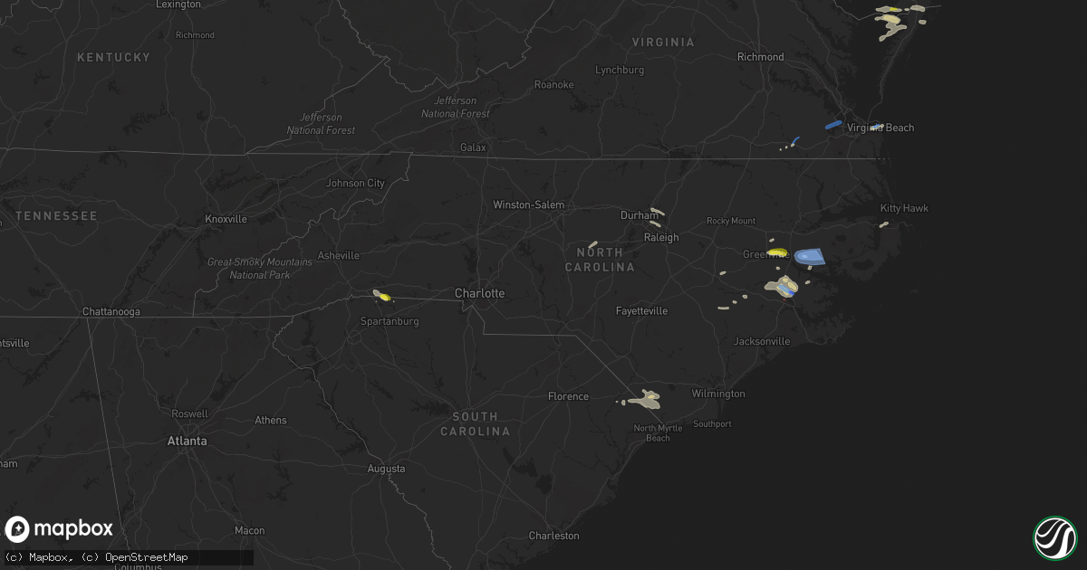
Hail Map in North Carolina on May 16, 2022
Get this storm
May 16 map
$229
one time, instant access
Download today. No call, no setup
Keep the $229
Bought the map and want the full workflow? Apply the entire $229 to a subscription within 7 days. None of it is wasted.
Every map, not just this one
This buys you this map. Subscription and you get every map we run, in the markets you choose from a few cities to whole states to nationwide. Plus real-time alerts the moment a storm fires.
Contact data
Name, contact info, occupancy, even credit band for addresses in the footprint. You go from where it hit to who to call.
Become the source they trust
Unlimited branding weather history reports on demand. You already have the documented answer ready for the property owner, and you are the one who showed up with it.
Property data and RoofTrace estimates
Pull up any address you have got, its value and the exact code rules for that jurisdiction, straight from One Click Code. Then RoofTrace estimates the squares, pitch, and roof value, priced the way you price.
Storm reports in North Carolina
North Carolina
| Date | Description |
|---|---|
| 05/16/20226:55 PM CDT | Duke energy reports 282 customers without power in the grifton area. Time estimated by radar. |
| 05/16/20225:35 PM CDT | Public reported quarter sized hail in the ernul area. Also reported medium sized tree limbs down. |
| 05/16/20225:30 PM CDT | Multiple trees down at ocean dr and sonny rd. |
| 05/16/20225:25 PM CDT | Public called to report quarter sized hail in the ernul/askin area. Causing some dings in metal. |
| 05/16/20225:16 PM CDT | A power outage was caused by downed trees causing damage to their equipment. Time estimated by radar. |
| 05/16/20225:09 PM CDT | A tree down near the intersection of north pine street and nowell street. Time estimated by radar. |
| 05/16/20225:08 PM CDT | A power outage was caused by downed trees causing damage to equipment. Time estimated by radar. |
| 05/16/20225:08 PM CDT | Trained spotter reported metal roofing displaced from home and trees down in the pinetown area. Home weather station recorded a max gust of 84 mph. |
| 05/16/20225:05 PM CDT | A tree down near the intersection of holly mountain road and stargate road. Time estimated by radar. |
| 05/16/20224:58 PM CDT | Flag pole bent in half. Pea size hail fell as well. |
| 05/16/20224:54 PM CDT | Power outages centered around new hill caused by downed trees causing damage to equipment. Time estimated by radar. |
| 05/16/20224:50 PM CDT | Large branches downed and a few rotted trees snapped. Time estimated by radar. |
| 05/16/20224:43 PM CDT | Farm building blown down. Time estimated based on radar. |
| 05/16/20224:31 PM CDT | Multiple trees down along cedar branch ct. |
| 05/16/20224:24 PM CDT | A lot of quarter size hail fell at this location. |
| 05/16/20222:28 PM CDT | Tree snapped on jolley ln. |
| 05/16/20222:10 PM CDT | Multiple trees down around town. Time estimated by radar. |
| 05/16/20222:05 PM CDT | Washington county emergency manager reported 10-12 power poles down... Blocking hwy 99. Time based on radar. |
| 05/16/20222:00 PM CDT | Multiple trees down... Relayed via twitter. |
| 05/16/20221:55 PM CDT | Martin county emergency management reported a tree through the roof of a mobile home. Time based on radar. |
| 05/16/202212:30 PM CDT | Thunderstorm wind damage reported on gurganus road around 130 pm. Some roof damage and a trampoline was blown into a motor vehicle. |
| 05/16/202212:27 PM CDT | Straight line wind damage consisting of minor roof damage and tractor truck blown over in the vicinity of true vine road and us highway 13. Time estimated by radar. |
| 05/16/202212:02 PM CDT | A social media post showing a few large tree limbs down in reidsville. |
| 05/16/202211:57 AM CDT | One tree down along camp dan valley rd. |
| 05/16/202211:51 AM CDT | One tree down on settle bridge road. |
| 05/16/20227:51 AM CDT | At 1251 PM EDT, a severe thunderstorm was located over Wentworth, moving east at 35 mph. HAZARD...60 mph wind gusts and quarter size hail. SOURCE...Radar indicated. IMPACT...Hail damage to vehicles is expected. Expect wind damage to roofs, siding, and trees. Locations impacted include... Eden... Reidsville... Wentworth... Bethel... Camp Springs... Providence... and Jericho. |
| 05/16/20224:13 AM CDT | At 913 PM EDT, severe thunderstorms were located along a line extending from near Redbug to near Loris, moving east at 25 mph. HAZARD...60 mph wind gusts and quarter size hail. SOURCE...Radar indicated. IMPACT...Minor hail damage to vehicles is possible. Expect wind damage to trees and power lines. Locations impacted include... Loris, Bethel, Lake Waccamaw, Freeland, Honey Island, Nakina, Old Dock, Mollie, Exum, Bughill, Freeman, Pireway, Dulah, Ash, Goretown, Delco, Crusoe Island, Bolton and Loris Community Hospital. |
| 05/16/20223:46 AM CDT | At 846 PM EDT, a severe thunderstorm was located over Fairfield Harbour, or near James City, moving southeast at 25 mph. HAZARD...60 mph wind gusts and quarter size hail. SOURCE...Radar indicated. IMPACT...Hail damage to vehicles is expected. Expect wind damage to roofs, siding, and trees. Locations impacted include... New Bern, Havelock, James City, Cayton, Florence, Janeiro, Grantsboro, Royal, Riverdale, Olympia, Whortonsville, Croatan, Maribel, Nc Pamlico, Merritt, Neuse Forest, Cherry Branch Ferry Terminal, Fairfield Harbour, Minnesott Beach Ferry and Coastal Carolina Regional Airport. |
| 05/16/20223:12 AM CDT | At 811 PM EDT, a severe thunderstorm was located near Jasper, or 15 miles northwest of New Bern, moving east at 40 mph. HAZARD...60 mph wind gusts and quarter size hail. SOURCE...Radar indicated. IMPACT...Hail damage to vehicles is expected. Expect wind damage to roofs, siding, and trees. Locations impacted include... New Bern, Trent Woods, River Bend, Askins, Cayton, Fort Barnwell, Jasper, Tuscarora, Rhems, Ernul, Bridgeton, Cove City, Pollocksville and Trenton. |
| 05/16/20222:42 AM CDT | At 740 PM EDT, a severe thunderstorm was located over Kinston, moving east at 35 mph. HAZARD...60 mph wind gusts. SOURCE...Radar indicated. IMPACT...Expect damage to roofs, siding, and trees. Locations impacted include... Kinston, Grifton, Phillips Crossroads, Fort Barnwell, Dawson, Graingers, Wyse Fork, Kinston Regional Jetport, Dover, Cove City, Gardnerville and Trenton. |
| 05/16/20221:07 AM CDT | At 607 PM EDT, severe thunderstorms were located along a line extending from near Cary to 7 miles west of Garner to near Fuquay-Varina, moving east at 40 mph. HAZARD...60 mph wind gusts and quarter size hail. SOURCE...Radar indicated. IMPACT...Hail damage to vehicles is expected. Expect wind damage to roofs, siding, and trees. Locations impacted include... Raleigh, Cary, Smithfield, Garner, Fuquay-Varina, Clayton, Angier, Apex, Holly Springs and Morrisville. |
| 05/16/20221:07 AM CDT | At 606 PM EDT, a severe thunderstorm was located over Askins, or 10 miles north of New Bern, moving east at 30 mph. HAZARD...60 mph wind gusts and quarter size hail. SOURCE...Radar indicated. IMPACT...Hail damage to vehicles is expected. Expect wind damage to roofs, siding, and trees. Locations impacted include... New Bern, Havelock, James City, Trent Woods, Askins, Cayton, Olympia, Grantsboro, Croatan, Riverdale, Maribel, Ernul, Neuse Forest, Fairfield Harbour, Coastal Carolina Regional Airport, Bayboro, Alliance, Bridgeton and Stonewall. |
| 05/16/20221:02 AM CDT | At 602 PM EDT, severe thunderstorms were located along a line extending from near Bunn to near Zebulon to 9 miles north of Clayton, moving east at 35 mph. HAZARD...60 mph wind gusts and quarter size hail. SOURCE...Radar indicated. IMPACT...Hail damage to vehicles is expected. Expect wind damage to roofs, siding, and trees. Locations impacted include... Rocky Mount, Tarboro, Nashville, Wilson, Elm City, Fremont, Bailey, Princeville, Sharpsburg and Pinetops. |
| 05/16/202212:55 AM CDT | At 555 PM EDT, a severe thunderstorm was located near Bunyan, or near River Road, moving east at 30 mph. HAZARD...60 mph wind gusts and quarter size hail. SOURCE...Radar indicated. IMPACT...Hail damage to vehicles is expected. Expect wind damage to roofs, siding, and trees. Locations impacted include... Washington, River Road, Belhaven, Pinetown, Ransomville, Pungo, Pamlico Beach, Bunyan, Pike Road, Winsteadville, Bayview, Sidney Crossroads, Terra Ceia, Yeatesville, Goose Creek State Park, Bayview Ferry Terminal, Long Acre VFD, Sydney Crossroads and Pantego. |
| 05/16/202212:37 AM CDT | At 537 PM EDT, a severe thunderstorm was located over Fort Barnwell, or 14 miles south of Ayden, moving east at 20 mph. HAZARD...60 mph wind gusts and quarter size hail. SOURCE...Radar indicated. IMPACT...Hail damage to vehicles is expected. Expect wind damage to roofs, siding, and trees. Locations impacted include... New Bern, Vanceboro, Askins, Fort Barnwell, Jasper, Wilmar, Ernul and Cove City. |
| 05/16/202212:17 AM CDT | At 516 PM EDT, a severe thunderstorm was located near Siler City, moving east at 40 mph. HAZARD...60 mph wind gusts and quarter size hail. SOURCE...Radar indicated. IMPACT...Hail damage to vehicles is expected. Expect wind damage to roofs, siding, and trees. Locations impacted include... Raleigh, Cary, Sanford, Pittsboro, Lillington, Siler City, Fuquay-Varina, Angier, Goldston and Apex. |
| 05/16/202212:15 AM CDT | At 515 PM EDT, a severe thunderstorm was located near East Carolina University, or near Greenville, moving east at 20 mph. HAZARD...60 mph wind gusts and quarter size hail. SOURCE...Radar indicated. IMPACT...Hail damage to vehicles is expected. Expect wind damage to roofs, siding, and trees. Locations impacted include... Greenville, Washington, Winterville, River Road, House, Pactolus, Black Jack, Bunyan, Old Ford, East Carolina University, Pitt Greenville Airport, Dowdy Ficklen Stadium, Chocowinity, Washington Park, Grimesland and Simpson. |
| 05/16/202212:12 AM CDT | At 512 PM EDT, a severe thunderstorm was located 7 miles south of Creedmoor, moving east at 35 mph. HAZARD...60 mph wind gusts and quarter size hail. SOURCE...Radar indicated. IMPACT...Hail damage to vehicles is expected. Expect wind damage to roofs, siding, and trees. Locations impacted include... Raleigh, Durham, Creedmoor, Louisburg, Wake Forest, Butner, Zebulon, Franklinton, Bunn and Knightdale. |
| 05/15/202210:26 PM CDT | At 326 PM EDT, a severe thunderstorm was located over Franklinton, or 7 miles west of Louisburg, moving east at 40 mph. HAZARD...60 mph wind gusts and quarter size hail. SOURCE...Radar indicated. IMPACT...Hail damage to vehicles is expected. Expect wind damage to roofs, siding, and trees. Locations impacted include... Louisburg, Franklinton, Bunn, Spring Hope, Youngsville, Castalia, Centerville and Ingleside. |
| 05/15/202210:22 PM CDT | At 322 PM EDT, a severe thunderstorm was located over Nixonton, or near Elizabeth City State University, moving east at 30 mph. HAZARD...60 mph wind gusts and quarter size hail. SOURCE...Radar indicated. IMPACT...Minor damage to vehicles is possible. Expect wind damage to trees and powerlines. This severe thunderstorm will be near... Elizabeth City around 325 PM EDT. Elizabeth City State University and Weeksville around 330 PM EDT. Camden and Whitehall Shores around 335 PM EDT. Shiloh around 340 PM EDT. Indiantown and Old Trap around 345 PM EDT. Grandy and Corolla around 400 PM EDT.Other locations impacted by this severe thunderstorm include BobWhite Fork, Poplar Branch, Spot, Glen Cove, Barco, Pasquotank,Jacocks, Spences Corner, Goose Creek and Harvey Point. |
| 05/15/202210:09 PM CDT | At 309 PM EDT, a severe thunderstorm was located 6 miles east of Columbus, or 6 miles northeast of Landrum, moving southeast at 20 mph. HAZARD...60 mph wind gusts and penny size hail. SOURCE...Radar indicated. IMPACT...Expect damage to trees and power lines. Locations impacted include... Boiling Springs SC, Landrum, Mayo, Chesnee, Cowpens National Battlefield, Lake Bowen, Green Creek, Harris, Fingerville and Campobello. |
| 05/15/20229:49 PM CDT | At 248 PM EDT, a severe thunderstorm was located over Price, or near Stoneville, moving east at 40 mph. HAZARD...60 mph wind gusts and quarter size hail. SOURCE...Radar indicated. IMPACT...Hail damage to vehicles is expected. Expect wind damage to roofs, siding, and trees. Locations impacted include... Danville... Eden... Wentworth... Yanceyville... Bethel... Stoneville... and Providence.This includes The following Locations The Martinsville Speedway,Martinsville Airport, and Danville Airport. |
| 05/15/20229:43 PM CDT | At 243 PM EDT, a severe thunderstorm was located near Williamston, moving northeast at 55 mph. HAZARD...60 mph wind gusts and nickel size hail. SOURCE...Radar indicated. IMPACT...Expect damage to roofs, siding, and trees. Locations impacted include... Williamston, Plymouth, Hinson, Westover, Pleasant Grove, Scuppernong, Mackeys, Roper, Jamesville, Smithwick, Everetts and Dardens. |
| 05/15/20228:25 PM CDT | Tstm wind gusts toppled 2 trees onto road in 1100 block of mollie drive... Just south of mollie block drive |
| 05/15/20228:20 PM CDT | Tstm wind gusts knocked over a tree onto 7 creek highway near intersection of chair factory road |
| 05/15/20227:50 PM CDT | Tree down near 74 and 211 near council |
| 05/15/20227:38 PM CDT | Trained spotter reported a tornado near exit 416 |
| 05/15/20227:33 PM CDT | Duke energy reports 1...221 customers without power across much of western new bern and the trent woods area. |
All States Impacted by Hail Map on May 16, 2022
Cities Impacted by Hail Map on May 16, 2022
- Littleton, MA
- Westford, MA
- Goltry, OK
- Millsboro, DE
- Lewes, DE
- Harbeson, DE
- Seneca, NE
- Orlando, OK
- Preston, ID
- Franklin, ID
- Amorita, OK
- Cherokee, OK
- Anthony, KS
- Waldron, KS
- Burlington, OK
- New Church, VA
- Pocomoke City, MD
- Horntown, VA
- Little Falls, NY
- Dolgeville, NY
- Middleville, NY
- Herkimer, NY
- Mohawk, NY
- Siler City, NC
- Bear Creek, NC
- Dagsboro, DE
- Lorenzo, TX
- Idalou, TX
- Lubbock, TX
- Fairview, OK
- Virginia Beach, VA
- Ratliff City, OK
- Graham, OK
- Fairfax, OK
- Ralston, OK
- Pawnee, OK
- Trappe, MD
- Nichols, SC
- Amarillo, TX
- Campobello, SC
- Ocean City, MD
- Berlin, MD
- Vermontville, NY
- Laurel, DE
- Tahoka, TX
- Wilson, TX
- Red Creek, NY
- Wolcott, NY
- Sterling, NY
- Townsend, MT
- Onancock, VA
- Bloxom, VA
- Parksley, VA
- Newsoms, VA
- Franklin, VA
- Courtland, VA
- Alva, OK
- Hurley, NY
- Germantown, NY
- West Hurley, NY
- Catskill, NY
- Woodstock, NY
- West Camp, NY
- Kingston, NY
- Saugerties, NY
- Tivoli, NY
- Red Hook, NY
- Barrytown, NY
- Saint Regis Falls, NY
- Binghamton, NY
- Vestal, NY
- Port Crane, NY
- Brackney, PA
- Friendsville, PA
- Bernville, PA
- Myerstown, PA
- Richland, PA
- Womelsdorf, PA
- Marion Station, MD
- Crisfield, MD
- Hannacroix, NY
- West Coxsackie, NY
- Ravena, NY
- Bozeman, MT
- Locust Grove, OK
- Bishopville, MD
- Salisbury, MD
- Pittsville, MD
- Parsonsburg, MD
- Whaleyville, MD
- Showell, MD
- Snow Hill, MD
- Willards, MD
- Hammond, NY
- Marshall, OK
- Temple, OK
- Grantham, NH
- Bearsville, NY
- Morton, TX
- Churubusco, NY
- Ellenburg Center, NY
- Ellenburg Depot, NY
- Sperry, OK
- Skiatook, OK
- Smyer, TX
- Wolfforth, TX
- Anton, TX
- Ropesville, TX
- Levelland, TX
- Shallowater, TX
- Chesnee, SC
- Fairlee, VT
- Orford, NH
- Lyme, NH
- Slaton, TX
- Post, TX
- Heuvelton, NY
- Petersburg, TX
- Floydada, TX
- Coxsackie, NY
- Climax, NY
- Earlton, NY
- Hancock, NY
- Starlight, PA
- Long Eddy, NY
- Fishs Eddy, NY
- East Branch, NY
- Lakewood, PA
- Pleasant Mount, PA
- Lake Como, PA
- Equinunk, PA
- Clayton, NM
- Chelmsford, MA
- Goldsboro, NC
- Pawhuska, OK
- Columbia, NC
- Manns Harbor, NC
- Philipsburg, PA
- Morrisdale, PA
- Osceola Mills, PA
- Houtzdale, PA
- Kylertown, PA
- Bigler, PA
- West Decatur, PA
- Wallaceton, PA
- Woodland, PA
- Allport, PA
- Ames, OK
- Grenville, NM
- Helena, OK
- Carmen, OK
- Manchester, OK
- Salina, OK
- Bradford, VT
- Roswell, NM
- Milnesand, NM
- Causey, NM
- Rogers, NM
- Pep, NM
- Elida, NM
- Hazelton, KS
- Wake Forest, NC
- Creedmoor, NC
- Andrews Air Force Base, MD
- Upper Marlboro, MD
- Bethel, DE
- Chesapeake Beach, MD
- Fort Belvoir, VA
- Fairfax Station, VA
- Bryans Road, MD
- Tracys Landing, MD
- Secretary, MD
- Delmar, DE
- Georgetown, DE
- Clifton, VA
- Friendship, MD
- Vienna, MD
- North Beach, MD
- Woodbridge, VA
- Huntingtown, MD
- Owings, MD
- Mardela Springs, MD
- Oxon Hill, MD
- Lorton, VA
- Clinton, MD
- Rhodesdale, MD
- Burke, VA
- Dunkirk, MD
- Aquasco, MD
- Springfield, VA
- East New Market, MD
- Millville, DE
- Alexandria, VA
- Seaford, DE
- Frankford, DE
- Brandywine, MD
- Linkwood, MD
- Cambridge, MD
- Waldorf, MD
- Sunderland, MD
- Manassas, VA
- Prince Frederick, MD
- Sharptown, MD
- Cheltenham, MD
- Ocean View, DE
- Hurlock, MD
- Fort Washington, MD
- Accokeek, MD
- Temple Hills, MD
- Boykins, VA
- Kinston, NC
- Deep Run, NC
- Bath, NC
- Washington, NC
- Wilmot, NH
- Andover, NH
- Warner, NH
- Johnson City, NY
- Endicott, NY
- Crosbyton, TX
- Greenville, NC
- Grimesland, NC
- Mosquero, NM
- Moriarty, NM
- Elizaville, NY
- Tupper Lake, NY
- Walton, NY
- Franklin, NY
- Sidney Center, NY
- Durham, NC
- Raleigh, NC
- Geuda Springs, KS
- Comanche, OK
- Santa Fe, NM
- Whitney Point, NY
- Masterson, TX
- Panhandle, TX
- Valentine, NE
- Westfield, PA
- Jasper, NY
- Addison, NY
- Knoxville, PA
- Woodhull, NY
- Troupsburg, NY
- Cameron Mills, NY
- Timber Lake, SD
- Hebron, MD
- Fairmont, OK
- Douglas, OK
- Chatham, NY
- Hillsdale, NY
- Craryville, NY
- Hudson, NY
- Spencertown, NY
- Ghent, NY
- New Bern, NC
- Vanceboro, NC
- Cove City, NC
- Dover, NC
- Chocowinity, NC
- Grifton, NC
- Ernul, NC
- Wells, NY
- Indian Lake, NY
- Conchas Dam, NM
- Crowell, TX
- Hanover, NH
- Etna, NH
- Topsham, VT
- Newbury, VT
- East Corinth, VT
- Enfield, NH
- Childress, TX
- Matador, TX
- Aurora, NC
- Edward, NC
- Wallops Island, VA
- Temperanceville, VA
- Ulster Park, NY
- Quantico, MD
- Raton, NM
- Thedford, NE
- Sedan, KS
- Delmar, MD
- Tilghman, MD
- Woolford, MD
- Bristow, VA
- Washington, DC
- Oxford, MD
- Bethany Beach, DE
- Lyon Mountain, NY
- Owls Head, NY
- Chateaugay, NY
- Kunkletown, PA
- Brodheadsville, PA
- Stroudsburg, PA
- East Stroudsburg, PA
- Bartonsville, PA
- Kresgeville, PA
- Effort, PA
- Tannersville, PA
- Gilbert, PA
- Saylorsburg, PA
- Scotrun, PA
- Henryville, PA
- Duke, OK
- Frederick, OK
- Ringwood, OK
- Cleo Springs, OK
- Stokes, NC
- Robersonville, NC
- Nanticoke, MD
- Princess Anne, MD
- Columbus, NC
- Tryon, NC
- Inman, SC
- Rutherfordton, NC
- Tell, TX
- Vaughn, NM
- Natchez, MS
- Walters, OK
- Dalhart, TX
- Jackson, LA
- Saint Francisville, LA
- Brownfield, TX
- Meadow, TX
- Moreauville, LA
- Lettsworth, LA
- Crosby, MS
- Gloster, MS
- Centreville, MS
- Roxie, MS
- Pinetown, NC
- Ralls, TX
- Loris, SC
- Chadbourn, NC
- Whiteville, NC
- Green Sea, SC
- Nakina, NC
- Clarendon, NC
- Tabor City, NC
- Paducah, TX
- Justiceburg, TX
- Snyder, TX
- Meadville, MS
- San Jon, NM
- Las Vegas, NM
- Stratford, TX
- Bard, NM
- Santa Rosa, NM
- Tylertown, MS
- Marland, OK
- Red Rock, OK
- Randlett, OK
- Ribera, NM
- Albertson, NC
- Mount Olive, NC
- Hartley, TX
- Gallatin Gateway, MT
- Waynoka, OK
- Aline, OK
- Sand Springs, OK
- Enid, OK
- Waukomis, OK
- Duncan, OK
- Lima, MT
- Worden, MT
- Austerlitz, NY
- Ransom Canyon, TX
- Plattsburgh, NY
- Chazy, NY
- West Chazy, NY
- Champlain, NY
- Mooers, NY
- Altona, NY
- Canaan, NY
- Nicholville, NY
- Pantego, NC
- Belhaven, NC
- Plymouth, NC
- Scranton, NC
- Montour Falls, NY
- Odessa, NY
- Watkins Glen, NY
- Campbell, NY
- Beaver Dams, NY
- Painted Post, NY
- Moravia, NY
- Auburn, NY
- Owego, NY
- Syracuse, NY
- Pennellville, NY
- Baldwinsville, NY
- Central Square, NY
- Williamstown, NY
- Clay, NY
- West Monroe, NY
- Constantia, NY
- Warners, NY
- Brewerton, NY
- Liverpool, NY
- Redfield, NY
- Camden, NY
- Jamaica, VT
- Petersburg, NY
- East Schodack, NY
- Averill Park, NY
- West Sand Lake, NY
- Cropseyville, NY
- Berlin, NY
- Stamford, VT
- West Dover, VT
- Wilmington, VT
- Nassau, NY
- East Dover, VT
- Pownal, VT
- Shaftsbury, VT
- Castleton On Hudson, NY
- Sand Lake, NY
- East Greenbush, NY
- Wardsboro, VT
- North Pownal, VT
- West Townshend, VT
- Hoosick Falls, NY
- North Bennington, VT
- Bennington, VT
- Williamstown, MA
- Townshend, VT
- Greenwich, NY
- Schuylerville, NY
- Salem, NY
- Argyle, NY
- Cossayuna, NY
- Granville, NY
- North Granville, NY
- Comstock, NY
- Whitehall, NY
- Fort Ann, NY
- Hastings, PA
- Lanse, PA
- Karthaus, PA
- Patton, PA
- Moshannon, PA
- Madera, PA
- Marsteller, PA
- Munson, PA
- Winburne, PA
- Cherry Tree, PA
- Nicktown, PA
- Drifting, PA
- Westover, PA
- Hawk Run, PA
- Flinton, PA
- Spangler, PA
- Grassflat, PA
- Saint Boniface, PA
- Glen Hope, PA
- Brisbin, PA
- Frenchville, PA
- New Millport, PA
- Irvona, PA
- Saint Benedict, PA
- Carrolltown, PA
- Coalport, PA
- Northern Cambria, PA
- La Jose, PA
- Starrucca, PA
- Roscoe, NY
- Deposit, NY
- Susquehanna, PA
- South Gibson, PA
- New Milford, PA
- Herrick Center, PA
- Hamden, NY
- Thompson, PA
- Delhi, NY
- Kingsley, PA
- Andes, NY
- Union Dale, PA
- Preston Park, PA
- Downsville, NY
- Delancey, NY
- Suffolk, VA
- Smithfield, VA
- Windsor, VA
- White Plains, MD
- Occoquan, VA
- La Plata, MD
- Indian Head, MD
- Royal Oak, MD
- Madison, MD
- Tipton, OK
- Altus, OK
- Elmer, OK
- Chillicothe, TX
- Gould, OK
- Spur, TX
- Altus Afb, OK
- Afton, TX
- Vernon, TX
- Davidson, OK
- Cee Vee, TX
- Hollis, OK
- Odell, TX
- Eldorado, OK
- Dickens, TX
- Quanah, TX
- Roaring Springs, TX
- Mcadoo, TX
- Headrick, OK
- Olustee, OK
- Pottstown, PA


