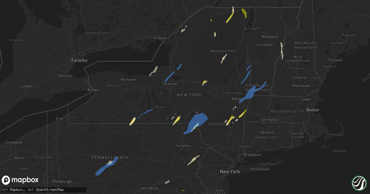
Hail Map in New York on May 16, 2022
Get this storm
May 16 map
$229
one time, instant access
Download today. No call, no setup
Keep the $229
Bought the map and want the full workflow? Apply the entire $229 to a subscription within 7 days. None of it is wasted.
Every map, not just this one
This buys you this map. Subscription and you get every map we run, in the markets you choose from a few cities to whole states to nationwide. Plus real-time alerts the moment a storm fires.
Contact data
Name, contact info, occupancy, even credit band for addresses in the footprint. You go from where it hit to who to call.
Become the source they trust
Unlimited branding weather history reports on demand. You already have the documented answer ready for the property owner, and you are the one who showed up with it.
Property data and RoofTrace estimates
Pull up any address you have got, its value and the exact code rules for that jurisdiction, straight from One Click Code. Then RoofTrace estimates the squares, pitch, and roof value, priced the way you price.
Storm reports in New York
New York
| Date | Description |
|---|---|
| 05/16/20223:55 PM CDT | Tree down blocking hathaway rd. |
| 05/16/20223:54 PM CDT | Tree down blocking pearl st. |
| 05/16/20223:53 PM CDT | Tree down blocking roadway... South rd at old saratoga rd. |
| 05/16/20223:52 PM CDT | A local report indicates 1.00 inch wind near MOOERS |
| 05/16/20223:52 PM CDT | Tree on roadway. |
| 05/16/20223:52 PM CDT | Trees down in mooers |
| 05/16/20223:50 PM CDT | Tree down blocking 2 lanes of taconic parkway. |
| 05/16/20223:43 PM CDT | Tree down on wires. |
| 05/16/20223:42 PM CDT | Tree down in roadway. |
| 05/16/20223:36 PM CDT | Large tree limb down. Time estimated from radar. |
| 05/16/20223:34 PM CDT | Tree down blocking roadway. |
| 05/16/20223:34 PM CDT | Tree blocking roadway. |
| 05/16/20223:32 PM CDT | Tree down blocking 2 lanes of taconic parkway. |
| 05/16/20223:32 PM CDT | Trees and wires down. |
| 05/16/20223:30 PM CDT | Trees and wires down. |
| 05/16/20223:26 PM CDT | Tree down |
| 05/16/20223:24 PM CDT | Trees and wires down. |
| 05/16/20223:22 PM CDT | Reports of downed trees. |
| 05/16/20223:21 PM CDT | Wires down. |
| 05/16/20223:20 PM CDT | Trees down in mooers |
| 05/16/20223:20 PM CDT | A local report indicates 1.00 inch wind near MOOERS |
| 05/16/20223:20 PM CDT | Multiple trees down |
| 05/16/20223:16 PM CDT | Wires down. |
| 05/16/20223:15 PM CDT | Tree and wires down. |
| 05/16/20223:10 PM CDT | Trees and wires down |
| 05/16/20223:10 PM CDT | A local report indicates 1.25 inch wind near 3 W SAUGERTIES |
| 05/16/20223:09 PM CDT | Trees and wires down. |
| 05/16/20223:05 PM CDT | Tree and wire down on a home on goodridge road. |
| 05/16/20223:05 PM CDT | Downed trees near bruce st/1st st. |
| 05/16/20223:01 PM CDT | Multiple trees and wires down. |
| 05/16/20223:00 PM CDT | Tree down |
| 05/16/20223:00 PM CDT | Tree and wires down. |
| 05/16/20223:00 PM CDT | Wires down on greenwich ave and main street and hill street. |
| 05/16/20223:00 PM CDT | A local report indicates 1.00 inch wind near 3 NW SAUGERTIES |
| 05/16/20223:00 PM CDT | Tree and wires down on north street. |
| 05/16/20222:57 PM CDT | Tree down on road. |
| 05/16/20222:55 PM CDT | Power pole down |
| 05/16/20222:54 PM CDT | Numerous trees and powerlines down in ogdensburg. Several structures have also sustained minor damage. |
| 05/16/20222:45 PM CDT | Corrects time of previous report: tree and wire down on a home on goodridge road. |
| 05/16/20222:30 PM CDT | Several trees uprooted near the i-88 exit. Time estimated from radar. |
| 05/16/20222:26 PM CDT | A local report indicates 1.00 inch wind near ELLENBURG CENTER |
| 05/16/20222:23 PM CDT | Law enforcement reported trees down on power and cable lines on fletcher road. Time estimated from radar. |
| 05/16/20222:22 PM CDT | Several trees down between merrill and ellenburg center. Road crews have already removed trees. |
| 05/16/20222:08 PM CDT | Trees and wires down. |
| 05/16/20222:08 PM CDT | Tree down on road. |
| 05/16/20222:04 PM CDT | Trees and wires down. Time approximate. |
| 05/16/20222:00 PM CDT | Trees and lines down. |
| 05/16/20222:00 PM CDT | Trees and wires down. |
| 05/16/20221:53 PM CDT | Large limb fell on house. |
| 05/16/20221:53 PM CDT | Trees and wires down. |
| 05/16/20221:52 PM CDT | A local report indicates 1.00 inch wind near NICHOLVILLE |
| 05/16/20221:52 PM CDT | Trees and lines down. |
| 05/16/20221:50 PM CDT | Multiple reports of trees and wires down in the village of walton. |
| 05/16/20221:42 PM CDT | Tree and wires down across county highway 18. |
| 05/16/20221:30 PM CDT | Corrects previous tstm wnd dmg report from 4 s sanford. Several trees topped and trees down near mcclure along route 17. |
| 05/16/20221:23 PM CDT | Trees and lines down across the road. Social media report. |
| 05/16/20221:16 PM CDT | Several reports of trees and lines down. |
| 05/16/20221:15 PM CDT | Several trees topped and trees down near mcclure along route 17. |
| 05/16/20221:05 PM CDT | Large tree uprooted. |
| 05/16/202212:52 PM CDT | A local report indicates 1.00 inch wind near NICHOLVILLE |
| 05/16/202212:50 PM CDT | Trees and lines down in the town of hastings. |
| 05/16/202212:50 PM CDT | A local report indicates 58 MPH wind near 2 W EUCLID |
| 05/16/202212:46 PM CDT | One inch hail report from facebook. |
| 05/16/202212:45 PM CDT | Trees and lines down in the town of west monroe. |
| 05/16/202212:42 PM CDT | Trees and lines down. |
| 05/16/202212:40 PM CDT | Corrects previous hail report from 1 ene binghamton. Picture of hail with a nickel for comparison; was slightly larger than the nickel. |
| 05/16/202212:37 PM CDT | Report from mping: half dollar |
| 05/16/202212:36 PM CDT | Report from mping: 1-inch tree limbs broken; shingles blown off. |
| 05/16/202212:35 PM CDT | Tree down on house. |
| 05/16/202212:33 PM CDT | A local report indicates 1.00 inch wind near 2 SSW SALISBURY |
| 05/16/202212:32 PM CDT | Tree down on road. Time estimated from radar. |
| 05/16/202212:30 PM CDT | Telephone pole and wires down. |
| 05/16/202212:25 PM CDT | Several trees down on gaskin rd... River road. |
| 05/16/202212:17 PM CDT | Tree and wires down on vehicle on washington st. Time estimated from radar. |
| 05/16/202212:16 PM CDT | Tree and wires down on caroline st near park ave. Time estimated from radar. |
| 05/16/202212:12 PM CDT | Large tree limb across rt 175 in the town of onondaga. |
| 05/16/202212:06 PM CDT | A local report indicates 58 MPH wind near 3 NE NEW HOPE |
| 05/16/202212:05 PM CDT | Trees down. |
| 05/16/202211:53 AM CDT | Tree and wires down. Time estimated by radar. |
| 05/16/202211:45 AM CDT | Tree down blocking road. Time estimated from radar. |
| 05/16/202211:41 AM CDT | A davis weather station at roachs farm measured at 59 mph gust during a micro burst but was shelted from the southwest. |
| 05/16/202211:40 AM CDT | A 90 mph microburst was determined to have hit roach`s farm in venice... Ny. There were four barns that sustained roof damage with metal panels being lofted. Some of th |
| 05/16/202211:40 AM CDT | Hardwoord treet uprooted. |
| 05/16/202211:39 AM CDT | A farm building had several metal panels blown out and lofted to the northeast. |
| 05/16/202211:36 AM CDT | Tree and wires down at the corner of nys rt 90 and 34b. Time estimated by radar. |
| 05/16/202210:52 AM CDT | Tree down in the road. Time estimated from radar. |
| 05/16/202210:45 AM CDT | Tree and wires down. |
| 05/16/202210:40 AM CDT | Tree and wires down. |
| 05/16/202210:40 AM CDT | Tree down on house. |
| 05/16/202210:40 AM CDT | Trees and wires down on road time estimated from radar. |
| 05/16/202210:32 AM CDT | Tree and wires down. Time estimated from radar. |
| 05/16/202210:32 AM CDT | Tree and wires down. Time estimated from radar. |
| 05/16/202210:32 AM CDT | Dozens of trees snapped and uprooted and a trailer flipped on its side. |
| 05/16/20227:36 AM CDT | At 1236 PM EDT, severe thunderstorms were located along a line extending from near Fair Haven Beach State Park to near Cato, moving northeast at 30 mph. HAZARD...60 mph wind gusts and penny size hail. SOURCE...Radar indicated. IMPACT...Expect damage to trees and power lines. Locations impacted include... Oswego, Fulton, Fair Haven Beach State Park, Cato, Nine Mile Point, Battle Island State Park, Scriba, Volney, Sterling and Phoenix. |
| 05/16/20227:36 AM CDT | At 1235 PM EDT, severe thunderstorms were located along a line extending from near Canoga to Levanna to King Ferry to near Locke, moving north at 35 mph. HAZARD...60 mph wind gusts and quarter size hail. SOURCE...Radar indicated. IMPACT...Hail damage to vehicles is expected. Expect wind damage to roofs, siding, and trees. Locations impacted include... Onondaga, Syracuse, Clay, Auburn, Lysander, Van Buren, Baldwinsville, North Syracuse, Seneca Falls and Solvay. |
| 05/16/20226:41 AM CDT | At 1140 AM EDT, severe thunderstorms were located along a line extending from Bath to near East Corning, moving northeast at 35 mph. HAZARD...60 mph wind gusts and quarter size hail. SOURCE...Radar indicated. IMPACT...Hail damage to vehicles is expected. Expect wind damage to roofs, siding, and trees. Locations impacted include... Ithaca, Corning, Big Flats, Horseheads, Bath, Newfield, Penn Yan, Hector, Romulus and Cayuga Heights. |
| 05/16/20221:59 AM CDT | At 659 PM EDT, a severe thunderstorm was located over Ozone Park, or near Crown Heights, moving northeast at 35 mph. HAZARD...60 mph wind gusts and penny size hail. SOURCE...Radar indicated. IMPACT...Expect damage to trees and power lines. This severe thunderstorm will be near... Jamaica and Flushing around 705 PM EDT. Valley Stream and Lynbrook around 710 PM EDT. Great Neck and Throgs Neck Bridge around 715 PM EDT. Garden City and Mineola around 720 PM EDT. |
| 05/16/202212:27 AM CDT | At 526 PM EDT, a severe thunderstorm was located over Danbury, moving northeast at 45 mph. HAZARD...60 mph wind gusts and penny size hail. SOURCE...Radar indicated. IMPACT...Expect damage to trees and power lines. This severe thunderstorm will be near... Brookfield around 530 PM EDT. Newtown around 535 PM EDT. Southbury around 550 PM EDT. Naugatuck and Prospect around 555 PM EDT. Waterbury and Wolcott around 600 PM EDT. |
| 05/15/202211:12 PM CDT | At 412 PM EDT, severe thunderstorms were located along a line extending from near Duanesburg to near Feura Bush to Milton to near Sheffield, moving northeast at 50 mph. HAZARD...60 mph wind gusts and quarter size hail. SOURCE...Radar indicated. IMPACT...Hail damage to vehicles is expected. Expect wind damage to roofs, siding, and trees. Locations impacted include... Albany, Schenectady, Troy, Clifton Park, Rotterdam, East Greenbush, Cohoes, Watervliet, Rensselaer, Colonie, Scotia, Hudson, Mechanicville, Catskill, Saugerties, Delmar, Latham, Guilderland, Niskayuna and Duanesburg. |
| 05/15/202210:44 PM CDT | At 344 PM EDT, severe thunderstorms were located along a line extending from 7 miles southeast of Little Falls to near St. Johnsville to near Canajoharie, moving northeast at 40 mph. HAZARD...60 mph wind gusts and penny size hail. SOURCE...Radar indicated. IMPACT...Expect damage to roofs, siding, and trees. Locations impacted include... Gloversville, Fort Plain, St. Johnsville, Ephratah, Mayfield, Cranberry Creek, Caroga Lake Public Campground, Northampton Beach Public Campground, Caroga Lake, Oppenheim, Nelliston, Bleecker, Meco, Sweets Crossing, Pinnacle, Lotville, Broadalbin Junction, Mindenville, Fical Corners and Tomantown. |
| 05/15/202210:41 PM CDT | At 340 PM EDT, a severe thunderstorm was located over Burlington International Airport, moving north at 20 mph. Reports of down trees on route 22A associated with this storm HAZARD...60 mph wind gusts. SOURCE...Emergency management. IMPACT...Expect damage to trees and powerlines. Locations impacted include... Essex Junction, South Burlington, Burlington International Airport, Burlington, Winooski, Colchester, Essex Junction Village, St. Albans City, Williston, South Hero, Georgia, St. George, Grand Isle, Essex, Georgia Center, Milton, Richmond, St. Albans Town, Westford and Shelburne. |
| 05/15/202210:40 PM CDT | At 340 PM EDT, a severe thunderstorm was located near Unionville, or 9 miles southwest of Middletown, moving northeast at 60 mph. HAZARD...60 mph wind gusts and penny size hail. SOURCE...Radar indicated. IMPACT...Expect damage to trees and power lines. This severe thunderstorm will be near... Florida around 345 PM EDT. Goshen around 350 PM EDT. |
| 05/15/202210:38 PM CDT | At 338 PM EDT, a severe thunderstorm was located over Ellenburg Center, moving northeast at 20 mph. HAZARD...60 mph wind gusts and quarter size hail. SOURCE...Radar indicated. IMPACT...Minor hail damage to vehicles is possible. Expect wind damage to trees and powerlines. Locations impacted include... Churubusco, Ellenburg Depot, Ellenburg, Irona, Harrigan, Mooers Forks, Ellenburg Center, Alder Bend and Cannon Corners. |
| 05/15/202210:26 PM CDT | At 326 PM EDT, severe thunderstorms were located along a line extending from near Grahamsville to near Ellenville to near Sussex, moving northeast at 50 mph. HAZARD...60 mph wind gusts and quarter size hail. SOURCE...Radar indicated. IMPACT...Hail damage to vehicles is expected. Expect wind damage to roofs, siding, and trees. Locations impacted include... Kingston, New Paltz, Ellenville, Saugerties, Wallkill, Milton, Plattekill, Hurley, Highland, Modena, High Falls, Kerhonkson, Tillson, West Hurley, Napanoch, Saugerties South, Port Ewen, Marlboro, Lake Katrine and Olivebridge. |
| 05/15/202210:19 PM CDT | At 319 PM EDT, severe thunderstorms were located along a line extending from 10 miles southwest of Cedar Island State Park to 10 miles southwest of Pitcairn to 30 miles south of Wanakena, moving northeast at 40 mph. HAZARD...60 mph wind gusts and penny size hail. SOURCE...Radar indicated. IMPACT...Expect damage to trees and powerlines. Locations impacted include... Potsdam, Gouverneur, Canton, Ogdensburg, Oswegatchie, Lisbon, De Kalb, Fowler, Parishville, Colton, Morley, Degrasse, Richville, Hammond, Cranberry Lake, Madrid, Rensselaer Falls, Edwardsville, Hermon and Chipman. |
| 05/15/202210:13 PM CDT | At 313 PM EDT, severe thunderstorms were located along a line extending from near East Meredith to near Arkville to Swan Lake, moving northeast at 50 mph. HAZARD...60 mph wind gusts and quarter size hail. SOURCE...Radar indicated. IMPACT...Hail damage to vehicles is expected. Expect wind damage to roofs, siding, and trees. Locations impacted include... Hunter, Jefferson, Woodstock, Windham, Gilboa, Prattsville, West Hurley, North-South Lake Campground, Woodland Valley Campground, Livingstonville, North Blenheim, West Shokan, Kenneth L Wilson Campground, Preston-Potter Hollow, Phoenicia, Preston Hollow, Mount Tremper, Lanesville, Shandaken and Durham. |
| 05/15/202210:10 PM CDT | At 309 PM EDT, severe thunderstorms were located along a line extending from near Exeter Center to near Milford to near East Meredith, moving east at 40 mph. HAZARD...60 mph wind gusts and quarter size hail. SOURCE...Radar indicated. IMPACT...Hail damage to vehicles is expected. Expect wind damage to roofs, siding, and trees. Locations impacted include... Amsterdam, Johnstown, Cobleskill, Canajoharie, Fonda, Jefferson, Duanesburg, Berne, Fort Plain, Ephratah, Middleburgh, Summit, Schoharie, Richmondville, Sharon Springs, Fort Johnson, Delanson, Ames, Breakabeen and Livingstonville. |
| 05/15/202210:09 PM CDT | At 309 PM EDT, severe thunderstorms were located along a line extending from 8 miles northeast of Lowville to 9 miles northwest of McKeever to 6 miles northeast of Forestport, moving northeast at 15 mph. HAZARD...60 mph wind gusts. SOURCE...Radar indicated. IMPACT...Expect damage to roofs, siding, and trees. Locations impacted include... Old Forge, Limekiln Lake Campground, Eagle Bay, Big Moose, McKeever, Nicks Lake Campground, Alger Island Public Campground, Little Rapids, Beaver River, Moshier Falls, Atwell, Minnehaha, Thendara, Carter Station, Lyon Lake, First Lake, Wolf Lake Landing, Keepawa, Mountain Lodge and Brandreth. |
| 05/15/202210:00 PM CDT | At 300 PM EDT, severe thunderstorms were located along a line extending from near Holland Patent to near Frankfort to near Richfield Springs, moving northeast at 50 mph. HAZARD...60 mph wind gusts and penny size hail. SOURCE...Radar indicated. IMPACT...Expect damage to roofs, siding, and trees. Locations impacted include... Johnstown, Ilion, Herkimer, Little Falls, Mohawk, Frankfort, Fort Plain, Dolgeville, St. Johnsville, Ephratah, Ohio, Newport, Stratford, Middleville, Poland, Cold Brook, Jordanville, Caroga Lake, Caroga Lake Public Campground and Northwood. |
| 05/15/20229:57 PM CDT | At 257 PM EDT, a severe thunderstorm was located over Hartwick, or 9 miles southwest of Cooperstown, moving northeast at 45 mph. HAZARD...60 mph wind gusts. SOURCE...Radar indicated. IMPACT...Expect damage to roofs, siding, and trees. Locations impacted include... Oneonta, Worcester, Middlefield, Hartwick, Maryland, Cooperstown, Edmeston, Westville, Pittsfield and Springfield. |
| 05/15/20229:47 PM CDT | At 247 PM EDT, a severe thunderstorm was located over Bryants Mill, moving north at 25 mph. HAZARD...60 mph wind gusts and quarter size hail. SOURCE...Radar indicated. IMPACT...Minor hail damage to vehicles is possible. Expect wind damage to trees and powerlines. Locations impacted include... Churubusco, Merrill, Bryants Mill, Chateaugay, Lyon Mountain, Ellenburg Depot, Ellenburg, Earlville, Harrigan, Ellenburg Center, Owls Head, Chasm Falls, Standish, Brainardsville and Wolf Pond. |
| 05/15/20229:24 PM CDT | At 224 PM EDT, severe thunderstorms were located along a line extending from near Sidney to near Deposit to near Stalker to Prompton, moving northeast at 35 mph. HAZARD...60 mph wind gusts. SOURCE...Radar indicated. IMPACT...Expect damage to roofs, siding, and trees. Locations impacted include... Rockland, Oneonta, Carbondale, Liberty, Bethel, Sidney, Damascus, Neversink, South Fallsburg and Walton. |
| 05/15/20229:16 PM CDT | At 215 PM EDT, severe thunderstorms were located along a line extending from 8 miles northeast of Taberg to near Poolville to near Norwich to near Morris, moving northeast at 55 mph. HAZARD...60 mph wind gusts and penny size hail. SOURCE...Radar indicated. IMPACT...Expect damage to roofs, siding, and trees. Locations impacted include... Utica, Rome, Oneida, Kirkland, Lenox, Norwich, Lee, Verona, Westmoreland and Vienna. |
| 05/15/20229:12 PM CDT | At 212 PM EDT, severe thunderstorms were located along a line extending from Mexico Point State Park to 5 miles southeast of Pulaski to 5 miles south of Redfield, moving northeast at 45 mph. HAZARD...60 mph wind gusts. SOURCE...Radar indicated. IMPACT...Expect damage to trees and power lines. Locations impacted include... Sandy Island Beach State Park, Stony Point, Lowville, Pulaski, Adams, Redfield, Selkirk Shores State Park, Highmarket, Adams Center and Southwick Beach State Park.This includes Interstate 81 between exits 35 and 42. |
| 05/15/20229:09 PM CDT | At 209 PM EDT, a severe thunderstorm was located near Downsville, or 8 miles east of Walton, moving northeast at 20 mph. HAZARD...60 mph wind gusts and penny size hail. SOURCE...Radar indicated. IMPACT...Expect damage to roofs, siding, and trees. Locations impacted include... Delhi, Roxbury, Colchester, Kortright, Hamden, Andes, Stamford, Hobart, Bovina Center and Downsville. |
| 05/15/20228:52 PM CDT | At 152 PM EDT, a severe thunderstorm was located over Caroga Lake, or 12 miles northwest of Gloversville, moving north at 30 mph. HAZARD...60 mph wind gusts and nickel size hail. SOURCE...Radar indicated. IMPACT...Expect damage to roofs, siding, and trees. Locations impacted include... Wells, Caroga Lake, Caroga Lake Public Campground, Sacandaga Campground, Arietta, Wheelerville, Canada Lake, Rudeston, Blackbridge, Averys Place, Bliss Corner, Stewart Landing, Whitehouse, Shaker Place, Peters Corners, Piseco, Higgins Bay, Upper Benson, Gilmantown and Newkirk. |
| 05/15/20228:34 PM CDT | At 133 PM EDT, a severe thunderstorm was located over Herrickville, or 9 miles north of Wyalusing, moving northeast at 45 mph. HAZARD...60 mph wind gusts and penny size hail. SOURCE...Radar indicated. IMPACT...Expect damage to roofs, siding, and trees. Locations impacted include... Rush, Orwell, Herrick, Rome, Le Raysville, Little Meadows, Friendsville, Warren Center, Rushville and Brackney. |
| 05/15/20228:28 PM CDT | At 127 PM EDT, a severe thunderstorm was located near Plainville, or near Baldwinsville, moving north at 50 mph. HAZARD...60 mph wind gusts. SOURCE...Radar indicated. IMPACT...Expect damage to trees and power lines. Locations impacted include... Pulaski, Central Square, Redfield, Selkirk Shores State Park, Mexico Point State Park, Hastings, Richland, Constantia, West Monroe and Palermo.This includes Interstate 81 between exits 32 and 36. |
| 05/15/20228:25 PM CDT | At 124 PM EDT, severe thunderstorms were located along a line extending from near Cato to near Baldwinsville to Watervale, moving north at 45 mph. HAZARD...60 mph wind gusts and quarter size hail. SOURCE...Radar indicated. IMPACT...Hail damage to vehicles is expected. Expect wind damage to roofs, siding, and trees. Locations impacted include... Syracuse, Clay, Cicero, De Witt, Lysander, Sullivan, Van Buren, Baldwinsville, North Syracuse and Solvay. |
| 05/15/20228:24 PM CDT | At 124 PM EDT, a severe thunderstorm was located near Middleville, or near Little Falls, moving northeast at 30 mph. HAZARD...60 mph wind gusts and quarter size hail. SOURCE...Radar indicated. IMPACT...Hail damage to vehicles is expected. Expect wind damage to roofs, siding, and trees. Locations impacted include... Herkimer, Little Falls, Dolgeville, Stratford, Middleville, Fairfield, Norway, Oregon, Nobleboro, Curtis, Countryman, Knappville, Burrell Corners, Kelhi Corners, Wilmurt Corners, Shedd Corners, Eatonville, Old City, Gray and Powley Place. |
| 05/15/20228:22 PM CDT | At 121 PM EDT, a severe thunderstorm was located near Azure Mountain, moving north at 30 mph. HAZARD...60 mph wind gusts and quarter size hail. SOURCE...Radar indicated. IMPACT...Minor hail damage to vehicles is possible. Expect wind damage to trees and powerlines. Locations impacted include... Moira, Fort Covington, Bombay, Helena, Brasher Falls, St. Regis, Lake Ozonia, Brushton, Madawaska, Lawrenceville, Dickinson, Hopkinton, Santa Clara, Fort Covington Center, Dickinson Center, South Bombay, Brasher Center, St. Lawrence State Park, Ironton and Raquette River. |
| 05/15/20228:20 PM CDT | At 120 PM EDT, a severe thunderstorm was located near Equinunk, or 14 miles southeast of Deposit, moving northeast at 20 mph. HAZARD...60 mph wind gusts and nickel size hail. SOURCE...Radar indicated. IMPACT...Expect damage to roofs, siding, and trees. Locations impacted include... Walton, Colchester, Hamden, Hancock, Hiawatha, Starlight, Fishs Eddy, Harvard, Downsville and Corbett. |
| 05/15/20228:02 PM CDT | At 1258 PM EDT, a severe thunderstorm was located near Cayuga, or near Auburn, moving north at 30 mph. HAZARD...60 mph wind gusts. SOURCE...Radar indicated. IMPACT...Expect damage to trees and power lines. Locations impacted include... Oswego, Fulton, Fair Haven Beach State Park, Weedsport, Cato, Battle Island State Park, Scriba, Volney, Sterling and Phoenix.This includes Interstate 90 near exit 40. |
All States Impacted by Hail Map on May 16, 2022
Cities Impacted by Hail Map on May 16, 2022
- Littleton, MA
- Westford, MA
- Goltry, OK
- Millsboro, DE
- Lewes, DE
- Harbeson, DE
- Seneca, NE
- Orlando, OK
- Preston, ID
- Franklin, ID
- Amorita, OK
- Cherokee, OK
- Anthony, KS
- Waldron, KS
- Burlington, OK
- New Church, VA
- Pocomoke City, MD
- Horntown, VA
- Little Falls, NY
- Dolgeville, NY
- Middleville, NY
- Herkimer, NY
- Mohawk, NY
- Siler City, NC
- Bear Creek, NC
- Dagsboro, DE
- Lorenzo, TX
- Idalou, TX
- Lubbock, TX
- Fairview, OK
- Virginia Beach, VA
- Ratliff City, OK
- Graham, OK
- Fairfax, OK
- Ralston, OK
- Pawnee, OK
- Trappe, MD
- Nichols, SC
- Amarillo, TX
- Campobello, SC
- Ocean City, MD
- Berlin, MD
- Vermontville, NY
- Laurel, DE
- Tahoka, TX
- Wilson, TX
- Red Creek, NY
- Wolcott, NY
- Sterling, NY
- Townsend, MT
- Onancock, VA
- Bloxom, VA
- Parksley, VA
- Newsoms, VA
- Franklin, VA
- Courtland, VA
- Alva, OK
- Hurley, NY
- Germantown, NY
- West Hurley, NY
- Catskill, NY
- Woodstock, NY
- West Camp, NY
- Kingston, NY
- Saugerties, NY
- Tivoli, NY
- Red Hook, NY
- Barrytown, NY
- Saint Regis Falls, NY
- Binghamton, NY
- Vestal, NY
- Port Crane, NY
- Brackney, PA
- Friendsville, PA
- Bernville, PA
- Myerstown, PA
- Richland, PA
- Womelsdorf, PA
- Marion Station, MD
- Crisfield, MD
- Hannacroix, NY
- West Coxsackie, NY
- Ravena, NY
- Bozeman, MT
- Locust Grove, OK
- Bishopville, MD
- Salisbury, MD
- Pittsville, MD
- Parsonsburg, MD
- Whaleyville, MD
- Showell, MD
- Snow Hill, MD
- Willards, MD
- Hammond, NY
- Marshall, OK
- Temple, OK
- Grantham, NH
- Bearsville, NY
- Morton, TX
- Churubusco, NY
- Ellenburg Center, NY
- Ellenburg Depot, NY
- Sperry, OK
- Skiatook, OK
- Smyer, TX
- Wolfforth, TX
- Anton, TX
- Ropesville, TX
- Levelland, TX
- Shallowater, TX
- Chesnee, SC
- Fairlee, VT
- Orford, NH
- Lyme, NH
- Slaton, TX
- Post, TX
- Heuvelton, NY
- Petersburg, TX
- Floydada, TX
- Coxsackie, NY
- Climax, NY
- Earlton, NY
- Hancock, NY
- Starlight, PA
- Long Eddy, NY
- Fishs Eddy, NY
- East Branch, NY
- Lakewood, PA
- Pleasant Mount, PA
- Lake Como, PA
- Equinunk, PA
- Clayton, NM
- Chelmsford, MA
- Goldsboro, NC
- Pawhuska, OK
- Columbia, NC
- Manns Harbor, NC
- Philipsburg, PA
- Morrisdale, PA
- Osceola Mills, PA
- Houtzdale, PA
- Kylertown, PA
- Bigler, PA
- West Decatur, PA
- Wallaceton, PA
- Woodland, PA
- Allport, PA
- Ames, OK
- Grenville, NM
- Helena, OK
- Carmen, OK
- Manchester, OK
- Salina, OK
- Bradford, VT
- Roswell, NM
- Milnesand, NM
- Causey, NM
- Rogers, NM
- Pep, NM
- Elida, NM
- Hazelton, KS
- Wake Forest, NC
- Creedmoor, NC
- Andrews Air Force Base, MD
- Upper Marlboro, MD
- Bethel, DE
- Chesapeake Beach, MD
- Fort Belvoir, VA
- Fairfax Station, VA
- Bryans Road, MD
- Tracys Landing, MD
- Secretary, MD
- Delmar, DE
- Georgetown, DE
- Clifton, VA
- Friendship, MD
- Vienna, MD
- North Beach, MD
- Woodbridge, VA
- Huntingtown, MD
- Owings, MD
- Mardela Springs, MD
- Oxon Hill, MD
- Lorton, VA
- Clinton, MD
- Rhodesdale, MD
- Burke, VA
- Dunkirk, MD
- Aquasco, MD
- Springfield, VA
- East New Market, MD
- Millville, DE
- Alexandria, VA
- Seaford, DE
- Frankford, DE
- Brandywine, MD
- Linkwood, MD
- Cambridge, MD
- Waldorf, MD
- Sunderland, MD
- Manassas, VA
- Prince Frederick, MD
- Sharptown, MD
- Cheltenham, MD
- Ocean View, DE
- Hurlock, MD
- Fort Washington, MD
- Accokeek, MD
- Temple Hills, MD
- Boykins, VA
- Kinston, NC
- Deep Run, NC
- Bath, NC
- Washington, NC
- Wilmot, NH
- Andover, NH
- Warner, NH
- Johnson City, NY
- Endicott, NY
- Crosbyton, TX
- Greenville, NC
- Grimesland, NC
- Mosquero, NM
- Moriarty, NM
- Elizaville, NY
- Tupper Lake, NY
- Walton, NY
- Franklin, NY
- Sidney Center, NY
- Durham, NC
- Raleigh, NC
- Geuda Springs, KS
- Comanche, OK
- Santa Fe, NM
- Whitney Point, NY
- Masterson, TX
- Panhandle, TX
- Valentine, NE
- Westfield, PA
- Jasper, NY
- Addison, NY
- Knoxville, PA
- Woodhull, NY
- Troupsburg, NY
- Cameron Mills, NY
- Timber Lake, SD
- Hebron, MD
- Fairmont, OK
- Douglas, OK
- Chatham, NY
- Hillsdale, NY
- Craryville, NY
- Hudson, NY
- Spencertown, NY
- Ghent, NY
- New Bern, NC
- Vanceboro, NC
- Cove City, NC
- Dover, NC
- Chocowinity, NC
- Grifton, NC
- Ernul, NC
- Wells, NY
- Indian Lake, NY
- Conchas Dam, NM
- Crowell, TX
- Hanover, NH
- Etna, NH
- Topsham, VT
- Newbury, VT
- East Corinth, VT
- Enfield, NH
- Childress, TX
- Matador, TX
- Aurora, NC
- Edward, NC
- Wallops Island, VA
- Temperanceville, VA
- Ulster Park, NY
- Quantico, MD
- Raton, NM
- Thedford, NE
- Sedan, KS
- Delmar, MD
- Tilghman, MD
- Woolford, MD
- Bristow, VA
- Washington, DC
- Oxford, MD
- Bethany Beach, DE
- Lyon Mountain, NY
- Owls Head, NY
- Chateaugay, NY
- Kunkletown, PA
- Brodheadsville, PA
- Stroudsburg, PA
- East Stroudsburg, PA
- Bartonsville, PA
- Kresgeville, PA
- Effort, PA
- Tannersville, PA
- Gilbert, PA
- Saylorsburg, PA
- Scotrun, PA
- Henryville, PA
- Duke, OK
- Frederick, OK
- Ringwood, OK
- Cleo Springs, OK
- Stokes, NC
- Robersonville, NC
- Nanticoke, MD
- Princess Anne, MD
- Columbus, NC
- Tryon, NC
- Inman, SC
- Rutherfordton, NC
- Tell, TX
- Vaughn, NM
- Natchez, MS
- Walters, OK
- Dalhart, TX
- Jackson, LA
- Saint Francisville, LA
- Brownfield, TX
- Meadow, TX
- Moreauville, LA
- Lettsworth, LA
- Crosby, MS
- Gloster, MS
- Centreville, MS
- Roxie, MS
- Pinetown, NC
- Ralls, TX
- Loris, SC
- Chadbourn, NC
- Whiteville, NC
- Green Sea, SC
- Nakina, NC
- Clarendon, NC
- Tabor City, NC
- Paducah, TX
- Justiceburg, TX
- Snyder, TX
- Meadville, MS
- San Jon, NM
- Las Vegas, NM
- Stratford, TX
- Bard, NM
- Santa Rosa, NM
- Tylertown, MS
- Marland, OK
- Red Rock, OK
- Randlett, OK
- Ribera, NM
- Albertson, NC
- Mount Olive, NC
- Hartley, TX
- Gallatin Gateway, MT
- Waynoka, OK
- Aline, OK
- Sand Springs, OK
- Enid, OK
- Waukomis, OK
- Duncan, OK
- Lima, MT
- Worden, MT
- Austerlitz, NY
- Ransom Canyon, TX
- Plattsburgh, NY
- Chazy, NY
- West Chazy, NY
- Champlain, NY
- Mooers, NY
- Altona, NY
- Canaan, NY
- Nicholville, NY
- Pantego, NC
- Belhaven, NC
- Plymouth, NC
- Scranton, NC
- Montour Falls, NY
- Odessa, NY
- Watkins Glen, NY
- Campbell, NY
- Beaver Dams, NY
- Painted Post, NY
- Moravia, NY
- Auburn, NY
- Owego, NY
- Syracuse, NY
- Pennellville, NY
- Baldwinsville, NY
- Central Square, NY
- Williamstown, NY
- Clay, NY
- West Monroe, NY
- Constantia, NY
- Warners, NY
- Brewerton, NY
- Liverpool, NY
- Redfield, NY
- Camden, NY
- Jamaica, VT
- Petersburg, NY
- East Schodack, NY
- Averill Park, NY
- West Sand Lake, NY
- Cropseyville, NY
- Berlin, NY
- Stamford, VT
- West Dover, VT
- Wilmington, VT
- Nassau, NY
- East Dover, VT
- Pownal, VT
- Shaftsbury, VT
- Castleton On Hudson, NY
- Sand Lake, NY
- East Greenbush, NY
- Wardsboro, VT
- North Pownal, VT
- West Townshend, VT
- Hoosick Falls, NY
- North Bennington, VT
- Bennington, VT
- Williamstown, MA
- Townshend, VT
- Greenwich, NY
- Schuylerville, NY
- Salem, NY
- Argyle, NY
- Cossayuna, NY
- Granville, NY
- North Granville, NY
- Comstock, NY
- Whitehall, NY
- Fort Ann, NY
- Hastings, PA
- Lanse, PA
- Karthaus, PA
- Patton, PA
- Moshannon, PA
- Madera, PA
- Marsteller, PA
- Munson, PA
- Winburne, PA
- Cherry Tree, PA
- Nicktown, PA
- Drifting, PA
- Westover, PA
- Hawk Run, PA
- Flinton, PA
- Spangler, PA
- Grassflat, PA
- Saint Boniface, PA
- Glen Hope, PA
- Brisbin, PA
- Frenchville, PA
- New Millport, PA
- Irvona, PA
- Saint Benedict, PA
- Carrolltown, PA
- Coalport, PA
- Northern Cambria, PA
- La Jose, PA
- Starrucca, PA
- Roscoe, NY
- Deposit, NY
- Susquehanna, PA
- South Gibson, PA
- New Milford, PA
- Herrick Center, PA
- Hamden, NY
- Thompson, PA
- Delhi, NY
- Kingsley, PA
- Andes, NY
- Union Dale, PA
- Preston Park, PA
- Downsville, NY
- Delancey, NY
- Suffolk, VA
- Smithfield, VA
- Windsor, VA
- White Plains, MD
- Occoquan, VA
- La Plata, MD
- Indian Head, MD
- Royal Oak, MD
- Madison, MD
- Tipton, OK
- Altus, OK
- Elmer, OK
- Chillicothe, TX
- Gould, OK
- Spur, TX
- Altus Afb, OK
- Afton, TX
- Vernon, TX
- Davidson, OK
- Cee Vee, TX
- Hollis, OK
- Odell, TX
- Eldorado, OK
- Dickens, TX
- Quanah, TX
- Roaring Springs, TX
- Mcadoo, TX
- Headrick, OK
- Olustee, OK
- Pottstown, PA


