Hail Map in Nebraska on May 14, 2025
The weather event in Nebraska on May 14, 2025 includes Hail and Wind maps. 14 states and 452 cities were impacted and suffered possible damage. The total estimated number of properties impacted is 15,097.
Want more than just the map?
Turn this storm into a full workflow.
- Owner + property data so you know who to knock
- OnDemand branded weather history reports to win the "did we even have hail?" argument
- RoofTrace estimate so reps stop guessing numbers at the door
Bought this map? Upgrade within 7 days and we'll credit the $230. (10-15 min setup call)
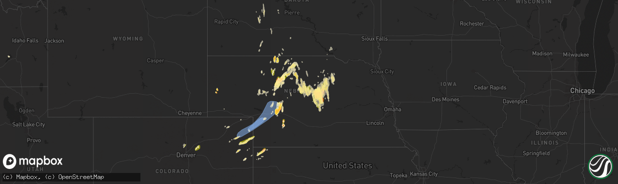
Hail
Wind
15,097
Estimated number of impacted properties by a 1.00" hail or larger7,356
Estimated number of impacted properties by a 1.75" hail or larger489
Estimated number of impacted properties by a 2.50" hail or largerStorm reports in Nebraska
Nebraska
| Date | Description |
|---|---|
| 05/14/20256:57 PM CDT | A local report indicates 1.75 inch wind near 2 NW Wellfleet |
| 05/14/20256:53 PM CDT | Upr site. |
| 05/14/20256:51 PM CDT | A local report indicates 62 MPH wind near Sidney |
| 05/14/20256:45 PM CDT | Had 2 rounds of 2 inch hail the first at 4:15 mt and 5:45 mt. |
| 05/14/20256:40 PM CDT | A local report indicates 1.75 inch wind near 7 NW Maywood |
| 05/14/20256:34 PM CDT | Bff raws site. |
| 05/14/20256:11 PM CDT | A local report indicates 1.25 inch wind near 5 N Scottsbluff |
| 05/14/20256:11 PM CDT | A local report indicates 1.75 inch wind near 1 N Scottsbluff |
| 05/14/20255:58 PM CDT | Report of an overturned semi on highway 83 mm 174. |
| 05/14/20255:55 PM CDT | A local report indicates 64 MPH wind near Kimball |
| 05/14/20255:33 PM CDT | A local report indicates 1.00 inch wind near 8 ENE Ansley |
| 05/14/20255:30 PM CDT | A local report indicates 1.00 inch wind near Mullen |
| 05/14/20255:06 PM CDT | A local report indicates 1.75 inch wind near 11 WSW Brownlee |
| 05/14/20253:32 PM CDT | A local report indicates 1.75 inch wind near Nenzel |
| 05/13/20259:55 PM CDT | At cambridge airport. Intense outflow from combo of synoptic front and convective outflow. |
| 05/13/20259:45 PM CDT | Intense outflow from combo of synoptic front and convective outflow. |
| 05/13/20259:31 PM CDT | Report of 68 mph gust from pws. |
| 05/13/20259:27 PM CDT | Asos station kmck mccook airport. Visibility down to 1/2 mile due to dust. |
| 05/13/20259:19 PM CDT | 3w 1n trenton... Ne - knetrent7. |
| 05/13/20259:12 PM CDT | Visibility reported of 100 yards with estimated wind gusts of 60 mph as wall of dust moves through. Time provided by spotter. |
| 05/13/20259:08 PM CDT | Report with photos. Time estimated from radar. |
| 05/13/20259:08 PM CDT | A local report indicates 71 MPH wind near 11 NE Dickens |
| 05/13/20259:05 PM CDT | 5 to 10 inch diameter tree branches down across town. |
| 05/13/20259:04 PM CDT | Wnw trenton. 3w 1n trenton... Ne - knetrent7 |
| 05/13/20259:01 PM CDT | A local report indicates 67 MPH wind near 1 NW Sutherland |
| 05/13/20259:00 PM CDT | Public report from a pws 3w 1 n of trenton. |
| 05/13/20258:50 PM CDT | Lorens farms... Ambient weather. |
| 05/13/20258:47 PM CDT | At least the third round of hail in 45 minutes. |
| 05/13/20258:39 PM CDT | Hail to around quarter size...second round of hail in last 11 minutes from a new core. |
| 05/13/20258:33 PM CDT | A local report indicates 73 MPH wind near 10 S Wallace |
| 05/13/20258:31 PM CDT | A local report indicates 71 MPH wind near 4 SE Ogallala |
| 05/13/20258:30 PM CDT | Multiple 4 inch limbs down from trees during thunderstorm. |
| 05/13/20258:28 PM CDT | Hail up to half dollar size...more flat than round. |
| 05/13/20258:23 PM CDT | A local report indicates 76 MPH wind near 4 N Wauneta |
| 05/13/20258:21 PM CDT | Hail up to ping pong ball size...most smaller. |
| 05/13/20258:18 PM CDT | A local report indicates 79 MPH wind near 1 NW Imperial |
| 05/13/20258:15 PM CDT | Building damage and power poles snapped in imperial. |
| 05/13/20258:15 PM CDT | A local report indicates 82 MPH wind near 2 NNW Grant |
| 05/13/20258:12 PM CDT | A local report indicates 59 MPH wind near 1 NNW Imperial |
| 05/13/20258:12 PM CDT | A local report indicates 1.75 inch wind near 4 NW North Platte |
| 05/13/20258:10 PM CDT | Hail up to half dollar size...most smaller. Report less than a mile south of garfield county line. |
| 05/13/20258:08 PM CDT | A local report indicates 72 MPH wind near 11 N Imperial |
| 05/13/20258:05 PM CDT | A local report indicates 1.00 inch wind near 3 NW Burwell |
| 05/13/20258:04 PM CDT | A local report indicates 1.75 inch wind near Burwell |
| 05/13/20258:03 PM CDT | A local report indicates 1.00 inch wind near 6 NE Taylor |
| 05/13/20258:01 PM CDT | A local report indicates 1.75 inch wind near 10 W North Platte |
| 05/13/20258:00 PM CDT | Hail up to quarter size...most smaller. |
| 05/13/20257:57 PM CDT | A local report indicates 1.25 inch wind near 2 W Burwell |
| 05/13/20257:52 PM CDT | A local report indicates 60 MPH wind near 3 SSW Big Springs |
| 05/13/20257:50 PM CDT | A local report indicates 2.50 inch wind near 13 NW North Platte |
| 05/13/20257:49 PM CDT | A local report indicates 65 MPH wind near 6 SSE Chappell |
| 05/13/20257:48 PM CDT | Weatherlink station. |
| 05/13/20257:46 PM CDT | A local report indicates 75 MPH wind near 3 W Lewellen |
| 05/13/20257:39 PM CDT | A local report indicates 58 MPH wind near 3 W Lewellen |
| 05/13/20257:35 PM CDT | A local report indicates 58 MPH wind near 5 WNW Chappell |
| 05/13/20257:35 PM CDT | A local report indicates 64 MPH wind near Sidney |
| 05/13/20257:35 PM CDT | A local report indicates 1.75 inch wind near 2 S Hershey |
| 05/13/20257:35 PM CDT | Relayed report... Time estimated. |
| 05/13/20257:34 PM CDT | [landspout] estimated location of the landspout. |
| 05/13/20257:34 PM CDT | A local report indicates 59 MPH wind near 7 SSW Oshkosh |
| 05/13/20257:33 PM CDT | A local report indicates 63 MPH wind near 10 N Chappell |
| 05/13/20257:30 PM CDT | A local report indicates 59 MPH wind near 1 W Oshkosh |
| 05/13/20257:27 PM CDT | A local report indicates 1.75 inch wind near 8 W Burwell |
| 05/13/20257:23 PM CDT | [landspout] off duty nws employee reported an ongoing landspout 5 miles west of town. |
| 05/13/20257:18 PM CDT | [landspout] estimated location of 1 mile south of sutherland power plant. |
| 05/13/20257:15 PM CDT | Damage to roof on a metal structure - garage like structure... Estimated time. |
| 05/13/20257:11 PM CDT | [landspout] estimated location of 14 miles sw of hershy... Landspout continues on the ground. |
| 05/13/20257:08 PM CDT | [landspout] multiple reports and photos of landspout tornadoes. |
| 05/13/20257:04 PM CDT | Sunol upr site. |
All States Impacted by Hail Map on May 14, 2025
Cities Impacted by Hail Map on May 14, 2025
- Dunseith, ND
- Muenster, TX
- Saint Jo, TX
- Currie, NC
- Warfield, VA
- McKenney, VA
- Roxboro, NC
- Midland, SD
- Dinwiddie, VA
- Blackstone, VA
- Wilsons, VA
- Dewitt, VA
- Virgilina, VA
- Philip, SD
- Milesville, SD
- Stony Creek, VA
- Kittrell, NC
- Franklinton, NC
- Louisburg, NC
- Newton Grove, NC
- Clinton, NC
- Angier, NC
- Lillington, NC
- Washington, NC
- Florence, SC
- Coats, NC
- Willow Spring, NC
- Morganton, NC
- Valdese, NC
- Nebo, NC
- Union Mills, NC
- Bostic, NC
- Marion, SC
- Linden, NC
- Erwin, NC
- Dunn, NC
- Saint Pauls, NC
- Lumberton, NC
- Mcgregor, MN
- Powhatan, VA
- Benson, NC
- Spring Grove, VA
- Littleton, NC
- Enfield, NC
- Cumberland, VA
- Roseboro, NC
- Disputanta, VA
- Waverly, VA
- Marston, NC
- Wagram, NC
- Kilgore, NE
- Nenzel, NE
- Windsor, NC
- Colerain, NC
- Elizabethtown, NC
- Garland, NC
- Fayetteville, NC
- Loris, SC
- Sims, NC
- Salemburg, NC
- Bailey, NC
- Wilson, NC
- Ahoskie, NC
- Conway, SC
- Garysburg, NC
- Pleasant Hill, NC
- Halifax, NC
- Roanoke Rapids, NC
- Murfreesboro, NC
- Charles City, VA
- Valentine, NE
- Pendleton, NC
- Gaston, NC
- Cody, NE
- Williamsburg, VA
- Sumter, SC
- Mullen, NE
- Clarkton, NC
- Manning, SC
- Tar Heel, NC
- Scotland Neck, NC
- Hope Mills, NC
- White Oak, NC
- Oak City, NC
- Goldsboro, NC
- La Grange, NC
- Harrells, NC
- Zebulon, NC
- Godwin, NC
- Laurinburg, NC
- Oxford, NC
- Wakefield, VA
- Rose Hill, NC
- Wallace, NC
- Trego, WI
- Dendron, VA
- Elberon, VA
- Erie, CO
- Lafayette, CO
- North Platte, NE
- Grantsburg, WI
- Faison, NC
- Hudson, CO
- Magnolia, NC
- Teachey, NC
- Longmont, CO
- Keenesburg, CO
- Bennett, CO
- Alcolu, SC
- Roggen, CO
- Campobello, SC
- Chesnee, SC
- Hobgood, NC
- Willard, NC
- Aberdeen, ID
- Broadway, NC
- Fuquay Varina, NC
- Longs, SC
- Kinston, NC
- Inman, SC
- Comstock, NE
- Arcadia, NE
- Ansley, NE
- Thedford, NE
- Saint Francis, SD
- Crookston, NE
- Belvidere, SD
- Long Valley, SD
- White River, SD
- Tryon, NE
- Broken Bow, NE
- Sargent, NE
- Mission, SD
- Westerville, NE
- Burwell, NE
- Taylor, NE
- Gering, NE
- Scottsbluff, NE
- Wood, SD
- Maywood, NE
- Sterling, CO
- Hershey, NE
- Martin, SD
- Wellfleet, NE
- Otis, CO
- Akron, CO
- Potter, NE
- Yuma, CO
- Stratton, CO
- Seneca, NE
- Brewster, NE
- Wanblee, SD
- Wood Lake, NE
- Eckley, CO
- Kirk, CO
- Allen, SD
- Johnstown, NE
- Dunning, NE
- Purdum, NE
- Wray, CO
- Ainsworth, NE
- Idalia, CO
- Vernon, CO
- Long Pine, NE
- Sutherland, NE
- Hayes, SD
- Anselmo, NE
- Sedgwick, CO
- Stapleton, NE
- Elsmere, NE
- Parkton, NC
- Fort Pierre, SD
- Saint Francis, KS
- Haigler, NE
- Holyoke, CO
- Ord, NE
- Halsey, NE
- Elyria, NE
- Champion, NE
- Bird City, KS
- Whitman, NE
- Springview, NE
- Amherst, CO
- Haxtun, CO
- Paoli, CO
- Madrid, NE
- Julesburg, CO
- Venango, NE
- Imperial, NE
- Grant, NE
- Elsie, NE
- Ogallala, NE
- Merriman, NE
- Paxton, NE
- Arthur, NE
- Keystone, NE
- Bishop, TX
- Roma, TX
- Scotia, NE
- North Loup, NE
- Zapata, TX
- Litchfield, NE
- Hyannis, NE
- Bassett, NE
- Loup City, NE
- Amelia, NE
- Stuart, NE
- Atkinson, NE
- Ericson, NE
- Chambers, NE
- Butte, NE
- Fairfax, SD
- Ewing, NE
- Lake Andes, SD
- Geddes, SD
- Kingsville, TX
- Inman, NE
- Emmet, NE
- Oneill, NE
- Page, NE
- Farwell, NE
- Rio Grande City, TX
- Elba, NE
- Niobrara, NE
- Greeley, NE
- Orchard, NE
- Springfield, SD
- Tabor, SD
- Avon, SD
- Bartlett, NE
- Tyndall, SD
- Lesterville, SD
- Scotland, SD
- Utica, SD
- Royal, NE
- Wolbach, NE
- Spalding, NE
- Winnetoon, NE
- Creighton, NE
- Viborg, SD
- Clearwater, NE
- Primrose, NE
- Elgin, NE
- Bloomfield, NE
- Neligh, NE
- Woodsboro, TX
- Brunswick, NE
- Plainview, NE
- Mathis, TX
- Odem, TX
- Taft, TX
- Tomball, TX
- Hockley, TX
- Cypress, TX
- Dilley, TX
- Burbank, OK
- Four Oaks, NC
- Rutland, SD
- Colman, SD
- Flandreau, SD
- Egan, SD
- Ruthton, MN
- Elkton, SD
- Edgerton, MN
- Trent, SD
- Jasper, MN
- Pipestone, MN
- Garretson, SD
- Holland, MN
- Woodstock, MN
- Lake Benton, MN
- Balaton, MN
- Hendricks, MN
- Ivanhoe, MN
- Tyler, MN
- Arco, MN
- Russell, MN
- Lynd, MN
- Mount Olive, NC
- Tracy, MN
- Garvin, MN
- Gary, SD
- Clear Lake, SD
- Strandburg, SD
- Goodwin, SD
- Watertown, SD
- South Shore, SD
- Twin Brooks, SD
- Marietta, MN
- Odessa, MN
- Revillo, SD
- Labolt, SD
- Stockholm, SD
- Big Stone City, SD
- Bellingham, MN
- Milbank, SD
- Corona, SD
- Marvin, SD
- Ortonville, MN
- Summit, SD
- Wilmot, SD
- Peever, SD
- Graceville, MN
- Dumont, MN
- Beardsley, MN
- Barry, MN
- Clinton, MN
- Correll, MN
- Renville, MN
- Wabasso, MN
- Iron Belt, WI
- Sacred Heart, MN
- Redwood Falls, MN
- Clements, MN
- Morgan, MN
- Morton, MN
- Franklin, MN
- Hugo, OK
- Sawyer, OK
- Gibbon, MN
- Hector, MN
- Fort Towson, OK
- Buffalo Lake, MN
- Valliant, OK
- Rufe, OK
- Wright City, OK
- Broken Bow, OK
- Stewart, MN
- Hutchinson, MN
- Ringold, OK
- Brush, CO
- Wiggins, CO
- Fort Lupton, CO
- Snyder, CO
- Hillrose, CO
- Log Lane Village, CO
- Fort Morgan, CO
- Fleming, CO
- Strasburg, CO
- Commerce City, CO
- Brighton, CO
- Denver, CO
- Woodrow, CO
- Watkins, CO
- Byers, CO
- Lindon, CO
- Orchard, CO
- Weldona, CO
- Merino, CO
- Harrisburg, NE
- Galeton, CO
- Kersey, CO
- New Raymer, CO
- Stoneham, CO
- Lodgepole, NE
- Padroni, CO
- Atwood, CO
- Carpenter, WY
- Bushnell, NE
- Gill, CO
- Ovid, CO
- La Salle, CO
- Dix, NE
- Iliff, CO
- Peetz, CO
- Grover, CO
- Briggsdale, CO
- Pine Bluffs, WY
- Kimball, NE
- Sidney, NE
- Greeley, CO
- Crook, CO
- Burns, WY
- Ault, CO
- Eaton, CO
- Hereford, CO
- Cheyenne, WY
- Nunn, CO
- Lucerne, CO
- Platteville, CO
- Evans, CO
- Pierce, CO
- Windsor, CO
- Milliken, CO
- Henderson, CO
- Thornton, CO
- Louisville, CO
- Boulder, CO
- Broomfield, CO
- Westminster, CO
- Dupont, CO
- Aurora, CO
- Dacono, CO
- Johnstown, CO
- Gilcrest, CO
- Firestone, CO
- Frederick, CO
- Carr, CO
- Anton, CO
- Joes, CO
- Cope, CO
- Vona, CO
- Seibert, CO
- Flagler, CO
- Kanorado, KS
- Burlington, CO
- Bethune, CO
- Benkelman, NE
- Parks, NE
- Dalton, NE
- Bridgeport, NE
- Gurley, NE
- Bayard, NE
- Chappell, NE
- McDonald, KS
- Edson, KS
- Enders, NE
- Max, NE
- Wauneta, NE
- Goodland, KS
- Hayes Center, NE
- Atwood, KS
- Palisade, NE
- Stratton, NE
- Wallace, NE
- Ludell, KS
- Trenton, NE
- Herndon, KS
- Culbertson, NE
- Dickens, NE
- McCook, NE
- Brule, NE
- Lewellen, NE
- Big Springs, NE
- Lemoyne, NE
- Oshkosh, NE
- Broadwater, NE
- Lisco, NE
- Hillsdale, WY
- Arriba, CO
- Kit Carson, CO
- Hugo, CO
- Levant, KS
- Cheyenne Wells, CO
- Wallace, KS
- Sharon Springs, KS
- Winona, KS
- Weskan, KS
- Colby, KS
- Brewster, KS
- Arapahoe, CO
- Monument, KS


